
DOUBLE HUMP DOME
BESIDE HUGE CRATER
Report # 013
January 27, 2001

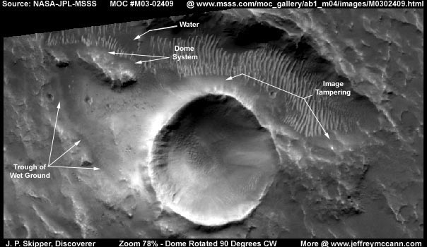
This evidence is extracted from NASA/JPL/MSSS's original MOC M03-02409 image strip. My images here are rotated 90 degrees clock wise to provide a more comfortable view and to fit my horizontally wide style of imaging. This represents no viewable distortion.
The huge crater is very dramatic and dominates this scene but the real anomaly here is the elongated double hump dome system pointed out with my arrows above. As you can see, the main dome area appears to be a single dome system constructed by joining two upper dome arched surfaces together. The two "humps" of the two dome top surfaces can be clearly seen. There is also a 90 degree turn in the dome system projecting to the left in the rear that can not be seen as well as the main area. As you can also see here, the main dome area appears to be lit from within.
Note the general terrain here and the big pointed end elliptical trough or depression in the ground above and either side of the crater with the field of ridge forms in it. When these ridge forms are real and not image tampering, in my experience with Mars images, they mean water and there is water present here in this depression. Now note the ravine system on the left side of the crater extending downward literally from under the dome system. These terrain features are going to be important to the understanding of what is going on here with this dome system and what it is designed to do for its occupants.

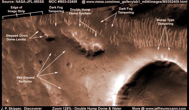
Above is a closer now colorized view. The double hump main area of the dome system can be seen to be lighted from within but where that light source originates from is not obvious at all. Note that it is obviously not visible in the upper or mid levels within the dome. Rather, it appears to be coming from some lower ground level source at the base of the buildings seen inside the dome. Most of the lightest areas inside the dome that we can see are actually a ground level light source reflecting up and off the side of lighter colored buildings. For us here on Earth, this is a strange unfamiliar concept since our experience is with overhead street lights and other upper level light sources providing general lighting.
Note that the clear humped dome material is sitting on a base that appears to be what looks like some dark irregular rock material. I have seen this kind of base material in other domes and circular areas on Mars in the midst of other more easily interpretable anomalies. Some have domes on them but others didn't seem to have any domes that I could see and yet there seemed to be a diffuse light coming from the interior ground level. In the beginning, I assumed they were craters (my own conditioning) but didn't really look just like impact craters. They looked more like low walled natural appearing enclosure constructs with the walls being made of some dark irregular rocky material. But, I didn't understand what was going on with that and therefore didn't report on it. Now I think that I have more experience and a viable "theory" as to what is going on with this and the key, as it has always been with anything having to do with intelligent life on Mars, is WATER.
My steadily increasing experience with these Mars images now tells me that the ridge forms immediately up against the rear of the dome represent a spillway from a slightly higher level of ground that contains pooled water to the dome on a slightly lower level. The water comes down this spillway in a thin layer via a probably intentionally controlled flow. The water born colony organism that I have mentioned elsewhere in other reports flourishes in this shallow thin layer of flowing water. I suspect that what ever it digests in the water produces deposits of solid minerals which are pushed away out to the side.
As any two patches of this micro organism push this waste product to the side out of its way and out of the way of the water flow, it bunches up higher and higher forming solidified rock ridges between them that you seen here and which I call ridge forms. The higher this ridge of waste material sticks out of the water and dries out, the harder and lighter color it takes on. The ridges further serve to channel water flow over each now separated colony patch of organisms down the spillway. The process has a few similarities to the coral colony organisms here on Earth that leave behind hard coral rock reefs long after the colony itself has died out.
The remains of old ancient spillways or very shallow but persistent water pool sites are seen over and over again in the Mars topography land record because these mineral rock ridges are very hard and resistant to time's wear and deterioration. Some of these, in their most healthy younger states of development, have originally been mistaken for "Tubes" because of their long length, even uniformity, and wider interspaces between the ridges. I made that very mistake myself early on in examining these images with my report on "The Real Smoking Gun as to Life on Mars" found HERE when I first reported at "Sightings" Richard Hoagland's discovery of one of these in the M04-00291 image strip but got the reasoning wrong. They are not a giant single tube like life form but a colony micro organism life forms. The spillway slope itself may occur naturally in the terrain but is also often a product of artificial construct by some of the intelligent life forms on Mars that desire this water arrangement and/or benefit from it.
In any case, the water comes down the gentle spillway slope to the far side of the double hump dome's rocky base and penetrates it in some way. Water may be retained in the interior of the dome where the base of buildings sit in it. The lighting in this dome's interior may well be a similar powerful light source that I have now seen now a number of times associated with water and the possible processing of same on Mars and which I have previously reported on. If you can accept these concepts, then it is natural for Earth humans to assume that this light may serve to disinfect the water of the organism rendering it clean enough to be acceptable for the dome folks use around the base of their buildings in this dome. But, it might also work in reverse. The organism requires shallow water either standing or flowing and that probably means that light and elements in the air (oxygen?) may be needed for life processes along with the shallow water. If so, it may be that the light source is used to accelerate the organism's growth and the organism rich water may be used as a nourishment source for the occupants of the dome. In other words, despite being inside a dome with elevated buildings inside, this may still partially be a aquatic environment here.
The water is not held permanently in the dark rocky base of the dome system but seeps through it and the water loss then goes down the ravine slope keeping it damp as seen in these images but not enough to pool the water at the ravine bottom. The ravine itself may be created by a periodic or occasional strong flow of water released through the dome base to flush things out.

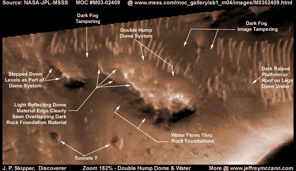
In the above even closer view, the dome and its irregular dark rocky base can be seen better even though we are now beginning to push the limit of this image strip's resolution on objects of this size. Think for yourself and don't leave it to others to convince you that this is just ice or some bright reflective land form. The dome's main area resin material can clearly be seen overlapping a top surface section of the dark rocky base as pointed out with arrows above. The inner edge of that dark rocky base can be clearly seen well inside the dome interior in the overlap area and being highlighted by background low level lighting. This demonstrates that this is clear dome material over the dark rocky base. The dark rocky base and the clear dome material together constitute the full dome system here.
Note the two tunnels constructed one on each slope of the ravine directly opposite each other pointed out with arrows. These are clearly horizontal tunnels demonstrated by the fact that the front bottom lip of the tunnel opening sticks out further than the top edge of the opening forming extended bottom ledge. Note that it does not appear that water flows out these two holes as the ground immediately below them shows no signs of water erosion. Note that there is no debris below these openings. Note that there are no roads or other signs of use around the tunnel openings. Now note the size of these two tunnel openings in relation to the size of the indistinct (insufficient resolution) buildings within the dome. As you can see, these tunnel openings are very large relative to the dome interior buildings.
Therefore, could this be a entrance/exit for aircraft? It is certainly big enough for that purpose. Alternatively they could be air exchange openings located in the ravine to take advantage of the moisture laden oxygen rich air as the dampness in the ground slopes evaporates its water. If one is an exhaust and the other is intake, the air pull across the ravine between them would maximize utilizing the moister air principle. If this is what these two tunnels are, then there may be as much or more facility below ground here as above under the dome. The only trouble with this vent concept is that the tunnels appear to be far too large to serve just this air exchange purpose alone. Possibly they serve both purposes, air traffic and moist oxygen rich air ventilation?
Another very curious feature of this overall dome system is the smaller left rear 90 degree left angled projection area. The light area to the left in this projection appears to be multiple levels stepped down the ravine slope. The step levels going down can be seen in the dark base material at the left edge. Unfortunately, this area of the whole larger dome system must have shown enough geometric shapes that it attracted the automated tampering software's attention. There is a light dribbling of dark fog treatment over the lighter shaded area and a heavy application right where the left angle projection joins the main humped dome area. This can be seen by blowing up the images more, lightening it more, and also inverting the image. Sorry but there just wasn't enough room here in this report to show you all this with more images.
The water pools just above the ridge forms that supplies the water to the dome area are there all right but hidden under more of this same dark fog image tampering. The tampering is probably there because there were geometric shaped buildings sitting in the pooled water at the top of this spillway. I make this speculation without actually being able to see it because my growing experience indicates to me that this is normal procedure for some of these folks on Mars. They build buildings in the open in the shallow standing water at the top as well as at the bottom of these spillways. If this is hard for you to consider objectively because it is so different from the way we do things here on Earth, remember that this is Mars and not Earth. At least a partial aquatic life style is very important to at least one culture on Mars and this anomaly site appears that it may be part of that culture.
Now please understand that I can not conclusively see the pooled water at the top area of the spillway because of the image tampering. Also because of the thickness of the older ridge forms being so close together. However, after discovering over 20+ standing liquid water discoveries so far on Mars (most not yet reported on), I have learned to recognize the appearance of general wet or very damp ground surface conditions. Based on that experience, my opinion is that the ground surface slopes of the ravine system that goes up to the dark rocky irregular base of the dome system is very damp or wet even though I see no pooled water in the bottom of the ravine. The water flow is not enough to make it down to the bottom before soaking into the ground. This and the interior dome lighting conditions tell me that this dome environment has a high probability of being currently operational although that is admittedly not conclusively certain.
DOCUMENTATION
http://www.msss.com/moc_gallery/ab1_m04/images/M0302409.html: The evidence here is taken from NASA/JPL/MSSS's original MOC M03-02409 image strip. I downloaded the 2nd listed best quality slower loading sinusoidal projection gif image and extracted my evidence from that. The anomaly is about 70% down the strip on the left and the giant crater insures that you can't miss it. For those interested in checking behind me in the original NASA image, be aware that the 1st listed medium quality faster loading image has the same orientation, it is a larger view image, and the dome can be seen just fine in it since you know what to look for and where. Just remember that the original has a vertical orientation and my images here have been rotated 90 degrees clock wise by me to provide a more comfortable view. WARNING! The 3rd listed slower loading not map-projected gif image has been flipped both vertically and horizontally by MSSS which does considerably distort anomaly objects. I have not accessed this image at PDS or USGS and so I can not comment on it there at those sites. Good luck.
, Discoverer
![]()