
DOME & NEARBY LIGHT
BEAM EXITING TUNNEL
Report #015
February 1, 2001

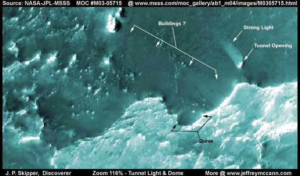
This anomaly evidence is extracted from NASA/JPL/MSSS's original MOC # M03-05715 image strip. Note that the above image represents the entire original image strip from one side to the other. There are two main anomalies here, a dome in the foreground just right of center and a huge tunnel emitting a very powerful beam of light in the background down in a hole area right of center.
This huge tunnel opening is given away and identified by this very strong light beam emanating from within it. While the tunnel is located in medium shadow down in this low ground area, other higher elevation terrain around it is in strong sunlight. So, the light source inside this tunnel that shines so visibly for us to see must be extremely powerful. As some of you who have read my previous reports know, I am often finding very strong artificial lights in some of these Mars images. Usually the actual light sources are hidden from view but there is one exception in my report titled "The Real Smoking Gun as to Life on Mars" found HERE where there is a super bright glowing orb suspended inside a cylinder out in the open in broad daylight. The point being that there is a high technology on Mars that uses light not only to illuminate but as a tool of power.
The dome you see here is round shaped as we Earth humans might expect a dome to look and we can see a spot of light reflection off of the dome's clear glassy outer surface. Our view of its exterior is fairly good, but our view within the interior appears to be blocked by what may be another inner dome shaped darker surface. Note that this dome is located in some very light colored highly reflective terrain that looks like it may be ice. If it is ice, it may be that this is a dual dome providing trapped air space insulation between the outer and inner dome surfaces inhibiting cold penetration and the inner dome's outer surface may be treated with or be covered by something dark that filters the extremely bright natural light in evidence here.

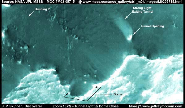
The above image just provides a closer view of these anomalies better demonstrating what I have discussed above. The only new thing this brings out is the swath of some semitransparent looking haze that starts from the area between the dome and tunnel and extends up into the upper left corner of the image. This appears to be image tampering to me probably obscuring buildings and other geometric structures under its path. The tunnel light would not have been recognized by the automated tampering software because of its transparency explaining why it escaped covering treatment. The dome would not be recognized either because it is round, clear, and partially transparent. I have discussed the nature and flaws of this automated tampering software in other reports and will not repeat them here.
DO FLIPPED IMAGES HAVE ANY IMPACT ON THIS DISCOVERY?
Detractors may claim that I flipped the original image both vertically and horizontally before taking my data from it which would have introduced considerable distortion in these images. If my images above were sourced from material flipped vertically and horizontally, the impact would be that the dome would be obliterated and the light beam, instead of shining up from a tunnel down in the ground as appears here, would appear to be natural sun light shining from above and down on the back of the cliff and through a hole in the opposite overhanging cliff face at a downward angle. Their point would be that I intentionally flipped my images or I just got confused over flipped images at MSSS's site and therefore there is a perfectly natural explanation for this intense light beam.
Now, of the three view choices of this particular image that are available at Malin's web site, the 1st listed faster loading medium quality sinusoidal projection jpeg image works and provides the same orientation view you see here in this report. The 2nd listed slower loading best quality sinusoidal projection gif image does not work at all and has never worked over the last 5-6 months it has been since I originally made this discovery. The 3rd listed slower loading not map-projected image has been flipped at official level both vertically and horizontally and would have provided the view where it appears that strong sun light shines on the back of a cliff and down through a hole in the opposite cliff face bank. The light beam explained as sun light through this cliff face hole sounds logical and images from this view look good. Therefore, such a explanation might be believed by some who are not aware of the full facts.
However, this narrow-angle M03-05715 image has with it a wide angle M03-05716 context image with the outline of the narrow-angle M03-05715 image strip orientation clearly outlined within it as is consistent with many of the MSSS images. I have been very careful to confirm that the outline and the land patterns within that M03-05715 outline in the context image matches perfectly with the 1st listed jpeg image strip view orientation providing my image here. This conclusively demonstrates that the 1st listed jpeg view is the correct orientation as matches my images above and that the 3rd listed image is a incorrect orientation view that has been flipped vertically and horizontally at official levels which is often the case with these MSSS images. Also, any such assertion would have to ignore the fact that in this very same 3rd listed view, the back of that cliff the sun light is suppose to be shining on and through can be seen fully and there simply is no hole in evidence in the back of the cliff to be shining through. The tunnel is huge and any opening for something that large for that much sun light to shine through should be visible but is not because it isn't there.
I apologize for going through this boring technical discussion here but the difference between these two image strip views seemed a little too coincidental to me, particularly with the 2nd listed best quality link not working. So, I am just trying to deal with it up front just in case this situation between the two available views was by design.
DOCUMENTATION
http://www.msss.com/moc_gallery/ab1_m04/images/M0305715.html: The evidence here is taken from NASA/JPL/MSSS's original MOC M03-05715 image strip. I down loaded the 1st listed faster loading medium quality sinusoidal jpeg image strip and extracted my evidence here from that. Please note the discussion above for information as to the 2nd and 3rd listed image strips and the problems with them where the 2nd doesn't work at all and the 3rd has been flipped vertically and horizontally by MSSS. I have not accessed this image at PDS or USGS and so I can not comment on it there at those sites. Good Luck.
, Discoverer
![]()