

THE "TUBES"
NATURAL GEOLOGY OR LIFE?
Report #018
March 29, 2001
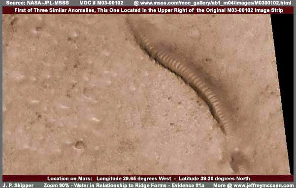
The most obvious anomaly in the above MOC M03-00102 image strip is one of the now famous "Tubes" first reported in the M04-00291 strip. Actually there are two other "Tubes" sites in this image strip but I'm going to use only variations of the above representative image for the purposes of most of this report since it contains a little of everything such as tubes, water, tampering, and even a bit of civilization evidence. Before getting to the core of my hypothesis on this subject matter, let's first get a perspective of what has gone before and how I fit into this for better understanding.
SOME BACKGROUND
First, Richard Hoagland at his web site HERE presented, as far as I know, the first anomaly image of the so called "Tubes" in MOC MO4-00291 and identified them as glass tubes or worms. Then I came along, accepted this description in basic, then took the initiative (since Hoagland appeared to doing little with it), and spread this discovery around the world in the media along with my own speculations that these objects appeared to be "Tubes" of some kind perhaps to secure and preserve water because that is what they looked like in the images provided by others at the time. You see, back then, I did not have the software to examine these anomaly objects in fine detail for myself. Later I secured that software and my eyes really began to open and see.
One of the first things that I discovered on reexamination of this M04-00291 anomaly scene was that image tampering, apparently at official level, had helped create the illusion that these objects had a "Tubes" or "Worm" appearance to them. The main illusion in M04-00291 was the terminating end of one tube seeming to ride up on top of and attach to another tube below it which gave the "Tubes" concept a big boost to the casual view. However, on detailed reexamination, what appeared to be terminating end turned out to actually be hard core civilization evidence as I've reported on HERE. I discovered that a layered form of diffuse image tampering making some passes round the civilization evidence and distorting it to hide it created this terminating end look. It might have been intentional but more than likely it was just a accidental result of automated tampering.
While I was reasonably convinced of the nature of the tampering, at that time I had not enough experience to be sticking my neck on it, especially after discovering that I had already been wrong about something. Further, if the ridge forms were not tubes, then what were they? This was much more difficult to answer and I wasn't prepared to tackle that back then either. However, after several months of examining many hundreds of images, I finally had enough experience to fully recognize and confirm this tampering in many of its different forms and make the call with surety as to it being tampering. Further, I believed then and now that I have discovered the nature of the ridge lines themselves. I then posted a revised investigative report HERE recanting part of my original speculation as to the "Tubes" concept, identifying and imaging the new dramatic civilization evidence I had discovered, and presenting briefly my discoveries on what the ridges actually are.
CURRENT CONTROVERSY
Now, recently, Arthur C. Clarke made some brief comments in a news conference about the probability of finding life on Mars with an indirect inference toward the "Tube" forms. This deservedly famous man and his opinions carry great weight with the public around the world and with the media. As Hoagland says, this caught the tightly controlled traditional media off guard as they did not expect him to break party ranks on them. Obviously, Sir Clarke smells a rat and has an clear eye fixed on how posterity will see his body of visionary work and doesn't want to get tripped up when Mars finally does fully reveal itself which is inevitable and he knows it.
This energized Hoagland and crew to promote his comments and the combination brought quick reaction from NASA/JPL's spin control machine. The damage control comments of two top level geologists Dr. Bernard Haisch, Director of California Institute for Physics & Astrophysics and Dr. David Pieri of JPL are, in my opinion, designed to deliver some truth while at the same time perpetuating a serious misconception at minimum as to what the ridge forms are.
Unfortunately, Richard Hoagland seems stuck on continuing to assert that the ridge form anomalies are giant glass tubes or tunnel systems or possibly even a giant life form (worm) of some kind. Of course this is very dramatic stuff that catches the imagination of many and NASA and company do not like it or its direction. So out came the fore mentioned Drs. Haisch and Pieri who identify these anomalies as natural land forms inside a valley system. Specifically the ridges themselves are asserted by both men to be transverse (lying across) dune trains on the valley floor.
MY TWO CENTS
As if have stated in my previous revised report found HERE that I posted months ago, these ridge forms are not giant tubes, tunnels, conduits, or worms. That puts me in unfortunate disagreement with Richard Hoagland which I suspect the NASA and JPL side will be glad to hear of. Further, I agree with the Drs. Haisch and Pieri that these anomalies are natural on Mars which may please the NASA side to some small extent. However, the ridge forms themselves are not dunes of any kind and I suspect these two top flight scientists and NASA/JPL well know this unless there are some serious competency issues there.
The key to understanding these ridge forms is to understand that they are always associated with WATER on Mars, whether the water is currently present or has been present in the locale in the past. I have thought for many months as to how best to present this concept with some decent clarity, yet without so many images that would require a book to include them all. The problem is that a full analysis of this subject matter would probably take 200-300 pages of dialogue and 20-30 images at minimum to properly present which isn't possible here in this Internet forum. Still, the recently reactivated controversy caused by Sir Clarke's comments in the media has motivated me to try with just a representative sample of images included here to convey the truth of this matter.
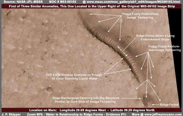
In the above image, we have the same "Tube" anomaly shown at the beginning of this report but now with my arrows and labeling which clearly demonstrates different details and concepts than that those supported by the opposing Hoagland and NASA camps. Now take a look at the same image below but now inverted with only the labeling otherwise changed.
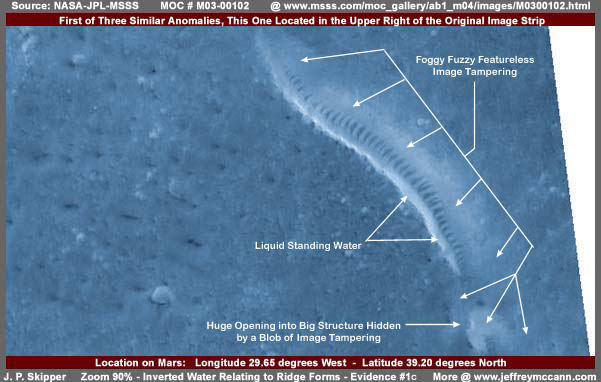
Now, between these two images, anyone should be able to see the carefully crafted color coordinated foggy, fuzzy, featureless, no detail, image tampering and how it differs so markedly with the surrounding natural terrain detail. Being able to recognize this image tampering is essential to understanding what is really going on with the "Tube" anomalies and everything else important on Mars. You scientist out there, if you are unable to identify this image tampering for what it is and/or acknowledge its existence, then I am genuinely sorry for you. You are missing one of the greatest discovery events of our time as to what is on Mars and are leaving it to amateurs to pick up the ball and move on with it. Is this what you really want and how you want to be remembered in posterity?
What we have here is, not exactly a valley but a water trough or trench system, probably artificially excavated in the earth but on the size dimensions of a long canyon. From the intentional design, there is probably a slight grade with higher ground to the right and lower ground to the left. Water flows over substrata under the ground surface level from right to left. The trough or canyon system cuts across this natural underground water flow and forms a catch system. The left side of the trough forms a sharp edged vertical cliff wall and a earth dam to the impede water flow helping the catch system to collect water. In the center left of the trough down it length ways is the water itself crossing from the left bank to the right bank up against the base of the ridge forms.
On the right bank of the trough is a ground slope. I have seen it over and over again in the MOC images, where shallow water flows down a slope, a organism in the water flourishes and populates the slope in the water. This organism's interaction with sunlight, air, water, and minerals in the water, produces a mineral byproduct (waste?) that is pushed to the side forming these mineralized creted ridges oriented in the direction of the water flow from the top to the bottom of the slope. The ridges serve to channel and concentrate the water flow. Both the shallow and flowing nature of the water are important to this organism, probably to maximize exchange with new constantly replenishing water resources (minerals?) and sunlight and air.
The younger the slope/water anomaly site is, the wider the interspace distance between each ridge form and the more narrow and sharper edged are each ridge's peak ridge lines. Note that this description more fits the anomalies in MO4-0291. The older the site and assuming shallow water has continued to flow fairly consistently, the broader and thicker across each ridge form becomes and the more narrow the interspace between any two or more ridge forms becomes which is more the case here in this M03-00102 anomaly site.
Note also in these images that each down the slope ridge thickens in the middle and tapers to form a more narrow profile at the bottom and top ends. The broader aspect in the middle may also mean that each ridge is slightly higher in the middle than at the ends. This would create a slight outward curvature to each ridge and, when they are lined up and seen more or less at angle broadside, the effect increases to create the illusion that the whole line is rounded which in turn creates the illusion of a tube effect. The eye concentrates on the ridge form tops and ignores the fact that the interspaces between the ridges remains flattened. Different views of the line and different lighting conditions would also accentuate this illusion.
A important factor to remember is that these ridges always appear on one side wall of the canyon, trough or valley system, not transversing across the bottom center of the system as might be more consistent with the "transverse dunes" concept. That is because the ridges are formed in relationship to shallow water flowing down at least one sloped side wall or bank of the canyon system. The only time the transverse dunes "look" may appear to be the case occurs when the remnants of the ridge form train is seen in a old long dead fossil archeology where wear by the elements has shifted the surrounding terrain appearance around over time resulting in a more centered look in a valley system or exposed ridge look with the hard and tough ridge forms anchoring the center and resisting wear.
Another important fact to remember is that You will usually always see that all of the individual ridges stop near the bottom in a level line. In a active live ecology, as here in these images, this is consistent with the ridges being immersed in a level water line even if the water is still and clear enough that it can not be seen very well, again as here in these images.
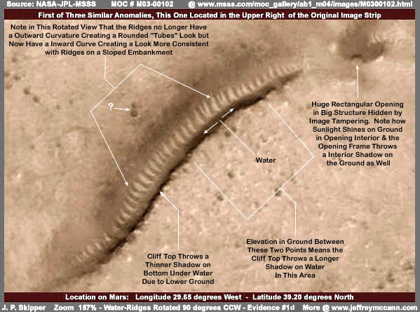
The above and below images of this same anomaly site have been rotated by me 90 degrees counter clockwise. In this rotated view, you can see that the appearance of the ridge forms shows a inverse curvature which now supports the look that these are all ridge forms down a slope and not the outer rounded form of a "Tube." This at the very minimum demonstrates how easy the rounded tubes or worm look can be misinterpreted. Now take a look at the same scene inverted as below.
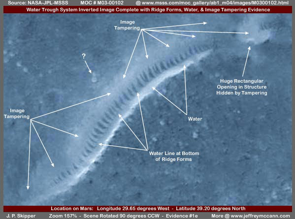
As in the first inverted view, the most telling evidence here in this inverted view for any objective viewer to see is the recognition of the foggy fuzzy featureless image tampering so thick on the upper and both ends portions at the ridge form line. It is more difficult to see in the original black and white image as well as the color images here but the inverted image demonstrates the difference between the true higher detail surrounding natural terrain and this artificial featureless tampering application up close to the ridge form line.
The broadness of each ridge form and the narrowness of the interspace between each one and the one next to it tells me that this water based organism has been doing its thing here at this locale for a long time. These ridge forms are thick and therefore somewhat old. From this point of view, we are looking at a old and stable living ecological system in the environment here.
My original title promoting the first M04-00291 "Tubes" discovery as "The Real Smoking Gun as to Life on Mars" is still valid. It's just that, instead of these ridge forms representing some giant tube or life form, the real truth is that a lot of small organisms in the water are building these raised mineralized ridge forms where shallow flowing water is present. The point is that it is still life and it is on Mars. Further, from the countless ridge form lines that I have seen in these MOC images scattered all over Mars including in dry locales where water is no longer present, this dry area fossil record demonstrates that this is an old life form apparently native to Mars. The survival of these ancient ridge forms in the fossil record demonstrates just how hard and tough they really are to stand up to the elements and time.
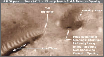
However, such natural native Mars life forms are not the only forms of life on Mars. In the above closer view of one end of the water trough system, a group of tiny tall buildings can just be seen at the edge of resolution which gives you an idea of the size scale here. More telling is a huge rectangular opening in a big structure that has been covered and hidden by a blob of dark image tampering. But, note how the sunlight shines on the ground INSIDE the opening and note how the top doorway overhead casts a rectangular shadow inside the opening on the ground as well. Obviously, this type of evidence clearly implies civilization and intelligent life. I suspect we are looking at a large industrial facility hidden from our view by this tampering which is sitting right on and/or in this water trough system making use of same.
The area immediately in front of the huge opening has received a lot of carefully color coordinated foggy/fuzzy image tampering which also crosses the trough system creating the illusion that the trough system ends at this point. But, if you will look closely just over the upper right edge of the dark image tampering on the large structure, you can see two ridge forms that the tampering missed. These ridge forms can be seen much better in the second image here in this report. This tiny bit of missed ridge form evidence demonstrates the true nature of this foggy, fuzzy, featureless tampering application and how it creates visual illusions that are not real but designed not only to hide objects but to distort and alter perception. Very subtle, very good, and very effective.
THE REAL DEAL WITH THE RIDGE FORMS
Hoagland and company assert that what I call a ridge form line is a integral tube of some sort or a giant life form. I take no pleasure in having to disagree with them on this. The top caliber NASA and JPL associated geologists assert that the ridge form lines are natural transverse dunes crossing a natural valley floor. I take no pleasure in having to disagree with this hypothesis as well. However, no matter how fantastic it sounds, at least Hoagland's assertions fit the visuals better if you don't examine the evidence too closely. But, these top flight geologist's assertion of "transverse dunes" across a valley floor doesn't even remotely resemble the visuals and are just as far off of the mark.
As it always is on Mars, the key to what is going on with these ridge forms is WATER. You scientist out there have got to get past the belief that standing LIQUID water on Mars just can't be. Frankly, you have been fed a line of bull in your Mars data for all these years at least since the Viking probes. How do I know? Because I have images demonstrating the image tampering dating back into the Viking images. You are living in denial on this subject and you've got to get passed this! Instead of denying that this is possible, you've got to start thinking about why it is possible. I have found many standing liquid water sites on Mars and can tell you that water is scarce but it is plentiful enough to support thriving extensive civilized Mars populations. This is the reality and we've all got to deal with this.
What the NASA associated geologists might identify as a "valley" system as presented here in this report is actually a intentionally excavated canyon designed to retain water as a huge trough system. One side presents a slope down which shallow water flows from a underground uphill gradual grade. Not evident here because it is hidden by the tampering is a long shallow water pooling catch/retention system at the TOP of this slope. Those who occupy this site prefer to locate their buildings not only at the edge of this long pool system but actually in it as well. This population prefers intimate very close contact with water. The foggy fuzzy featureless image tampering evidence is a mostly successful attempt to hide the building civilization evidence all along in and beside this pool system.
The water then overflows from this top shallow water pooling system down the slope to the canyon floor and the excess water pools there in deeper proportions serving as a reservoir. The ridges are formed on the slope by a colony organism that flourishes in shallow preferably flowing water interacting with the water, the nutrient resources coming down the slope with new water, the air, and the sunlight. I suspect that the organism excretes minerals which are intentionally deposited or pushed to the side out of the center of the water flow. Some what similar to coral here on Earth, these deposits crete together forming the individual hard raised ridges which are oriented in the water flow to present as narrow a non-impediment to the flow as possible. That means the each ridge is oriented in the same direction as the water flow down the slope. If the water flow remains relatively stable over time, then the organism flourishes over the same length of time and the ridges gradually get thicker and thicker and the water flow interspaces between them get more and more narrow as is the case here in my M03-00102 images.
The organism appears not to flourish as well in deeper still water. Note how each ridge form here in these images stops at their bottom at the same uniform level. This demonstrates their relationship with the water level present here in this trough system even though it cannot be well seen. At this particular locale, the opposite side of this trough system forms a high bluff or cliff wall. I suspect that the excavated material from this trough system is spread out over the nearby terrain.
At other locales on Mars, I have seen this intentional design take the form of a triple terrace system. In those cases, water pools at the top of the top slope and buildings mostly hidden by tampering occupy this level. The overflow from that top pool level then goes down the first slope complete with ridge forms and then pools at a lower second level where you again have buildings, again mostly hidden by image tampering. The overflow from this second pool level goes down a second slope complete with ridge forms to pool at a final third level. When the bottom third level is reasonably shallow with a river or billabong type drain off system, then there are buildings at this third level as well, again mostly hidden by image tampering. When viewed from a distance, the net effect is to see what appears to be two long "Tubes" paralleling each other in what appears to be a river system.
THE BIGGER PICTURE
There are two other such water trough sites in this same image strip and each forms a community civilization and population wise. However, the image tampering is heavier on them obscuring too much on both sides of the ridge form line and therefore the water, so I didn't use them here. This is often the case in these images.
But that is not all of the evidence available by any stretch. Now take a look at the wide-angle context image for the M03-00102 strip as appears below. This is the wide-angle context M03-00103 image that the narrow-angle M03-00102 evidence here was taken from. You can clearly see the outline of the M03-00102 strip thoughtfully provided by MSSS as reference and I have identified the three ridge form anomaly sites within it. The first one of the three is the one that I have used in this report.
However, the reason that I have included this image in this report is to demonstrate that there are in all probability a great many of these water trough sites scattered all over this broad region. My arrows only point out a few. Note that a great many are much larger and longer than the single site sample I've used here in this report. If we assume that most or all are similar to the one here in this report as to intelligent life usage, then you can see the large extent of potential civilization evidence in this one Mars image alone.
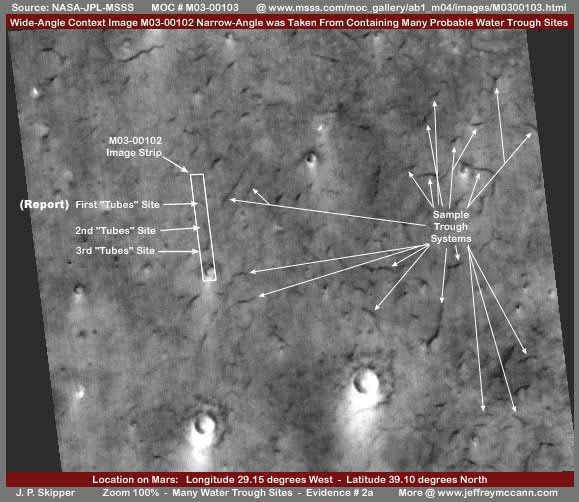
As my associate Jeffrey McCann said when he discovered this image (I had discovered it earlier) in his own research, there may be many hundreds if not thousands of these sites over the even wider area beyond the confines of this image. If each trough site is populated as the one I've used here appears to be based on the extent of image tampering around and on it, well you get the picture. We are talking about a huge population.
Also, note that each of these sites shows evidence of a hump in the ground on the side nearest us casting a shadow. This tends to favor my speculation that these are intentionally excavated trough systems where the excavated material is deposited to the side and spread out in and over the natural landscape elevating the ground in this area at some time in the distant past.
THE IMAGE TAMPERING TRIES TO AVOID HIDING WATER
Why did the image tampering not cover the ridge forms? Because the ridge forms always mean water either past or present and the secrecy types have made a special effort to preserve the water evidence for discovery where possible. Sometimes the civilization evidence that needs to be hidden is so thick that little view can be saved of the water for discovery. In other words, they want it to be found but evidently prefer that such discoveries work themselves out in the public first rather than NASA suddenly stick them in our face. Why? Because the acceptance of standing liquid water on Mars in reasonable plenty leads naturally and immediately to reactivating the issue of the question of life on Mars. Reasonable liquid water plenty conditions equates directly to the probability of life.
Once scientists are able to cross that concept barrier and begin to accept the water evidence, scientific closer and closer scrutiny of the water evidence to make sure of it is eventually going to uncover both the image tampering and the civilization evidence under it in bits and pieces (just as I am already doing) because where ever there is water on Mars, there is almost always civilization evidence. The tampering technology is superior as evidenced by how well the scientific community has been fooled by it. But, there is just too much civilization evidence to get it all and that is where I have been coming into the picture picking up the best missed bits and pieces.
WHY ALL THE SECRECY?
In my opinion, the secrecy types prefer that this be a gradually evolving awareness process and not a sudden one with us. Why? Because they have analysis of human behavior dating back half a century or more indicating that too much of this knowledge could destabilize the population and run the risk of eventually plunging us all into chaos. Think that argument is just too weak today? Well think again! For every one of us out there who are willing to review and consider the material I am presenting here, there are thousands who want no part of it because of its implications. I have seen this fear reaction over and over again to my work. Believe me, a willingness in the bulk of the population to believe in a ABSTRACT concept that there is life out there in the universe and that we are not alone does not equate to dealing with the sudden full reality implications of what Mars and its populations means to us and our past and our future.
There are a number of quite alien cultures on Mars but I can tell you that there is also a likely human or humanoid culture on Mars with a technology superior to ours and is has been superior to our current technology for a long time. It is logical to assume that such a culture would be able to make short easy work of a trip from Mars to Earth and has had that capability for a very long time. Think about the implications of that for awhile and see where it leads you and your belief systems. Now consider that not everyone on this planet is fortunate enough to be sucking on the horn of plenty like we spoiled Americans in the USA are and yet there are plenty here who would have trouble with the full implications numbering in the millions. In fact, there are billions of people around this planet who would seriously resist making a big sudden jump into a advanced age and leaving the familiar behind.
Yet, the march into the future is relentless and unavoidable and it is quite impossible to continue to successfully keep the secrets as to what is on Mars or for the population to remain in ignorance and denial indefinitely. Visionaries with tools of the electronic age are seeing to that. So the idea is to now dole out bits and pieces of information leading to a better understanding of what is on Mars. The public is expected to resist but gradually at its own pace digest and come to accept the reality in a way that provides for a soft landing rather than a hard destructive one as we turn the corner and enter into a advanced new age.
A CRUDE EXAMPLE OF "TUBES" IMAGE TAMPERING
I've included the below image here as an educational sample of both pure hiding image tampering and artful illusion creation image tampering relating to the "Tubes." What looks sort of like jets of vapor coming up from all along the "tube" top full length you see here is simply what I call sweep type tampering designed merely to hide what is behind it. This type of hiding tampering is mostly found on the sides and bases of bluffs and mesas seen at a distance on Mars as well as in large craters. In these applications, it blends in better but, here in this application, it is really too obvious. I find it incredible that Mars scientists do not question such obvious tampering and could think such a obvious artificial application could be natural.
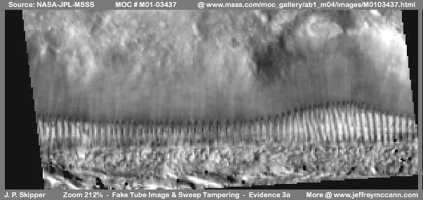
What is less obvious is this crude fake tube look. The first probably automated applied sweep tampering apparently left too sharp a dividing line between the bottom of the sweep tampering and the top of the ridges line as well as covering up the center area of the ridges line where geometric shapes were probably present. They came back and added tiny mismatched ridge edges by hand all along the top line as well as too sharply defined and darkened too thin vertical ridges in the center area of the line. All in all a relatively poor matching job and that is why I am including it here because I thought some of you might be able to see and properly identify this business since it is so crude. It appears that those doing the tampering thought so to, so they also tampered heavily with the resolution of this image which is why everything is out of focus. Like I say, all in all, a botched job.
MORE YET TO COME
The ridge forms small organism life form adaptation to shallow flowing water down a slope that I have identified on Mars are not the only small organism life form adaptation I have identified. In fact, my earliest identification of a similar life form on Mars actually dates back much further than the ridge form adaptation, right back to the beginning of my Mars journey in July, 2000. Now that I am focussed on reporting this type of organism discovery evidence on Mars, I'll try to get a report up on this separately soon, so keep a watch for it.
DOCUMENTATION
http://www.msss.com/moc_gallery/ab1_m04/images/M0300102.html: Most of my data comes from NASA/JPL/MSSS's M03-00102 and M03-00103 strips. I took my M03-00102 images from the second listed slower loading best quality sinusoidal projection gif strip. However, the first listed faster loading medium quality sinusoidal projection jpeg strip is just as good and has the same proper orientation. Warning! The third listed not map-projected gif strip has been flipped both vertically and horizontally at official level which seriously distorts anomaly images. Suggest you don't use that one. As for the M03-00103 wide-angle strip and the one image of the entire strip I presented here, all three listed MSSS views have the same proper orientation and all work. I took my image from the second listed best quality gif strip.
http://www.msss.com/moc_gallery/ab1_m04/images/M0103437.html: The image of "Tubes" tampering comes from the M01-03437 image strip here. I took my image from the second listed best quality sinusoidal projection gif image strip. The first listed medium quality jpeg strip works and has the correct orientation. However, the third listed not map-projected gif strip has been flipped vertically and horizontally at official level which will seriously distort anomaly objects. Suggest you do not use this one. I have not accessed this data at any other location such as PDS or USGS and can not comment on it there. Good Luck.
, Discoverer
![]()