
THE WELL OF ILLUSION
Report #034
March 11, 2002
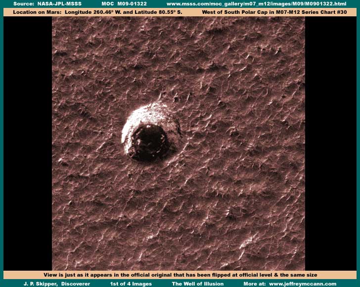
This is one of my water discoveries in the South Polar Region I've been saving for awhile. The above is the original view just as it has been officially presented. The effective image is smaller than I normally present because this is what you see in the official strips at 100% view from one side to the other. When I first saw this, I thought I had another water in a crater find just as was intended by the architects of this image. However, closer examination reveals that this is no crater because there is no impact evidence in the terrain immediately around it and there should be because this hole is quite large and deep appearing.
If you are experienced at finding water in these Mars MOC images, you immediately recognize that there is water in the bottom of this hole and that of course is the main discovery point here just as was intended by the architects of this image. So I thought that apparently this isn't a impact crater but some kind of giant round sink in the ground and that meant I had to examine this very closely to see if I could determine how such a huge round hole could occur. However, one of the first things I discovered was that all three image strips work and all have the same orientation but all are also not map-projected meaning they are all oriented straight up and down without borders.
This is a significant deviation from the norm in the official presentation of the MOC imaging as usually the first listed JPEG strip and the second listed GIF strip are usually map-projected (angled with a border) with the third listed GIF strip being not map-projected (straight vertically with no border) and often flipped. So this definitely caused me to look much closer, which I would have done anyway on anything I anticipated I might report on. I discovered that all three strips do not agree with the orientation presented in the companion reference M09-001323 wide-angle context image. That simple fact implies that all three strips have been intentionally flipped both vertically and horizontally at official level. The question is why?
The first image here is representative of the official flipped view. Note how spiky with many sharp ridges the terrain around the well looks very much like water waves in a turbulent sea, but on land. It looks sort of natural doesn't it. However, check out the following second image here which is the same area but now flipped back to the correct orientation that agrees with the companion M09-01323 context reference image.
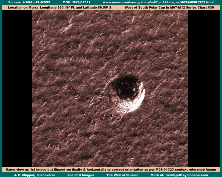
As you can see, while the water hole remains basically the same seen from this different angle, that spiky sort of realistic looking terrain now takes on a entirely different look and one I've seen before. From my experience with viewing true Martian terrain, I regard this look in the second image here as strange. Frankly it doesn't look like real terrain at all. That required me to look even closer and you can too in the closer 182% zoom third image below.
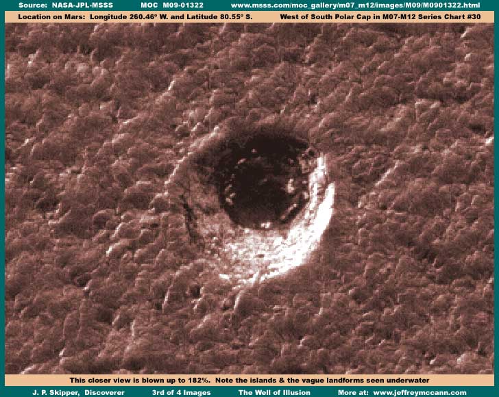
This fluffy lumpy terrain just doesn't look normal and has no parallel for me in true Mars terrain. At the outer edges of the well in the dark ring, I see what clearly (to me) looks like image tampering sweeping back in short bunches of strokes radiating out from the center. This effectively artificially creates the edge of the hole look. You can see some of this best in the above third image but also in the fourth and last image below zoomed in 286%.
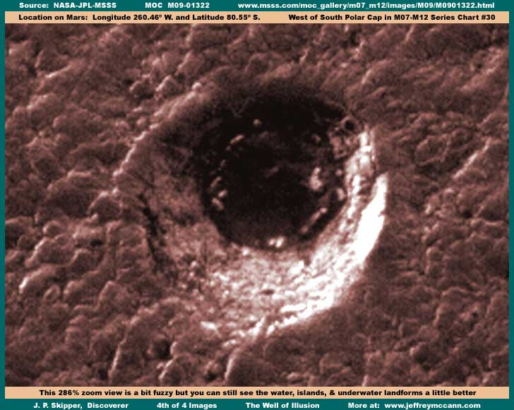
In this image, you can can see the water a little better. Despite being zoomed in too much and a bit fuzzy, you can just barely see that the water is dark but translucent with landforms seen under the water surface. I could have shown the water a little better by putting more lightening and contrast on the scene but that would have come at the expense of excessive glare in the light color area and this would have distracted the eye. Note that these underwater landforms also have projections sticking out of the water around the shallower water perimeter which form light reflective islands. Too much lightening and contrast to give a better view of the water would have made these just glare spots. Note that, while the "hole-in-the-ground" illusion implies a smaller scale, these islands in the water tell a different story of just how large this really is.
But, while water of course is the principle discovery here, it is not the complete picture. In my opinion, this whole darker color terrain around this water discovery right up to its edges is thick carpeting image tampering. Note that none of the "terrain" ridges or upward projections you see here throw shadows of any kind even though the sun is a bit low angled coming from the left and upper left. This is a very telling point and demonstrates that, while this tampering is very good, it isn't perfect. What is really happening here is that the sunlight is coming from the left and upper left and shining on the far side of lines of structures creating light reflections off of the far side and tops of those structures. We can't see the light reflective far side from this angle, only the light reflective tops of the structures. Their near side or shadow side and a portion of the tops has been heavily worked over with a smudge image tampering down at pixel level and the whole then given a uniform color mask to blend in any flaws. This process leaves narrow light bands versus broad dark aspects on each structure to collectively give a poor impression of natural ridges and rough lumpy terrain detail. But, make no mistake about it, it's all illusion!
The only true ground detail here is the light color area that appears to be forming the steep slope of the well hole but is actually more level terrain with blurred but true objects arranged in concentric rings around the water adding to the tapered "in the hole" impression. This light area appears to possibly be buildings but subjected to distancing and blur tampering techniques as well as a lot of contrast to create detail hiding color saturation light reflective glare. The round water and its contents are real and basically left out of the tampering but the heavy dark smudge tampering ringing the outer perimeter of this area is not real and assists in creating the impression and optical illusion of a deep hole in the ground. Obviously, this is why there was no sign of a impact crater as there is no deep hole here, only a large round relatively shallow depression with water in it very distantly seen surrounded by what probably is civilization evidence as judged by the amount of effective carpet tampering.
The distancing technique anchoring all this direct application tampering together into a merged mass is not obvious here because the whole terrain within any meaningful distance of the "water hole" is fake and provides no familiar frame of measuring reference. However, the resulting lumpy terrain itself doesn't look real enough, so they flipped the scene to smooth it out some and give it that more natural level with low spiky sharp ridges look and also tried to make sure that no one would get any different view by flipping all three strips the same way. Only trouble is, they forgot to flip the companion M09-01323 context reference image that gives this away because it is a separate strip and no doubt was simply overlooked.
Therefore, since the water itself is about the only real thing here not subjected to much tampering and as I have repeatedly reported, this demonstrates again that the insider's agenda is to leave all the water they can in the MOC imaging available for discovery and they're willing to go to a lot of effort and expense to accomplish this. As is sometimes the case, the flipped view actually provides a slightly better view of the water itself. This tells me that, years ago when this was all in the planning stages before MGS and MOC ever left for Mars, they may have thought there was at least a chance that the academic and scientific communities viewing these MOC images would be able to break the bonds of their paradigm mindset and find this water. Also, their initial reluctance to release the MOC images at all before finally capitulating demonstrates that they were afraid that those viewing the images might possibly find more than the water and that means civilization evidence as well as the tampering itself which could be the greatest problem for them of all. How wrong they were!
Further, this is true for me as well. I have been holding back major water discoveries since midyear 2000. It was my assessment and my gamble that the academic and scientific communities deeply mired in the click group herding instinct would be too heavily committed to their National Security filtered science data supported paradigm of extremely cold temperatures on Mars of down to –184º F. Such a temperature would of course make water in liquid form quite impossible on the surface of Mars by many times over. Some scientist computer models relying on this science data even reported permafrost 3-miles deep into the planet's mantel as an example of the blind following the blind with too much reliance on plugging what they thought was truthful science data into mathematical models.
Yet it is still hard to believe that ALL these well educated and well intentioned academics and scientists could be so thoroughly self-blinded. So, when some scientist or group announced releases about their discoveries on Mars, I just knew that my gamble had failed and that someone would be coming up with several of my discoveries that I had been sitting on for so long. Yet, incredibly, it has been over a year-and-a-half and still it hasn't happened except for a few things. So, I can't cast any stones at the secrecy insiders for misjudging these communities and the depth of their blindness because I did the same thing myself.
Meanwhile, both the insiders and myself have our own different solutions to this little problem of waking up these communities and ultimately the general public. My strategy has all along been to accumulate and hold back a big pile of water evidence and then spring it all at once in a volume too significant in numbers to be ignored as has so far been done.
This will be in book form and I am in the latter stages of that book development and the evidence record that is core to it even as I write this piece. I regard this strategy as a no choice solution because I have learned from my presentations on the Web that one-at-the-time evidence can be ignored one-at-the-time by these same people who can't currently find any water on Mars. Each discovery is regarded as an aberration and individually ignored and that means none of them are viewed collectively as a body of evidence even though that is what they are. Further, except for some of you who are reading this, the bulk of the slumbering general public so focussed on their own individual everyday concerns isn't about to go to the trouble of hunting this material down. Even if they did, they're not going to take any of it serious unless these same people they apparently recognize as leaders and experts but who can't find anything for themselves on Mars take the lead and say that any such body of evidence may actually have some merit. It may not be logical but it is the apparent human condition and reality.
I could have presented these discoveries in the Internet media portals as I started out doing in midyear 2000 with a couple of discoveries and may yet do that. But, when any media thing happens, everyone wants your attention and there is no time left over for the extremely time consuming hard research work that produces these discoveries must less have a personal life. So I had to stop that early on and get out of the lime light. Now, over a year-and-a-half later and a lot of personal expense later, I have a large body of Mars evidence suitable for presenting and then some. So, rather than presenting each discovery one-at-a-time and having each picked off and ignored one-at-a-time as an aberration, the only practical way to reach the bulk of the population collectively at the same time with a seizable body of collective work is via a book and I expect that to be published within a few months. That book with its many original first discoveries will tie into the website and its discovery record. Between the two, hopefully a general public awareness of water, natural life, and civilization on Mars will begin as well as the pressure to investigate and demand truth in Mars official reporting.
As for the insiders, they have always had alternative plans years in the making to fall back on. In my opinion, the Odyssey probe currently circling Mars is one of these alternative solutions. Unlike the visual mapping of Mars by the early Viking and recent MOC imaging so necessary for the insiders to adequately understand what is really happening on Mars, which inconveniently also turns up evidence they had rather others not be aware of, the Odyssey science methodologies do not have this problem. Unlike visual science data which is a real pain in the butt costing millions to sanitize of objectionable evidence and full of uncertainties about what may have been missed for someone to find, this purer form of statistical science data is much easier to deal with and manipulate to desired ends. With this you can ease into introducing paradigm blinded types to concepts of water on Mars.
First, they start off with the water in water ice solid form concept since this does not immediately conflict with the official temperature science data and therefore gets around the paradigm mindset problem. Then the somnolent science community will eventually begin to wake up and reach the point of acceptance of liquid water gradually reported as new discoveries by Odyssey but which the insiders of course already well know is there. At some point, still unaware of being manipulated, they will eventually reach the turning point and then begin earnestly convincing NASA/JPL, etc. that there may actually be liquid surface water on Mars. REALLY! Once NASA/JPL, etc. allow themselves to be convinced and later with the concepts of liquid water safely adjusted to that they now work overtime at ignoring and denying, then these cutting edge objective pioneers will continue the process of waking up to and discovering the very same natural biological life evidence like the giant plants that they are currently so accomplished at ignoring.
This is the insider's "ease the academic and science communities and thereafter the public into a new age" strategy. It may take 1-3 years or more and during the meantime the civilization evidence is hopefully not a issue in this scenario, the now older MOC imaging with its problem potential is hopefully overlooked, and time is bought. When the civilization evidence does begin to gradually permeate the paradigm consciousness down the road, the distancing of time and excitement of that time as to non-Earth civilizations and the dawning of a new age and epoch for Earth will hopefully leave no room for going back over old Viking and MOC imaging and focussing on its unfortunate tampering that has more unwanted explosive potential than does even the civilization evidence itself. Alternative slight of hand complete! Further, if we buy into it, we have no one to blame but ourselves.
Regardless, just remember, even if you can't see what I'm talking about on the tampering here (it is admittedly hard to identify), don't loose sight of the fact that this is a liquid surface water discovery and adds to the growing body of evidence of LIQUID surface water on Mars.
DOCUMENTATION
http://www.msss.com/moc_gallery/m07_m12/images/M09/M0901322.html: This water discovery evidence is drawn from the NASA/JPL/MSSS original M09-01322 strip located above. My imaging here is drawn from the second listed best quality slower loading not map-projected GIF strip for its better detail but flipped vertically and horizontally to the correct orientation matching the companion M09-01323 context reference image.
Note that this water discovery site is about a third of the way down from the top of the strip in the official flipped view. Note to that all three strips work and have the same not map-projected (not angled & with no border) orientation. However, just remember that all three strip orientations do not agree with the companion M09-01323 context reference image found at the same URL address with the clear implication that all have been flipped at official level. You do not necessarily need to flip the image back to the correct orientation to confirm the water discovery behind me and in fact the official flipped view shows the water itself off to best advantage. But, you will need graphics software to flip the original strips both vertically and horizontally if you wish to try and follow behind me on the investigating the image tampering as described here and if you wish to have the same correct orientation matching the companion M09-01323 context wide-angle reference image I've used here in my imaging.
, Investigator
![]()