
"INCA CITY" RIDGES
Report #036
April 17, 2002
can be contacted at
You should know that the term "Inca City" is not a label invented by me but an identifier attached to this anomaly site apparently by MSSS or some other party. I suspect that this fanciful official label may be a bit of psychology designed to warn so called serious and reputable scientists off from speculating too much as to what these inexplicable and highly anomalous ridge land forms might be.
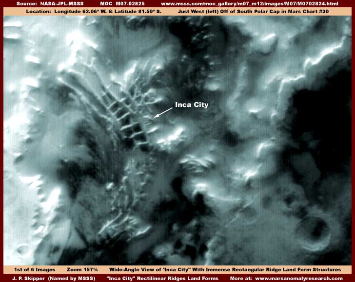
As you can see in the first M07-02825 based image above, these ridge land forms represent fairly straight lines as well as 90º angles and even four 90º angles forming rectangular boxes that interconnect with each other. Most of these ridges are characterized by having sharp peaked tops with very tall and steep sloping smooth sides just as they would appear if they were constructed of loose fill poured down from above in a piled long line. It is hard to imagine that this could be caused by nature but that no doubt is probably the official explanation. You need to specially be aware that the first and second images here are very wide-angle shots. The above first image is a view of about 65 horizontal miles across, if we can believe the image statistics. What ever the true technical measurements might be, these land forms are absolutely immense and you must never loose sight of that perspective as you look at this evidence and have a tendency to naturally think on a smaller more familiar size scale. In other words, think colossal!
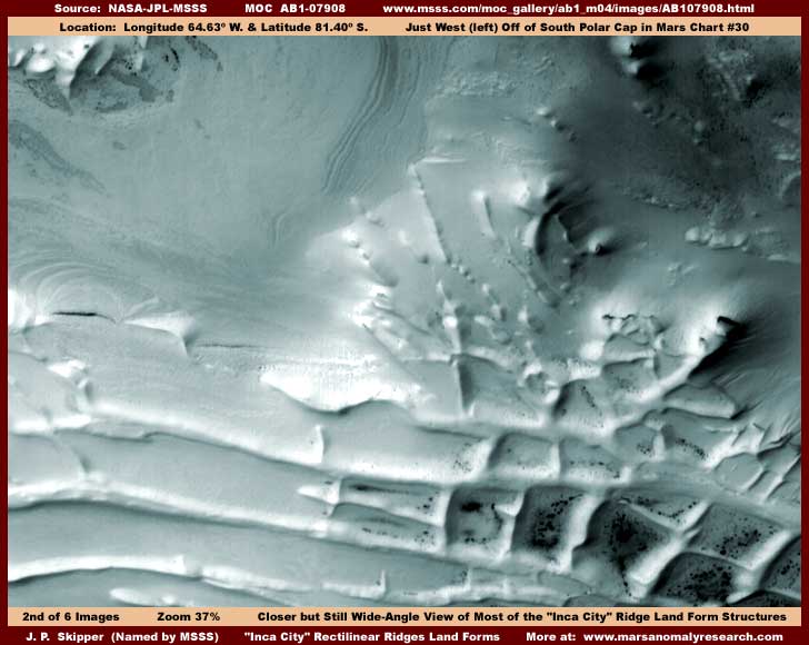
All of the different wide-angle shots of "Inca City" are very distant and would be fuzzy if blown up for a decent closer view. The one exception is the above second AB1-07908 based image from a different narrow-angle strip and I've elected to use it rather than try and blowup one of the wide-angle shots. It shows most of the anomaly site, even if from a different angle, and without getting too blurry. The dark spot speckling you see inside some of the "boxes" is colony life form fungi spore growth that generates in the presence of water in the soil or as snow/ice on the surface but that is a whole different subject that I will be getting into in future reports and particularly in the book that will soon be published.
Also, I've put this cyan/bluish color tint on these images because these are snow fields. Further, a tint like this tends to show more detail differential. You should know that the long open ridge runs on the left are partially covered with snow at certain times of the year as confirmed by viewing many different images of this site. Once you realize that, it then soon comes to mind that these formations may be serving the functional purpose of catching and channeling snow melt water, just on a immense scale. Remember, it's most often all about solutions to water problems on Mars.
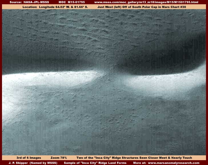
The above M15-01795 image from yet another strip will have to suffice as a representative sample closer view of some of the ridge land forms. I realize that you need more views of these ridges here to give you a better idea of what is going on but there just isn't enough room in this report for more images or it would never load in a reasonable length of time. As it is, it will still be slow to load with six big images. Speculation about Inca City would require at the very least a entire book dedicated to just that and that would be just for starters.
The smaller and shorter ridges around at Inca City appear to mostly be like these two above in being characterized by very sharp peaked ridge top lines (not normal) and reasonably straight lines (not normal) as well as 90º intersections (not normal). Some are arrow straight while others curve a bit and/or have shallow angles in them. The largest main trunk ridge lines appear to have been like this at some time long ago in the past but now are more sloppy and worn with age, the elements, and circumstance. All have the appearance of loose fill being piled up in a long line as though poured down from above, perhaps to cover something and/or form dams or berms serving a functional purpose in the environment. That purpose may very well be catching and channeling snow and its melt water.
Now, as we briefly hit some of the peaks about Inca City, I must include a more tiresome and unpleasant subject. In the above third image, everything looks pretty normal doesn't it? However, this is entirely deceiving and that in turn is purely intentional. The fact is that the shadow side of these two ridge land forms has a application of heavy image tampering that extends out of the shadow a bit into the brighter and more level terrain behind the forms. Further, the solar bright sides of the ridge forms have a light color coordinated foggy blur tampering application all along their lengths. Finally, the foreground plain on the near side of the ridge forms has a lot of color coordinated semi-opaque blur tampering treatment scattered thickly over it. All this tampering has been done at tiny individual pixel level.
If you look very close in the above third image, you can see it for yourself. However, rather than go blind trying to do that or just describe it as I usually do and not waste imaging on it, I'm going to take up some image space here to give you a closer look at a section of the tampering application in the image below.
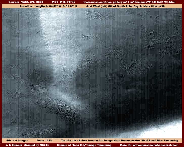
Now look very closely in the above fourth image of a section of the terrain immediately below the view of the third image. Here you can clearly see the otherwise hidden semi-opaque blur treatment applied in this terrain and note that it often follows the straight lines of individual pixel rows straight as an arrow. Where the tampering application is not at, you can also see through the many small windows in the tampering and see what the true higher detail terrain looks like. I have been talking about this kind of tampering for long months now trying to prepare some of you without backing it up with hard evidence because I didn't want to waste images on this (still don't) and also felt that some viewers will need a disbelief back door to escape out of occasionally when the going gets too complex and uncomfortable to deal with but now I think many of you will be able to see and handle this.
Through these small windows without the tampering, I believe we are looking at thousands upon thousands of buildings down in the giant more level basin area inside one of these ridge land formed boxes. The solar bright top edge higher ground of another ridge can be seen starting in the lower right corner. These are probably smaller size buildings in residential areas reduced to a tiny indistinct jumbled terrain look by the distance tampering while the larger and would have been more viewable commercial and government buildings are being covered up by the object specific blur tampering. This also demonstrates that, despite the familiar looking apparent scale in the third image here of two ridges, what we have really been looking at is very distant (the by design distance tampering) and only looks normal size because of the sheer colossal size of the main ridge objects involved. It is just more of the secrecy insiders visual slight of hand manipulating our perceptions.
You can see the undeniable blur tampering for yourself now and most of you should know by now that they are not going to this trouble to cover up rocks, water, or vegetation. So try not to give in to the temptation to rationalize that what you are seeing here in these small windows is just some rough rocky terrain. Although we admittedly can't see and identify individual building objects at this far too distant resolution, it is almost certainly densely packed buildings, just seen on a very tiny scale. This is typically the objective of such image tampering and, further, what else could be worth the tampering effort? For comparison, I suggest that you keep a sharp eye out for background city images on TV that are occasionally shown. You will see that suburb residential areas around much taller city centers look very similar to this seen from just nearby hilltops or aerial shots must less the kind of extreme distant satellite imaging we are looking at here.
I know that some of you that can face this will still find this kind of hard evidence of outright tampering uncomfortable to contemplate and a little intimidating as the subject of great populations on Mars moves from a safer theoretical concept in your head toward actually being factual, real, and consequently a little more scary. This is a perfectly normal reaction as some of you come to the point of actually considering that we have all been living in pretense for no telling how long as to the real environment that we already live in. Just don't worry, if anyone on Mars meant us any harm, it would have happened long ago. The fact is that we have more we need to fear from our own human idiosyncrasies than from someone else's intentions toward us. We've all got to face up to the fact that a new age is already here upon us and we've just got to get up nerve enough to take the next step and wake up to the real situation we already live in.
Believe me, ignorance and pretense are not good things! The alternative is that you must be prepared to subjugate your own responsibility for yourself, your knowledge level, and your children's future to trusting in the ivory tower decision making of the secrecy insiders operating in a vacuum without any checks and balances input from you! You must decide what is important to you.
I can tell you that the surface of the Inca City general environs is relatively free of any obvious civilization evidence. This is mostly because the distance involved is far greater than it appears reducing everything that isn't giant size to a tiny speck. So, you haven't missed anything by not looking at a bunch of different ridges here. They basically all look similar as the fill mountain lines they are with newer ones being relatively straight, steep sided, smooth, with sharp peaked tops and older main trunk lines being lower, more round, settled, and worn looking. Some of the older ones even show evidence of fill partial slippage sections just as with sand dunes or snow banks further demonstrating that this is indeed piled up loose fill material.
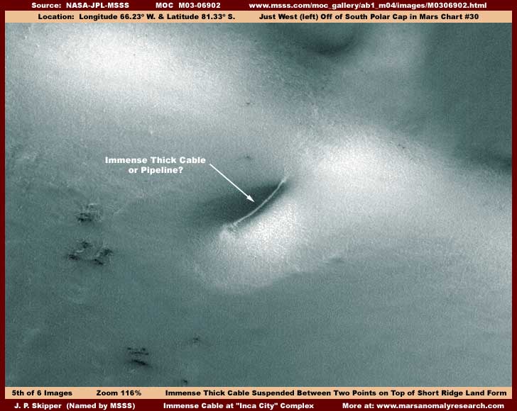
However, there is one glaring exception as the above and below M03-06902 based fifth and sixth images here from yet another strip show us a short ridge land form sticking off the side of a main trunk line with what appears at first blush to be an immense thick cable suspended between two points. Remember the distance involved and the fact that this object is huge even though it appears in first impression to be normal size. A twenty story high rise building would be so tiny here that it might not be visible at all up beside this thing to give you an idea of scale regardless of what MSSS measurement statistics may say. I have no knowledge of what this might be? One thing is clear, it is not likely a natural object but something artificial. Perhaps it is a immense antenna for extremely long range communication that must necessarily be above ground and is designed to be as inconspicuous as possible? On the other hand, it may be nothing more than a huge bypass transfer pipeline temporarily on the surface?
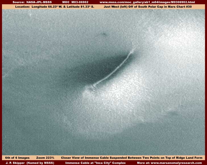
The above closer view really doesn't help very much in resolving what this might be but I knew you would still want to see it. The brightness of the terrain implies snow or ice but I don't really trust that very much considering the demonstrable tampering elsewhere in these strips. I do know that the slight smoothed but also knobby texture of the surface can be fabricated but have no idea whether that has been done here or not. I will say that the terrain around this object looks color over-saturated and a little too suspiciously uniform and featureless to me. Remember, we are dealing with others here who can zoom in very close, do their tampering thing, and then back off to the point that everything (including tampering imperfections) blends in together into a distant indistinct mass that is very effective. Only the largest giant objects here like this anomaly partially survive such treatments.
In any case, the main question in this report is about the colossal ridge land forms themselves. Are they natural or artificial? In my last report #35 arising from image strip M12-00441 of the partially exposed "Buried Tube System" found HERE involving a similar filled and peaked ridge land form covering what I believe to be a huge triangular shaped tube system supports the concept that underground civilizations exist. So, you can no doubt anticipate my opinion that these very similar ridge land forms are artificial constructs. I suspect that the "Inca City" ridge land forms are just much older and clearly on a much larger immense scale than that seen in M12-00441, which are themselves huge. I suspect that the Inca City ridges represent artificially piled long lines of fill the size of mountains covering underground civilization evidence possibly similar to that in M12-00441 as well as serving the practical function of catching, channeling, and holding snow and snow melt water in sizable amounts.
Also, despite surface appearances, I don't think there is any question that there is also substantial civilization evidence on the surface as suggested in the image with all the tampering here, not because we can actually see the buildings (we can't) but because of the presence of all that image tampering that normally always hides this kind of evidence in the MOC imaging. It is just that it is not readily evident because the colossal size of the Inca City ridge constructs allows whoever is doing the tampering to effectively use the distancing technique to draw away from this area far enough to force any civilization evidence into being too tiny to be seen adequately.
That way, although the ridge land form structures seen from afar look highly anomalous, the closer but still strictly surface examination one normally gets to make in the official resolutions provided in the science data reveals nothing particularly anomalous at all and you leave "Inca City"shaking your head thinking that Mars is truly a different and strange place with some interesting but inexplicable "natural" wonders. Of course you never realize that you never got a decent close look at anything at all due to the distancing technique slight of hand that capitalizes on the human tendency to force size visuals into more familiar even though false sizing when no adequate comparison frames of reference are present.
The fact is that Mars is very similar to Earth except older, colder, and with considerably less water and atmosphere. Those exceptions have forced different life adaptations both for natural and civilized life and it is the life adaptations that are so unfamiliar and strange, not the Mars natural processes. The trick is to break through the paradigm blindness, understand the visual slight of hand tampering treatments, and learn to identify the life processes from the natural geological processes.
This combination of distance and object specific tampering is generally very skillfully done here. However, the shape of the piled loose material fill ridge land forms themselves and their sheer size, the first information key for understanding the presence of underground civilization evidence provided in previously reported strip M12-00441 combined with the presence of the relatively crude object specific pixel level tampering and even to some extent the highly anomalous suspended cable looking anomaly, all combine to point in a different direction than that desired by whoever is doing this tampering and trying to manipulate our perceptions. The only question then becomes, do you have the courage to explore the path of truth and meet head-on the destiny that is already yours or will you let others dictate yours and your children's fate?
DOCUMENTATION
You can confirm at http://www.msss.com/moc_gallery/m07_m12/images/M07/M0702824.html the M07-02825 based image evidence appearing first here in this report. At the MSSS site, choose the wide-angle context image on the right in any of the three available strips. All work and all agree on orientation.
You can confirm at http://www.msss.com/moc_gallery/ab1_m04/images/AB107908.html the AB1-07908 based image evidence appearing second here in this report. At the MSSS site, the single front page image will serve that purpose but so to will any of the three available strips. All work and all agree on orientation.
You can confirm at http://www.msss.com/moc_gallery/m13_m18/images/M15/M1501795.html the M15-01795 based image evidence appearing third and fourth here in this report. All three strips work and the first two agree on orientation. The third has been flipped but also offers a much larger view than the first two.
You can confirm at http://www.msss.com/moc_gallery/ab1_m04/images/M0306902.html the M03-06902 based image evidence appearing fifth and sixth here in this report. The first and second listed strips do not work and there is no MSSS front page image either. However, the third listed strip works and may be flipped but is the view angle that I've used here.
As you will find, all this evidence is found in and fully supported by the NASA/JPL/MSSS official science data even though of course not by those organizations themselves, who have so far ignored this work. Nothing has not been altered in any way by me as my imaging is limited to enhancing detail only. If you are interested in a more thorough examination of the "Inca City" site for yourself in the science data, the following is a list of some image strips for your convenience in using.
AB1-07908, M03-06902, M04-00678, M07-01552, M07-01904, M07-02824, M07-03428, M08-02675, M08-04693, M08-06508, M08-06605, M09-00012, M09-01860, M09-01934, M09-02534, M09-03813, M09-03965, M09-05442, M09-05545, M09-05894, M10-01405, M11-01803, M11-02076, M13-00047, M13-01779, M13-01966, M14-00267, M14-02193, M15-01795, M16-00825
As you can see, someone is obviously very interested in the "Inca City" site and the above list of 30 images is no doubt not all that are available, only those that I happen to have come across. Good Luck!
, Investigator
![]()