
LIFE INVADES HUGE MOUNT
Report #41
DOCUMENTATION: MOC E02-01521
July 27, 2002
http://www.msss.com/moc_gallery/e01_e06/mc25.html
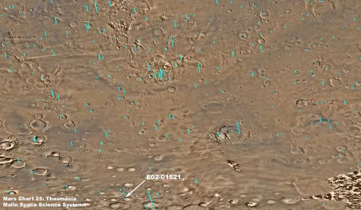
Should you wish to access the E02-01521 discovery evidence via a graphical browser interface, the MSSS Mars Chart 25: Thaumasia image represented above is the best and located at the above URL address.
http://www.msss.com/moc_gallery/e01_e06/images/E02/E0201521.html
The above MSSS (Malin Space Science Systems) link will take you directly to the desired E02-01521 official science data image. The first two strips are sinusoidial (angled) JPEG and GIF while the third and fourth strips are straight vertical JPEG and GIF. All work and all have the same orientation. The companion wide-angle E02-01522 context strip is also at this same location.
http://www-pdsimage.jpl.nasa.gov/PDS/public/Atlas
The only least complicated but describable method I know of to access a specific MOC image at PDS is to go through a search process from their "Planetary Image Atlas" page at the above link. On that page in the first Mars Global Surveyor section click on "Forms Search Interface" under Data Access Links. On the data search page that comes up enter the Latitude coordinates -63.05 (don't forget the minus sign) in the top left and right fields and right under that the Longitude coordinates 99.41 in the left and right fields. Do not enter any other information in any other fields and then click on "Submit" down at the bottom of the page. The next page that comes up will have a pop-up window which you should close and then click on "View Thumbnail." That will bring up the true E02-01521 browse page. On that page you can use the default GIF image or chose from other imaging formats. You should know that the GIF image here is actually a BMP file, the strip is very dark as to obscure almost everything, and it is flipped both horizontally and vertically. So, if you use the PDS imaging, you will definitely need graphic software to correct these problems.
As for the USGS website, it does not yet to the best of my knowledge have the newest E01-E06 image sets available on its search pages and you will not be able to use that as of the date of this report.
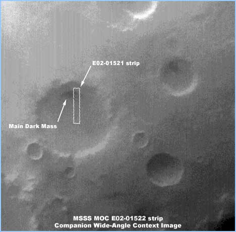
The above is the companion E02-01522 wide-angle context image strip showing the location of the narrow-angle E02-01521 strip within it and also within the crater you see. The small dark shadow at the north end inside the crater is the location of this life evidence around and on the water ice mass. I might add that this is very often the location of these ice masses inside craters, although they can also be at other locations inside the craters as well as out in open terrain. As you can see, the E02-01521 strip only catches a little of the east end (to the right) of the mass while the bulk of the mass is just off the west edge (to the left) of the strip. This strip also confirms the correct orientation of the narrow-angle strip. The MSSS strips all match this orientation in this particular case while the PDS imaging does not confirming that the PDS image has been flipped.
, Investigator
![]()