SHAPED, FITTED, & NESTED ANOMALIES
Report #043
September 23, 2002
can be contacted at

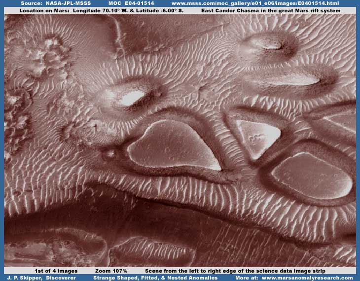
This scene is down deep in the bottom of the East Candor Chasma, which is a northeastern branch of the great deep rift system on Mars. In the above first image from strip E04-01514, the scene presented is all the way from one side of the strip to the other. It's too bad we couldn't get a wider look at more of this site to the right of this scene. As you can see, these anomalies give the impression of being shaped, fitted, and nested together and are very strange and highly anomalous to put it mildly. Their well defined shapes and the impression of being fitted and nested together is very suggestive of artificial influence. Further, the way the densely packed light color ridge lines are clearly oriented on these anomalies makes them even more strange and anomalous. The first and natural reaction is to try to interpret them in terms of some form of strange natural geology. So what are these things?
Note the way each anomaly appears to be a depression containing a center area that is flat and level and this area even appears to give off a light reflective sheen sort of suggestive of wetness. When I first discovered this site months ago, I thought at first that I might be looking at huge ponds of water. However, I quickly ruled that out because of the obvious textures, patterns, and grainy quality in the flat level interior spaces and lack of sufficient transparency that can be seen at even the normal science data resolution. Still thinking in terms of their being just what they appear to be, well defined depressions, I then thought that this might be hardened geological lava mud of some kind in the depressions but then I began to look a little closer and fortunately this strip is one of the rare ones that will allow a reasonable closer zoom view.

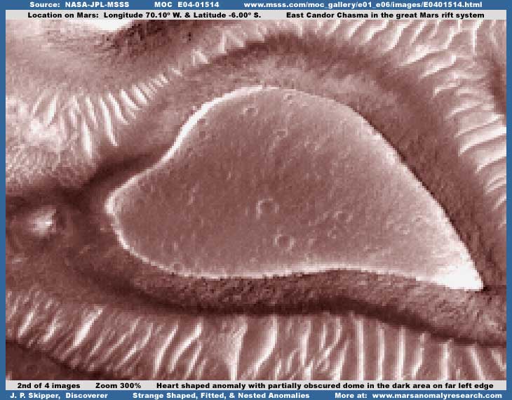
The above second closer 300% view of the vaguely heart shaped anomaly tends to reinforce the depression appearance. However, the medium dark color collar/rim/border around the flat level center area was now recognized by me as a type of image tampering that I have seen often on the South Polar Cap also forming a collar around flat level center areas that also demonstrate a textured and patterned surface quality that, in conjunction with other techniques, I've come to associate with "creative" type image tampering that creates appearance illusions. Take note of the light color ridge lines radiating down below the heart shaped anomaly as well as those bordering the upper left of the anomaly. Note how these lines are beginning to demonstrate jagged edges at this 300% zoom while other object areas in this scene are not demonstrating these jagged edges at all. I believe that these light color lines have been selectively subjected down their length to a object specific offset pixel blur tampering technique that produces this blurred into indistinctness result and the exaggerated jagged edge appearance.

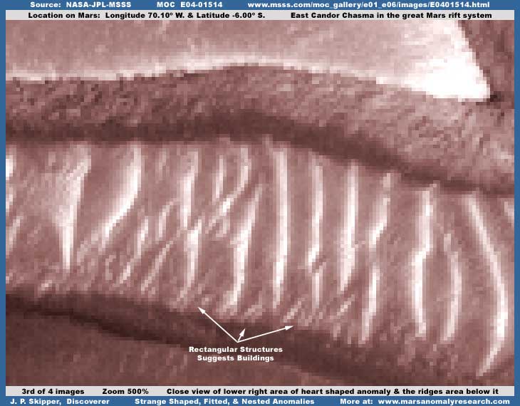
The above third image is increased to 500% zoom of the lower right portion of the heart shaped anomaly level center area and the light color ridge line terrain immediately below it. As you can see, the level center area of the anomaly begins to resolve into a jumble of diffuse vague geometric patterns that is suggestive of image tampering and not any kind of real planetary "surface" at all. Also, the darker collar area is resolving into a similar appearance with the tops of vague geometric forms sticking out of it. Significantly, neither look is consistent with any kind of natural terrain geology at all and that is a telling clue. It's because this is artificial image tampering covering something in these locations and as such looks like nothing natural at all when the closer look reveals fine details not seen at the official supplied resolution. Likewise, the larger light color "ridge" lines are now heavily blurred into unrecognizable indistinctness as are the darker terrain interspace areas between them where the tampering application on the "ridge" lines overlaps at its outer edges in these areas and doubles the obscuring effect. However, some small areas at the bottom of these light color rows are not as badly effected and, if you will get down close to the screen and examine very closely, they clearly resolve into geometric rectangular structures and rows of structures, none of which are found in natural geology and all of which are highly suggestive of artificiality and building structure evidence.

The above fourth image is of an area of terrain immediately below the scene in the third image here. Again the light color rows are heavily pixelated and the terrain around and among them has an additional thickly applied dithering pattern of dark color fog image tampering completely covering and hiding everything there. However, you can be nearly perfect with such applications, especially when they are done by good computer software, but perfection itself just doesn't happen in any practical way in the real world. Accordingly, you can fairly clearly see the much larger and taller dark rectangular structure with its perfectly linear vertical lines sticking out of the middle of this mass of light color "ridge" lines that I've pointed out with an arrow in the upper part of the image. It to is partially obscured with the pixelization treatment but its shape was simply a little too large to be completely obscured. This is very suggestive of a building and therefore civilization evidence. Also, in my opinion, although heavily blurred by the base pixelization treatment, the entire oval area below in the lower half of the image at the foot of the light color rows is likely a city landscape as pointed out with my labeling low in the image with many high-rise differing height building structures but it is heavily blurred and so you must decide for yourself about this. If nothing else, this tiny evidence seen only at the substantial 500% zoom and in the periphery areas out from the main anomalies, which we now begin to understand are gigantic, will give you an idea of the true size and distance scale involved here.
Now look back at the first and second images here. In my opinion, the strange anomalies that looked so much like well defined but strange geological depressions to start with at normal science data resolution are not depressions at all when picked apart in fine detail at maximum zoom. They are in fact nothing more than false illusions intentionally created by some "creative" image tampering and I suspect this was used to completely blot out some kind of larger scale civilization evidence in these areas.
In my growing experience with Mars civilization evidence and the tampering that always comes with it, I've learned that buildings in big civilization centers on Mars sometimes take the form of many parallel lines or rows of light color buildings with darker structures located in between them. I can not explain why this is so, only observe it. Of course I can not know for sure because of the effectiveness of the tampering but I suspect that the many light color parallel heavily pixelated ridge lines seen here are actually rows of very large tall buildings radiating out from center hub metro areas of even larger to giant size taller buildings. I suspect that the image tampering first completely blots out this metro center hub area with a fairly uniform tampering coating that gives the flattened appearance and then the darker collar/rim/border tampering is applied to give the appearance of this being a elevated border around a depression. In other words, misdirection giving the impression that it is the exact opposite of what it really is. I have also seen this technique used on craters to hide evidence around the periphery rim and at the same time create the illusion of depth when the crater isn't deep at all.
In this scene in the E04-01514 strip, the real telling evidence to get at the truth is not with the main giant, strange, and dramatic looking anomalies themselves that naturally receive our focal attention but in the lesser terrain around them that would normally be dismissed but which has received a bit less tampering treatment and offers a little better quality evidence. Once the outer area evidence is better understood, then comes a sense of what one is really looking at as to size and scale and that is when understanding really begins. It is for this reason that anyone researching the Mars visual science data must take the reality of image tampering into consideration. If not, interpretations wind up being just what the secrecy insiders have designed them to appear to be, which often has little to do with the true Mars reality.
Before closing, you should be aware that the vaguely heart shaped well defined depression looking anomaly site imaged here and the scene a little more to the left (west) of it appears in two other MOC image strips M23-01434 and M01-00068. Although decent images, they are primarily limited to showing the heart shaped anomaly only and cut off the scene further to the right (east) of it. This eliminates the wider view demonstrating the shaped, fitted, nested, grouping effect seen in E04-01514 and so these other two images do not really offer any more information than this E04-01514 strip.
DOCUMENTATION
http://www.msss.com/moc_gallery/e01_e06/images/E04/E0401514.html : This link takes you to the official MGS MOC E04-01514 raw science data image strip from which the evidence here in this report was sourced. At this MSSS location, suggest you use the second listed faster loading JPEG strip for convenience in just confirming the basics of the anomalies and their being there. However, to see more in the form of the tiny distant detail similar to my 2nd through 4th images here, you will need to download the third listed slower loading GIF strip for its higher detail (has the same correct orientation) and use graphics software to zoom in to the 300%-500% level and to clarify and sharpen up the scene for the real evidence.
, Investigator
![]()