
THE HAND OF POWER
Report #059
January 19, 2004
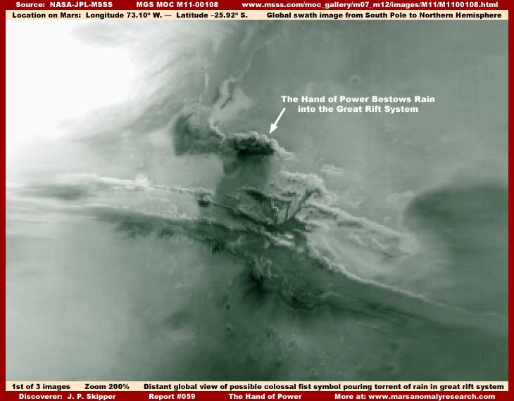
The above striking first image is of the Coprates Chasma Region on Mars. This is the great rift or crack system deep in the planetary surface in the middle hemispheric area of the planet stretching east (right) and west (left) in the region. I've arbitrarily given it this general coloration as opposed to a more normal reddish hue associated with Mars because in my opinion this color provides the best contrast between the different objects demonstrating a little more detail and it just happens to also have the additional plus of being very nice looking as well. However, just remember that it isn't likely a realistic color.
This view differs considerably from the normal narrow or even wide angle MGS MOC imaging and should not be confused with them. That's because it is isn't drawn from them. This scene is in fact a global view of a wide planetary swath of the planet's surface extending from the South Pole up partly into the Northern Hemisphere with this scene falling in the middle area in the Southern Hemisphere just below the Equator. The very distant view combines with the ever present image tampering to give this imagery its overall cloudy fuzzy quality and lack of very much detail. Only the absolutely super colossal size of the phenomenon at question here is overcoming to some extent these visual limitations.
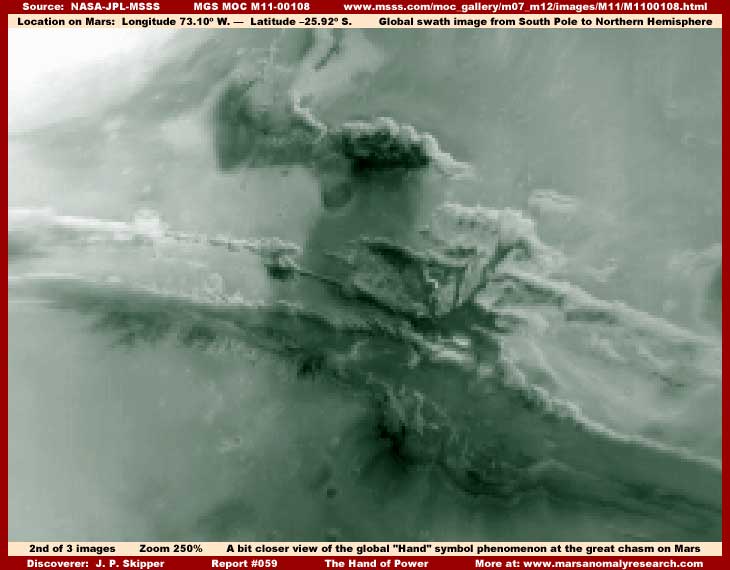
The second image above provides a bit closer view. What you are seeing here, if this side of the planet was facing you, is a view that would be growing larger and larger and increasingly making itself known to you if you were approaching the planet from space long before you came to the planet's outer atmospheric boundaries.
Unless you were blind or seriously dense headed, this mesmerizing possible symbol on such a immense colossal planetary scale would be causing you to seriously question any preconceived ideas you may have had as to whether this planet has been occupied before or at present by some seriously advanced intelligent form of life. Yelp, as you approached the planet from space, you would be getting some deep uncomfortable feelings deep in your guts about now. Obviously, if this is artificial symbolism, then it gives "COLOSSAL" a entirely new meaning.
This looks roughly for all the world very much like a suspended hand attached to a disembodied forearm closed into a fist pointed downward toward the planet's surface with a torrent of rain water pouring out of the "Hand" into the north central area of Coprates Chasma. You'll also note that the Chasm looks considerably different here than in closer views such as in the third image below. The distant poor resolution combined with haze and smudge tampering is very thick here in these first two images obscuring most everything except for some basic outlines.
Further, when you think about it, such extensive tampering is itself very provocative and suggestive of what incredible evidence might could have been seen here before these application treatments. The "Hand" shape may have been left out because the automated tampering software didn't recognize this shape as anomalous and/or humans would have no doubt correctly thought that this symbolism is just too fantastic to be recognized.
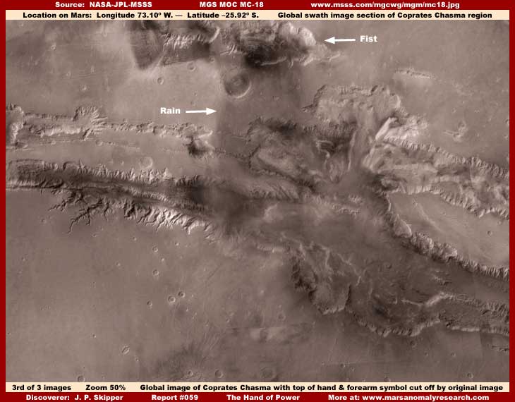
The above third image is a much closer but still wide regional view of this same scene and the main area of Coprates Chasma. This demonstrates that this "Hand" and "Rain" imagery is unquestionably a function of land forms, surface topography, and topography coloration as you see above. Beyond this point of view distance, as you move closer and closer, the unique visuals blend more and more into the land topography becoming less recognizable eventually to the point of not being recognizable at all.
So the big question is whether this symbolic imagery is a function of chance "natural" formed land topography or is it a function of intentional artificial creation manipulating land topography, just on a unbelievably colossal scale?
Once the relationship with the land topography is understood, most will assume that this distant view symbolism is just a chance configuration of natural land topography like clouds in the sky or natural land forms here on Earth on a much smaller scale that sometimes take sort of recognizable shapes. Truthfully, I cannot answer this question definitively and will not pretend to do so. What I will express is some points and questions of my own that I think are germane to any consideration on this subject.
First, the entire scene in the above third image is very heavily obscured by many different forms of heavy blot out image tampering. This includes all broad higher elevation land areas right up to the top edge of the chasm drop off as well as the bottoms and bottom sides down in the chasms. The only thing not tampered with as much is the top areas of the eroded gully systems. So much visual truth other than the Hand of Power symbol and the basic depths of the chasma are missing from this scene.
In the first two images here, note what appear to be strange dramatic dark slender projections of some kind on the right bottom side area sprouting up at an angle from the base area of the column of "rain" and how these seem to be elevated forms in the more 3D global imaging. Now in the third and different closer view "topography" image above, note how these projecting forms at first appear to be missing. However, the image tampering is very thick in this particular third image and closer examination reveals that smaller parts of them can be seen sticking out of this tampering. The tampering application as a coating acts to destroy the natural 3D effect of the visuals and thereby any possible appearance of elevation.
Now this doesn't necessarily mean that the elevated appearance of these forms in my first two images here is the reality. The distance is too great to be conclusive about that and the thick obscuring treatments in the global imaging could have created this elevated effect in the process of hiding something else there around them. Never forget that.
For example, fictionally speaking, if there had been a colossal massive dark color structure there, even I with my limited graphical skills could have digitally applied this light color cloud looking smudge tampering coating all over the structure flattening and destroying its 3-dimensional quality and leaving uncovered let's say (fictionally) only the dark lines forming a imaginary cross shape with the result of this then appearing to be the illusion of a cross object suspended in the air.
However, as my research has pointed out over and over again, image tampering's presence in this satellite imaging is consistently associated with obscuring in general life and in specific civilization evidence. That in turn is very suggestive of what really may be here under all that tampering. If there is extensive civilization evidence in this area colossal in size enough to be seen at all in the MOC "global" swath imaging, that would obviously have a significant impact on the question of natural vs. artificial origins of this "Hand of Power" and torrent of rain symbolism.
Likewise, such extensive image tampering may also bring up the question as to whether the tampering itself has intentionally or unintentionally helped create the forearm, hand and rain visuals and thereby helped create an "illusion" like this? Could be and I can't say definitively.
On the other hand, such a colossal rift or crack system when it was formed no doubt in the ancient past forming a long pit extending deep down into the planet's surface, would have drained any above and/or below ground water in existence at the time in the region for many hundreds of miles around into this place and may have also once acted as a tremendous repository of that water. So, this great rift system in its long geological existence may have been just as much about water accumulation on a colossal scale as about its geological depth. Yes and here we just happen to have imagery appearing precisely right in the center of the geological system and also precisely oriented "above" the system unmistakably conveying a message about water pouring into the system. This would seem to strain coincidence rather considerably to me.
So is there any evidence of water at the base of this falling column of rain? As a matter of fact I have previously reported on water in this locale in my report #011 titled "Water, Island & Civilization Evidence" back at the end of the year 2000. The official image for that evidence is heavily occluded with a thick haze streaking over the entire image but careful examination reveals a wide body of shallow water complete with islands and even some faint civilization evidence.
Also, someone on this planet has had a penchant for doing things artificially with land topography and on a grand colossal scale. As an example, consider the colossal head and animal monuments seen in my report #003 titled "Colossal Head & Animal Monuments." The head is so large at some 12+ miles across that it can only easily be seen in multiple strips of the MOC wide-angle context imaging and is much less apparent because it is so colossal in size in the much closer narrow-angle imaging.
As an example of this issue of size vs. perception, consider this. Most of us are familiar with distant images of Earth taken from orbiting satellites hundreds of miles out where you see this beautiful big round globe. The point is that you can visually encompass the full round global perimeter of the Earth. Now take the planet Jupiter and position the satellite camera the same few hundreds of miles distance as we did on Earth from its surface. The resulting view would be more like a continuous straight wall extending up, down, right and left because that planet is so much larger in scale than Earth. If you didn't already know better, it might even be difficult to accept that you were even looking at a round planet from a point hundreds of miles out from its surface. Everything is relative perception wise.
On Mars, it certainly isn't like artificial manipulation of land topography on Mars on a super colossal scale such as this should be considered unlikely or impossible. There is other visual evidence of this on the planet as pointed out by the above link to report #003 of the colossal head monument. This Hand of Power symbolism may just be the biggest one of all. If it is considered just too incredible to be true, that is just a human incredulous psychological emotional reaction as opposed to rational examination of observable facts. Just because humans on Earth don't or can't do this, that doesn't mean that other more technologically advanced life forms with different viewpoints would not do this on another planet. Feelings based belief systems are unreliable as a basis for interpretation of evidence that falls too far outside of our psychological accepted norms.
The point is that such psychological assumptions based on no real facts can be very premature and we should at least be careful and objective about this rather than carelessly throwing the baby out with the bath water. Remember, the danger of this type of thing is that today's careless assumptions can eventually become so entrenched that they become tomorrow's accepted paradigm mindset that can blind us to true realities that don't fit our preconceived perceptions very well.
In any case, I thought I would bring this striking looking phenomenon to your attention as something at the very least of interest. Certainly the science community has seen this and of course as usual immediately dismissed it via their paradigm mindset assumptions. It's just natural land forms and that the end of it! I think making any such assumptions on this is a mistake and I think that we should all keep a much more open mind as to evidence like this and what it could potentially mean. Being careful not to prejudge based on ones feelings can be an excellent step in mitigating future risk of all kinds.
DOCUMENTATION
http://www.msss.com/moc_gallery/m07_m12/images/M11/M1100108.html: This link accesses the official MOC science data global swath image from which my first two images here are drawn. Except for some general color I've added for better contrast, a increased zoom factor for a closer view, and cutting through some haze for increased clarity, you will see that my images and the official science data are the same.
http://www.msss.com/mgcwg/mgm/mc18.jpg: This link accesses the official MOC science data global imaging of the Coprates Chasma system and the region that surrounds it from which my third image here was drawn. Note that the view of this region that will come up is much larger in scale than my image here. I reduced the original by a 50% factor to get the Hand of Power and chasm scene to fit into my smaller imaging frame size for this report.
, Investigator
![]()