
SPIRIT ROCK & TERRAIN
EVIDENCE
Report #060
February 1, 2004
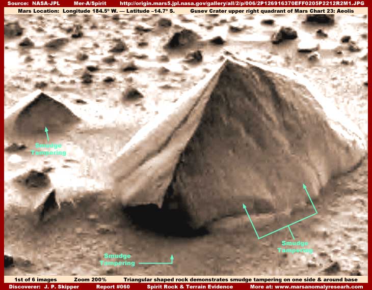
In the above first image from the Spirit panoramic camera you're looking at a larger rock and a much smaller rock to the immediate left of it. These objects are just a few feet away from the lander/rover. Note that both are curiously peak shaped and, except for size, are very much alike in their roughly triangular forms. I have no idea whether the shape similarities are a significant factor here or not but it is enough of a curious and interesting similarity to point it out to you.
In my opinion, what is more significant evidence wise in this scene is the presence of featureless smudge image tampering layered on the shadow (right) side of the rock faces as well as in the terrain around the base areas of these rocks. I also suspect that the back side of the large rock that we can see also has a surface treatment of this smudge tampering applied to it. It is just that the stronger light reflectivity on the back sides obscures it. Very close examination of these areas of these rock surfaces reveals it for what it is.
The question here then becomes whether these tampering applications hide some specific kind of evidence in this close ground to ground imaging, as is often the case in very distant satellite imaging of Mars, or do the applications primarily serve a more general and/or combination purpose? We'll get to that in a minute after absorbing some more information presented below.
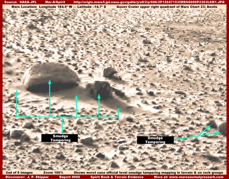
The above second image is a little wider view of a different area of the terrain. It is also just a few feet off from the lander/rover and this image demonstrates both the rocky field in general and some different larger rock groups. In this scene we don't have to get as close to targeted anomalies to recognize the treatments on them. For example, on the largest rock group center left, note the very clear and very obvious smudge and blur treatment on the largest rock mostly but not quite covering all of it.
Also note the second largest rock immediately to the right of the largest rock. The shape of this heavily blurred object as demonstrated above should be compared with its shape in subsequent images below. When done, you will see just how much this object's very angular form and projections in this image has changed. In the above view, its blurred shape is very angular with apparent dark rectangular openings in it and quite suggestive of possible artificiality which is mostly hidden by the tampering. In the subsequent views below, the object changes shape in stages and transitionally becomes just another rock, albeit with a strange rectangular hole still appearing as above in its left side or end.
Please also note that there are two close together but still separate objects on the right edge of the image that are completely covered and their true form completely obliterated by dark smudge image tampering. These two objects in the next third image below, even though still with some obvious image tampering on them, will also be seen to transitionally change in shape to appear more like rocks.
Likewise, very important, note the rather heavily done smooth smudge tampering in the terrain immediately around the base area of the largest rock group. You are not looking at soil or sediment as it may at first appear. Although I didn't have enough image room to include documenting it here visually, zooming in on this along and along all the way down to individual pixel level demonstrates that it is featureless combination blur/smudge tampering application with a blur transparency to it rather than natural hard surface material and devoid of any natural hard surface information detail at all.
Once one begins to understand this more obvious terrain finer soil/sediment mimicking application for the tampering it is, then the same zoom in testing reveals that almost every tiny space between even the small rocks in this terrain have been subjected to the same hard to detect treatment. In other words, in a process very similar to the distant satellite imaging described in my previous reports, the tampering software maps to the tiny lowlands with featureless coating applications eliminating most all small natural detail leaving the highlands (rocks) with less tampering on them and of course more detail and more visible. The net result at the normal resolutions officially supplied is a relatively natural looking environment where the dense but scattered rock field detail draws the eye and attention away from the soil/sediment tampering applications.
Examining many of the Spirit raw images reveals this type of rock and terrain tampering applications is universal in all the terrain shots and not unique to the representative sample scenes presented here. Close examination of what appear to be soil/sediment dunes both smaller and larger in other images not presented here reveal the same and that they are either complete fabrications or real dunes covered with blur/smudge applications. The list goes on and on like this in the Mer-A/Spirit imaging.
Very similar to the distant satellite imaging, this kind of mapping tampering is made possible by much closer imaging than is being released for public scrutiny. In the more distant satellite imaging, the trick is that the tampering is done at very close resolutions kept secret and then one draws back to a more distant but still reasonable resolutions released to the public. Anomalous normal size individual evidence is reduced to a really tiny size sufficient enough to blur and merge together forming new and different joined shapes and then the resolution statistics as officially reported are manipulated to fit this scenario. The only things that overcome this particular most often used tampering technique are really huge to colossal size objects that are too large for this to be very effective on.
Where this particular procedure dominates (there are different procedures & combinations in different strips), evidence of this in so many official science data images can be demonstrated by examining both the official Internet browser compatible .JPG and .GIF image file sizes that are most often used and comparing them against the file sizes of the non browser compatible .IMG and .IMQ true official science data images that the .GIF and .JPG files are derived from.
The .GIF (more detail) and .JPG (less detail) files are substantially compressed formats with a reduction of information detail in them. Note also that it is conveniently the smallest detail in the strip that is the most negatively impacted by this compression. Thus the artificial distancing forcing anomalous evidence to a tiny size along with the most often used browser compatible compression imaging formats effecting small evidence the most combines to insure that this kind of evidence will not be seen or at least will be too small and too blurry to be recognized.
In comparison, the original full resolution raw .IMG and .IMQ true science data files should be many times the size of the compressed .GIF or .JPG files but are often either the same size or only a bit larger and of course offer no significant increase in information content. This is direct conclusive evidence that the even the science data files as released for public consumption have been manipulated and do not represent the true raw full resolution images no matter what format they are in. Otherwise, if this were not the case, someone could see something anomalous in the browser compatible compressed imaging and could then get a closer look at it in the .IMG/.IMQ imaging that should supply a much better closer look at the smaller detail. We can't have that now can we.
Yet, incredibly, this simple revealing comparing file sizes fact in the satellite imaging science data appears never to be contemplated by mainstream scientist researching it that I know of. Makes you wonder about competency doesn't it and whether or not they ever even look at this stuff at all. At best, you have the paradigm blinded leading followers to the alter of paradigm blindness.
To compound the problem further, only these same scientists with their "credentials" recognition can occasionally get information before the public in the media because the media in its ignorance focuses on name recognition "credentials" social aspect instead of the truth and validity of the evidence itself. In other words, the evidence itself is ignored in favor of social presumptions. The net result is that so much garbage perpetuates itself in the media and gets into the public's head through these "official" mass media sources and the public winds up thinking that they have an idea about what is really going on when that couldn't be further from the truth. Note that this situation very conveniently fits in with the secrecy agenda goals just fine.
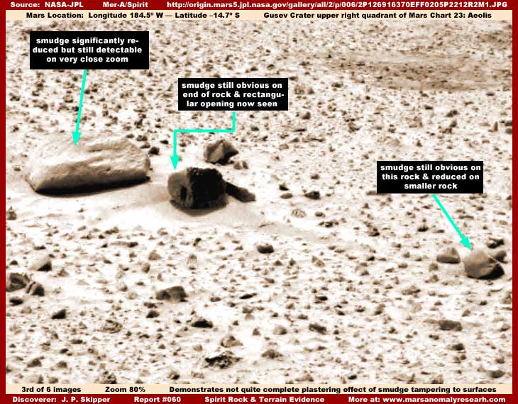
In the third image above from a different official image of the same scene, you now see that this scene is a little more normal looking. Even though there is just a little faint residual smudge tampering evidence on top of the largest rock to the left, it is hard to see and the rock's broad surface is now is beginning to look much more normal. Same with the broad surface surrounding terrain and its detail.
However, although much reduced, the fuzzy smudge tampering can still be clearly seen on the left end of the second largest dark color "rock" but more concentrated. Now the shape of this object is also more concentrated and now without the angular outlines constituting it and apparent in the second image above. You can also see that there is still a suspicious looking dark rectangle shape on the left end of the "rock" that was also seen heavily blurred in the second image.
In this image, it appears likely to be hole or opening and this does turn out to be the case in subsequent imaging below. However, in other more blurred imaging of this object evidencing more tampering, this appeared to possibly be a patch of tampering application. Also note the general shape of this object in this image with its elevated continuous spine across the top and sloped sides. This to will change in more and different imaging below.
Also, once again note the two larger rocks off to the right edge of the image. These were completely covered over and obscured by smudge image tampering applications in the second image but, here in the third image, you are seeing more of a rock shape emerging even though the top left portion of the lower of the two rocks still has a obvious area of smudge tampering left projecting up from it. Likewise, the general terrain with the field of smaller rocks looks much more normal now because the tampering applications there were the smallest in size and the concentration transformation effect has been very effective over broader areas like this.
Even though the second and third images are different official raw images, what you are looking at is not increased camera resolution resolving previous camera resolution defect or scan processing problems as one might assume. Rather you are witnessing a newly revealed (at least to me) digital image tampering technique whereby the digital smudge tampering is being run through filters that increasingly reduces, condenses, and concentrates the mapped and recorded tampering application sites. The net effect of this process is to increasingly snug and plaster these digital applications to the digital surfaces they are applied over causing the originally fuzzy featureless applications to appear solid and welded to the objects they are applied over. Also the process adds increased but false texture and detail to the objects and terrain they are applied to as well.
I suspect that this has occurred in the distant satellite imaging to but I never recognized it because there are usually no repeat shots of the same site that might demonstrate stages of imaging processing development as we see here. In this rover imaging, it is the repeat shots of specific physical areas that reveal the developmental stages. I suspect this is also enabled by a camera system that by their own admission measures in the incredible millions of pixels. It is hard to imagine imaging detail on such a fine level. The implications are very clear, we discover that the capability is present in this digital imaging to not only cover and thereby hide objects but to actually change their shapes and surface textures effectively.
If such imaging detail measured in the millions of pixels were not compromised by outside influence, one should be able to blow up these images nearly endlessly to look at objects down to their smallest detail and that would be true even in a normally compressed JPG image, although not necessarily true in a severely compressed one. That is one of the features of JPG/ JPEG imaging, unlike most other imaging formats, it can be compressed down in many different degrees or levels with an accompanying loss in detail and that includes down to a such a low level that the image integrity detail wise is severely compromised.
With that information in hand, you should be aware that most of the official raw data images in the released JPG compressed format of choice are so poor resolution wise that you can hardly blow them up at all without seeing "enlarged" pixels quickly blurring out any detail. This effectively gives them control of what one will be able to see and not see in such imaging.
This Spirit data appears to have been compromised by compression to such a low level in order to produce such poor quality imaging with very large pixels. That means you can't really effectively zoom in on any object for a closer look. Of course I'm sure that they would counter by simply informing us that they just reduced the image down to its smallest file size to conserve space for casual presentation in the media and over the Internet. You see, there are some larger files sizes available for download over the Internet. They are "processed" TIFF files and not true raw science data though.
As an example, a full resolution JPG version of an image might be say 1.0 Mb (megabytes) while the TIFF version might be 40+ Mb. That's typical and over 40 times the size of the JPG file. Can you imagine how many hours it would take to download such a file size via a dial-up Internet connection? It would even take a good while on a fast broadband corporate T-1 line. Even then what you are getting is not the even much larger raw science data image but a "processed" and compressed presentation TIFF image.
However, such an official explanation, if it were ever given(?), would be just so much misleading tripe. Why? Because the same poor quality JPG imaging is also currently and misleadingly presented and passed off as raw science data at the official sites. The message is clear. We really don't want anyone being able to access any of this millions of pixels resolution raw unprocessed science data and we're going to obfuscate any clear path to it.
Least any should still think that camera resolution is playing a role in the fuzzy quality of the rocks and terrain evidence presented here, such as in the second image, be reminded that the degree of tampering differs from object to object within the same image. Further, it is this very same millions of pixels resolution Spirit panoramic camera that is taking these pictures. Further, the target rocks and terrain examined here are only a few feet away from the edge of the lander.
In other words, this imaging of these objects from such a super camera system so close to target objects should be super sharp. Where it is not and also different from one spot to another within the same image rather than a universal problem throughout the image is explained by outside manipulation of the image's content. This is also confirmed by the very poor resolution released for public consumption being passed off as the raw science imaging that most often allows almost no closer examination and only large pixels.
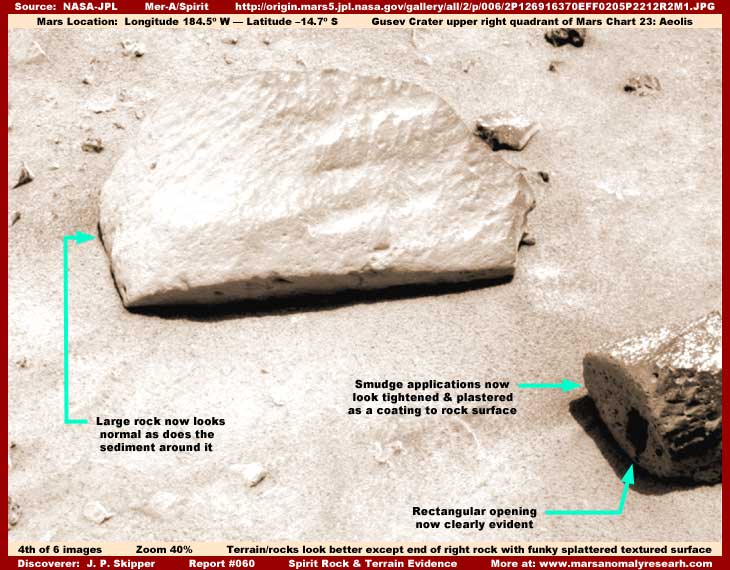
In the above fourth image from yet another science data strip of the same group of larger rocks, the largest rock now appears quite normal as does the general terrain now that it sits in. This is true partially because of the strong light reflectivity from its broad upper surface obscuring fine detail and partially because this strip represents the most advanced stage of the image tampering where it is now thoroughly concentrated and plastered to the broad surfaces it has been applied on. This also worked very well in the terrain provided some tiny but false detail there.
However, the outcome didn't quite turn out as well on the left end of the second largest rock at the right edge of the image. It is now thoroughly concentrated, tightened and plastered to the now cleaved end look of the "rock" but it takes on a rough splattered funky surface appearance as though some thick viscous material was splattered onto the end of this "rock." This leads me to suspect that the reason is because the original layers of tampering application were applied thicker to hide something more specific here. Could that be something associated with the rectangular hole or opening in the "rock" now so clearly seen?
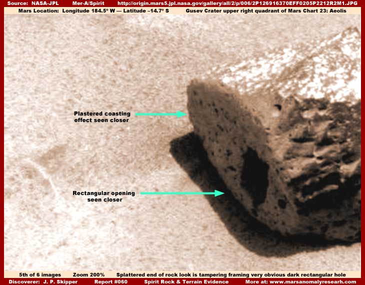
The above fifth image clearly demonstrates this splattered material appearance on the cleaved flat end look of this "rock." Note how different it is from the rest of the object where the condensed tampering was applied to it over the left end and upper surface. Note how this now dense uniform splattered plastered look also frames and accentuates the dark rectangular hole/opening break in this tampering field making it stand out sharper and more obvious.
So why is the rectangular hole left out of the tampering application? Why not cover it up as well? In my opinion, the automated tampering software probably left this rectangular hole visible mapping around its edges because there was simply no surface information to map to and work with within the hole. It is just basically a dark void and not a recognized anomalous surface from the software's interpretive programming point of view. The software maps to surfaces and they have to be present for it to do its thing over them. We are no doubt talking about artificial intelligence software here. It's very good but no better than its programming and certainly no substitute (as yet) for human judgment of new information variables like voids or empty areas.
Now I know that many of you will find the rectangular opening as the most important piece of anomalous evidence being presented and examined here. It may well be, but not necessarily so. There is just too much to speculate about and a perfectly rectangular hole, while not likely to occur naturally in nature, is still remotely possible. Note that the hole's edges appear a little ragged but that is a function of the fake material look framing the hole and the raggedness of the tampering application along the hole's edges. It is possible that this hole's edges are originally sharp and well defined but that really can't be determined here because of the effectiveness of the tampering application covering any such evidence.
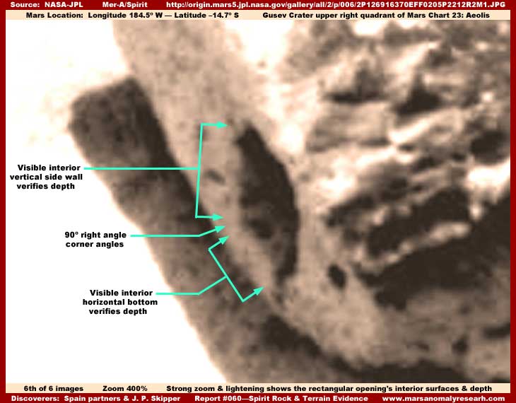
In the above last sixth severely lightened image, I can at least confirm for you that this dark rectangular shape is a rectangular hole and not just some dark rectangular patch of "something" as it appeared in some other darker and more obscured official imaging not shown here. Here in this image, there is clear evidence of a shadowed surface within the hole depths on the horizontal bottom floor and the far vertical side. So this is very definitely and clearly a rectangular hole.
What does that mean? I don't know. The tampering application covering the whole end of this rock and over the top surface prevents identification of anything that might have been associated with this hole giving a chance of increased information and enlightenment. Further, we can't see enough inside the hole to reveal anything additional. Such a perfectly rectangular hole in such a otherwise intact hard rock is obviously suggestive of artificial manipulation of this object as compared with natural rock but ultimately trying to speculate beyond that is just trying to extrapolate too far beyond the available evidence.
On the other hand, take a look again at the second image presented above in this report and note this particular object's outline there. Even though heavily blurred by what I suspect is the beginning stages of tampering treatments, this object's outline appearance takes on a entirely different multiple angular look. This may not be the rock it now so appears to be but an object of right angles much more highly suggestive of artificiality before filters changed the general shape and texture of this object in the concentrating transformation tampering effect.
This is a good example of what I have reported many times. There can be no understanding of what is really on Mars without first recognition of the many forms of image tampering and their impact on visual evidence.
CONCLUSION
One last thing I'd like to add is my opinion as to at least one set of reasons why these rocks and terrain have been so tampered with and with such universal applications. Why go to such trouble mapping tampering in the sediment areas and on so many of the rocks? The most obvious question is can this be hiding something specific and, if so, what could that be?
I suspect that the answer lies in taking advantage of these camera system's super resolution capacity and preventing that capability from being too revealing. This finest resolution imaging not shared with us allows the mapping of the terrain in super fine imaging down at individual pixel level and then subsequently mapping tampering applications of various kinds into the mapped terrain. It may on occasion have something to do with hiding specific life evidence such as possibly hiding what ever is associated with the dark rectangular opening or even tiny organism and/or small vegetation life in the terrain. But, I think it goes beyond such considerations into a more universal all purpose goal.
Here's what I think.
First the true terrain and all its soil, rock, and any anomaly detail is mapped down to super fine pixel level detail by automated software working on super computers and probably on AI (artificial intelligence) super computers. Any anomalous real information is noted and recorded (mapped) and earmarked for future more specific tampering applications. Then general image tampering blur and smudge applications and now with color added is mapped into the terrain and on the rocks as well as over any specific anomalous information. This allows differing but artificial color applications in the same scene and is how the more realistic looking color and stereo effect is generated and how you get reddish soil and blue rock hues in the same image.
This can actually be identified and confirmed by very close and careful examination of the terrain detail in the color images. Further, I have done so although there is no image room to show this research here. This mapping over real evidence insures any inconvenient tiny organism life or vegetation anomaly detail will not be seen in even a version of the mega raw image files, if they ever had to be produced, must less the smaller but still huge "processed" TIFF files and reasonable differing color capability mapped to specific objects is an added bonus.
For example, the recent flap over the too strongly artificially colored Spirit imaging was a result of the entire image, including the sky, then being overall tinted with too strong a reddish hue. This was a misdirection change tactic and was done on purpose with anticipation that it would be regarded as too much and going too far. If someone "out there" doesn't generate a flap over this, they would have seen to it themselves to draw out the issue and any detractors. Those that are drawn out and jump on this complaining and saying we gotcha will then mistakenly settle back on the original mapped colored versions as the truer "legitimate" view. This misdirection tactic insures that the also fake settled on color version with the more realistic mapped color is generally accepted. Tactical and tricky isn't it.
The process of migrating better more complete acceptance to the also fake fall back on artificial mapped colored version is essential effective misdirection away from the realization that this imaging also isn't real and, worse, has been tampered with and compromised in other much more important ways than simple color manipulation. Conveniently, when the media hangs on your every word and declines to present any information to the contrary or verify evidence for themselves, such as the type of information you are examining here, the spin job is effectively spread and gets done. They have long experience at this.
It is sort of like the current flap over the now admission of lack of WMD (Weapons of Mass Destruction) evidence in Iraq that was used by the leadership as justification for the war that got rid of some very bad people and also conveniently secured control of a strong Mideast power base in the form of those all important oil fields. Now, in the aftermath, leadership with the most independent (even rebel) recognition, at least appearance wise, sets out to seek the truth by dutifully heading up an investigation into who is responsible for all this incorrect information. However, note that the real formal focus of this effort is conveniently not on the powerful top but on the down slope intelligence community.
This effectively gets in front of and deflects and misdirects any public based investigative initiative effort away from top political leadership. Many politicians for many reasons can't stand close scrutiny and some would throw their grandma to the wolves to cover their butts. So such a investigative effort at the top might very well start the falling of the dominos effect and eventually the arrival at truth for both the leadership and intelligence community. But, oh no, we can't have that now can we! So what we're going to focus on is the shadowy world of intelligence where any effort is soon absorbed and dissipated into the murk of this world and hardened intelligence soldiers so use to subterfuge and patriotic sacrifice aren't likely to be giving up anyone of real importance.
Even if a few sacrificial down slope intelligence heads must roll for show to satisfy the public, it is the same as blunting and dooming this effort before it can even get started with respect to arriving at any real encompassing truth and responsibility. It is how spin and misdirection is done and the public is thoroughly conditioned to it and has long ago become accepting of it through prolonged exposure. It's the same with the scientific community who has likewise been conditioned into accepting too much assumptive paradigm blindness by the kind of "stuff" you see here this report.
It is how spin and conditioning is done in what is suppose to be scientific endeavors but is really only a cover for subterranean covert intelligence operations directed at ends unknown to us and in which we do not participate or have any say. The pathetic quality of this situation is a responsibility shared by us all, not just a few in secret. It is what happens when we don't want to be bothered by complex issues and abdicate responsibility for such issues to others. We in the public cannot then rightfully act surprised when they pick up the ball we dropped and run with it to unknown hidden ends.
CREDIT
I would like to thank interesting friends in Spain Juan Carlos/Sisifo and Georges Diaz Montexano and the forum they discuss in for their contribution to some of the information in this report. When first asked my opinion of this hole, which I had already briefly investigated weeks before, I told them that I thought it was image tampering application because that is what it appeared to be in some of the official imaging that I had been exposed to up to that point.
But they insisted that it was a hole and provided imaging demonstrating that. This caused me to go back over all the official imaging of this object. The net result was me confirming that this was indeed a hole just as they indicated, especially Georges and he is right. More importantly, their determination on the hole issue focused my attention on all the repeat imaging associated with this object and the discovery of the newly revealed tampering technique. Good work guys.
DOCUMENTATION
http://origin.mars5.jpl.nasa.gov/gallery/all/2/p/006/2P126916370EFF0205P2212R2M1.HTML: This link accesses the official science data source image for my first image in this report. There are others but this one is an enlarged image so that you can see some detail and both of the two rocks mentioned. Be sure to open the "View Full Image" link at the bottom of the page.
http://origin.mars5.jpl.nasa.gov/gallery/all/2/p/001/2P126471535EDN0000P2303L6M1.HTML: This link accesses the official science data source image for my second image in this report of the fuzzy very obvious tampering on rocks, objects, and terrain. Be sure to open the "View Full Image" link at the bottom of the page.
http://origin.mars5.jpl.nasa.gov/gallery/all/2/p/005/2P126814542EFF0200P2213L2M1.HTML: This link accesses the official science data source image for my third image in this report demonstrating the tightening and concentrating developmental transition of the digital image tampering applications on the digital surfaces they are applied to. Be sure to open the "View Full Image" link at the bottom of the page.
http://origin.mars5.jpl.nasa.gov/gallery/all/2/p/014/2P127604438EFF0309P2543L3M1.HTML: This link accesses the official science data source image for my fourth and fifth images in this report demonstrating the now normal appearing rocks and the close-up view of the object now appearing as a rock with the rectangular opening in it. Be sure to open the "View Full Image" link at the bottom of the page.
http://origin.mars5.jpl.nasa.gov/gallery/all/2/p/014/2P127604364EFF0309P2543R6M1.HTML: This link accesses the official science data source image for my sixth image in this report demonstrating the visual depth of the opening or hole. Be sure to open the "View Full Image" link at the bottom of the page.
, Investigator
![]()