
MARS SOUTH POLAR BIOLOGICAL
LIFE: PART 2
Report #085
March 27, 2005
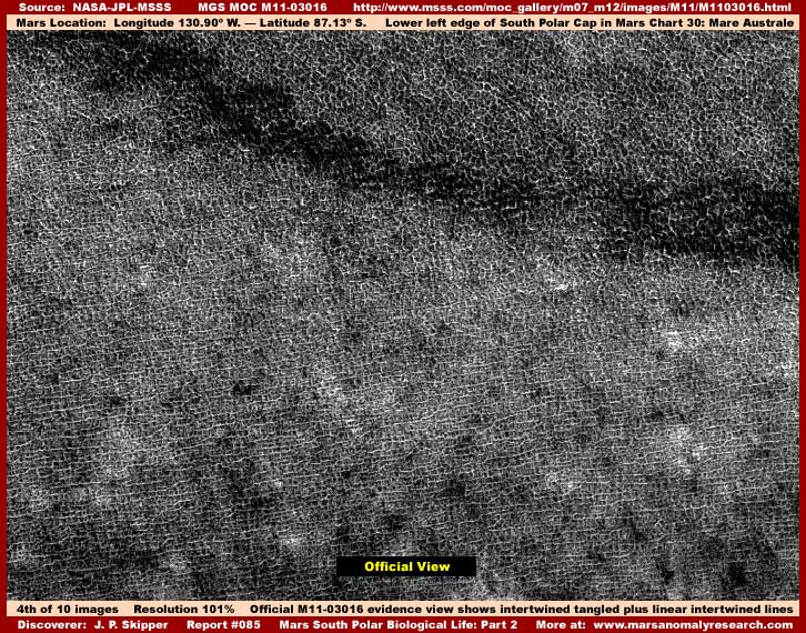
As you can see, the above fourth image in this report demonstrates yet more of this same official level created inverted and altered science data illusion passed off as real evidence. I've elected to show this evidence to you from strip M11-03016 because it is slightly different than that from the Part 1 strip M09-00068 previously shown. The first difference that is apparent are the great many linear lines in the lower 2/3 of the image below the dark band. Less immediately apparent is the fact that the field of tangled lines above the broad dark band area in the upper part of the image is the same as the evidence from M09-00068 in the first image in Part 1 of this report and without any of the linear lines.
If you will go to the official science data M11-03016 image and examine it there, you will see that the dark broad band extends in a slightly wavy line over most of the length of the strip. Closer examination there will reveal that all the tangled line illusion evidence to one side of that dark demarcation band does not have any of the linear line evidence in it while everything to the other side of the dark demarcation line does have it. I'm not sure what significance this has or the why of it but it is evidence with a difference and so I am compelled to report it.
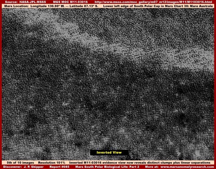
Regardless of the official level illusion altering the visuals of the evidence in the fourth official image view, the above fifth image I've inverted of the exact same M11-03016 scene as the fourth image demonstrates the reality of this particular Mars terrain on this peninsula and at the same time corroborates why the image file size count is so large. Once again we are looking at many thousands of distantly seen well defined hard objects demonstrating a great deal of density as well as uniformity.
In my opinion, in this rather poorer resolution imaging, we are at the very minimum looking down distantly at the tops of densely packed hard object life evidence of some kind here as opposed to any kind of natural geology. Further, I suspect that each object down there represents a earlier stage of development biological life form in the form of individual colony and/or fungi forms adapted to flooding and receding water conditions on this peninsula. I suspect they flourish most when submerged for months under water and some can out grow others to gigantic size within a seasonal water cycle if the conditions are right. Last, I suspect that we are also looking at a form of civilization agriculture and food resource here.
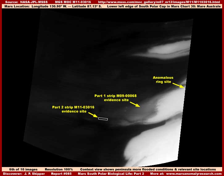
The above sixth image is the M11-03017 companion context wide-angle image accompanying the M11-03016 narrow-angle strip the evidence in this Part 2 is sourced from. As you can see, this image shows higher flooding water conditions on the peninsula and this M11-03016 evidence site is located well out on the end of the peninsula deeper in the darker area flood conditions.
The detail in the above fourth and fifth M11-03016 images is a little poor relative to some other imaging in this report. This may be due to the evidence being seen through a refraction layer of water surface extending just above the tops of the submerged biological life. The water surface isn't visible in this straight down satellite imaging and that is typical of fresh clear still surface water as seen from above at great distance.
The location of this site as seen in the above sixth context wide-angle image further out on the end of the peninsula in the darker area that is assumed to be water tends to reinforce this conjecture. Further, the January date (1/21/2000) of this image would coincide with the seasonal time of the year of more serious beginning stages of the flood cycle and increasing water levels at this site. You should be aware that at the peak of the flood cycle is a month or two later and the flood cycle shoreline level reaches all the way up to and peaks at the Anomalous Ring site partially submerging it at that time.
In any case, with this Part 2 additional similar corroborating evidence demonstrating more of this kind of tampering, biological life and water evidence on this peninsula digested, lets move on to Part 3 and its evidence:
DOCUMENTATION: (for Part 2)
http://www.msss.com/moc_gallery/m07_m12/images/M11/M1103016.html: This link takes you to the official science data M11-03016 narrow-angle and M11-03017 context wide-angle strips that supplied the main biological life evidence here in Part 2 of Report #085. I used the third listed slower loading but higher detail .GIF image just up from the bottom and rotated 90º clockwise horizontal to maximize the amount of terrain surface area I could get in the image.
![]()