
WHEN MARS MESAS AREN'T
Report #107
September 10, 2006
In my opinion, the secrecy agenda sometimes just goes a little too far in over and over again trying to make sure that they herd the perception psychology of the Mars satellite imaging science data in the safe directions that they want. For example, according to my interpretation of the evidence as I've so far shown, the Mars South Polar Cap is covered with a great multitude of water ice and terrain forms as well as melt water depression systems of all different shapes and sizes. Of course any interpretation that moves toward the concept of just surface water presence alone on Mars in a liquid state is a big no no.
The secrecy agenda's dilemma is that far too many of the melt water depression systems, even after their surfaces have been covered over with image tampering, still look too much like what they are even with their visible surfaces hidden. Why? Well logically because a mistake in the tampering software causes it to still map to and reproduce the larger overall terrain forms and features. This both reveals and preserves their basic shapes right down to and including solar dark shadow and light reflectivity. The result is that surface water sites still look like well defined depressions with a flat smooth barren and empty field of "something" self leveling in them suggestive of either currently being a fluid or a fluid in a frozen state.
So, the compensating and preemptive tactic appears to be to substitute psychology in the form of words trying both to influence other's perception and interpretation of such visual evidence and at the same time to fire a warning shot across the bow of any would be uncooperative types that might dare to wonder and out loud if these might actually be water sites. This preemptive tactic warns others that this evidence has been officially identified and to leave it at that.
Of course such tactics means not very much to this researcher. Frankly, although I have no wish to attack other interpretations and try to avoid that if I can, I've just gotten sick of seeing this tactic of trying to substitute words and psychology for real evidence used over and over again, so here goes my little contribution to this issue. First will come six officially promoted images of relatively ambiguous evidence supporting the much promoted elevated mesa geology scenario and then will come just three but very telling images that will better define the truth.
FIRST THE OFFICIALLY SELECTED EVIDENCE
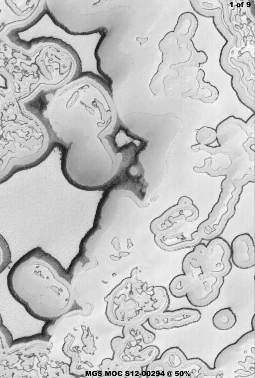
MGS MOC Release No. MOC2-1433 — April
15, 2006
Image #: S12-00294 — Latitude 85.5º S. - Longitude
76.8º W.
htt://www.msss.com/mars_images/moc/2006/04/15
The above first image is from the MGS MOC strip S12-00294 not yet released in the main raw image database but pre-released as a picture of the day by Malin Space Science Systems (MSSS) with caption explanation. These releases provide a interpretation of select evidence before the material eventually trickles down into becoming a part of the main raw image database without such commentary commitment. For practical purposes such commentary by subcontractor Malin Space Science Systems can be regarded as an official interpretation of the selected evidence since JPL or NASA usually in turn just parrot these conclusions.
In the above first image, take note of the darker rimmed but otherwise flat level areas on the left side. Despite these looking like depressions with a flat self leveling substance in the bottom, the visual evidence has been altered enough by the image tampering creating just enough visual ambiguity to enable the official description that these are mesas and therefore just geology. That is, if you at the same time suspend your own intellect and follow someone else without questioning much of anything.
Now my dictionary says a mesa is defined as a elevated land formation having a flat top and steep rock walls: common in arid and semiarid locales. Did you get the "arid" and "semiarid" association? From the secrecy agenda point of view, that is an important psychological association.
Now the official explanation in the caption that goes with this above first image states "The large relatively flat-lying, puzzle-like pieces in this scene are mesas composed largely of solid carbon dioxide." So right away the peripheral associations are "arid" and of course CO2 has no liquid state, especially in open environs where expansion is possible. So right away we are being psychologically moved away from the concept that these well defined irregular spaces with such empty looking flat level areas within them might be surface liquid sites. To move this even further away, we are told that these are mesas, which of course are elevated flat top terrain forms that explain away what might have been a very suspicious flat level area. This also serves as a warning shot across the bow. That shot says we've declared what these are and that's the end of it.
Now I've included this above first image because it demonstrates one of the many visual variety looks of this type of "mesa" evidence on the Mars South Polar Cap. Another reason is because the sun angle is not quickly apparent in this carefully selected image and so the look of these sites are going to be as ambiguous and as close to and favorable for the "mesa" explanation look as it is going to get in the rest of the evidence presented here. After all, it isn't easy making one thing appear to be another.
What do you think? Does it do it for you? Do these sites look like depressions or elevated mesa forms to you? Now that I've brought the question up, not quite sure? Well that's a typical reaction, they are well aware of it, and that's why they keep repeating and pounding home their preferred concept so much so that the initiative is not lost in influencing interpretation.
Note that all of the many images in this report will be in black and white to match what is seen in the original strips. All I've done is brought the scenes into sharper focus. I don't want to be unfair to the official position and I suspect that for example the use of a little color would have brought these scenes into somewhat better perspective that might have resulted in more interpretations unfavorable to the official position. However, for many of you I think we can get there without it before this report is over.
Also, pay special attention to the size percentage labeled in each image. For example, the above first image is presented at only 50% of its very large official size. I did this to provide as much wider area context information of the terrain surrounding the "mesa" sites as possible. For a bigger and closer look at the forms and to see even more surrounding context information in the whole strip, surf to the official image at the link immediately under each image.
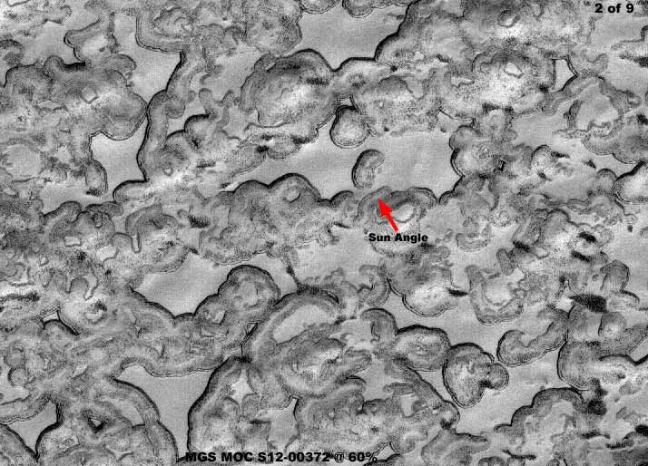
MGS MOC Release No. MOC2-1447 — April
29, 2006
Image #: S12-00372 — Latitude 86.8º S. - Longitude 341.3º W.
http://www.msss.com/mars_images/moc/2006/04/29
The above second image is from the S12-00372 strip pre-released with caption at the above link. Here, by my interpretation, there are a lot of elevated rounded mottled terrain forms interspaced by well defined depressions with uniformly flat level looking surfaces in them very suggestive of self leveling liquid. Despite the very poor resolution in this image, the sun angle can still be determined and this adequately defines these as depressions but only depending on which sun angle you accept and use. That is the ambiguity element of these officially carefully selected images.
The official caption at the above link states that this is "...an undulating scene in the south polar region of Mars. Small, elevated mesas of smooth, relatively homogeneous-appearing material are separated by low-lying regions that are speckled and darkened in some local areas. Over the martian summer months, sublimation of solid carbon dioxide—the bright material in the scene—contributes to the darkening of the sides of the mesas as well as the low-lying regions between them." In other words, the tops of the mesas are flat, bright and smooth appearing because they are still covered with a blanket of reflective CO2 snow/ice that has not yet eroded away as nearby surfaces have through sublimation.
Is that what they look like to you, elevated mesas? How about the darker rounded or circular areas? Do they look like depressions between the "mesas" to you? Hard to be definitive in such carefully selected images isn't it. Still not sure? Well move on to the next officially selected image below.
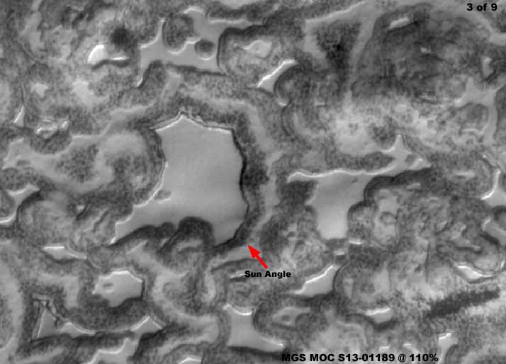
MGS MOC Release No. MOC2-1458 — May
10, 2006
Image #: S13-01189 — Latitude 86.7º S. - Longitude 343.3º W.
http://www.msss.com/mars_images/moc/2006/05/10
The above third image is from the S13-01189 strip pre-released with caption at the above link. This image provides a much closer 110% view and the true nature of the larger depression (uh excuse me, mesa) pointed out by the red arrow is now a bit easier to identify. Again the official caption states "In this image, mesas composed largely of solid carbon dioxide are separated from one another by irregularly-shaped depressions." In other words, the darker mottled areas are the depressions and the flat more bright reflective areas are the mesa tops.
Is this what you see? It certainly isn't what I see, especially in this closer image. I see depressions as defined by the sun angle with light reflective shores on one side and shadowed shores on the opposite side, both consistent with sun angle as represented by the red arrow. I see depressions full of a relatively shallow self leveling flat liquid surface even though that surface has actually been covered over by image tampering applications that map and conform to it hiding the true surface from view. I see the darker surrounding context terrain as undulating low-lying but elevated above the depressions surfaces who's true nature is also hidden by image tampering applications and even that is very poorly seen due to serious resolution problems that shouldn't be the case in this satellite imaging.
Please note that the flat level light reflective surfaces are devoid of detail except for occasional small islands so typical of shallow surface water sites on tundra and note how plentiful the sites are. But of course we aren't suppose to see that, we're suppose to see only flat top elevated mesas down there because that's what we've been told to see and that is of course what we will see. After all, admittedly a CO2 snow/ice covered flat mesa top might well look a little like this to. Even so, I find it just so incredible that so many well educated science and academia types with a long list of degrees after their names can follow someone else's lead so blindly and unquestioningly just because of who is trying to do the leading. It's like children following the Piper just because he's the Piper.
Please don't do that here in following my own lead. Think for yourself. Weigh the visual evidence you see here for yourself and come to your own conclusions. Do you see flat top mesas here with steep sloping sides or do you see many depressions that appear to full of some flat surfaced self leveling liquid substance? Remember that visual appearances can often be deceiving but, while you're at it, also remember clearly that this also applies to the official interpretation as well as my work and conclusions. They ask you to believe on trust based on the source and I ask you to think and question based on the visual evidence. That is the difference between us.
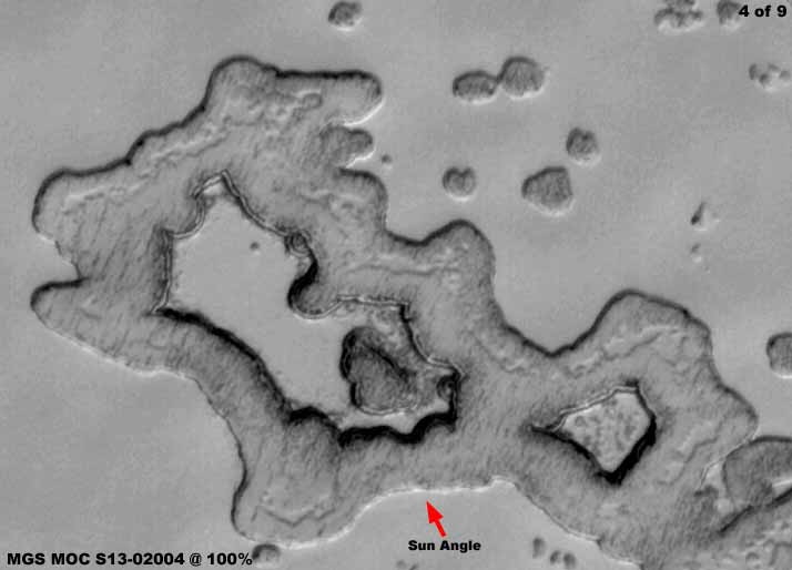
MGS MOC Release No. MOC2-1493 — June
14, 2006
Image #: S13-02004 — Latitude 85.6º S. - Longitude 349.8º W.
http:www.msss.com/mars_images/moc/2006/06/14
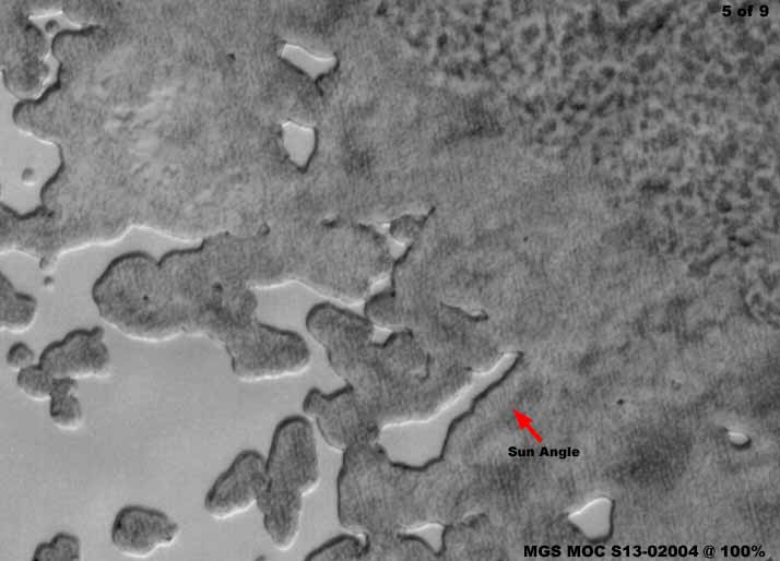
The above fourth image is from the S13-02004 strip pre-released with caption at the above link. Again the official caption at the above link states that "During the summer, the scarps that delineate the sides of the mesas..." If we logically extrapolate this meaning as being the same as from the previous official statements, we are again suppose to assume that the flat level surfaces are the tops of mesas. What does this scene look like to you?
The reason that I've included this closer full resolution image is to demonstrate that the flat level surfaces extend out unbroken far into the surrounding terrain. This tends to work against an interpretation that they are geological mesa tops. If you will go to the above link and take a look at the full official image, you will see that the flat level surfaces extend far out into and encompass a huge wide terrain area of which my imaged spot is only a small portion of.
Do you think that the flat level smooth areas represent a level blanket of CO2 snow/ice and that the darker area in my above image is just a low depression area in the CO2 blanket field that has been eroded away by sublimation leaving underlying darker rougher layers exposed? If so, be sure to mentally reverse the red arrow representing solar sunlight direction and it will work well for you. However, also ask yourself why sublimation erosion would happen only in such well defined spots leaving the bulk of the surrounding CO2 blanket areas so intact? Remember that sublimation is a process brought on by general warming trends that should theoretically impact the entire area the same rather than just in such isolated defined spots.
On the other hand, could it be that the red arrow direction in the above image is true and that the darker area is actually low-lying but elevated terrain forms with the sun angle casting short shadow into a enclosed depression and onto a shallow flat self leveling liquid or frozen liquid surface? Could it be that the indistinct quality of the darker area is product of image tampering applications mapping to this terrain form and obscuring something there? It's your choice but, at the very least, question what you see!
MGS MOC Release No. MOC2-1493 — June
14, 2006
Image #: S13-02004 — Latitude 85.6º S. - Longitude 349.8º W.
http://www.msss.com/mars_images/moc/2006/06/14
The above fifth image is another from the same S13-02004 strip pre-released with caption at the above link. I've included this scene because the view moves further to the right of the fourth image and onto what I consider to be a shore of mostly darker material progressively less broken up by shallow water tundra systems the further to the right and inland one moves the view. Note the fuzzy very indistinct quality of the darker areas and how there is a vaguely seen boundary separating two different visual terrain types.
You need to understand where I'm coming from in my questioning of this data. I believe that logically the MGS MOC satellite camera systems going to Mars in the late 1990s would at minimum be every bit as good as the best or nearly the best satellite imaging technology available at that time here on Earth and that nothing less would have been sent on such a expensive space exploration undertaking to a distant world. In fact, I would go a step further and suspect that cutting edge technology not yet available to the consumer industry Earth satellite systems would have almost certainly been the choice to go to Mars and every bit close to being up to the standards of some of the military intelligence's best late 1990s imaging technology and that was very very good.
That means that technology wise the satellite imaging examples we see here of the Mars South Polar Cap area should be many times better than what we are looking at and at the very least up to the Earth consumer/industry standards. Further, on Mars the camera systems do not have to contend with the obscuring atmospheric conditions so typical of here on Earth and therefore should be much clearer because of that as well. Yet this is clearly not the case as well demonstrated by the complete lack of smaller detail in darker areas of the above fifth image, detail that would readily appear in just run of the mill Earth satellite image of that time.
In fact, speaking of what we have a right to expect of a run of the mill Earth satellite image, take a look at the fifth and last image at this link in my older Report 055 in 2003 titled "Towers in the Sun." It is a simple commercial Earth satellite image of the downtown area of a major Earth city. It was taken from a distance of over 400 miles up in space compared to the average MGS MOC image of Mars taken from only an average of 230 miles up. Also, the Earth image has to deal with the Earth's heavy atmospheric cover while the Mars satellite imaging does not have to deal with much of any atmospheric interference.
The level of detail in this very ordinary commercial Earth satellite image is dramatically greater than the poor obfuscated imaging provided by the scientific Mars satellite imaging as released to us. Further, the difference is even greater and more dramatic when compared to the incredibly sorry DOD/Navy military intelligence Clementine satellite imaging of the Moon with satellite camera orbits even closer to the Moon's surface than on Mars and imaging taking place through no atmosphere at all.
How can such a dramatic difference be explained? Are we to mark it off as just inexplicable and leave it at that? Are we to believe that lesser camera systems by a substantial margin in a completely scientific endeavor were sent to Mars on the MGS mission? If so, that would equate directly to incompetence all the way up to the highest scientific levels. Can you accept something as illogical as any of those considerations? Do you even think that the general science community would have accepted such a scenario on something so important? I know that I can't! Logically the only other way to arrive at this kind of incredibly very bad quality imaging we are looking at here as it has been released to us, where we can only see huge forms decently through this relatively clear Mars atmosphere, is by intentional manipulation of the images by someone to achieve this poor result. The logic is inescapable because nothing else sounds even remotely reasonable.
That's why I've included the above fifth image here to facilitate bringing this point home into awareness again and also to get you to think and question rather than just blindly accepting the official pabulum that is so liberally dished out to us. While the large terrain form shapes we see here are no doubt real in this MOC South Polar Cap imaging because the tampering applications are of the mapping kind, completely automated, and conform to those forms, the smaller ground level detail is not real and not even present in crude form. Rather, it is hidden under a mess of obfuscation tampering that generally renders the image of such poor visual quality and indistinct that only basic giant terrain forms come through with any basic truth.
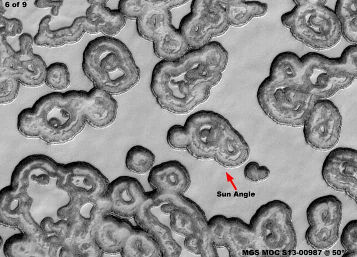
MGS MOC Release No. MOC2-1425 — April
7, 2006
Image #: S13-00987 — Latitude 86.9º S. - Longitude 340.2º W.
http://www.msss.com/mars_images/moc/2006/04/07
The above sixth image is from the S13-000987 strip pre-released with caption at the above link. The official caption for this image states "...image shows south polar mesas composed largely of carbon dioxide separated by generally circular depressions." In other words, it's the same story. The flat smooth areas are the tops of elevated intact CO2 blanketed mesas and the darker rounded mottled areas are sublimation eroded away depression areas exposing the lower underlying darker material.
To accept this explanation, all you have to do is reverse my red arrow for the solar sunlight direction and use a little imagination to fit the official position. Even though I don't accept it, it sounds sort of reasonable and that's the beauty of these carefully chosen images where their ambiguity fits either explanation, mine or theirs. After all, who am I as a lone voice to challenge the 800 lb. gorilla in the room and the entire scientific community so comfortably following and backing up that gorilla? As long as the water is muddied and the issue remains debatable, the secrecy agenda is pleased.
The above sixth image was included here, not because it is definitive in some way, but to repeatedly demonstrate how these images are carefully chosen for their ambiguity that enable the official explanations or at least can't detract from it very well. It has also been included to give you a look at a variety of the shapes this kind of evidence comes in.
Okay, so much for giving you exposure to this officially carefully selected visually ambiguous and certainly less than definitive type of evidence that is used to reinforce the official position that Mars is primarily a hard frozen arid world with a primarily CO2 atmosphere so thoroughly hostile to life as we know it. What say you and I now take a look at a little of the same kind of evidence but now selected and which tells a different less ambiguous more definitive story.
NOW THE SKIPPER SELECTED EVIDENCE
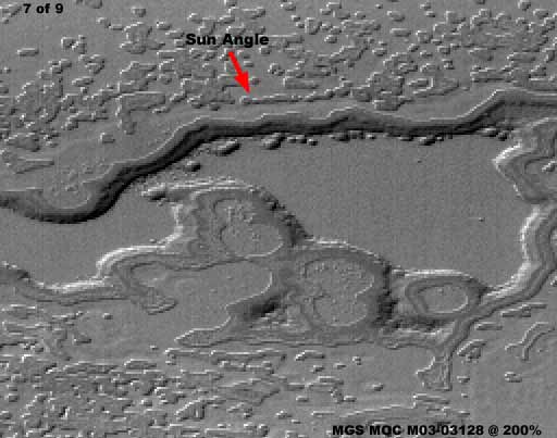
MGS MOC Image No. M03-03128
http://www.msss.com/moc_gallery/ab1_m04/images/M0303128.html
The above seventh image is from the M03-03128 science data strip in the main MGS MOC raw imaging database at the above link. This is a very long and narrow image strip and as usual heavily resolution compromised typical of so many strips of the Mars South Polar Cap and Region. The result is that blowing this image up just to 200% to get a decent look at what is in it is difficult and that's why the image you see above taken from one side of the strip to the other is smaller and a little more grainy looking.
Strangely enough, no one at official level chose a strip like this to support their CO2 blanket "mesa" erosion scenario. Can you beat that! Wonder why? Well, even though the imaging is visually very resolution compromised, it's because we can still see what needs to be seen here. Note the string of small round forms located along the back edge of the "mesa." Note the consistent sun angle brightness and shadow very clear on these smaller objects. Now note the sun angle bright reflectivity and darker shadow on the perimeter edges of the larger "mesa" form. Now also note the sun angle brightness and darker shadow effect on the great many smaller objects scattered all throughout the surrounding terrain.
Every last speck of this considerable evidence collectively 100% demonstrates conclusively that the true sun angle is the same as pointed out by my red arrow, so there is no ambiguity in this regard. Further, all of this evidence also demonstrates definitively and conclusively that this is a well defined depression and those small objects are small islands strung along the back shore. In other words, this is most definitely not an elevated mesa of any kind. Yet, this is the same general type of smooth surface image evidence that the official explanations have so carefully been selecting as they pound their theme of CO2 blanket and sublimation erosion indoctrination home over and over again, only here the ambiguity element is gone and some definitive conclusion can actually be reached pointing in a different direction than that officially promoted so hard.
Here there is truth you can see for yourself and you are not required to trust mine or someone else's take on things because you have some mainstream traditional faith in their integrity. No ambiguity or leap of faith required here, just plain in your face unequivocal evidence and only one conclusion fits all of the evidence. That conclusion is depression filled with a flat self leveling surface not even remotely to be confused with elevated mesa covered by a CO2 snow/ice blanket.
My point here is, if they can get the elevated mesa interpretation wrong on something so obvious, how much faith can you place in the accuracy of their CO2 blanket position? Either someone isn't the brightest candle around here or someone is feeding us a load of crap. I cannot accept that they are that dumb on something so obvious but can you?
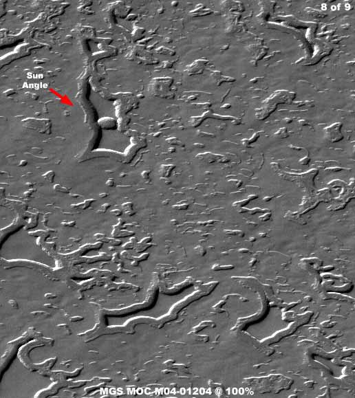
MGS MOC Image No. M04-01204
http://www.msss.com/moc_gallery/ab1_m04/images/M0401204.html
The above eighth image is from the M04-01204 science data strip in the main MGS MOC raw imaging database at the above link. The red arrow points toward the most definitive piece of evidence. Note that the round island form in the middle of the depression and its sunlight reflectivity and shadowing conclusively demonstrates that this is a depression with a flat smooth self leveling no doubt fluid substance in the bottom. This evidence should be so obvious that I don't think that I have to explain it again here.
Further, this also has clear implications for all of the other similar "mesa" sites in this terrain not lucky enough to have the definitive island evidence in them. If you can shift gears and ignore the island site evidence and think that the other sites in this view are elevated mesa forms, then neither logic, this evidence, or I can help you.
An additional truth is that all of this scene and so many others like it is blanketed over by image tampering coating that covers everything including elevated forms and the interior of the depressions. That is why the color texture looks so uniformly dull and the same broken up only by a little sunlight bright reflectivity and shadowing which light and dark tones have been recreated by the mapping type tampering.
This is what makes this planetary satellite imaging so incredibly crummy. It is how both offending and otherwise normal detail is successfully obliterated while basic larger forms are preserved and/or recreated to provide enough detail in the scene to hopefully disguise that this happened. It is how the water surfaces are covered over and hidden, even if a bit imperfectly. The competent but slightly imperfect software maps to and conforms its applications to the basic terrain forms and flat surfaces but still revealing that they are present underneath this coating.
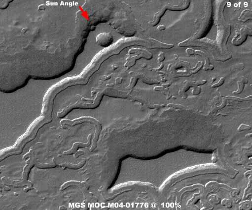
MGS MOC Image No. M04-01776
http:www.msss.com/moc_gallery/ab1_m04/images/M0401776.html
The above ninth image is from the M04-01776 science data strip in the main MGS MOC raw imaging database at the above link. Once again the red arrow points to the main evidence which is the round island in the larger depression system. The sunlight bright reflective side and the opposite shadow side of the island is perfectly consistent with the depression raised shores to definitively and conclusively demonstrate that this is a depression and most definitely not a elevated terrain form like a mesa. Once again there is no ambiguity here and no interpretation differences possible enabled by such ambiguity.
Now move your eye down to the next well defined smooth area in the bottom foreground of this same image. Note that this other evidence site does not have any such island in it to eliminate visual ambiguity and it could be interpreted in different ways like the first six officially carefully selected images in this report, that is if the other unambiguous site was not present. After all, it is the same type of evidence that has been so carefully selected for its ambiguity for official purposes but here the neighboring context evidence with the round island in the same strip tells the real truth. You can bet that this scene or strip would never be chosen to further the officially promoted blanketing CO2 and mesa scenario.
Let's face it, their choice in trying to manipulate us all via this kind of evidence was a serious error in judgment. It's all right if one takes only the path of least effort and looks only at the carefully selected ambiguous evidence that they provide for us to easily look at. But, if one goes beyond this easily provided evidence and goes to the effort of looking for more for oneself, there are great many images that readily reveal the real truth. This was not a limb that they should have stepped out on and gambled with. It demonstrates that they are spoiled and arrogant and lacking in respect for the public, science, and academia communities because they have gotten away with such manipulation so well in the past.
This particular type of surface water site versus mesa site evidence exists in the many hundreds if not many thousands in the Mars South Polar Cap area. The ambiguous variety so loved by the official position as represented by the first through sixth images in this report are just a sample of the total available that can be interpreted different ways. May I suggest that you out there doing this now stop putting out this misdirection so repetitiously, as it is easily answered with the many examples of more of the definitive quality evidence as I've presented in my seventh through ninth images in this report.
The automated tampering software is good and I have no doubt that its programmers are brilliant and I can respect that but nothing is perfect and especially when the attempt is to spread its purposes over millions and billions of different terrain level details in hundreds of thousands of image strips. The sheer numbers guarantee obfuscation problems and it is effectively impossible to anticipate all of the potential boondoggles. As time goes by they learn as they go and make adjustments to the programming as need to meet new unanticipated problems.
That is why is would not be wise to expect too much out of the forthcoming MRO imaging no matter its much touted advanced resolution capabilities. Well over a decade of development separates these MGS MOC science examples from the current MRO science and, as camera and imaging technology advances over time, so does the technology and ability to obfuscate it also advance. Remember that the current ongoing rover imaging advanced resolution was also promoted a great deal in advance and look what has been released to us on that.
What you've seen here in this report is just one way in how the late 1990s MGS MOC imaging faired with respect to surface water site obfuscation in the Polar regions. As you can see, when the technology doesn't quite get the job done adequately, the heavy weight types just step in with some supplemental misdirection psychology based on words. It is both ridiculous and brilliant, depending on the point of view. Believe it or not, I'm not particularly offended by this because it takes some smart people to skillfully develop this kind of stuff and implement it consistently over decades taking advantage of their powerful positions in government industry, business, and the media and I have to respect that even if I disagree with it.
What I'm more offended by is this constant promotion of ignorance for the great multitude in general foolishly and short sightedly promoting a widening permanent schism between the few and the many. This can come to no good end and that should be very obvious to anyone with half a brain. There has to be a mending and healing of this foolish schism and that can only be done with some liberal doses of corrective medicinal truth.
, Investigator
![]()