
MARS STRANGE MOUNT & PIT EVIDENCE
Report #120
May 26, 2007
This report is both about bio-life and geological evidence. Some of the bio-life evidence in this report is dramatic looking but represents somewhat of a departure from the norm for me. That's because I often have something fairly specific to say about what I think the bio-life evidence is or at least what category that I believe that it belongs in based on my experience in this imaging. That will not be the case here because, while I still do have some opinions as you will see, I have insufficient confidence in my identification of the bio-life evidence here to make a call on it for posterity. So see what you think?
The above first image shows the evidence scene just as it is depicted in the official S05-00845 narrow-angle strip without any clarification work in it by me and, as you can see, overly light saturation haze is the primary reason this evidence at first appears not especially remarkable. However, the next image below will sharpen up this scene bringing out more detail and demonstrate why paying more attention to this evidence site is required. Meanwhile, the above first and below second image views are taken from one side edge of the official strip to the other and represent about 3.31 km or 2.05 miles across the image horizontally according to the official stats.

The above second image is the same scene as in image #1 but now it's a considerable improvement in resolution and detail. The evidence scene is kind of pretty with this added color but very strange. The basic question is are we looking at some kind of strange geology or life? Look at all the different but uniform textures and patterns that often share similarities but are also quite different looking from each other. Note that I've pointed out a possible partially visible liquid surface water site with arrow and text labeling.
Note that the irregular looking mixed evidence in the middle and on the left encompasses a smaller area than the sea of very uniform smoother appearing evidence on the right. Also note that all of this evidence is down in a large round but not especially deep crater like pit. Briefly skip to the context image #6 further down this report to see what this crater looking pit looks like and the terrain that it sits in. The fine smoother pattern evidence in the top of the image and on the right represents gradual slopes up to the pit rim and the irregular evidence in the mid and left areas more represents the floor of the pit.
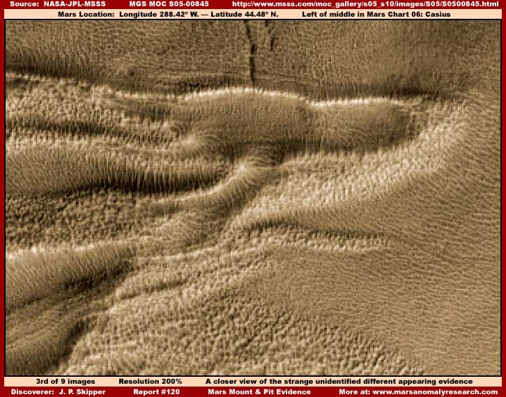
The above third image offers a closer view of what I consider to be the primary life evidence section extracted from the first and second image scenes. As you can see, the great many tendrils or branchings sticking out all over as thick as thick fur on a dogs back are the most obvious and dramatic evidence visuals. Note how there is also shorter upright knobby very uniform height looking evidence all around and on the right how the dense sea of clearly directional smoother finer evidence coming down the pit interior slopes appears to possibly be trying to engulf it.
This is obviously the most dramatic looking evidence site in this report and the reason that I used it as the front page thumbnail and why I consider it the life primary evidence here. I believe we are looking at life of some unknown kind proliferating into super high density and completely covering the terrain in this isolated island like pit environment. I suspect that this intense life proliferation is driven by very plentiful ground water and unique geological terrain chemical conditions in this mount/pit microcosm but more on that later.
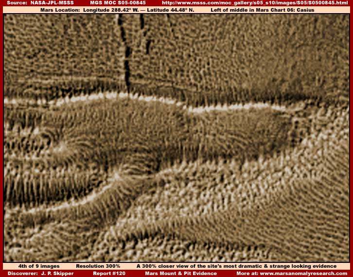
The above fourth image is able to bring the primary evidence out even more because it is so large and overcomes the official image poor resolution a bit more than other adjacent evidence. It looks in this tighter focus sort of like some giant beast laying there but isn't that. The main point though is do you see anything that looks like rock and soil geology down there? No? Well I don't either. It is fairly obvious that we are looking at a super dense proliferation of life of some unknown kind here on Mars and not geology. The fact is that the true terrain geology is hidden under all this. I will say that, if this isn't life, then I'm a monkey's uncle! Okay maybe I should have used some other analogy as I'm sure some will call me worse but you get the picture.
Remember, this is on another world within practical contact distance of Earth. Incredible, fantastic looking, and exciting isn't it. This is what space exploration should be all about as man explores the strange wonders that are out there around us accepting both the same and the new into our consideration with equal enthusiasm. Evidence like this may intimidate some but it has the capacity to lift the spirit of so many more just to know. Yet, secrecy and wide spread social denial would deny exploration like this to you even though you are the ones who paid for it and it is legally your information and not that of this or any Earth government, agency, private enterprise, elitism communities, or particular segment of society.
This represents what Earth humanity's destiny of discovery and challenge among the stars and our greater environment is all about, not the mindless ignorance and pabulum we are being overwhelmingly fed in our every day lives here at home to dull our senses and inhibit questioning anything. This space exploration and its knowledge gained is not the private preserve of an elitism few bent on control or the many bent on avoidance and denial. What this strange evidence represents is difference, wonder and growth not fear and withdrawal as how some would have us regard it ostensibly for our own good. I know it is not for my good but you must decide that for yourself.
The above fifth image is another scene in the pit just down slightly from the above 1-4 image scenes. Here we see more of the tendril evidence in the top of the image, more of the poorly seen knobby evidence in the mid areas, some band evidence conforming likely to winding folds and contours in the underlying terrain, and in the lower left corner a different type of more massive evidence mounding up in a higher elevation. All different and equally strange looking.
The above fifth image is included here just to demonstrate more of the evidence textures and patterns of the different types of nearby evidence located inside this big round walled shallow pit in the terrain. Now this isn't all the different evidence by any stretch of the imagination either in this large pit depression on in this strip but this strip has been compromised with poor resolution and about the only evidence that visually comes through to us reasonably well is that in the third and fourth images because of the large object sizes involved.
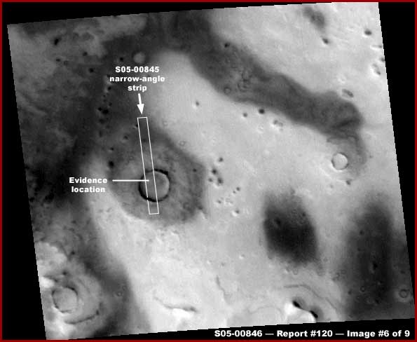
The above sixth image is the S05-00845 narrow-angle strip's companion S05-00846 wide-angle strip showing the location of the narrow-angle strip within it and the location of the evidence site within the crater like pit as imaged here in this report. As you can see, it is a fairly decent size crater looking geology and doesn't appear very deep within the pit area. Note what appears to be a ejecta field of uniform distributions around the pit and the sharp raised but thin rim.
Now I can't talk much about the fuzzy wuzzy life evidence best viewed in images #3 and #4 but I do have some geological observations and opinions that I would like to share with you about the mount/pit itself, others like it, and the terrain in this region on Mars that such mount/pits exist in. Why? Because this may eventually be germane to some understanding as to what is going on life wise inside this particular pit as well as the unique characteristics of this general area of the planet.
First let me start by telling you that I believe a lot of this regional area on Mars is basically a fairly level plain that was once covered by very shallow surface water sea in the recent past. In the recent planetary warming trend this water having no where to go in these level conditions may be slowly evaporating and was likely never deep to start with. I suspect that, if one had the strength for it and when more water was present in the past, one could have perhaps walked hundreds of miles without getting more than waste deep, if that. In some places there is still some very shallow water but most of the water left is just below the surface in many places with the ground a mud like consistency. Some areas are like this while others are more dry and with harder surfaces.
In the above fifth image, I suspect that the very light reflective areas may be very thin layers of stagnant water/mud either present or recently present where not much in the way of open air life can yet survive. I suspect the darker solar light absorbing areas in the fifth image are where patches of small scale life is establishing a struggling presence more than likely where a slight ground elevation and dryer ground makes conditions just a bit more favorable. Now look at the above pit again. The assumption of course would no doubt be that it is a impact crater but I don't believe this is the case.
The ejecta pattern around outside the pit is just too tight-in and uniformly equally distributed to adequately support the violence of an meteor impact scenario, including even in muddy power absorbing terrain. Space hard objects often come down at oblique angles and the impact site and the resulting ejecta field reflect this in the ejecta distribution patterns. The surrounding ejecta field here and with so many others like it is just too uniform in its tight-in surrounding distribution pattern around the mount and this is a key identification factor for this evidence. Further, it also doesn't adequately coincide with strong lava outflows in what we know of volcanism either. Strong mount building lava flows are a more violent expansion force that tends to seek the path of least resistance and is more directional in its travel and there is just insufficient signs of that here in this type of mount and pit evidence.
The truth is that the pit looks more like it was formed by some colossal hard round object being pushed steadily but fairly gently and directly down steadily displacing mud with its semi-flow qualities slowly piling up evenly around the outside of the growing pit in a less violent manner as compared to an impact crater or lava flow scenario and then water and flowing mud partially filled back up the pit after the object was removed. Of course that is almost certainly impossible and further doesn't explain the perfectly round hard thin rim but then neither is any of this adequately explained by hard object impact or volcanism scenarios either, not by a long shot.
Remember, this is a more or less geologically level plain and I suspect geological underground chemical action produced gases are periodically escaping as fairly cohesive large muddy bubbles gradually to the surface with the water saturated earth components (mud) being pushed up from below and piling up at a slower pace fairly evenly around the blow hole and then partially filling the blow hole back up when the underlying bubbling pressure subsides and the raised material with flow qualities settles back inside. The harder elevated thin rim is formed as drying is faster at this highest mount elevation and over time the softer sediment constituting it erodes away down the mount's always mild slope.
The result is a generally round somewhat elevated earth material mount or cone with a shallow round pit always at the center that accommodated the size of the giant bubbles rising and escaping. In other words, a slowmo geological process unique to Mars water saturated level plain muddy conditions. When this process happens only very rarely and a bit more in the distant past, you have the shallow mud made mount you see above in the fifth image with the darker light absorbing life really just beginning to take advantage of it like a more favorable island alone in a surrounding less hospitable sea environment.
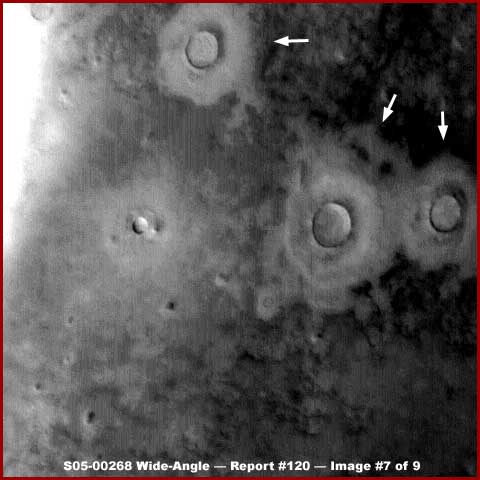
When the bubbles occur a little more often over time and/or more recently, you see a more raw solar light reflective shallow elevated mount/cone and ejecta field that darker light absorbing life has yet to establish a sufficient foot hold on again. The above seventh image from the different S05-00268 wide-angle strip demonstrates three large size examples of this more recent type of mount/cone/pit pointed out with arrows. These mount/cone/pit sites have cleared out an area around the blow holes in the midst of the surrounding darker light absorbing areas in the terrain that are in the case of the above seventh image likely bio-life far too small to be seen as objects in this distant wide-angle poor resolution imaging that can only define really huge size objects.
When this process has happened in the much more distant past and there has been a long more stable lapse of time without a more recent outflow occurrence, the mount/pit sites serve as starter islands of life. These gradually get thicker and thicker spreading out over time into the wider terrain and joining up with other growth fields there, especially when this happens in already slightly elevated terrain that becomes generally more elevated with the creation of the mounts creation process.
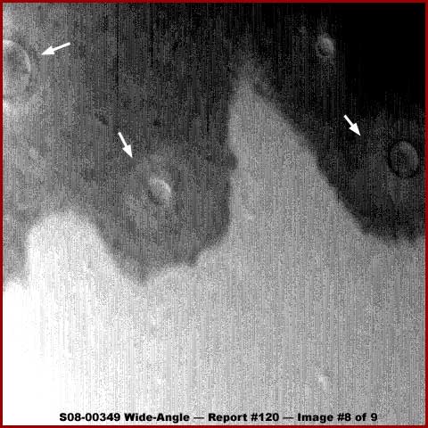
Remember too that not all underground upward pressures may be strong enough to breach the surface but may only slightly bulge and elevate the ground surface over them forming more favorable conditions to bio-life on that elevated surface. The above eighth image from the different S08-00349 wide-angle strip demonstrates this longer term process as darker light absorbing life spreads out from the mount islands when terrain elevation is more favorable but is still inhibited in the more water/chemical saturated very solar light reflective areas forming a distinct sharp boundary between the two light and dark areas.
What you also need to not forget is that there are of course true impact crater pits in this region but the type or eruption evidence I am reporting on here are much more plentiful. I have presented one theory here as to the mount/pit sites origins based on a number of years of exposure and thought regarding this evidence but I could of course be wrong. That evidence and experience tells me that there are large areas of very shallow water and/or mud flats present here all across this region and that water saturated muddy soil conditions play some kind of role in the creation of these mount/pit sites.
Of course the scientists would no doubt be quick to point out that where I see mud regions, they see dry desolate deserts explaining the highly light reflective terrain devoid of life. Also, where I see tight pattern mud created ejecta fields at the base of the mounts created by minimal outflow violence, they see impact craters and their ejecta fields or at the very least geological lava outflow ejecta fields. Likewise, where I see bio-life in the darker areas, they see merely differing soil compositions. Just remember, these are all theories, mine and theirs, and are not to be confused with true fact on either side. The only fact here is that these very distinct and strange looking mount and pit sites exist in plenty as visually captured in the satellite imaging represented by the too few examples here and their existence is not easily explained in conventional Earth terms.
As I say, these mount and pit sites discussed here are visually very distinct. One can always identify them by the relatively tight close-in and uniform ejecta field around the pits as well as the center thin hard rim and especially the consistently shallow relatively level bottoms of the pits that are rarely the deeper pits typical of impact craters. Now there are other round pits on Mars that are also clearly not impact craters even though they are often incorrectly confused with same because of the much deeper depth of the pits. They have their own unique explanations but here in this relatively level plains locale on Mars this evidence is quite different in origin.
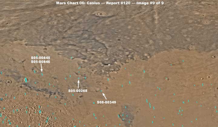
The above ninth and last image in this report is the reduced size MGS MOC Mars Chart 06: Casius for the s05_s10 image set. Note the location of the various image strips used as evidence here as pointed out with the white arrows and text labeling. However, more important, note the darker color area stretching all the way across the top half of the image and the lighter color area in the bottom half of the image.
Now in the darker upper area look closer and please note the many subtle light color roundish spots scattered all over. Some of these are impact craters but most are the mount/pit type evidence that I have been reporting on here. This gives you an idea of just how plentiful this type of evidence is in this region. The official explanation would no doubt be that these different colored fields can be explained by differing soil compositions. However I suspect the darker upper area represents slightly elevated terrain probably helped in this regard by the ongoing underground upward pressure action more plentiful in this darker area as described here and the establishment of darker light absorbing bio-life on this ground over time.
The lower more solar light reflective areas in turn represents the last remnant of this old shallow water system where it has been pushed down to as a more exposed geology that is less hospitable to bio-life. Also, as you can see, there is a distinct shoreline like broken up dividing line between the two areas. You should know that the pronounced visual demarcation line extends far out to the right and left many hundreds of miles into and across other adjacent regional maps. In my opinion, it is a boundary between geology being covered over by bio-life above the boundary line and less bio-life and more light reflective bare geology below the boundary line.
So what does any of this have to do with the unidentified evidence as best depicted in report image #3 and #4 here? I just wanted you to understand the likely geology and ecology framework that the evidence in the bottom of this S05-00845 strip pit exists within. It is likely that the wide floor of this pit is water infused geology more favorable to life we are more familiar with. On the other hand, it is quite possible that the mount and floor of this pit demonstrates isolated chemical composition unique in part to the subterranean geology that produced them and that any bio-life here may be unique to these unique geological conditions resulting in isolated life forms unfamiliar to the Earth human eye and perhaps unique and unusual even on this planet. Remember, life always finds a way.
The truth is that the Mars bio-life in general has many forms that we could recognize here on Earth if we could see them adequately on Mars but compromised obfuscated imaging puts a real inhibitor on that. However, Mars also has plentiful bio-life unique to its general environment that is often very hard for we Earth humans to recognize as life in this obfuscated imaging as well as unknown bio-life that has no parallel on Earth but is still unmistakably recognizable as life. When my first book and its surface water and bio-life evidence comes out, you will see stunning examples I've been holding back of totally unfamiliar but still at the same time unmistakably recognizable as unidentified bio-life evidence.
By the way, should any of you wish to explore the area above or below but especially above the boundary line in this northern hemisphere band around the planet, be prepared for a long drawn out arduous process. By far most of the images in this area on Mars are characterized by extreme obfuscation tactics to prevent any decent examination of anything and I do mean anything. The most prevalent is severe grain in the images insuring this result. This problematic imaging is present here to a far greater extent than any where else on the planet and it is true regardless of the image set being investigated, so it is most definitely planet area specific and therefore cannot be attributed to general imaging problems or certain satellite revolutions around the planet.
I encountered this very early in my work soon after the MGS MOC initial release in year 2000. As little as I knew back then in the beginning, I still knew this was impossible and therefore had to be intentional. Many thousands of images are like this, so be prepared for it. Early on I heard scientists complaining and wondering why there was so much "sand" covering this northern hemisphere band? Sand? You've just got to be kidding! At first I shook my head and couldn't believe it but since then I've sadly had no choice but to get used to the depth of this denial and self delusion business in the human psyche and in such well educated professional fields.
On the other hand, a tour through some of this data from this area, especially above the boundary line, is still worth while. The narrow-angle images with what should have been better resolution are of course the most heavily effected by the obfuscation and are not going to be very productive but the more distant poorer quality regional companion wide-angle images are a little less effected. In the wide-angle imaging you will see a great many of these large mounts and pits that I discuss here as well as normal impact craters with this gained familiarity giving one insight into the distinction between such evidence. It will also give you an overall geological picture of the dynamic nature of this part of Mars.
This geologically unique and dynamic wide-area environment in this Mars northern hemisphere locale goes a long way in shaping the bio-life that exists there and likely specifically in this S05-00845 pit depression. Of course the scientific consensus opinion will be that all of this is quite impossible. I can hear it now, mud? MUD on Mars? Have you lost your mind! Even so, suggest you use your own common sense and decide for yourself what may be probable and what may not be. At least the issue and my opinions are initially out on the table for consideration now. It's now up to others to follow up on this.
DOCUMENTATION
http://www.msss.com/moc_gallery/s05_s10/images/S05/S0500845.html: This link takes you to the official S05-00845 narrow-angle science data image that is the source of my 1-4 images here in this report. This link also takes you to the official companion S05-00846 wide-angle science data image that is the source of 5th image here in this report.
http://www.msss.com/moc_gallery/s05_s10/images/S05/S0500268.html: This link takes you to the official S05-00268 wide-angle science data image that is the source of my 6th image here in this report.
http://www.msss.com/moc_gallery/s05_s10/images/S08/S0800349.html: This link takes you to the official S08-00349 wide-angle science data image that is the source of my 7th image here in this report.
http://www.msss.com/moc_gallery/s05_s10/mc06.html: This link takes you to the official "Mars Chart 06: Casius" that is the source of my 8th image here in this report.
, Investigator
![]()