
MARS MYSTERIOUS DARK HOLE
Report #121
June 14, 2007
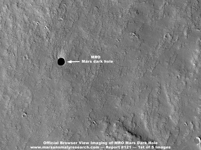
According to my email feedback, it appears that quite a few viewers are interested in the mysterious dark hole or cavern on Mars recently reported from the MRO imaging a few weeks ago. The above first image is the official science data MRO browser compatible image without any enhancements in it by me. All I've done is put some labels in it and reduced its size by only 10% to better fit this reporting page. As you can see, it is merely a round dark spot in an otherwise fairly level looking terrain but it has apparently generated quite a bit of interest and also debate.
It is the latter factor that has drawn my opinion and two cents into this as viewers keep wanting me to comment on this. I have been reluctant to do much with this because at my first glance this subject matter appeared to be too inconclusive in nature. Further, it appeared to be something that I might likely wind up reporting about nothing but image tampering on. I'm tired of doing that and, believe it or not, I try to avoid that where I can. On the other hand, viewer persistence caused me to take a closer look and so what follows is my small contribution to this issue.
The truth is that this is not a new discovery in the MRO imaging but a discovery originally made but poorly seen in the older Themis imaging now perhaps confirmed by the current much higher resolution MRO imaging. The mysterious dark spot you see above in the MRO imaging is speculated to be a dark hole in the Mars terrain that is so large and deep that very little light is reflected back out of it. It is suppose to be about the length of a football field across which would roughly be about 100 yards. It is actually just one of seven such pits or holes discovered in the Themis imaging and they are known collectively as the "Seven Sisters" and this site is the smaller of those They are all named and this one in the MRO imaging is named "Jeanne."
The Seven Sister evidence reportedly exists on the exterior flanks of the Arsis Mons volcano system terrain elevation. This is one of three volcanos oriented in a linear line and the three together are known as the Tharsis Montes and exist on what is known as the Tharsis Rise and of course the region in general is known as the Tharsis Region. Arsis Mons is the second largest volcano system on Mars with nearby Olympus Mons being the largest by far as well as the largest known in the Solar System dwarfing anything on Earth.
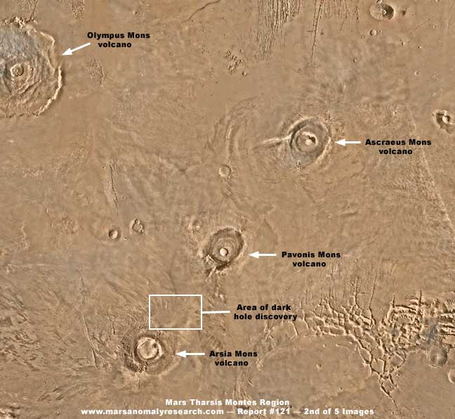
The above second image shows the general Tharsis Region with the mentioned volcanoes pointed out with labeling. Note also that the general area of the "Jeanne" cavern or pit is outlined in a box. The rough patch of terrain in the lower right corner of the image is the western end of the great colossal crack system on Mars. Obviously, this general area has been very geologically active in the past.
The "Jeanne" pit is definitely not an impact crater because the pit surroundings show no presence of an ejecta field. If this discovery is real, it is thought by some scientists to be a site where the top of some huge underground cavern formed in hard strata has collapsed and fell in leaving this hole or "skylight" in the cavern roof. I'm reminded that something that acts very much like this are what are known as "blue holes" here on Earth but these sites are usually submerged in water and their surviving cantilevered partial roofs are partially supported by that water. Obviously these pits proximity to the volcano system geology give some added support to the scientific giant hole speculation because such huge underground caverns could have been formed due to the past subterranean volcanic activity.
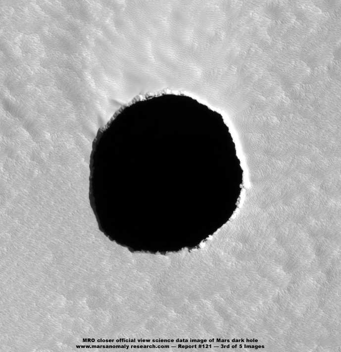
The above third image is the same dark hole taken from the MRO imaging but this time from the official large file size high resolution image and again has no clarification work in it by me. As you can see, it accentuates the dark hole but at the same time subdues the detail in the surrounding terrain via light color over-saturation and haze. It's sort of like the shell and pea misdirection con game. When I see that happen, I always start getting suspicious because it suggests the possibility that someone wants us to look at the hole and nothing else. Dark blank areas standing out in such sharp contrast to their obscured surroundings are great for stimulating speculation about the subject they want you to focus on but ultimately lead no where. I'm also reminded that such misdirection is just fine in some quarters.
I must tell you that I have examined this dark area very closely. In my opinion, the dark area is not shadow but a inky dark application. It will not respond to lightening even a tiny bit as true shadow normally would, at least to some small degree. Now don't get me wrong, there may very well be pit here but its interior appears to me to be blotted out by an application. Why? Well I can't know that with certainty.
Also, what little can be seen of the interior wall of this pit just doesn't add up. If it is a cantilevered wall tapering back away from the hole edge, what little of the interior vertical wall thickness we can see is just too thin to support itself if it tapers back out of sight under the roof into a very deep cavern in a way that might swallow up all light and that is the only kind of geology that could explain not reflecting back any light at all. If there was any slope at all downward in this pit, including straight down or with a lesser taper back away from the opening, we should still be able to see some of it in shadow here and yet it isn't there. This brings me back again to the likelihood that the dark area itself is an artificial application and not shadow at all.
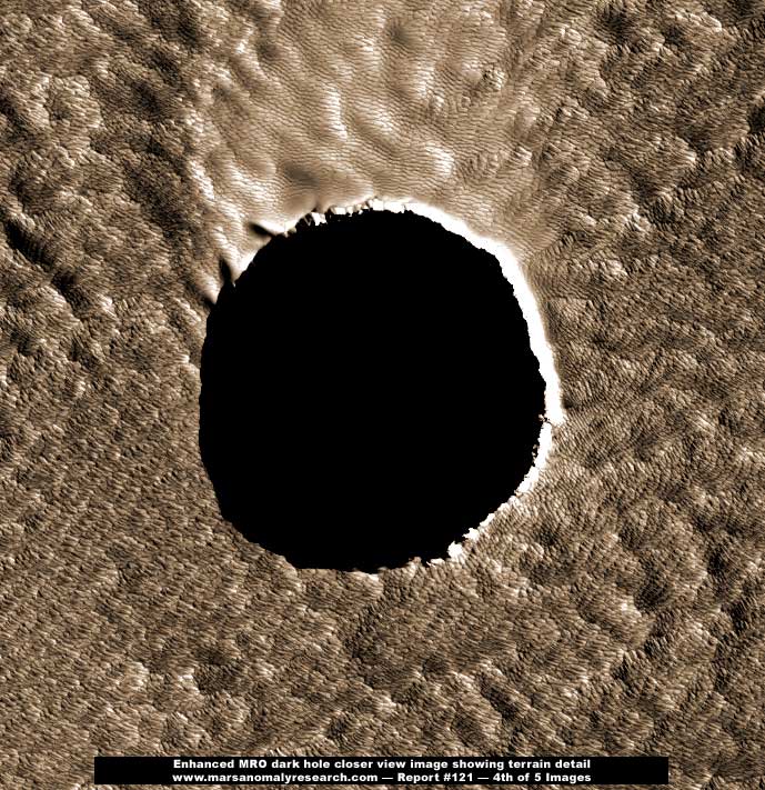
Then there is the above fourth image which is merely the third image with clarification work in it by me to bring out the terrain detail at the expense of the dark "pit" area detail. As you can see, now that we can see the terrain better, it takes on a whole new aspect and the direction of interest is shifted as well to a wider scope inclusive of the terrain.
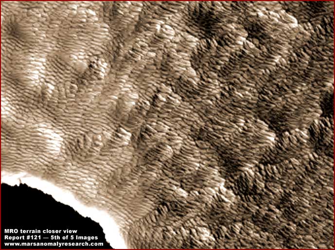
The above 5th and last image is an enlargement of the upper right sector of the fourth image. It demonstrates a closer view of the unusual terrain details and, since it pretty much speaks for itself, there's not much more that I can add to it.
Now I don't claim to know conclusively what we are looking at here but, if it is geology, it is certainly some of the strangest looking terrain geology I've ever seen, including on Mars. In fact, although I'm sure that most scientists would say that this is just a lava flow field appearing in many multiple folds, I just don't think that we're looking at geology with these organized uniform patterns repeating themselves over and over gain in the thousands. Further, the fact that this kind of highly interesting surrounding terrain evidence was not just officially ignored but obscured is troubling and suggestive of a hidden agenda to say the least.
Now, among the things that don't add up, consider the sunlight direction. If we assume that this is a pit or hole, then the coloration around the edge of the hole indicates that the sun angle is coming from the lower left to the upper right as demonstrated by the brightness on the hole's upper right thin interior wall surface. Yet, look at the rougher appearing terrain in the upper left of the image. Note that what little shadow is formed there denies this scenario. On the other hand, if the original object here was an elevated form rather than a pit with 99% of it covered over by a inky dark application except for just a little perimeter edge material, then the sun angle would be coming from the opposite direction upper right to the lower left illuminating the tiny portion of the elevated formation's base left out of the application. Further, what little darker shadow is present in the rougher upper left terrain tends to agree with this scenario.
The question then becomes what is really going on here? Has someone not only hidden some rounded and huge elevated form here with a dark inky application conforming to most of its dimensions but have they also done so in such a way that it points thinking and analysis subtly in the exact opposite direction (down rather than up) of what is really present there? When one sees a dark inky round spot in the terrain and the terrain detail is thoroughly obscured and one trusts the source visuals implicitly, one automatically thinks in terms of a hole and subsequent analysis tends to run with that concept just as these trusting scientists have done. But, is the pea really under that particular shell? Are we being manipulated?
Just for the sake of argument, try this scenario on. What if there was a big elevated round dome here sitting on top of a elevated artificial rocky base and also sitting within a sea of surrounding super dense special bred biological life as a food supply and/or a research site? Suppose that dome was reasonably clear due to MRO's advanced resolution imaging and geometric objects could be visually seen inside it making it a prime candidate for the now more advanced tampering software to easily see and recognize as a candidate for its applications. So what happens is an elevated form is not only eliminated, it becomes a pit and the telling terrain detail gets obscured. Think about it.
The bottom line is that there is insufficient evidence of any of this one way or the other as to whether this is truly a pit or originally an elevated form. Except for the strange looking terrain that I suspect is more "suggestive" of some form of strange dense biological life than inanimate geology, the fact is that what ever is most telling here evidence wise has been visually eliminated by intent. The only thing that the less trusting of us are left with is the strong suspicion that we've been had and that the Mars dark hole scientific speculation may be off the mark with this particular evidence.
That kind of ambiguity may be disgusting and unacceptable to those of us longing for a little simple straight forward truth in planetary exploration but, even if the down versus up misdirection tactic and perception doesn't work with everyone, the resulting ambiguity alone will do just fine as a second choice for those who promote secrecy. Just trust us, we know what is best for you!
DOCUMENTATION
http://antwrp.gsfc.nasa.gov/apod/ap070528.html: This link takes you to the NASA official 5/28/07 public release with caption text of the basic MRO image of this discovery. Note that only the distant browser compatible image is available here.
http://hirise.1p1.arizona.edu/PSP_003647_1745: This link takes you to the official site for the release of the raw science data imaging. Both the browser compatible 1.3 MB and full size 441.2 MB images are available here as well as some statistics.
http://www.planetary.org/image/PSP_3647_1745_cut_b.jpg: This link takes you to the an enlarged browser compatible version of the image without the need to download the full size 441.2 MB image.
http://www.lpi.usra.edu/meetings/lpsc2007/pdf/1371.pdf: This link takes you to the discovering scientists statements with regard to what they interpret as a dark hole or cavern skylight.
http://en.wikipedia.org/wiki/Arsia_Mons: This link takes you to the useful online encyclopedia discussion of the Mars Arsia Mons volcano geology that also includes links relating to the Seven Sisters discovery sites associated with it.
, Investigator
![]()