
MARS STRANGE EVIDENCE-1
Report 130
November 18, 2007
As this report's title suggests, we'll take a look here at some unusual and odd but interesting Mars evidence that doesn't lend itself very well to quicker recognition or interpretation. Feel free to consider it and decide what you think about it.
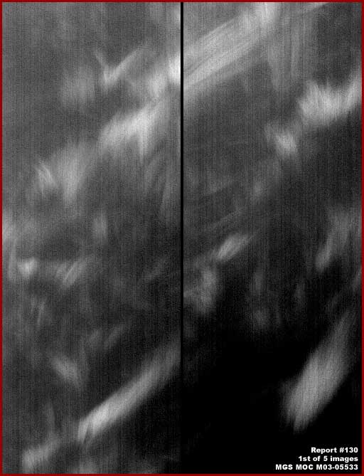
The above first image is from the upper 20-25% of the straight .gif MGS MOC M03-05533 narrow-angle strip. This location is well up on the North Polar Cap where a large deep depression cuts from the Cap's perimeter edge deep into the Cap main body. In this split image, the right panel represents the strip view immediately under the left panel.
It is hard to be sure in such a especially poor resolution image but it may be a phenomena in the atmosphere between the satellite camera and ground level. If so, it may simply represent sunlight reflecting off of patches of ice crystals at different layers in the Mars atmosphere. It may also represent a Mars atmospheric event similar to Earth's Northern Lights or Aurora Borealis in conjunction with the presence of atmospheric ice crystals but seen from above instead of from below? What ever it is, it is rare in the sense that this is the only image I've run across of this so far in many thousands of images.
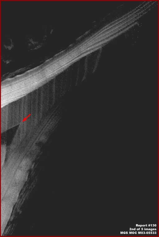
The above second image is from the upper mid area of the same straight .gif MGS MOC M03-05533 narrow-angle strip shown 2X its original official size. The scene in the strip is below that in the first image. As near as I can tell this scene is one demonstrating strange light color elevated and banded North Polar Cap terrain sticking out like a peninsula terminating into a great depression on either side that is not only in dark shadow in this image but the depression itself is covered in dark color material contributing further to the darkness.
The red arrow in the above second image points to dark wedge shape feature on the lighter color terrain material. I can't be conclusive as to what this is but I can tell you is that this feature is temporary and eventually fades from view as can be seen in the next third image below and is not present at all in other images of this spot. This poor image is included here only so that you understand that this terrain level evidence is in the same location of the evidence in the first image.
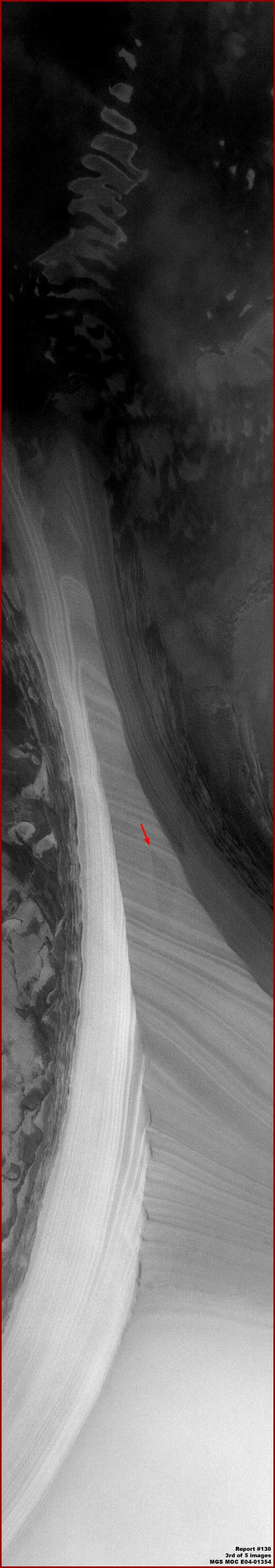
The above longer third image is from the lower mid area of the MGS MOC E04-01354 narrow-angle straight .gif strip and shown just as it appears in the original without any work in it by me other than the labels in the lower right corner and a narrow border. Be forewarned that the above scene can produce an optical illusion suggesting that the slightly darker color striped or banded material where the red arrow is located runs under the adjacent folded border material on either side of it.
However what is really doing on here is that all of the light color material seen here is an immense tapering peninsula sticking out into a great depression represented by darker terrain material. That isn't anomalous in of itself but the elevated massive peaked very sharp ridge top spine is anomalous since it appear likely to consist of ancient North Polar Cap frozen ice material rather than geological land mass.
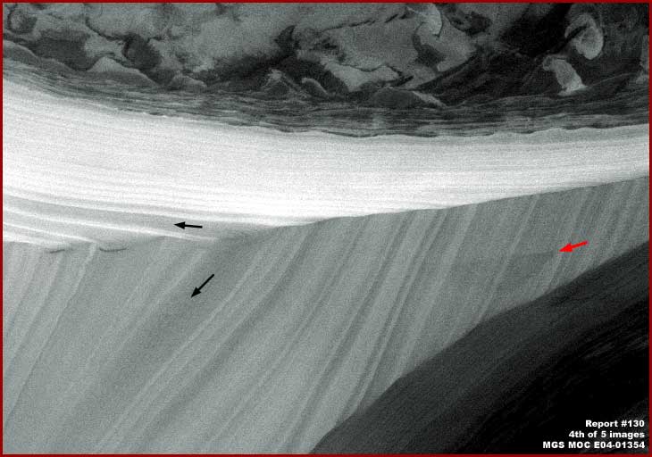
The above fourth image with its rotated 90º clockwise view of a section of the mass demonstrates this better. Note the stronger sunlight reflectivity factor on the far side of the ice mass slope and the ever so slightly darker shade on the near side confirming that this evidence is throwing a faint shadow and is elevated material. Remember that this is ice and a translucent material. That means that any shadow on the near side would be minimized by a certain amount of sunlight passing through the body of ice from the far side to the near side.
Further, the banded mass must be very hard to sustain that very sharply defined ridge line. The two black arrows within one of the many bands in the material also demonstrate via the same band's presence on both sides that both sides are the same mass material, that two steep slopes are present, and that this evidence is massively tall and elevated.
The red arrow once again points out the dark wedge shape feature on the ice mass seen in the above second image. As you can see, here it is substantially faded and much less sharply defined. At least some of the reason for that is no doubt because its presence as a dark sharply defined feature in the second image above from the M03-05533 strip is because that image was taken on 7/28/1999 and the more faded E04-01354 image of the feature was taken almost 22 months later on 5/18/2001 according to the official statistics.
How this dark wedge shaped evidence in such a sharply defined configuration could even get on the near side of this very steep slope and on such obviously uniformly pure hard material and even at right angle to the steep slope direction is a mystery. If it was a spout of some kind, the steep slope and gravity would surely have had considerble more down slope effect on the orientation of the wedge shape stain.
On the other hand, if it is the result of something flying at speed horizontally across the landscape and it struck the slope a glancing blow creating a dark staining debris field further on at right angle to the slope, that might answer the stain orientation at right angle to the steep slope but then why isn't there any noticeable damage to the slope material otherwise? Was the object that soft or is the slope that hard? Was this a soft but large flying mushroom like object full of inner dark spores and navigation confused by the strange atmospheric display overhead? He! He! Can you say splat! Or was it a hard meteorite slamming into something too super hard to scratch? Is it possible that this isn't ice at all but something else massive but camouflaged as polar material? Yes, plenty of questions but too few answers.
However, another mystery is the light color material itself and its banding. Now banding in Polar Cap ice material is nothing new and quite familiar here on Earth. Snow falls and collects on Polar Cap horizontal surfaces forming lighter color layers. Atmospheric dust and sediment particulate falls an collects on Polar Cap horizontal surfaces forming subtly darker color layers. Cut vertically at right angle through these multiple horizontal layers and horizontal banding in varying thicknesses is apparent. That is very possibly similar to what we are looking at here but how can this banding be in what appears to be nearly vertical configured layers? It is almost as though the ice and its layers were extruded from one location to another eventually piling up in more vertically oriented folds.

Speaking of folds, check out the above fifth image once again from the M03-05533 strip same as the first and second images. This strip swath is a location angled just to the right of that in the E04-01354 strip. The scene at the top of this image is the same as in the second image but here showing a lot of Cap terrain below that peninsula. As you scroll down the image, you see the many parallel lines in the near vicinity of the dark depression that get more well defined going down the image until they give out in the Polar cap material that is level and not banded.
It is difficult to determine such things from these narrow 2-dimensional imaging slices of the terrain but I'll tell you what I suspect may be happening here. I suspect the very light color and more level material at the bottom of the third and fifth images is normal polar cap snow/ice accumulating in horizontal layers just as it does at our Earth's poles and it is the highest elevation of any of the other terrain seen here. This height is just not readily apparent to the eye because the poor black and white imaging combined with the level bright reflective quality of the snow/ice terrain just obscures too much detail for this to be more readily apparent.
In the above fifth image, as the eye moves up the strip away from the level terrain at the bottom and over the parallel bands to the dark area near the top, the terrain is gradually dropping as one moves closer to the dark depression. What appears to be banding is actually broad terraces eroding away down hill toward the depression as one moves up the image. The terraces are caused because the layer of snow/ice melts and erodes more readily than the layers of sediment that are more resistive and so the many accumulated horizontal layer edges are exposed at the sediment layers. Very near the depression the terraces appear bunched closer together because the grade of the slope gets much steeper there dropping into the depression.
The very sharp spine ridge of snow/ice material with the impact stain on it seen in the third and fourth images has the same thing happening to it as well except that steep slope compound angles are involved. In that evidence we are seeing the ridge spine going down even though that isn't readily apparent without a wider context view. Also, because it is a peninsula sticking out into the depression, there are three different slopes involved, the ridge downward slope from the elevated but level polar field and the two downward slopes off of each side of the ridge spine. The compound slopes involved causes the layers/bands to appear more vertically oriented in the imaging but they are not really.
You'll note that all of this evidence is much more consistent with the behavior of slow melt snow/ice melt water conditions as opposed to carbon dioxide (CO2) snow/ice evaporation or sublimation. Further, I strongly suspect that the dark terrain in the depression not sufficiently explained by shadow (and there's plenty of that) and too distant to see the details of here is explained by Mars low growing cold hardy ground cover growth thriving on the damp conditions inside the depression fed by the slow snow/ice melt from the surrounding terrain. The growth is of course all very dark in color to absorb as much solar energy as possible. Likewise, the partial release of some of that solar energy would warm the air in the depression a bit relative to the surrounding snow/ice encouraging continuing melt conditions there.
In other words, a self sustaining but likely fairly isolated ecology within the surrounding more permanent polar cap material. One should also know that very nearby is a very large very dark cut extending from the polar cap boundary edge deep into the cap to this area. It is difficult to tell in the visual data but this depression may even be a part of that cut system. If that huge dark cut also has bio-life in it, via spore activity, that could explain the presence of similar bio-life presence in this depression.
So it is not outlandish after all to speculate that what ever struck the depression side wall of that very tall ice ridge and staining it may have very well originated from within the depression or cut system and represent something organic. Could it be that organic spore life inside isolated ecology's like this on the Mars North Polar Cap have developed a strategy of rocketing spore packets out of depressions like this for distance to chance reaching other similar nearby isolated depressions and this packet went off track impact this tall barrier?
DOCUMENTATION
http://www.msss.com/moc_gallery/ab1_m04/images/M0305533.html: This link takes you to the official MGS MOC M03-05533 narrow-angle science data strip and the straight .gif strip that I sourced from for my 1st, 2nd, and 5th report images. Please note that only the third listed browser compatible straight .GIF strip works at this location and that is the one my report imaging is sourced from.
http://www.msss.com/moc_gallery/e01_e06/images/E04/E0401354.html: This link takes you to the official MGS MOC E04-01354 narrow-angle science data strip and the straight .gif strip there that I sourced from for my 3rd and 4th report images.
, Investigator
![]()