
MARS ATHABASCA VALLES
Report #144
August 5, 2008
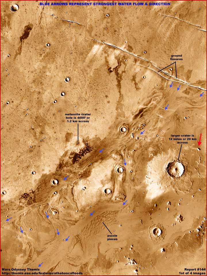
The above image provides a context view of the evidence scene which is this case is the entire original Mars Odyssey THEMIS science data strip but here reduced to 30% of its original size. Now the basic artificial color in this image has already been added at official level and is not my work while the arrows and labels added are my work. Now before getting further into this report commentary, please go to the official link below and read the official lengthy comments on this particular locale applying mostly to its geological features and properties.
http://themis.asu.edu/features/athabascafloods
As per the official
commentary, this general area is influenced by volcanic changes. This influence
formed lengthy narrow fissures across the terrain. At this site and others
nearby, over periods of time in the ancient past liquid water (as well as
lava) has gushed out of the fissures pointed out by the black arrows and text
in the northeast or upper right corner of the image and flowed down slope
southwest from the upper right to the lower left. The paths of the stronger
water flows eroding the terrain are obvious and marked in the image by the
blue arrows.
The size of two of the craters in this scene is given and in the official
text and reflected in the above image labeling. Note that the largest crater
at the mid-right is some 12 miles or 20 km across. This reminds us that this
image offers a very distant view. That means that objects down there appear
normal size but are actually very much larger as only huge objects can be
adequately seen.
Now my reporting here does not disagree with the official reporting. The visual
evidence supports the fissure water outflows and the terrain erosion as the
flows traveled from northeast to southwest. On the other hand, the intensity
of the larger crater shadows is considerably less than the late afternoon
shadows cast by the many smaller objects in the terrain all around them indicate.
The exact opposite should be true of the more massive elevated objects like
the craters that should be throwing long intense shadows but aren't. The largest
crater is the most guilty of this. This is a clue that some of this terrain
has been visually manipulated and may not be entirely trustworthy.
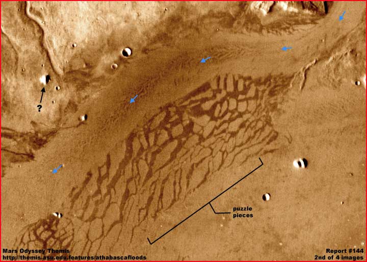
The above second
image demonstrates what the official science commentary had labeled "puzzle
pieces." The main consensus theory is that these huge blocks were once
cooling and hardening lava rock riding on top of hotter more fluid lava layers
below. On this shifting and unstable lower level surface, the surface cooling
and hardening upper layers cracked forming into these huge titanic blocks.
It is just some geological information thrown in here in this reporting for
its interest factor.
On the other hand, note the fairly heavily eroded water course pointed out
by the blue arrows and its path. Note that in the upper areas the water flow
was deflected around the area of huge broken up blocks. Obviously, the water
flow and its erosion happened after the time of the lava blocks presence and
just as clearly the lava blocks represent elevated terrain partially blocking
and deflecting the water flow path.
At the same time, note that all of the separations or great cracks between
the blocks are oriented in an angled downward direction that would have allowed
some of the rushing water to have been diverted into their maze. In fact,
the crack direction orientation suggests it is likely that the rushing water
helped carved out these gaps or separations between the blocks and in some
part likely became trapped in this maze. Therefore, although we can't see
it here, it is quite possible that the deeper depths of these many cracks
between these titanic blocks may contain residual water from the flows.
 ..
..
 ..
..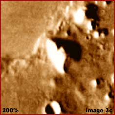
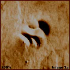
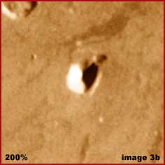
The above three images show some unusual smaller (but not small) terrain surface forms and demonstrates their lengthy intense shadows in this THEMIS imaging. As you can see, except possibly for the middle #3b image, the shadows are pronounced in the late afternoon sunlight but don't seem to always agree with the object throwing them. Now remember that this is infrared imaging, so the lighter color the object, the more heat it is generating in the infrared and the cooler it is with the darker colors. This tends to wash out detail on the hotter signature objects preventing us from getting a good look at it.
 ..
.. ..
..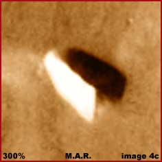
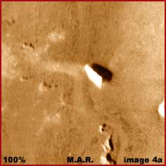
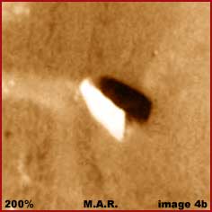
The next above
three images show another bright reflective object casting a shadow but viewed
at three different 100%, 200% and 300% zoom factors. In the left more distant
view with less detail, this at first appears to be a surface based tall object
with a shadow radiating out from its based area on the left. However, something
just looks too wrong with this picture the closer it is observed.
Note the shadow at the upper left end of the object and how the shadow end
rounds matching the round end shape of the object but notice how it comes
back under the bright reflective object. This suggests that there is no connection
between the object and its shadow on the ground. In other words, the shadow
does not seem to be radiating out from a base area on the object as it does
with the object in the #3b image.
This in turn, despite the object appearing to
be on the ground on its long edge, suggests that the object is entirely in
the air suspended above its shadow. However, to get a better perspective in
this way, you would have to turn your head at such an angle risking a kink
in your neck. No need for that with the image below.
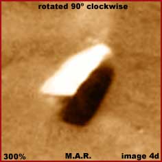
In the above next
image I've rotated the view 90º clockwise and that's all I've done. As
you can see, the impression that the bright reflective object is suspended
in the air relatively low above the ground and casting its shadow on the ground
is now considerably increased.
Once again don't you wish that we were looking at a regular optical image
instead of this infrared image where the heat signature of the sunlight reflective
upper surface of the solid object is washing out so much detail there on what
we now consider the top surface of the object? Which orientation do you believe
is the correct one relative to the visual evidence, the one officially provided,
or this rotated view? Which visually fits the available evidence better?
The obvious suggestion is that we may be looking at some kind of craft suspending
in the air low over this Mars terrain. Remember as well that this is distant
imaging and that this object is actually far larger than it appears here in
this image. This object at minimum would be the size of a super aircraft carrier
or a small town here on Earth.
Now the scientist's geology take on this THEMIS infrared image shown here
in the first part of this reporting is interesting and understandable. There
appears to be no deceit or obfuscation in their comments on their geological
analysis of this scene and that is consistent with their scientific specialty.
However, surely they are also men and women capable of using simple common
sense logic and reason beyond just the scope of their formal training?
The problems with the shadows and their inconsistencies drew me in to looking
closer. So why wouldn't it be the same for them since shadows are normally
a geological factor to be considered? How can one ignore much smaller objects
throwing strong pronounced afternoon shadows from their base areas out across
the terrain in the admitted late afternoon sunlight as shown in images 3b–3c
and yet much larger much more massive taller objects do not do so? It is a
mystery that should compel closer attention by any scientists, not turn it
away.
Once you begin to investigate the shadows in the strip, then the above evidence
of course must come into awareness. Do you really believe that NASA scientists
did not note the shadows problem and look closer? If you are a NASA scientist,
how can evidence like this in the #4a–#4d images just be ignored? Is
it because it just doesn't fit within the accepted mental paradigm box and
is therefore routinely disposed of in consciousness? Are our paid professionals
loosing the ability to question anything?
In any case, the above #4d image evidence, although not necessarily conclusive
proof of anything, is none-the-less far too suggestive and titillating to
just be so ignored. I thought it interesting and important enough to devote
a report to but you must decide for yourself what you think.
DOCUMENTATION
http://themis.asu.edu/features/athabascafloods:
This link takes you to the official Arizona State University Mars Odyssey
THEMIS science data image from which this report's evidence was extracted.
Note the red arrow in the very first context image in this report pointing
to the location of the primary #4a–#4d image evidence.
![]()