
EARTH COVERT FLYERS & AIRFIELDS-2
Report #165
July 26, 2009
In my 7/7/09 , which this report is a companion to, I covered too much different
subject matter in a single report. I knew it at the time but chose to do incomplete
reporting on the UFO evidence anyway. Why? Because I knew I would wind up
talking extensively about image manipulation factors in a more complete report.
I dislike that subject matter because I see so much of this, it is very involved,
and it starts bending attention away from the important evidence and onto
technical image manipulation issues.
However, this failure of mine to report fully left a technical opening with
respect to the UFO craft evidence in that prior report for adversaries to
later zero in on. Even though only a couple of viewers have picked up on this
issue and brought it to my attention so far, more adversarial work can be
expected in the future when the pressure of this work starts being felt in
earnest and adversaries start cranking up their reactions looking for anything
to argue about as a misdirection tactic. So in anticipation of that, here
is some more of my two cents on the UFO and its shadow evidence for that potential
future time.
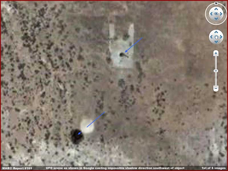
You see, in order for the UFO
and its shadow in the above Google Earth 1st image evidence to be an elevated
flying object casting a shadow on the ground, it requires a sun position to
be in the northeast relative to the UFO site causing the evidence to cast
a southwest shadow as demonstrated in the official view and as pointed out
by the slender blue arrows in the above 1st image here.
This evidence is in southwestern Nevada at roughly latitude 37º north.
Since the sun is to the south of this latitude and not north of the 37º
N. Latitude, then the UFO shadow could be considered impossible. You see the
vulnerability and their opening.
The argument could then be made that the white reflective object is not a
craft in the air at all but a reflective surface on the ground as is the dark
area adjacent to it. In other words, regardless of the general look of the
evidence, an apparently legitimate argument could be presented that it cannot
be an elevated airborne object of any kind due to shadow impossibility.
If someone at that future time wished to accuse me of making wild and foolish
claims, they could then point to that prior Report #164 as evidence by association
of my "wild" and "irresponsible" reporting. The transparency
factor of the dark area that is otherwise so consistent with ground shadow
would then just be dismissed as generally strange and anomalous.
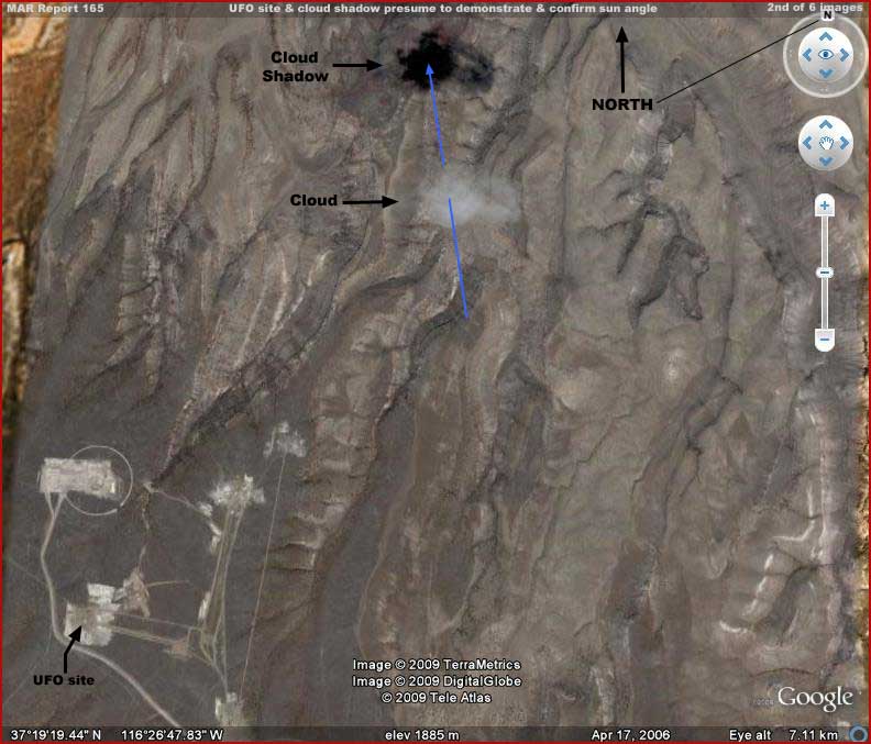
Now note the above 2nd image. This
much wider field of view and more distant scene includes the UFO evidence
site in the lower left corner as a very distant object and a single cloud
casting a shadow in the top center of the image. Note that the cloud shadow
position is north-by-northwest of the lone cloud and this would be more consistent
with what one might expect from a true late morning southern sun position
in the latitude 37º north locale.
When taken at purely face value, this nearby cloud and shadow evidence obviously
reinforces any argument that what has been identified as UFO evidence is not
an object in the air but actually discolorations on the ground and therefore
ground effects. Why? Because this nearby cloud shadow supposedly demonstrates
the sun's true southerly position making the UFO site dark area impossible
to be a shadow in comparison. It is after all the most simple and innocent
type of evidence as just a cloud and its shadow.
However, the key to such arguments is a matter of trust and taking the data
as officially presented in Google Earth at face value. Do you trust Google
Earth or more precisely those who supplied these images of the Area
51 area to Google Earth for display? It is the same with the space
exploration imaging of other worlds like the Moon and Mars. If you do sufficiently
trust the imaging sources, then you have your answer. In this particular case,
you must assume that the object in question is not something in the air but
something on the ground and, as such, not something anomalous. For so many
it is a comfort thing in that their prior trust assumptions need not be disturbed.
As for me, I admittedly do not trust and, in my opinion, no investigator or
researcher can do so and still be effective in getting at objective truth.
Further, everything I've seen in the last nine years of researching the space
exploration data has given me no reason to trust and, in fact, the exact opposite.
From my point of view, truth is hard to come by in the space exploration data
while obfuscation and misdirection is encountered in abundance. So, if you're
willing, let's look a little closer at this UFO issue beyond just what someone
has designed for us and wishes us to see.
Start by noting the gray color of the terrain in the above 2nd image. This
gray area is a narrow strip relative to others in Google Earth with stronger
color terrain on either side and you can see the edges of it on the right
and left sides of the image. This strip look tends to imply that all of this
gray color area is likely a single satellite imaging strip. Therefore, armed
with that assumption, one can in theory safely anticipate that what is evident
in one part of the "strip" can be counted on to be consistent in
other parts.
However, even though this conclusion was made easy for viewers and researchers
to accept, if you did assume this, then you need to think again. Someone is
playing head games here with these different color variations meant to influence
perception in this way. The gray "strip" area is actually a mosaic
of many images and the color is just an artificial introduction that seems
to be there only for manipulation of perception purposes to encourage such
misdirection assumptions.
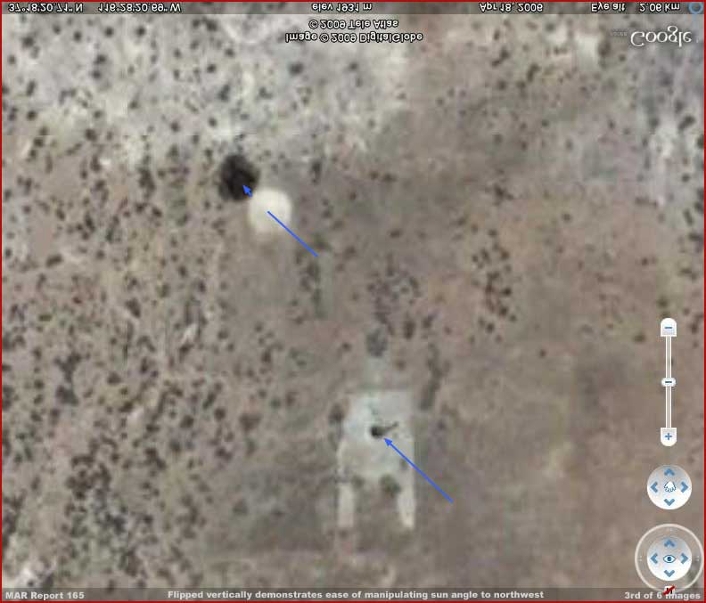
In the above 3rd image, I've just
simply flipped the 1st image vertically and I've done nothing else to it except
introduce some blue arrows representing the now changed sun angle. It was
as simple as the single click of a button. Note that the sun angle shadow
is now northwest relative to the white reflective object and this places the
sun position in the southeast.
So now the sun is in the right position for the object to be elevated off
the ground and the dark area to be a shadow on the ground. Now that wasn't
hard at all was it.
Note in the above 1st and 3rd images that there is also what appears to be
a dark tower in the center of a patch of ground disturbed area nearby the
UFO also pointed out with blue sun direction arrows. The sun position is high
and so any shadows thrown will be relatively short for ground based objects
such as this. Note the dark area at the base of the tower as likely shadow.
Although smaller size evidence like this is very blurry here relative to the
larger UFO object, note that it is very consistent as a shadow and that it
matches the direction of the UFO shadow. The FBI might call this a clue if
they weren't serving masters who would likely frown on such a truthful observation.
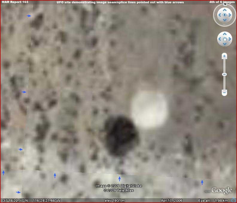
With respect to the flipping issue,
the above 4th image provides a closer view of the UFO site as it is officially
presented in Google Earth but with too much zoom factor so that everything
is much more blurry. The little short blue arrows point out the the seam or
splice lines near the UFO site running horizontally just south of it (below)
and vertically a little further west (left) of it. The seams define an image
mosaic section that includes the UFO site.
I could have increased the clarity to make these seam lines stand out more
prominent but I think you can still see them just fine and I wanted you to
see them as they appear in Google Earth should you attempt to replicate this
zoom factor in that program and check this evidence out for yourself. This
way you know what to look for and where. The truth is that some of this faint
splice line evidence can even be seen back up in the 1st report image here.
At this zoom factor in Google Earth, these splice lines can be followed in
a rectangular configuration around the site and they define the boundaries
of the mosaic image section the UFO evidence is located in. I didn't have
enough image room to show it here but the image mosaic section the UFO evidence
is in extends north to a point just beyond the disturbed ground area where
the dark tower is located and includes that evidence in the same image section.
The fact that both evidence sites share the same image section reveals why
the UFO and tower shadow agrees with the UFO shadow direction even if the
Google Earth presentation is actually a flipped view.
In other words, in my opinion, someone flipped vertically just the mosaic
image section that both the UFO and tower evidence are in. The reason was
so that the UFO scene would appear to provide what could later be debunked
as not a shadow at all because of the wrong sun position angle and this staged
and baited trap was supplied to Google Earth for display and for researchers
to find.
Now go back up to the 2nd image and take note of the diffuse nature of the
lone cloud that is suppose to reinforce the debunking tactical. Note how dark
and dense the cloud shadow on the ground is. Does this shadow seem real looking
to you? Although the shadow shape is faithful to the cloud shape, it just
doesn't otherwise look real to me but then I'm very suspicious.
In my opinion, there is no way that this diffuse cloud could throw such a
dense shadow on the ground. Further, that shadow is on rough mountain surfaces
with different surface angles and yet note that the shadow is unaffected by
these surface angles. It looks very much like a too dense 2-dimensional application
on a 3-dimensional background.
Further and tellingly, it is also the only cloud in a very wide area for hundreds
of miles or kilometers. Isn't it convenient that this lone cloud is so proximate
(not too close, not too far) to the UFO evidence site. Chance or intentional?
That of course depends on your level of trust.
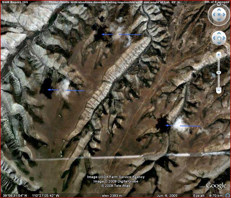
Now we come to the above 5th image
and its cloud shadow evidence. This evidence in Utah is not otherwise associated
with the UFO site evidence but it is important to and applies directly to
the trust issue.
Note that this evidence area is in northeast Utah at latitude 39º north
and well north of the UFO site's 37º north
latitude. Note that the dark shadows to the west (left) of the clouds indicate
a mid-morning eastern sun position but at 39º north latitude and this
too is quite impossible. To be true, it would mean that the sun position would
have to be far too far north roughly at latitude 39º north or well north
of the Tropic of Cancer.
Note that the shadows are again too dense and again on mountainous rough terrain
with different surface angles and yet once again the shadows are unaffected
by those different surface angles. Once again they look like 2-dimensional
applications on 3-dimentional backgrounds. Do you believe these clouds and
their shadows are real and not false graphic creations?
Here's another point and why I chose this particular cloud evidence in this
report. With this kind of cloud and shadow positioning and terrain, even if
I flipped them vertically or horizontally or any combination thereof, the
shadows will never become faithful to a southerly sun position and angle.
To achieve that I would have to rotate the scene clockwise or counter clockwise.
Further, if I did any of this kind of manipulation, unlike the conveniently
blurry relatively level terrain background at the UFO site in Nevada that
will show little evidence of flipping, the mountain background here would
be badly altered and quickly reveal such alterations.
Let's face it, the cloud and shadow placements in the above 5th image, even
as false information, was ineptly done. It is via this ineptness that truth
as to the intentional manipulation is revealed
rather than it being a simple error or processing mistakes. In other words,
the clouds in the above 5th image are not alterations of existing evidence
as is likely with the UFO site image section and its flipping. In fact, they
are not real at all but entirely intentional graphic creations with the goal
of manipulating perception.
Worse, remember that this is what only general populations like you and I
see in Google Earth. This manipulation cannot be meant to fool the observations
of foreign powers or enemies of the State. Major foreign powers have their
own satellite images of this area and see the truth of what ever is hidden
from us here. Therefore, the manipulation and secrecy here is targeted primarily
at general populations using Google Earth, including our own here in the USA.
Does your level of trust tell you this just can't be? If so, maybe you should
take another look at Report
161 titled "Google Earth and Trust" for more eye opener evidence
on this subject of trust. After that, then take another more objective look
at that lone single cloud and its shadow just north of the UFO site and consider
its convenient lone presence with a bit more
caution.
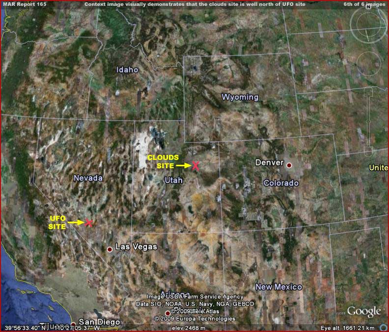
The above 6th and last image here
shows a comparison of the position of the UFO site at latitude 37º north
in Nevada and the three clouds site further northeast at latitude 39º
north in Utah. This visually demonstrates that the Utah cloud shadow evidence
should most definitely be from a southern sun but obviously isn't despite
the difference in latitude being even further north than the Nevada UFO site.
Trust and truth are too often tricky issues and not good companions in programs
like Google Earth. Such programs can be useful but only if you are taking
everything in from it with grain of salt. A small measure of truth usually
only comes when the target area and who ever owns or occupies it: (1) has
no vested interest in what is revealed (example: a corn field); or (2) when
someone thinks that we out here in the populations are too ignorant and/or
dumb to figure the evidence out for what it really is; or (3) when mistakes
in visual obfuscation tactics are made allowing a little truth to slip through.
In the case of the UFO site, a suspicious person might begin to think that
the whole scene has been manipulated and staged and is a visual trap for the
unwary viewer cruising the imaging of the Area 51 locale. Remember that Area
51 is the most famous well known unknown black operations site in the world
and so a great many are going to be scrutinizing the site area. Knowing this,
there is no way that military and/or black operations intelligence would have
allowed this UFO visual in this area to be seen, regardless of who the craft
may belong to, and it not be at the very least manipulated by them. It only
becomes a question of what kind of obfuscation and manipulation it will be.
Since there are no details of the UFO craft to be seen (that is also likely
intentional), I suspect they allowed it to stay knowing it would eventually
be found in Google Earth. The shadow issue manipulation is there to provide
plausible deniability and an escape hatch should the going get too hot over
evidence like this in the public's mind. They can always just stonewall and
claim the evidence is just ground effects. The single lone cloud was placed
there along with its too dense artificial shadow to act as insurance that
the ground effects conclusion will ultimately be the deciding factor for those
with a greater trust level and that includes most of the bulk of the population.
Meanwhile, the evidence otherwise serves to titillate and increases interest
without really revealing anything. In the shorter run, it is bait leading
to a desired psychology and end. That end might be to eventually condescendingly
discrediting researchers like myself if or when needed should too many in
the population begin to take the evidence seriously. Even if it is actually
an alien craft and not one of our own, it may still serve misdirection purposes.
For example, it can act as a red herring warning for foreign powers giving
them pause as they look at this and consider believing that Area 51 produces
such superior advanced craft and propulsion systems and so you had better
watch out.
Can't believe someone would be that slippery? In fact, such misdirection tactics
are old ones used by governments. For example, in WWII the Allies developed
a whole massed army of false equipment and personnel dummies in English fields.
They were meant to be seen from the air by German pilots trying to convince
the German high command via that observational feedback that the coming invasion
force was stuck there while the real force was approaching at Normandy. Likewise
Saddam Hussein in Iraq held enemies at bay with a relatively empty threat
of weapons of mass destruction and the perceived willingness to use them.
This is why I don't like to do this type of reporting on this constant diet
of secrecy and manipulation. It may be true that we in populations need to
understand it better and some of you may even like it but I know I could do
without it after having seen so much of this kind of thing in the science
data. In reporting it requires me to dive deeper into the twisted psychology
of the secrecy types and the reporting is long, intricate, and convoluted
because the subject matter is intricate and convoluted. It may be necessary
at times to raise public awareness but for me it is a distraction from more
important issues.
If you found this type of supplemental reporting tedious and boring, I am
sorry for that. However, it had to be done in order to counter to some extent
their trying to spring this baited trap on this work in the future ahead.
The only viable alternative would have been not to report on the UFO evidence
at all to avoid the trap. However, that too would have served their purpose
just as well.
I knowingly took the bait and reported because I believe that there is some
important truth here with this low flying object casting a true shadow on
the ground. On the other hand, I don't have to completely let them have their
way in springing the trap in the future as they implement their built in countermeasure.
, Investigator
![]()