
MARS PIT & FOREST
Report #212
December 9, 2012
Enter coordinates 5 32 13.29 S, 118 36 37.12
W in Google Mars
to achieve this context view
http://hirise.lpl.arizona.edu/PSP_004847_1745
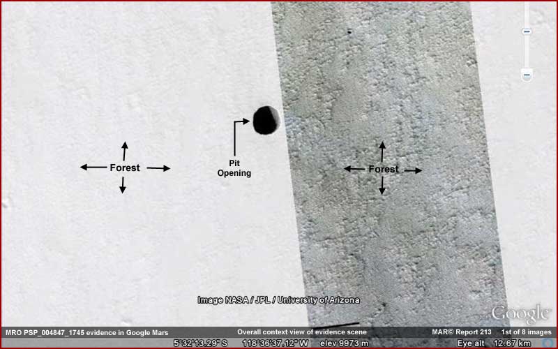
The above 1st black and white image provides
a wide-angle context view of this evidence site as presented in Google Mars
at the coordinates given above. Note that this evidence scene is supposed
to be drawn from the MRO image PSP_004847_1745
HiRISE image at the above University of Arizona link. If you go to the official
link, you will see that all the text there is about a dark opening to a huge
pit and nothing else but this report will reveal more of interest there than
just this pit.
Also of significance and as you can see in the above image, there is very
bright light color field that the pit evidence is within on the left compared
to a darker field on the right separated by a sharp straight vertical boundary
line. Note that the light color field has very little terrain detail within
it as officially presented while the darker field on the right has more detail.
This washed out effect in the light color left field is likely in theory intentional
as the portion with the dark pit in it was lightened excessively to try and
penetrate deeper into the pit's dark depths as much as possible.
Still, note that this considerable lightening process also has the effect
of obscuring any and just about all detail around the pit. Note also that
the darker area on the right certainly doesn't look much like forest evidence
in this official view and yet that is just what it is. Take note of these
factors in the official view as they will be significant in this reporting
as to what is obscured and perhaps why.
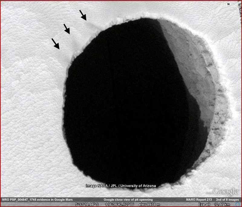
Enter coordinates 5 32 16.86 S, 118 36 42.72
W in Google Mars
to achieve the above closer view
As you can see in the above 2nd black
and white image Google Mars view, the pit indicates that the sun angle appears
to be coming from the lower left to the upper right and it appears to be illuminating
the upper portion of the right interior pit wall with all the rest to the
left of that apparently in very dark impenetrable shadow. No doubt anticipating
that some will try to lighten the interior of the pit even more and fail,
this failure to penetrate the shadow is what the discussion text at the official
website page for this image at the University of Arizona link is mostly all
about.
In other words, the official text psychologically focuses our attention only
on the pit as the only evidence of significance and then on the reason why
the interior shadow is so dark and impenetrable. They admit that the latter
issue is strange but explain it away as an assumption that the interior of
the pit is so deep and that the side walls are tapering back away from the
pit opening.
However, you should also know that the above 2nd image is from Google Mars
and this view orientation is different than that in the official MRO image
that it has supposedly been drawn from. In fact, the view is flipped both
vertically and horizontally. The natural assumption is that the Google view
is the one that did the flipping but that is not a safe assumption at all.
I've seen a number of instances where the Google images refer back to officially
released images that do not entirely agree in orientation and that seems to
be the case with this imaging as you will begin to see moving further down
in this report.
By the way, the set of three arrows seen in the above 2nd image and in more
images below are just for reference to demonstrate this flipping process.
The arrows set points out unique terrain reference features at the edge of
the hole that demonstrate this flipping.
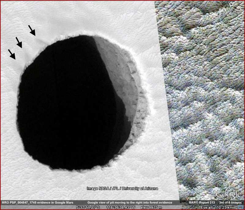
Enter coordinates 5 32 17.01 S, 118 36 28.43
W in Google Mars
to achieve the above view
The above 3rd black and white image again
from Google Mars provides a slightly more drawn back more distant but still
closer view relative to the 2nd image that encompasses more terrain detail
around the pit. Fortunately for us, the lightened portion with the pit in
it has the location of the pit close to the darker boundary area providing
some evidence from the adjacent darker portion to the right of the pit.
That view of the evidence to the right but still very near the pit demonstrates
what very suspiciously does not look at all like
rock and soil geology but suggests densely packed forest evidence of some
kind completely covering the true terrain geology. It most definitely is at
least something that we need to examine closer in the images below.
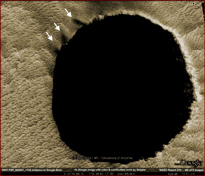
Enter coordinates 5 32 16.86 S, 118 36 42.72
W in Google Mars
to achieve this closer view less color
The above 4th image is just the 2nd Google Mars image in this report with some clarification work in it by me and adding a little false color to please the eye. Part of that process included darkening the image to counter the washed out lightening originally put on it. Note that in the process the darkening caused the obscuring of the right interior wall evidence.
JP2 Quick look Download Grayscale non-map 471.5 MB
http://hirise.lpl.arizona.edu/PSP_004847_1745
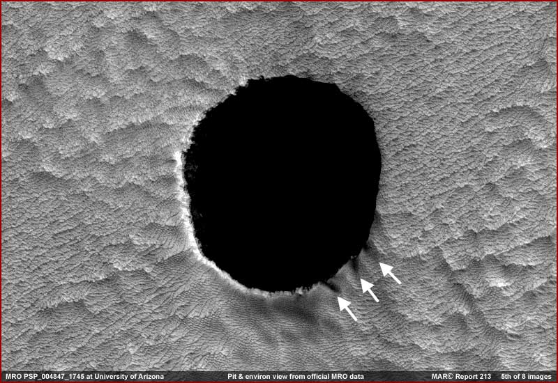
Now the above 5th black and white image is taken by me from the original MRO PSP_004847_1745 JP2 471.5 MB image rather than the Google Mars imaging. It is in its original form with no work in it by me except to install the 3 reference arrows set. Note that here the sun angle is from the upper right to the lower left illuminating the lower left interior wall of the pit quite different than the Google Mars imaging. Note also how different the terrain around the pit looks in this official view. In fact it appears inverted with everything pointed up in the other views now pointing downwards in this what is suppose to be original imaging view.
JP2 Quick look Download Grayscale non-map 471.5 MB
http://hirise.lpl.arizona.edu/PSP_004847_1745
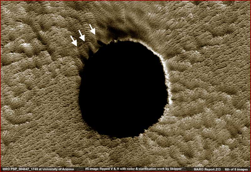
Now the above 6th image is simply the
5th MRO PSP_004847_1745 black and white image view flipped both vertically
and horizontally by me to agree with the Google Mars imaging orientation and
also with some clarification and color work in it by me. Note the position
of the arrows confirming the flipping. Also note how dramatically the terrain
around the pit has changed. So which came first, the chicken or the egg here?
This concept is significant.
Why? Because the official MRO view in the 5th image is not stable. Depending
on one's psychology, most often the view in the 5th image looks inverted downward
and via that looks a little more like raw geology as compared to the above
6th image view that always appears just as it does above strongly suggesting
biological forest life. However, again depending on one's psychology, the
human eye and brain often detects the 5th image instability and keeps wanting
to correct it by doing the flipping itself. So the view in the 5th image can
for some fluctuate back and forth between the inverted look and the raised
look. So, if this happens to you, no you're not going crazy. Your brain is
just trying to make sense of the 5th official image view because it knows
that something is wrong with it.
The nearby presence of the more stable 6th image with its always looks the
same view providing comparison tends to help stabilize this 5th image effect
phenomena a bit but here's the real point. The observational unstable effect
in the MRO 5th image tends to bring into question
whether this MRO image itself is truly original or not and whether it has
been flipped vertically and horizontally somewhere at official level to produce
the invert effect to try and obscure what the terrain around the pit really
looks like. Remember, scientists will be looking primarily at the MRO image,
not the Google image. In my opinion, these factors suggest that Google has
mistakenly been supplied with a different source image without this bit of
manipulation in it.
I also must mention that no amount of lightening that I've done on this 5th
"original" MRO image, even to the maximum, will reveal any of that
interior wall portion that you see in the Google Mars 2nd and 3rd image above.
This again brings into question and suggests that the Google Mars image has
not been drawn from this particular MRO image, at least not the one that is
available to us here at the link above.
Logically, this in turn suggests that different manipulated versions of the
MRO Mars imaging are floating around out there behind the scenes with we in
the public getting only the crappiest of them all. Google on the other hand
with its own imaging facilities sitting on government provided covert facilities
and its enormous wealth is getting something closer to the real thing once
in while perhaps when a mistake is made at official level. Likely few in Google,
like most everyone else, may even know the difference.
Okay, so much for the hole in the ground, which I am now very suspicious of.
Lets move even more on to the terrain evidence around the hole. Below are
a couple more sample images of the "terrain." Note that these were
taken from the Google Mars material in the darker area. I found that, in this
particular case, it is actually of slightly better visual quality that the
enormous JP2 471.5 MB MRO image files when trying to take a closer look at
the evidence. Of course that should be impossible but it is what it is and
again suggestive of the MRO images being the manipulated ones.
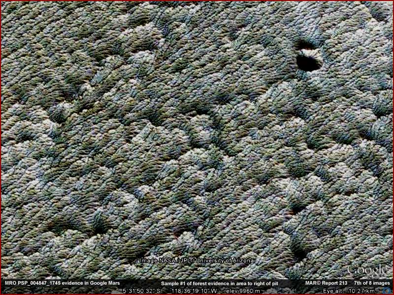
Enter coordinates 5 31 50.32 S, 118 36 19.10
W in Google Mars
to achieve the above view
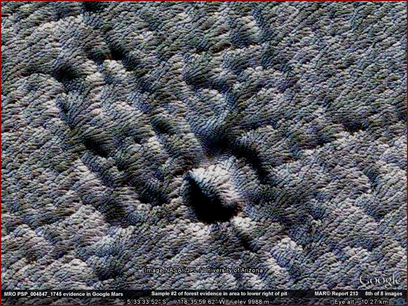
Enter coordinates 5 33 33.52 S, 118 35 59.62
W in Google Mars
to achieve the above view
The above 7th and 8th images are just
representative samples taken from Google Mars in the darker field to the right
of the lightened wash out field around the pit. The 7th image is of more level
terrain and the 8th is of a bit rougher terrain demonstrating how the bio-life
evidence performs in each. The light color tints are not mine but that already
existing in the Google Mars material. The entire darker section is a solid
carpet of this evidence with very little variation from one location to another.
As you can see, this evidence is the same type of evidence revealed immediately
around the pit in the 4th and 6th images once the extreme lightening wash
out effect was countered, just a difference in Google Mars color here versus
my coloring. So what do you think? Is this "terrain"
geology or life?
A visual hallmark of natural geology is a lack of repetition. For example,
so many different forces are at work shaping the visuals of an object or objects
both from within and without and from one geological spot to the next. This
means that geology is most often characterized by fairly obvious visual differences
from location to location. However, a hallmark of healthy biological organic
adult life is the visual similarities that have been guided by and are conforming
to genetic coding and especially over very broad areas. Object differences
are there with bio-life but they are most often very subtle and must be learned
by repeated exposure and experience.
Human perception conditioning plays a role as well. For example, a geologist
might look at the above images and, partially influenced by this location
being near a volcanic area, say it is an ancient surface lava flow base eroded
by weather into patterns of similarity regardless of the reality, just strangely
over an unusually very wide area. On the other hand, a paleontologist might
look at the same thing and say biological life growth conforming to its genetic
coding resulting in consistently appearance wise repeating its self as it
covers and hides the underlying geology below. I suspect it will come as no
surprise that in this case I subscribe to the latter observation.
My opinion, and it is just that, is not only formed by the visuals here but
also by the verifying presence of other similar bio-life on Mars presented
previously at the website but especially the best of it in my book that has
densely packed old adult growth covering and hiding the underlying geology
completely in massive areas and otherwise behaves in this same manner. The
densely packed bio-life evidence here is not much different except in looks
and likely it is a different species adapted to the higher and likely dryer
elevations formed in volcanic regions. In other words, while this kind of
thing may be new to the Mars inexperienced, it is nothing new to me at all.
In fact, although it doesn't look exactly the same, the forest evidence here
reminds me of algae growth evidence in my Report
#182 on Earth evidence as well as Report
#082 on Mars evidence, just with a bit closer view here and the evidence
here is of a larger size and therefore easier to see. However, the previously
reported on evidence at the website is most likely fully immersed in water
while the evidence here is not. In other words, it might just be some type
of algae growth adapted to surface open air non water emersion conditions.
Too bad the imaging doesn't catch the edge of this forest evidence field as
that would be much more informative. Further, that may be by intent. In all
of the many tens of thousands of images I've viewed, I've yet to see the imaging
catch the edge of this type of massive carpeting life evidence. It's always
like what you see here. It's like taking a straight down closer image of a
mid-section of household carpet in an empty room without the view including
any edges. Would you even know what you were looking at if that image wasn't
part of a context set of other images of a household that might act as a clue?
In any case, while the official position might like to focus our attention
only on the non issue of a hole in the ground and hopefully limit us to that,
in my opinion, the real evidence here is in the terrain around the pit under
all that washed out lightening and in the darker strip to the right and adjacent
to the pit. However, as always, you must make up your own mind on this. I
can only present the visual evidence and my opinion for your scrutiny and
judgment.
, Investigator
![]()