
DISSECTING A WATER FIND
PART #1
Report #024
August 27, 2001
In my report titled "Forests of Life on Mars" which can be found HERE, I referred to the image tampering technique of backing the camera resolution off of the target in order for the now distant view to cause a string of individual already small buildings to become even smaller and blur and merge together with the result that they now appear to be just a single string of low ridge line and part of the natural geology. To give you a bit better idea of what I am talking about, I'm releasing one of my water discoveries here that also includes this tampering technique among others so that you may get some idea where I'm coming from when I make such references and also bone up on some image tampering in general.
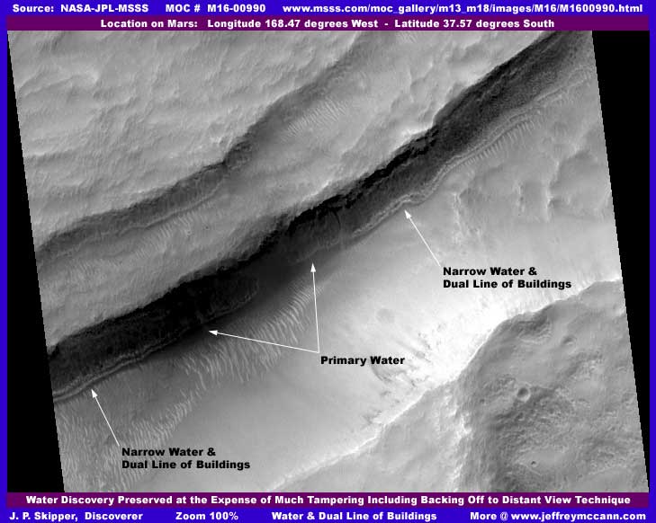
This above first image is just as it appears in the original at the original size and color with no manipulations of any kind by me except for the identifying text and arrows. The scene looks ordinary enough on the surface but the fact is that this image is loaded with image tampering and all of it is designed to keep the water visible while insuring that no tacky unwanted civilization evidence intrudes on the water discovery. In fact, except for the waterway itself, very little of the environs visible around this water is real but is created illusion. Unfortunately for them, the degree of tampering necessary to get rid of all the civilization evidence is so varied and heavy here that the water discovery itself is partially obscured, too distant, and not very obvious at all making it difficult to see and discover. That is not exactly what they where hoping to accomplish here.
First, lets start in the center of the image with the water itself and work downward. Note the primary water (as labeled) where the waterway widens out a bit. A shallow grade from the right and from the left where there are narrow ribbons of water results in water flowing into this slightly lower area creating a slight broadening in the waterway. The long dual parallel light colored low ridges in the narrow waterways extending out on each side of the primary water are in fact a dual line of buildings at the edge of and actually in the water creating a shoreline look. Remember what I have said a number of times elsewhere in these reports, those who live here do not just regard water as a basic utility and source of life as we often do, rather it is a part of their lifestyle and identity. They often do not just want to be near it, they frequently want to merge and interact with it.
Water overflows from this long waterway down a gradual slope in the long broad area below and parallel to the waterway located under my arrows and text. The key to understanding this is the ridge forms that you see under the waterway that are all oriented down the slope and in the direction of the flow of water. They are formed by an organism that lives in shallow water flowing down slopes. I have referred to this in other reports but the best single report on this subject titled "The "Tubes": Natural Geology or Life?" can be found HERE. At the bottom of this slope will be a larger collection of water and often bigger structures around it including processing plant size as this is often the largest and deepest collection of water in two level systems like this and the site of industrialization while the upper level controlled shallow water is more of a living environment with structures relating to that principle which may include residential, resorts, entertainment, commercial, and government.
Of course civilization evidence is a no no, so they have put broad sweep type tampering over all of the civilization evidence at the based of the ridge form covered slope and even most of the ridge form slope itself in order to break up any look of organization that might attract unwanted less gullible and credulous attention. If you believe that this smooth mostly featureless sweep tampering is real terrain, then I've got a bridge in London that I would like to sell you cheap. Basically, this sweep tampering covers a sloping canyon floor and hides everything under it.
Now the area immediately behind the dual parallel lines of buildings (oops, excuse me, I mean low ridges) appears to be a cliff system. The waterway is formed by water draining underground from this higher level back drop and collecting in the lower level purposefully shallow waterway before overflowing from it by design down the ridge form covered slope to the larger and deeper final even lower level water catch system at the bottom of the slope and canyon floor hidden here under the sweep tampering. The cliff looks real and there may even be a real cliff there but no detail of it is actually visible because all is covered under a combination dithered fog tampering treatment with a ink black treatments scattered throughout at the top to break up the dithering fog treatment and give the cliff top illusion some detail and sharpness. You may be able to see this better in other closer view images that follow here.
But, before we leave this first wide view context image, you should also be aware that all of the rest of the image area from the "cliff" top line up into the background has been subjected to a color blended fog treatment both in clumps and in thin layers as well as a more severe reduction in resolution treatment than the scene from the "cliff" down. The key to understanding this is to be able to see the second cliff wall and water system in that area behind the main cliff system. This was probably a poorer view to start with and they just decided to eliminate it from consideration all together by giving it this broad series of treatments to fuzz everything out so that the primary focus could be solely and safely on the primary larger water discovery below it. It also appears that the light colored low ridge line there is also very probably buildings but of course resolution is far too poor to be certain of this which is the whole point of what I'm trying to get you to see and understand about this successful tampering business and how it works.
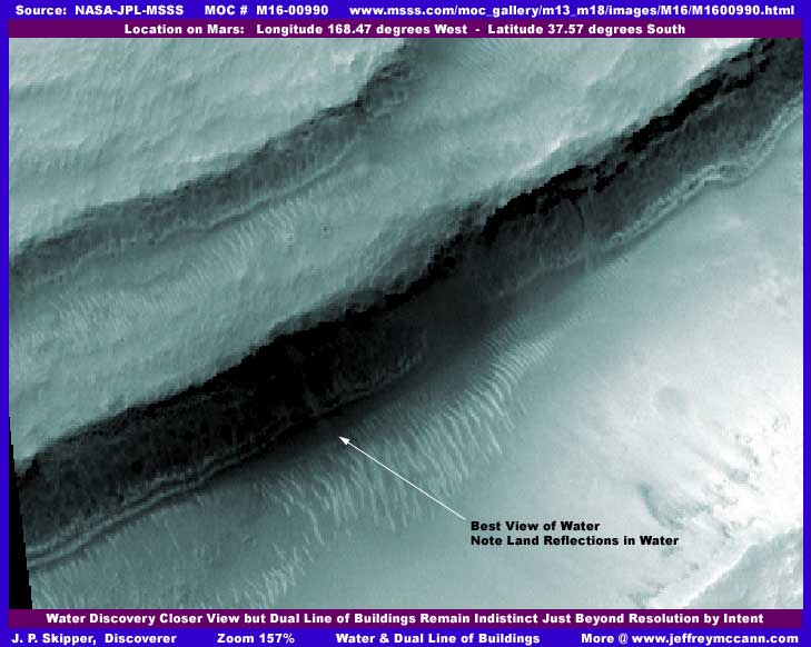
The second image above is a little closer than the first and I have added just a little color (but nothing else) which helps differentiate things just a slight bit better. Of course no buildings can actually be seen in the dual parallel low ridge lines but you can at least just begin to see that these lines are made up of a large number of individual vague objects rather than a long string of continuous land form or shoreline geology. Further, you can also just begin to see that the cliff wall is actually not visible at all, only a dithering fog and dark ink black treatment along the top to break up the continuous pattern of dithering fog treatment and give these specific areas the look of a cliff wall. The most likely scenario is that this treatment creating the look of a cliff wall is actually hiding larger buildings not adequately dealt with by the overall backing off to provide distance and reduction of resolution technique.
In talking about all this tampering going on here, we don't want to forget that this is a legitimate water discovery with all its life implications. Let me say that, although this water is legitimate, even it has been tampered with. First, there is a large area of thin semitransparent shadow application right over a portion of the primary water at the end of my arrow and extending to the right of it. You can see the faint shadow of this extending over the water and out over the ridge forms down the slope in a half moon shape. This was done to cover something at the right edge of this particular tampering where the tampering gets thicker and more covering at that point. But, the result was too much degrading of the view of the water, so they retouched up the primary water in the left field in the area I have pointed out with text and arrow as the "Best View of Water..."
This is admittedly difficult to see unless you have a lot of experience with these Mars images and these tampering techniques but a few of you may be able to see this a bit better in the even closer view images that follow. For those that can see and/or understand what is really going on here, it demonstrates just how important the eventual discovery of this water and I suppose vegetation (since some of it has also been left clear of the tampering) is to their future agenda for Mars. But, I'm sure the game plan was a for a time, place, and people of their choosing and not my reporting too soon in the here and now. They should have known that there is always some nut (their probable characterization, not of course mine) out here marching to a different tune.
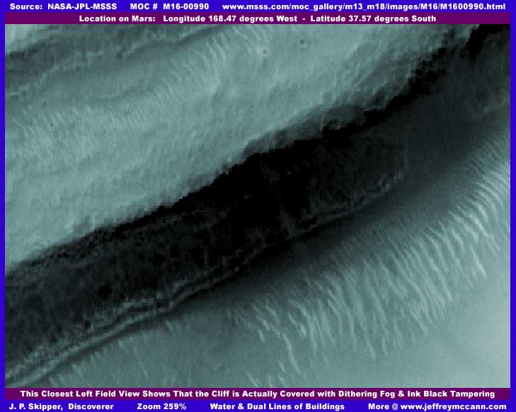
In the above third image with its closer view of the left field of the waterway, you can now began to see that the back line of the dual low "ridge" lines is beginning to look suspiciously more like possible buildings taking vague shape. Unfortunately, 259% zoom is about as far we can go before things just turn too fuzzy and there is going to be no definitive answer. Again, this is the point of the tampering as it is effective. The water can be seen a little better including even that light colored patch of ground on the land faintly reflecting in the water. Although the cliff area is really a bit too dark to see much in the way of details, especially in the center area where there is a lot of black lower down near the water, you can still see areas of the medium dark color dithering fog treatment to left of center and some of the ink black treatment along the top of this. This can be seen a bit better in the fourth image below of the right field of the waterway in some not quite so dark areas.
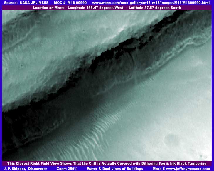
In the above fourth image of the right field of the waterway, the nature of the medium dark dithering fog treatment tampering can be seen better to the right of center on the "cliff" and the ink black treatment along the top. Many of you should at least be able to see that these areas are not true land or terrain detail but artificially created smudging with no true terrain detail or features at all. Same with the smooth almost featureless sweep tampering in the lower right quarter of the image covering part of the ridge forms down the slope that is no doubt suppose to mimic a ice sheet. The lack of any real surface features on the sweep tampering and the faint shadow of true land detail seen very vaguely through and under this application should be a big clue as to what is really going on here, even for those with little experience viewing land images. I could have shown this better by changing the lighting but that would have come at the expense of viewing this legitimate water discovery and I didn't want to do that as the water is, after all, the main thing for them and for us. Water means the opportunity for life!
If you can ever get to the point where you can see and understand this tampering, you should then be asking the obvious question as to why is it there. Someone did not do this on tens of thousands of images spending many hundreds of thousands and probably millions of tax payer dollars doing it for a lark. The massive undertaking and expense represented by all this image tampering work is taken very seriously by someone and represents one hell of a commitment and risk taking. You must ask yourself what could be so important and so earth shaking to hide? It certainly can't be water on Mars because they have gone to great lengths to try to leave as much of that as they could for discovery. You'll see this in some of my previous reports and when I release the much better water discoveries that I am holding back. It can't be natural biological life like vegetation because we are finding a few of those that have civilization hiding tampering in them that specifically avoided hiding very obvious vegetation itself evidence. What does that leave? I think you know the answer as well as I do. In fact, there can logically be only one answer and you know that to, if you will face it.
I say this. It is wrong to live in ignorance and taking on risk of the highest order to try to remain doing so in the face of the true realty surrounding us. Pretense is always only a temporary bulwark and never never never holds! Realty always intrudes in the end and often with disastrous results if one is not prepared to deal with it. The further we go trying to hang onto pretense about what is and is not on Mars and the avoidance of how it may already be effecting our lives here on Earth, the more we risk disastrous consequences. If we live in a universe where we are not alone and not top dog, then lets throw down the nonworking illusion and get on with beginning to deal with the reality so that we can join our neighbors and connect with our true destiny so that we can maybe eventually become a top dog for real. If we are only a big fish because we are in this little self imposed isolated pond, then let's learn and get ourselves out beyond this little pond so that we've can get some stretching and swimming room. Isolation has never once worked in all of human history, so are we going to hang onto a already proven failed tactic?
If you ever do turn the corner and embrace acceptance of this reality, it is easy to blame others who we consider were supposed to be looking out for us and escape into the blindness of reaction but, subject to some individual exceptions, we as a population and people have participated directly in this big time by abdicating responsibility to others and not participating in what others are suppose to be doing on our behalf. Wow us with technical advancements and accomplishments but don't bother us with details as we just want to float along and not think disturbing thoughts. Now others who have carried this heavy burden for us for so long have been bent under the weight of it and with their nose stuck in the reality all the time while we float, they have come to distrust us and our reactionism to the point that decades of secrets have been kept from us for fear that the sleeper will awaken with disastrous results.
The first step in dealing with this is to first deal with ourselves. Instead of reacting emotionally and letting blame fly, we need to concentrate on being calm and rational and determinedly move toward constructive solutions while encouraging those running the show that have strayed into secrecy, elitism, and dictatorial paths to recognize that we can be responsible and join us in developing rational solutions and adjustments to the world that we really live in - or else. If we can change, they can change. If we can not or will not change, well I suspect you know the answer to that one.
DOCUMENTATION
http://www.msss.com/moc_gallery/m13_m18/images/M16/M1600990.html: This report's image evidence data here is drawn from NASA/JPL/MSSS's official MOC M16-00990 original strip. I used the second listed best quality map-projected gif strip but the faster loading first listed medium quality map-projected jpeg strip works fine and will be fine for anyone wishing to check behind me. However, note that the third listed jpeg and fourth listed gif not map-projected strips are flipped both horizontally and vertically which can create distortion. If you want to use these, you will need the necessary graphics software to flip them back to the correct orientation. I have not accessed this data at any other location such as PDS or USGS and can not comment on it there. Good luck.
, Investigator
![]()