
DISSECTING A WATER FIND
PART #2
Report #025
September 1, 2001
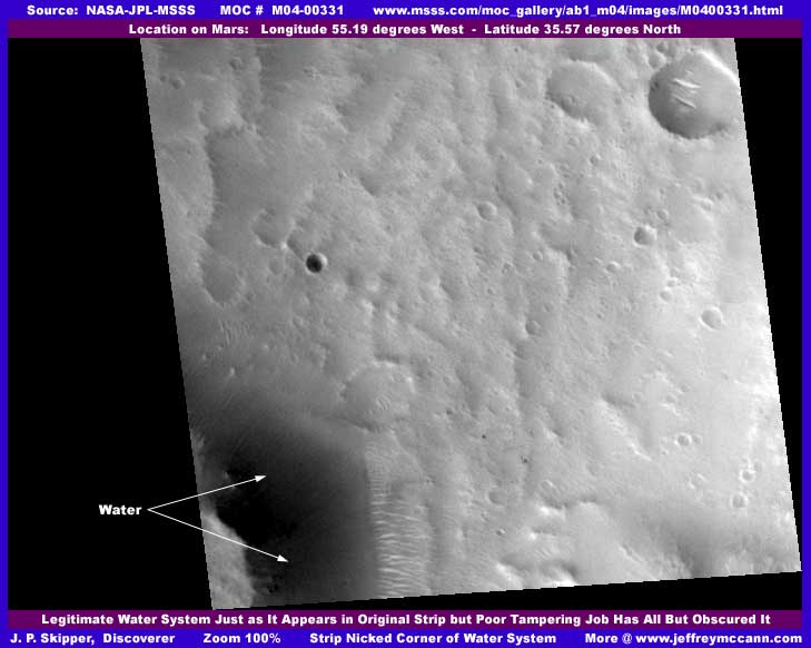
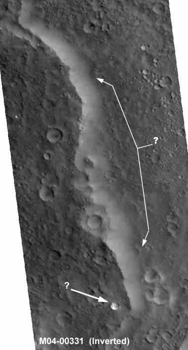
This above is a water discovery where the lower left corner of the original M04-00331 strip just nicked the outside of a small bend or finger in a much longer and larger water system. The image you see above is just exactly as you see the original with no adjustments on my part except for the addition of arrows and text. Notice how the water shading changes from darker on the inside (deeper) of the curve to lighter on the outside (more shallow) of the curve. Note the lands forms under the water surface. Looks pretty good doesn't it.
The only trouble is that, although I am satisfied that there really is water here, we can't actually see the real thing because of the illusion tampering overlaid all over everything in sight including the water and all the nearby terrain around the water. The only thing seen that might be the real thing is a partial view of some ridge forms on the right outside edge of the water system representing a water drain land slope there. That's it! Take a look at the next image below of a closer view of this scene but inverted and you may be able to see the tampering a little better.
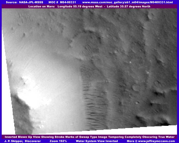
In the above inverted closer view, it can be seen that the water is actually covered by sweep type tampering with the stroke marks clearly showing in it. The smaller brightest white area at the inside curve of the bend is actually a ink black dark application seen in the original top image to cover whatever it is they wanted to hide at that point. The combination of dark application and then the lighter medium color sweep tampering over it is what gave the "water" its appearance of depth shading illusion and this is entirely intentional. This "recreation" tampering application work was necessary to reestablish the viewability of the water to continue to appear reasonably as water after the application of the dark black tampering.
To bad I didn't have enough image room here in this report to show you some closer views at normal coloration so that you could see this better. Still, the recreation of this water discovery scene by the tampering at official level clearly demonstrates that who ever is doing this has a agenda that includes future discovery of water sites like this and just how important this is to their agenda which is one of the points that I am trying to get across to you here and get you to factor into your thinking. Civilization evidence is a no no but water is not only acceptable but intentionally promoted, at least for future discovery even if they were hoping that mediocre quality recreation work like this would pass undetected.
In the above inverted view, the fact that the ridge forms are here does indicate the presence of shallow flowing water down a slope as explained in a previous report HERE about ridge forms and their function. This gives credence that there is really water under this water recreation "illusion" tampering. However, the neighboring outer terrain and even the land mass right in the lower left corner on the inside curve of the waterway shows signs of heavy and complete dithering fog treatment tampering covering all. A very close look reveals that this is a artificial application and not sand or dust over time filling the nooks and crannies as might first be assumed. The tampering hugs the basic contours of the uneven neighboring terrain giving it a lumpy quality and also intentionally forms pits, all to break up the blankness of the application and give it some detail it would not otherwise have.
As I've brought to your attention in previous reports, the automated software also circles around craters or round crater appearing objects intentionally leaving an occasional one of these to break up the blankness of the application and give it some detail so that it will not draw attention to itself. You can always identify this tampering technique though because the software leaves the crater rim and interior (unless it sees something it doesn't like in the crater interior) alone but nothing is visible of the crater's exterior outer slope as that has disappeared in the dithering fog treatment. Unfortunately, crater interiors often have water or ice in them and offer a protected environment from storms and both factors attract civilization. So, craters often disappear under the tampering blanket and/or received a big blob of smudge fog tampering inside them.
The more the illusion of terrain detail, the more the appearance is accepted as authentic and that is a goal of the tampering. But Mars is a planet with a thin atmosphere that does not serve nearly as much as a deflector and absorption shield as does Earth's very thick atmosphere. A small object hurtling in from outer space will usually never make it through our atmosphere to ground level. However, a small dense object can get through to Mar's ground surface. After thousands of years, the surface has really been peppered by large and small objects with the result that the surface logically has significant land surface detail. Add to that thousands of years of none to minimal vegetation to retard winds and protect the land surface under them, and you have a surface that is scoured by winds revealing high erosion rock details. So, when find yourself looking at this often seen soft smudgy billowy gentle lumpy ground detail as here in this image, it's time to be suspicious, look a lot closer, and assume nothing.
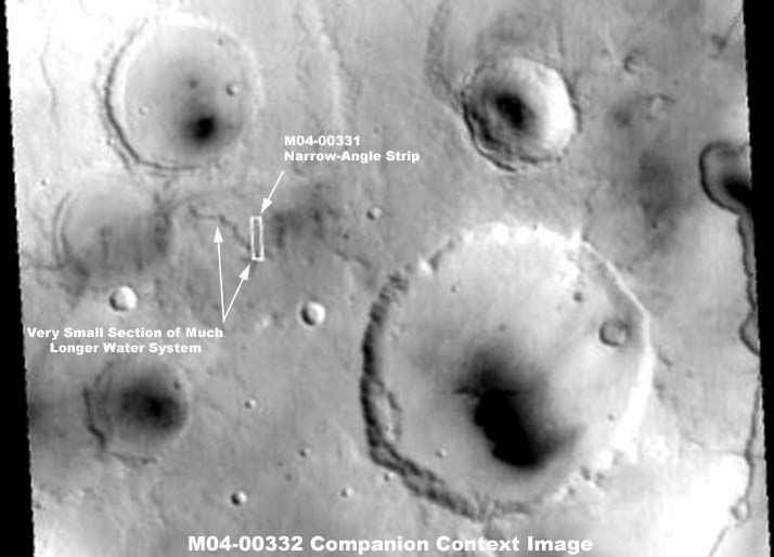
I've included the narrow-angle M04-00331's companion wide-angle M04-00332 context image strip above showing the location of the M04-00331 narrow-angle strip's location within it between these large craters. Notice how the bottom left corner just nicks the long winding trough system. I show you this to demonstrate that the piece of the water system caught in M04-00331 is very tiny relative to the whole size of this system. But, in the above context image, you might also note that there is a faint slightly darker colored tampering smudge application just to the immediate right of the M04-00331 strip outline and another larger area of this smudging to the left of it down in a crater giving it a fake shallow filled in look. What ever was there must have been really huge to warrant a tampering application to prevent us from seeing from this great distance.
But this recreated water system isn't quite all that is interesting in this image strip. There is a long trough system completely covered by sweep tampering in the upper part of this strip as well. There is no attempt to recreate the water here, just hide it because it was probably a small narrow system and not worth preserving it for view. Logically, there was still enough water there to warrant civilization evidence or they would not have gone to the trouble of hiding it. Also, there is a small impact crater at the lower end of it that turns out to be something else on closer examination. Note the two side-by-side A-B images below, one normal and the other inverted by me.
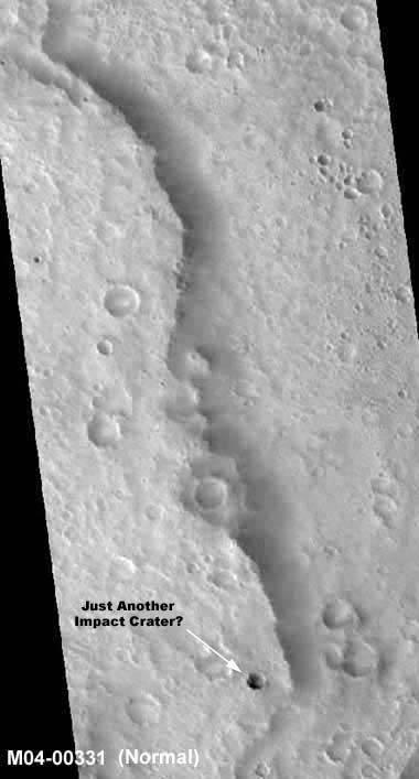
The two above A-B images demonstrates just what they have done to this long trough system. I suspect that the tampering was actually applied in the normal mode and then inverted to the uniform light color scene on the left. In other words, the true inverted mode is presented as fake normal mode. In the original, you do your dark smudge fog tampering all over the terrain including gradient shading the craters so that they appear humped outward similar to how you might create a 3D raised appearing button for a web site. You do your sweep type tampering over the trough system in a slightly lighter gradient shaded color. You then invert your work on the original and present your tampered with inverted image as the normal non-inverted one. The dark fog treatment becomes light mimicking a false daylight effect, the thoroughly fog covered humped craters now become recessed crater pockets appearing normal even if soft and safely featureless (a clue), and the sweep tampering now appears to just be a slightly gradient shaded darker fog or ice sheet with semi-translucent depth to it. The result is that the whole appears to be a old worn sediment filled in ecology. Yet, the truth is that nothing real of Mars is visible in the above two images except the small crater appearing object in the bottom area pointed out with arrows.
It's complicated isn't it. But, this is an example of just how devious and varied this illusion tampering can get. This is admittedly not easy to work out but I am still repeatedly amazed that scientists around the world can so gullibly accept this very obvious featureless rather crude sweep tampering as a true part of the true Mars landscape without questioning it. I suppose they don't because it is such a prevalent very often used technique seen throughout the MOC images. It is repeatedly seen many thousands of times always covering trough/canyon/valley systems as well as all the low ground around the edges of butts and mesas and hills in part or in whole. In other words, where ever water might be collecting flowing underground from higher to lower level ground. OOPS, that's another clue! Also they have been sold a bill of goods on the extreme temperature range and they may have assumed that these are ice sheets. Unfortunately, that is still just not adequate excuse for failing to detect this crude obvious fakery. Anyway, I don't want to get started on that.
Now let's get back to that little deep dark crater near the bottom of the trough system and image and pointed out with arrows in the above two side-by-side images. In the normal view on the left, it looks just like many other small craters, even if a little deeper and newer appearing than the others in the terrain around it since it does not have that old filled in whited out look. However, the "inverted" view here (really the true normal view) on the right is beginning to imply that maybe something else is going on here. The closer view below confirms this.
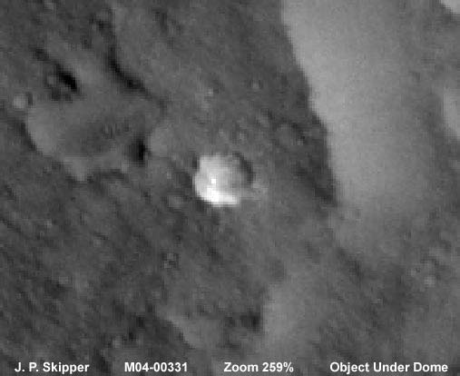
In the above blown-up view, it doesn't look much like a crater any more does it. In fact, it looks very much like a clear transparent round dome with sunlight gleaming off of the side of it and the whole of the dome filling with and picking up sun light. That is another very strong clue that this is the true normal view. There appears to be some large globular lumpy object in the dome casting a short shadow behind it. Unfortunately, this is as close at 259% as we can practically get, particularly with my limited imaging skills, and what is or is not inside the dome is just too vague and indistinct to identify at this limit of resolution. Still, thought you might be interested in seeing this miscellaneous lone piece of civilization evidence nearby the main water discovery that the tampering software managed to miss.
This is a flaw in the automated tampering software that I have reported on previously. It sees a round object and is also a bit confused by its transparent quality, so the dithering fog smudging treatment runs in a circle thick around the object's perimeter, in this case leaving it clear as if it was a crater top. On the other hand, if there had been obvious geometric angular shapes inside the dome like obvious rectangular buildings and windows, you can bet that the software would have covered the whole up in a heartbeat. If the buildings had been small and indistinct with already blurred geometric patterns, the software in its indecision may have just dribbled some smudging at random points over the surface leaving part covered and part visible and then moved on. As it is, the objects inside the dome are not readily recognizable to the software's programming and so the dome is default treated as a crater top and essentially left free like a tiny island in the midst of a sea of tampering.
No telling what was truly in the terrain around this dome before the tampering? Logically, from experience with these MOC images and the degree of tampering here, that would no doubt mean a large amount of civilization evidence of some kind. In fact, go back up to the M04-00332 context image and take another close look. See the faint smudged fog tampering to the immediate right of the narrow-angle M04-00331 image strip and right up against it. This would be the same locale as to the immediate right of both the upper trough system and the tampered with water find. It is via this kind of deductive reasoning of putting two and two together that you can partially get at what is really going on here and the presence of the isolated dome left out of the tampering reinforces the suspicions that the deductive reasoning brings out.
Don't let the tampering's lumpy terrain look around the dome fool you with its soft billowy crappy fake detail. The tip off is that true terrain would have many small hard line edges not apparent at all here in this soft blurred lumpy billowy smudging fog treatment. Further, from the amount of sunlight being picked up by the dome in its interior like the lens it essentially is, you can bet that the real terrain would have a lot of light reflections in it off of many different natural angles which is not visible at all here in this artificial application tampering field in either normal or inverted views. I call that a solid clue and one I want viewers to wake up to.
To fully understand what is or is not on Mars requires a understanding of the nature of the image tampering, just how extensive it really is, and what its purpose is. Everyone needs to factor the serious questioning of this into their thinking and reasoning. Our academic and scientific communities have so far demonstrated less than sufficient (to put it mildly) caution in dealing with the Mars data presented to them by their trusted leadership for decades and have gullibly swallowed this doled out scientific pabulum of a lot of truths, some half truths, a few key untruths, and a whole lot of misdirections hook line and sinker. In other words, you must think and act for yourself because, if you don't, your leadership does not have a clue and nothing will ever happen except what is planned for you by the agenda of an isolated few answerable to no one but themselves. Is this what you want? You must decide what is important to you.
DOCUMENTATION
http://www.msss.com/moc_gallery/ab1_m04/images/M0400331.html: My image evidence here was drawn from NASA/JPL/MSSS's official MOC M04-00331 original strip. I used the second listed best quality map-projected gif strip but the first listed medium quality map-projected faster loading jpeg strip works just fine to. However, the third listed not map-projected gif strip has been flipped both horizontally and vertically which can cause distortion. So, if you wish to use that one, you'll need the necessary graphics software to flip the strip back around to the correct orientation. I have not accessed this data at other sites such as PDS or USGS and can not comment of what may or may not be there. Good Luck!
, Investigator
![]()