
COLOSSAL WATERFALLS
TURNED SOLID
Report #050
May 6, 2003
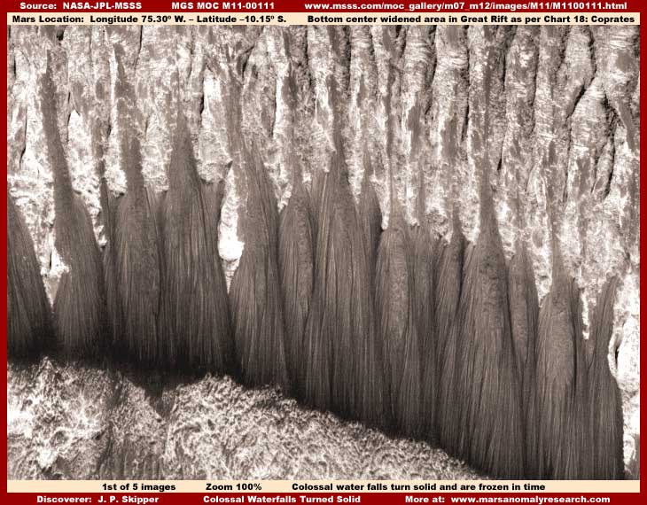
As you can see in the above first image from MGS MOC strip M11-00111, this will no doubt be regarded as some of the most striking looking evidence to come from Mars. It is strange and fantastic looking but the real question is, what is it evidence of?
The reason these images also look a bit washed out in the surrounding terrain areas is because these anomalies get darker going down around their base and I have the whole scene lightened to try and maximize viewing detail of these ropey forms all the way down to their bottom areas. Also, for the record, note that I've rotated the scene in my #1, #2 and #4 images here about 90º from the original strip side view orientation to this more familiar and more pleasing upright orientation. I have identified these anomalies as "Waterfall Forms" simply because that is not only what they sort of look like, it is also what they are to a certain extent. Let me also say up front that I can be positive about interpreting some aspects of this evidence but not quite so positive about other aspects as will become clear.
You should be aware that the scenes here are very distant and so the resolution in the rest of the light color normal size terrain here is extremely poor, so don't expect being able to see or identify much of anything even of relatively large size in the rest of the terrain around the anomalies. The human tendency is to interpret these huge anomaly objects as smaller than they really are in absolute terms. Just try to keep reminding yourself that this is an illusion and remember that these objects are actually massive in scale to the point of being absolutely colossal. A normal size large building would not even be a visible speck at the base of these things. That's why these objects overpower the poor resolution in this strip via their sheer size and they seem to be seen in reasonably adequate detail. It is in this manner with such unfamiliar colossal shapes as the only objects for comparison frames of reference that the rest of the terrain is so easily and effectively obscured.
You should also be aware that the upper part of my image here represents a great height in the land and the terrain the darker anomalies overlay in the mid areas of the image is a fairly steep downward grade. With that understood, note the many parallel gullies in the terrain in the top area of my image and how their vertical orientation downhill is the same as the dark anomaly's ropey strands. Actually these "gullies" in the upper terrain are more the size of large valleys, just smaller looking here because they are so very distantly seen. Regardless of whether they are termed gullies, valleys, canyons, etc., the most important thing to understand is that they are carved and formed by liquid surface water flow following gravity forces from these heights down to the lowlands further below and that is more the main reason I'm showing you this evidence here, not just for their striking looks.
Even in these heights, I suspect that the light color higher albedo terrain in the upper part of my image with its many water erosion valleys may be the remnants of an old ancient ice mass that has resisted periodic melt conditions over the ages because it is heavily permeated with sediment and is now as much rock as water ice. The moisture in these heights may also be replenished to some extent by rising and cooling air dropping its moisture content out as snow in these colder heights creating a upper layer of water ice more sensitive to subsequent temperature changes and melt conditions than the sediment heavy water ice base under it. As periodic warming conditions and/or solar radiation contact create many shallow water melt flow areas off the sides of each valley's slopes, the water joins in the bottom of the valley canyons and gradually cuts through the harder base terrain on its way down to lower levels.
As this process progresses, the water with its sediment load comes to the point of a increasingly steeper grade where the heights start dropping in a increasingly sharper degree of pitch down into the lowlands below and the flows increase in speed, but not enough speed or water flow volume to pitch them out in the air as would be the case with a true vertical free drop waterfall. Here water flows more gently along on top of terrain surface initially and then later on top of the hard surfaces it has created. As water goes down this increasingly steeper slope, heavier than water sediment and mineral compounds are released along and along to settled in the bottom of the flow adhering to the hard surface the fluid part is flowing over. When such conditions persist over long periods of time, the water flow path is increasingly built up by the sediment deposits forming a vertical hard form such as the many ropey strands you see here.
This is very similar to the creation of stalactites in a cave system formed via dripping water carrying mineral compounds that precipitate out forming a vertical rock column form hanging from the ceiling. However, where water flows entirely vertically down the cave's vertical stalactite, in a site such as the one depicted here the water flows down a fairly steep grade but one that changes pitch angle from a more gentle slope to a steeper one. In this situation, the hard surface the water creates and flows over grows and changes in relation to the sediment and minerals that adhere to it. This in turn eventually forms a partial blocking dam as well as changes the slope and its angle. These factors then change the water flow path.
When this progresses to the point of building up sufficient solid form height to inhibit water continuing to flow adequately along the original path any longer, the flow seeks a new and easier path by moving over to the side of the growing obstruction. In this new path the flow then begins creating another build up of sediment into another ropey strand that eventually grows large enough to change the flow direction again. The degree of water flow volume probably also fluctuates in response to changing temperature and environmental conditions creating new flow paths. This process continues and repeats itself many times over time.
Each new path is created more to the side of the original path. Over a very long period of time, the ropey strands you see here create this form's physical appearance where the many strands fan out from the original path and then follow gravity downward. The primary thing you need to understand is that the darker anomalous forms you see here are formed by a building up concretion process as heavier than water compounds precipitate out of flowing liquid surface water and that this is an ongoing process that continues to the current time rather than something relegated to the distant past.
Likewise, ancient or current, these forms are NOT formed by paths being eroded out of already existing geological bed material creating gullies and ridges in that material and thus forming these shapes. When you examine thousands of Mars satellite imaging strips, you become very familiar with the natural erosion of slopes and this evidence, at least down on the waterfall forms themselves, is certainly not that. Likewise dry dust or loose sediment particulate sliding from heights to lower level terrain tends to spread and level out forming a broadened base at the bottom of the slide path. Such slides most definitely do not create these hardened more vertical forms that do not seem to get thicker at the base or pile up in the lowlands and certainly doesn't develop this many ropey strands appearance.
Even though there are a few strips with this evidence in them, you should also know that these anomalous formations just as you see them here in these colossal sizes are not plentiful on Mars but are a bit rare. Assuming a purely natural geological cause, they are the result of many temperature, water, and terrain slope factors coming together in the just the right combination to encourage their development.
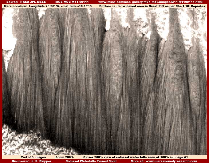
In the above 200% closer view of the same anomalous objects seen in my above first image, you can see that the individual ropey forms better that constitute each mass actually tends to give out some as it reaches the lower level terrain, or at least grows no larger. Near the bottom and over the distance of this great height, any given water volume gradually looses more of its sediment load in the upper areas so that it has less to deposit out in the lower areas. The water that reaches the bottom is simply absorbed into the terrain or evaporated off from a catch system we can't see within or under the base. Further, this process can be assisted by daily thawing and refreezing of the water in the downward flow process over long periods of time prolonging contact time and therefore assisting build up.
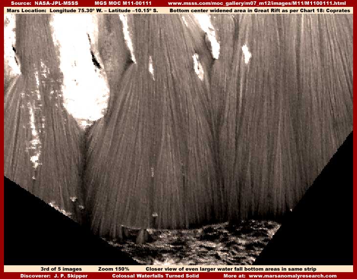
Now here again in the above third image you see the base area of an even larger series of these anomalous forms drawn from a different location nearby in the same bluff system. To me this is the most striking and compelling information. This area is located right at the bottom corner of this same strip. This particular scene is rotated 50º to achieve this more familiar and normal upright orientation view. Note how each individual ropey strand line in these masses remains clearly intact right to the bottom and does not tend to thicken more near the bottom than at other points in its length. Neither do they pile up and spread into the lower level terrain to any degree at all. If there is a purely natural explanation for their existence, this kind of visual evidence obviously tends to support the stalactite type of formation concept and dash any would be arguments that this might be the result of natural geological erosion or sediment slide effect.
However, in this above third image, it must also be noted here how evenly each individual ropey strand tends to terminate in this terrain at its base and in a rounded organized pattern. Most curious! Note how circular the center left mass and each of its ropey extensions seems to follow fairly perfectly a partial circular outline in meeting the terrain. In fact, this is so even and so suggestive of organization that it brings up the question of whether this evidence may be influenced by forces other than natural geology?
For example, could this actually represent a natural process but flowing over and covering and disguising a massive rounded artificial structure providing some kind of hollow civilization space within the ropey stranded mass? Could that partial circular outline be caused by a artificial retaining wall, a wall that the bottom of the ropey strands so clearly seem to disappear behind? If a wall, could it be providing a water catch system we can't see within the mass interior area and preventing excess fluid over flowing into the foreground terrain? Could there be someone living in a intentionally created massive art form here and cultivating and/or manipulating this design out of natural processes?
This is of course speculation but there is just enough tantalizing evidence here to encourage this. As you can perhaps tell, I am very suspicious of this and do not believe that this kind of suggestive evidence can just be ignored. Now if we just had images with resolution good enough to give us a better look into that surrounding terrain where I suspect there are some answers. Even so, if you will get very close to your computer screen and examine very closely the little patch of foreground terrain in the above third image, you might be able to see that this terrain seems to be tending to resolve into tiny crowded rectangular structures, some even with rectangular openings. Unfortunately, this evidence is just too tiny and therefore too ambiguous but still very interesting in its implications. Perhaps time and research will provide more and better answers.
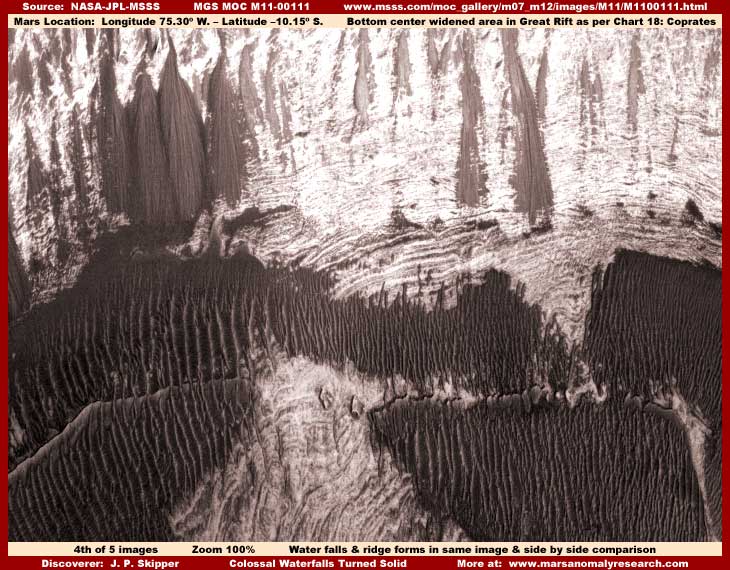
Now for the above fourth image from a different but nearby location in the same strip. Here again the scene is rotated 90º to the more familiar upright position. I've included this scene because it demonstrates the presence of both the waterfall water weep ropey strand forms along the slope in the upper areas of the image as well as the presence of dark tinted Ridge Forms in the mid and lower levels. Note that all this evidence is oriented in the same vertical direction and all of this scene represents a slope down from the top areas to the bottom down which shallow liquid surface water flows.
I don't want to get into long discussions of this complex subject here, so I'll refer to my very first report titled "The Real Smoking Gun as to Life on Mars" found HERE and my follow up Report #18 titled "The Tubes: Natural Geology or Life?" found HERE that cover quite a bit of the "Ridge Forms" subject matter. The bottom line is that, whether light or dark in color, the ridge forms represent the presence of shallow water following down a slope and they are created by and represent life of some kind capitalizing on that water. When seen on water trough system slopes that are long but relatively short down their slope grades, they appear in distant poor resolution satellite imaging as long narrow continuous forms that have been mistaken for and reported on as segmented tubes and even worms. However, when seen on water system slopes that cover broader areas, then they appear as broad patches just as you see here.
Their value to us here is that their presence confirms, along with the waterfall ropey stranded forms, the presence of shallow water flowing down a slope in the direction that the ridges and strands are oriented in. Although the waterfall forms seen in the upper left of this third image scene are a bit smaller than the largest depicted here in images #1, #2, and #3, they are still very large in absolute terms and do demonstrate a reasonable and valuable size comparison between the two different types of these water associated forms. More specifically, even though my early reports on the "Ridge Forms" did not stress this enough, this comparison confirms that the ridge forms as objects are actually much larger than they seem to appear when seen alone in this satellite imaging.
Further, although the evidence is too small and therefore too ambiguous to waste an image on here (with the last & 5th image, I'm all done space wise), a very close examination (difficult due to the very poor resolution) of these ridge forms at maximum zoom levels indicates that the ridge tops tend to resolve into multiple tall rectangular structures of differing heights in a line that does not follow the pixel grid and the space between the ridges is filled with darker and smaller rectangular structures. Again, evidence too tiny and ambiguous to be conclusive but still very suggestive of possible civilization.
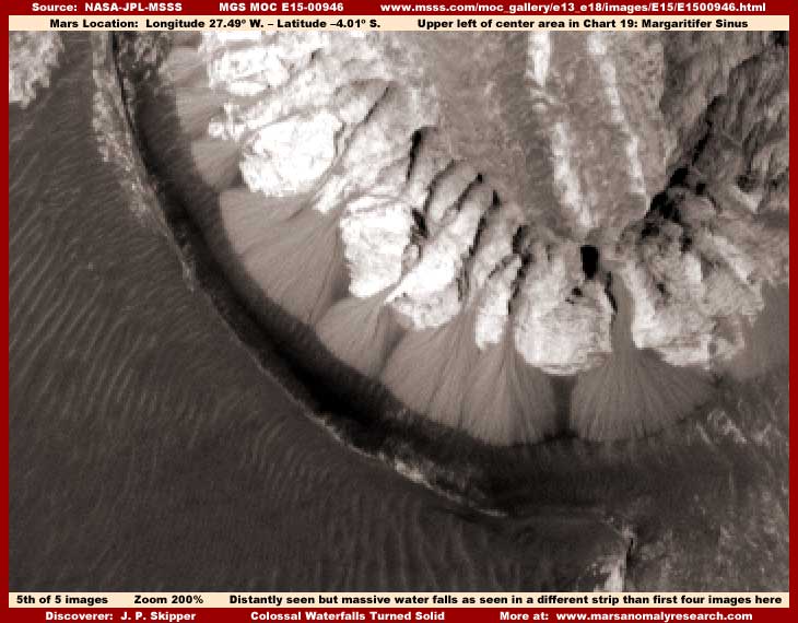
Now, just so you will understand that the M11-00111 strip evidence is not some kind of strange lone aberration representative of little on Mars, my above fifth image as drawn from the different MOC E15-00946 strip in a completely different locale demonstrates another example of these ropey stranded waterfall forms. Note that this scene is even more distant in resolution and it took a 200% zoom factor to give even this very distant look at this evidence. The sharp demarcation line you see between light and dark on the forms near their base area appears at first to be probable shadow cast from a rim ridge line that partially surrounds in an arch the waterfall forms to our left of them. Because of this, their bottom base areas are hidden in this dark area.
One aspect of the evidence that can really be seen better here, even at this much greater distancing over the previous strip, is water erosion channels cut out of the terrain above the waterfall forms which clearly feeds them. In fact, the very broadest of the erosion channels feeding the largest right most waterfall form is especially self evident and is one of the main reasons I chose this particular strip so that there can be no question as to this feed process. Here again I suspect that the light color higher albedo terrain immediately above the waterfall forms that is clearly having channels cut in it by liquid flows may be old sediment heavy dirty appearing water ice rather than true rock or earth alone.
However, you should also take special note of the presence of the dark ridge forms occupying most of the lower left quadrant of the terrain of this image. This ridge form evidence again confirms the presence of shallow water flowing down this broad area and that water is present in this terrain whether we can directly see it or not. Note how the ridge forms go right up to the edge of the rim that is turn suppose to be casting a shadow on the waterfall form's base areas. The presence of the ridge forms right up to this point indicates that water is probably spilling over this rim from the trough depression system at the base of the waterfall forms and traveling down the slope the ridge forms occupy. That implies that this rim may not actually be high enough to cast a shadow on the waterfall forms bases and may in fact be dark tinted liquid in a trough catch system at the base of the waterfall forms.
If only natural geological forces are at work here, both the very large size of the waterfall forms and how widely fanned out they are from their center area and the large mature size of the ridge forms indicate that they could only have been created over a long period of time. That indicates that these two different water based systems are old, long established, and stable. That in turn means that this is a long well established water based ecology that life could capitalize on. As I've stated before, the ridge forms do represent a form of life of some kind, of that I am certain, and they are clearly capitalizing on the water resource.
However, other less massive life could be in this very distant scene without any evidence of it being shown in this very distant imaging. In fact, I am suspicious that the waterfall forms also represent a smaller organism in the water form of life as well. The question is what kind of life? This is where we get into the inadequacy of the evidence due to poor image resolution and such tiny sizing that in turn equates to inadequacy of any conclusions in this regard. In other words, I can't really answer this will any real level of confidence other than what I've already described.
For example, when viewed from the great distance resolutions provided in this science data, the ridges look like ridges. I am well satisfied that they always come to exist within a shallow water flow system down a slope. I see tiny scale evidence of this over and over again. They also build up higher and a bit wider the older and more successful they are but always parallel to the water flow direction and never develop to impede that flow. In fact, I suspect the trough depressions between the ridges are by intent designed and maintained to facilitate the water flow down the slope through and past the ridges.
My first impression was that this is a essentially water based life form that may or may not take on a civilized aspect. Because I see what could be characterized as more normal civilization evidence peaking around the image tampering in bits and pieces at these type of sites, I've tended to lean in favor of a more biological organism explanation for the ridge forms in my reporting. However, this treating of the ridge form evidence as incidental to the more normal appearing civilization evidence may have been prejudicial and a mistake on my part. But my leaning in a favor of a more biological explanation in the past tended to be reinforced by my discoveries that there are definitely life organisms in the water supply on this planet. Sometimes they are not evident in the water but at other sites they darkly tint the water and sometimes are so prevalent that they literally choke out and take the place of the very water that has enabled it so that only a dark thick mass is visible and not the water itself.
On the other hand, where it is partially allowed by the problematic resolution, maximum zoom factors used on some ridge forms sometimes results in their resolving into lines of rectangular structures as I have occasionally reported on. The very distant image tampering with the strip's resolution often merges these lines of structures into a continuous looking ridge line that hides the fact that they are really civilization evidence. Although it was of too poor image quality to report on here, the ridge form evidence depicted in my fourth image here and elsewhere in this strip not depicted here also resolves in this way at maximum zoom, including tiny structures in the troughs between the primary ridge lines.
The bottom line is that I'll readily stick my neck out and state unequivocally that the ridge forms are always present with shallow water flowing down a slope or grade and they do represent life of some kind on Mars, even if I can't conclusively say what kind of life or how simple or complex that life is. As for the waterfall form evidence explored here, I will state that these colossal objects are definitely formed by the action of liquid surface water flow but I am currently not certain enough as to whether they also represent life evidence of some kind. The evidence here on the waterfall forms does tend to suggest life but it just isn't quite good enough to be conclusive.
Of course be reminded that, with either the waterfall or ridge forms, we are talking flowing liquid surface water on Mars that isn't suppose to have any such thing because the planet is so incredibly dry and cold by many times over that liquid surface water is completely impossible. Further, there's the big no no that the presence of liquid surface water systems in a natural state would enable both natural biological life and civilized life supporting ecology's. Having evidence perceived as moving in that direction supporting serious consideration of this is not only not officially encouraged, it is resisted mightily. Why? Because it is a key factor that would not only undermine the current official interpretation and positioning as to what is and is not on Mars, it would undermine the truthfulness of certain sacrosanct key temperature science data that is so far accepted and unquestioned by so many and disrupt a secrecy investment agenda that has existed for decades.
I think you can probably see where this is going. Don't worry, there will be more such evidence to come with even greater impact on this sacrosanct official positioning. Truth always has a has a way of working its way to the surface in the end and we are near the end.
SUMMARY POINTS
(1) ... The waterfall anomalies confirm the presence of flowing liquid surface water on Mars.
(2) ... The ridge form anomalies additionally confirm the presence of flowing liquid surface water on Mars.
(3) ... Liquid surface water undermines official positions and sacrosanct temperature science data.
(4) ... Liquid surface water means that ecology's on Mars supportive of life no doubt exist.
DOCUMENTATION
To check behind me in verifying this evidence in the official science data, the easiest to access is at the MSSS web site links below for the two image strips I have used here.
M11-00111 ... www.msss.com/moc_gallery/m07_m12/images/M11/M1100111.html: The first four of my images here come from this strip. At the MSSS site, the first sinusoidal (angled) JPEG and second GIF strips work. However, although it works fine, the third listed straight GIF strip I used has been flipped both vertically and horizontally at official level. So you will have to have graphics software to flip it back to the correct orientation as well as duplicate the zoom factors I've used. Also, once you have it to the correct orientation, remember that I further rotated the image 90º counter clock wise to give the evidence in the first three images a more comfortable and correct vertical view and a 50º rotation for the fourth image. None of this distorted the evidence at all.
E15-00946 ... www.msss.com/moc_gallery/e13_e18/images/E15/E1500946.html: Note that the last and fifth of my images here comes from this strip. At the MSSS site, the first and second sinusoidal and third and fourth straight strips work and all have the same orientation. I used the fourth straight strip to draw my imaging from using the official orientation. Note that the evidence at official size is small and you will need graphics software to zoom in 200% to duplicate the sizing in my imaging.
, Investigator
![]()