
FORESTS OF LIFE #1
Report #056
November 18, 2003
This evidence drawn from the MGS MOC M03-02709 narrow-angle science data strip is not going to be an easy one for me to report on because it involves touching on a little of everything. We have here what appears to be massive forests evidence, water evidence, civilization evidence, and of course the ever present image tampering evidence.
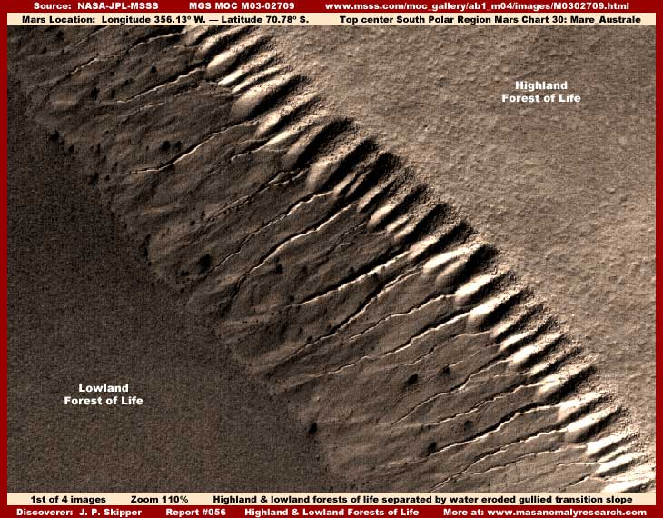
The above first image demonstrates the edge of a broad lowland pit area in the lower left corner and the edge of a broad upland tableland area in the upper right corner. A big long bluff system with a slope down from the upland area on the right forms a transition to the lowland on the left. As you can see, the slope has many deep gully systems down its embankment and these gullies clearly appear to have been formed by liquid surface water erosion flows downhill from our right to left.
Also seen are what appear to be many light color individual eroded bluff systems near the top of the slope reflecting a lot of sunlight. Geologically, it is assumed that these bluffs represent a previous extension of the upland tableland out to this point which has been eroded away by the water flows from the upland down this slope leaving these bluff as the last residual part of the upper tableland still resisting collapse down the slope into the lowlands.
Finally, we get to what was initially the main target for this report, the possibility of massive forest evidence carpeting both the lowland and upland in this area. I've been holding evidence like this back for a long time and I'll get to the reason for that a little further down this report. What you see densely carpeting both the lowland and upland in the image above is just a representative sample of this uniform texture that extends all over the strip and off of it and in a number of other strips as well. It all looks basically the same, so there is little reason to waste much image space here on it.
If you will look very close in the above first image, you will see what appears to be rough texture scattered and thinning portion of the upland tableland covering extending out onto the bluffs right in the top areas as well as down into the top areas of the gully systems. This to is very suggestive of upper tableland vegetation densely packed forest extending out onto and trying to establish a foothold in this more unstable terrain where well drained dry conditions and water erosion keeps having its way.
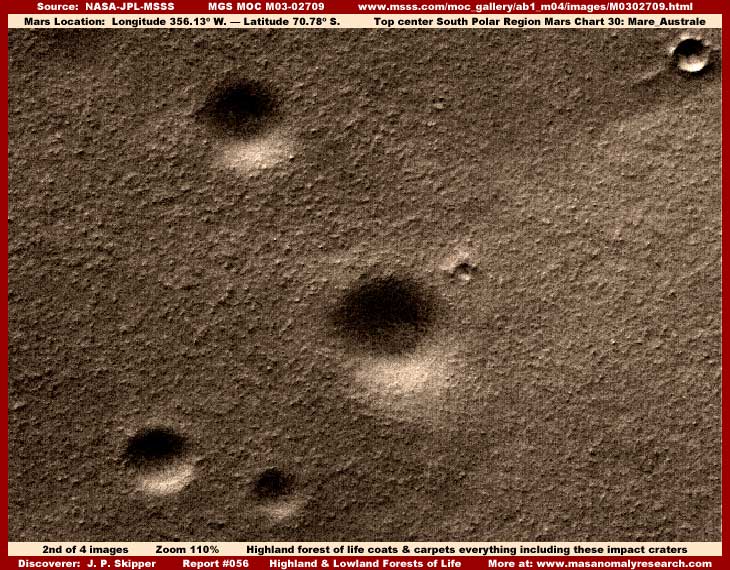
My above second image demonstrates more of this uniform texture and its impact on the terrain. In this case, we have a scene from the upland tableland and I've included a image of this particular spot because it demonstrates what clearly appear to be six varying size round impact crater pits.
Note that what appears to be dense carpeting of some kind engulfs, fills and obscures the four largest craters rounding and smoothing what should normally be more sharply defined edges and interiors into smooth textured contours. This evidence of the complete carpeting of this terrain tending to level it out as well as engulfing the craters and hiding all true geological ground detail from view, except for vague true terrain outlines, would appear on the surface to suggest evidence of a forest of vegetation in its most aggressive and unchecked state, just seen from a great distance where individual detail can't really be seen because it all merges and runs together forming this uniform texture pattern.
Sir Arthur C. Clarke has made recent public comments that he believes there is vegetation on Mars and the psychological boost such comments from a person of his well known stature gives the Mars anomaly research effort in general an appreciated boost in the media. There is indeed vegetation on Mars and a lot of it. As many of you know, I've reported on the most obvious gigantic forms of this vegetation evidence because such huge forms show more detail and are more obvious in this poor satellite imaging.
However, Sir Arthur also tells me personally that he does not believe in the image tampering nor does he believe that a secret like the image tampering could be kept for so long by so many. I suspect that in general this incredulity is shared by many if not most in the public who find such a possibility just too difficult to believe because, if true, it would have very disturbing implications. Also Sir Arthur has many contacts in official high places of long standing in traditional planetary research and has a certain investment of trust in those contacts and what they tell him giving him incentive to be very conservative in this regard. Further, being very conservatively incredulous in general is also a part of his public persona.
Well Sir Arthur, I deal in evidence, follow where it leads, and try not to get out in front of it with my own personal preferences. In fact, when it comes to this particular report, I was personally disappointed when digging deeper into what appeared at first to be "forest" vegetation evidence began pointing in a different direction, one that I am personally dislike reporting on. The truth is that closer analysis reveals that we are probably looking at a extensive massive image tampering here designed to create an illusion.
The main thrust of the illusion element is not so much to suggest forest evidence but to divert attention and any possibility of subsequent debate from apparently the fact that a broad region has been covered over with complete blot out carpet of image tampering. The illusion detail that suggests but does not confirm forests is thrown in just to distract and divert attention from what we are really looking at here, which is nothing at all.
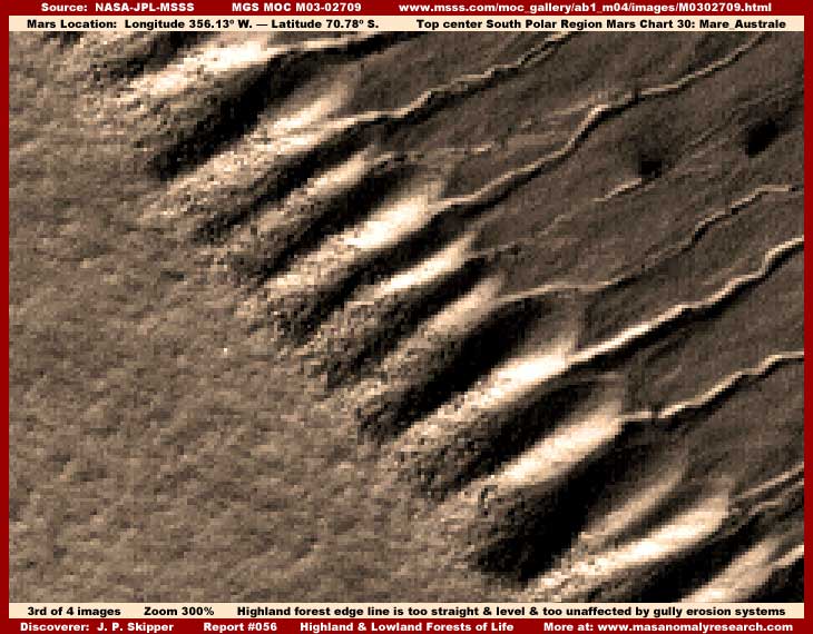
The above third image shows a close up view of a portion of the top of the slope seen in my first image here but this is a view flipped vertically and horizontally. I did not actually flip the image myself but used the orientation of the third listed image at MSSS, which orientation is different than the first listed image, and already offers this flipped view. Here in the above closer image you can see the upland texture suggesting vegetation forest in the lower left, the light reflective bluffs, the water erosion gullies, and part of the slope down to the lowland tableland area not seen here.
This view tells the real story. First, even though the edge appears ragged, I want you to note how generally straight and uniform the demarcation line is separating the upland coating from the bluff systems and how this coating crosses over the tops of the uneven gully systems without conforming to their irregularities in the slightest. Second and more specifically, note how the erosion gullies, as large as they are, do not extend up into the highland tableland at all but disappear under it and are simply cut off by that upland coating demarcation line. This is the most important evidence of all tipping us off to what we're really looking at here is a artificially applied coating and nothing natural in the terrain.
The geological transition from uniform level upland tableland to the gullies just would not be like this. The edge could be expected to be more irregular and the "vegetation," as thick as it is, would be following the high and low contours of the gullies as they ate irregularly into the upper tableland over such a long expanse line. The vegetation appearance is just too level and too straight and crosses across what should be gully depressions with nary a bobble. This factor confirms that everything to the left of the demarcation line is not natural geological terrain at all including not thick forest vegetation but actually thick carpeting image tampering even though it might have at first from a distance flipped view looked like the top surface of a densely packed vegetation forest.
But, what about evidence to the right of the demarcation line down the slope? In my first image here, one could have expected that the spotty lumpy objects at the top of each bluff just below the vegetation demarcation line would be individual clumps of vegetation venturing out of the crowded densely packed forest and onto the eroded bluffs. Had this been natural geology we are looking at there, this would have been a more hostile place because it would have been too well drained and much dryer than the flattened upland terrain and the ongoing erosion would have created collapsing unstable soil conditions over time. So one could have expected the vegetation clumps here to be more scattered and sparse, which is just how they appear without closer examination.
However, in my above third much closer image, the sparse vegetation clump evidence on the "bluffs" tends to look more like hard object rectangular cubic structure forms rather than the softer forms of vegetation. The closer I look, the more this looks like civilization evidence, just distantly seen at the edge of resolution with tampering applications on it no doubt done at closer resolutions not released to the public.
In fact, although the resolution is too poor to show it adequately here in these presentation images, very close examination indicates that the light reflection bluff areas themselves are not bluff geology at all but are lines of rectangular hard objects oversaturated with a light color blur tampering alternating with dark color tampering to create a shadow effect and thereby the individual bluff illusion look. Even the medium dark color slope areas between the gullies further down the slope appears to be a medium darker color dither tampering application done at close resolution and again over rectangular structures.
Additionally, close inspection of the dense carpeting "forest" areas tends to indicate that this may be a uniform application of overlapping geometric forms type of tampering application that provides a false texture pattern to the surface. I have seen this used extensively in very wide areas, including in the northern hemisphere where some scientists have made the observation that there is an unusually high amount of sand, even though there is a distinct absence of normal sand dunes that one might expect to see. It isn't sand or sediment, rather it appears upon close inspection to be a light color version of this same total blot out type of image tampering, just with a little less "texture."
Truthfully, I doubt that we are seeing anything real at all except possibly a portion of the gully systems only. So, is the "forest" evidence worthless? What are we to believe here in this land of carefully crafted illusions?
What we must keep in mind is that image tampering is done for a purpose and that purpose is evidence to. So far, as I have been able to determine, tampering mostly hides civilization evidence. However, readily apparent massive wide region forest evidence would also be an immediate tip off that temperatures on Mars are not nearly as cold as officially promoted nor would atmospheric conditions be as thin as promoted either in the presence of such a huge oxygen pump. Therefore, it is logical that tampering would extend to any massive forest evidence as a target secondary to civilization evidence and that may be a consideration here.
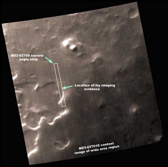
The above fourth image is the companion M03-02710 context wide-angle image of the wider area region from which the M03-02709 narrow-angle image strip evidence in my first, second, and third images here was taken. In this image you can see the uplands and lowlands and the uniform dark non-reflectiveness of the region terrain except for the slope areas facing and reflecting sunlight or casting shadows.
With an apparent lower sun angle, the dark smoother areas could be porous dark color vegetation surface absorbing a lot of the sunlight and therefore providing the non-reflective quality. However, the sunlight reflectivity on the bluff systems indicates that there is still some very strong sunlight and yet there is essentially no light reflectivity in the rest of the terrain and there should be. It is more likely that this is image tampering applications, just seen here from a greater distance at poorer resolution. As a coating, it hides all reflectiveness in the terrain beneath its application leaving only the sun facing highland to lowland slopes to reflect any sunlight.
The point is that this one wide-angle image demonstrates the huge regional area involved and it even extends far beyond the boundaries of this wide-angle context image as well. It is hard to imagine that image tampering over such a large area could all be hiding only civilization evidence in the South Polar region. If it is, in my opinion, this would have disturbing implications as to populations far out of control on Mars and probably severely over taxing natural resources.
If that were true and assuming oxygen breathing going on, such out of control population density might also contribute significantly to thin oxygen atmospheric conditions on the planet as too much population breaths in oxygen and pump out CO2. Yet, the evidence in my last report #055 titled "Towers in the Sun" carries just such over population implications in the middle hemisphere of the planet around the 0º Latitude and 0º Longitiude. Could all this South Polar region massive area of image tampering be hiding nothing but civilization evidence as it usually does?
In my above second image, although a level and essentially flat application, note the very uniform"bumpy" texture or pattern detail of the "terrain." In my experience with observing the different forms of image tampering in this satellite data, this can very likely be explained by applications done at very close resolutions (not made publicly available) that map the application in among higher and lower object forms leaving the tops of the highest forms out to provide disguising surface detail.
In other reports, we've seen that this is just how the tampering does in broad areas of terrain where larger higher land forms such as ridge tops and crater rims are left sticking out of the tampering application to provide a little surface detail to help disguise the presence of the tampering. In civilization evidence in the form of building structures, it usually maps around the base and sides of the buildings at very close resolutions but often leaving the tops of the buildings out to provide a texture detail.
As a coating covering everything except the tips of taller objects, this would explain the uniform all encompassing and engulfing flat levelness devoid of any other type of detail except the outline of broad larger objects like crater pits below it where it flows over, down into, and then out of an occasional impact crater pit or over other more gross variations in the unseen true underlying geological terrain leaving only a rounded smoothed vague appearing form without any sharper detail behind.
This would explain the terrain textured surface best seen in my second image here. But, it would also explain a lot of other evidence that I have where I have suspected dense forest are present but covered up by coatings like this. Many of these kind of sites have also been oversaturated with a light color trying to make them appear as reflective snow (probably assuming CO2 snow) with this same textured surface to support the official position of extreme freezing conditions on the planet.
As an example of similar evidence of this type of suspected texture tampering, take a look at the imaging in my previous reports listed below. In these reports note the terrain surrounding the main reported on anomalies.
Report #026 titled "Dissecting a Water Find: Part 3"
Report #041 titled "Life Invades Huge Mount"
Report #045 titled "The Real Tubes on Mars: Part I"
Report #046 titled "The Real Tubes on Mars: Part II"
Note that the tampering software tends to map to the existing topography making its applications onto intricate parts of it rather than superimposing a completely artificial pattern on top of it all. Since each area's topography is subtly different, then the texture coating in each is also subtly different as it coats and covers but at the same time partially blends in with the terrain.
The proof of this type of mapping to existing topography is demonstrated on a more coarse level in my above second image here. There the software application maps up over and down into the impact craters you see there taking on at least a semblance of their detail but also at the same time softening the general shape as well as destroying all true but lesser mid to small size geological detail in the scene completely that should be there but is not.
This is how the tampering software provides constant subtle change from one area of application to another and furthers preventing recognition of itself for what it truly is. These kinds of applications also require being done at much closer imaging resolutions that have never been released to the public or admitted to. The closer resolution is required for the software to properly map into all the nooks and crannies of smaller detail evidence like densely packed buildings and intertwined vegetative forest.
On other hand, the mapping process must have a natural topography pattern to map to. The fact that the pattern is so uniform over such a wide area and yet apparently the pattern does not repeat itself, suggest equally uniform evidence below it that it is mapping to. I've seen a fair amount of civilization evidence on Mars and what I've seen just simply is never quite this uniform with such very fine detail over such a huge area.
Since the tampering may not be a completely artificial carpeting overlay and may partially map to the terrain it is dealing with, underlying natural forest evidence (very tiny detail) could adequately explain this very fine uniformity of the tampering coating's texture. Yet the evidence peaking out at the edges of this carpet tampering on the bluffs and slopes between the upland and lowland terrains also indicates that civilization evidence is part of this scenario to and cannot be overlooked.
Therefore, I suspect that what is under such a broad region of image tampering is both the usual civilization evidence as well as being intermixed with true forest evidence providing the finer texture. Obviously, I have arrived at this conclusion via logical extrapolation from the evidence as explained here. However, since no direct visual forest evidence or anything else can be seen under this broad area carpet tampering, this is an opinion and not to be confused with fact.
Remember, tampering is done for a reason, we have come to learn what that reason is, and that reason is evidence to. Whether the tampering is covering vegetation forests or massed civilization evidence or both, the bottom is that such dense carpet tampering over such a huge broad region is covering forests of life of some kind and a lot of it in the South Polar region. That's the whole point of this report and why it is so titled.
SUMMARY
What we have here in the official strip and in my first image above is what little the secrecy agenda is willing for us to see and consider. That consists of the obvious water gully erosion evidence down a slope from upland to lowland and little else. However, with the tampering all over and around it, even that is inconclusive as to whether this erosion is fairly recent or in the very distant past leaving the question of current water presence itself tantalizing but equally inconclusive by design.
Then from the secrecy agenda point of view, although hopefully it want happen, if anyone does look closer and notice more, such as represented in my second image here demonstrating the carpeting effect engulfing and covering everything in the terrain, one becomes aware that there is "something" densely carpeting the landscape and completely hiding the natural geology and geography from view except for some vague outlines. If one progresses that far in analyzing the scene, the pattern and texture that is carpeting everything is suggestive of vegetation forest as a less than desirable but still somewhat acceptable alternative, mostly because that suggestion is ultimately unresolveable and therefore inconclusive due to the limitations of the visual evidence.
What the secrecy agenda obviously did not want to be noticed are the innate flaws in the tampering carpeting effect application itself such as where the edge of it travels over the tops of the gully systems so straight and perfectly level with a too well defined terminating edge boundary but without conforming even in the slightest to the gully system's uneven eroded terrain under the edge of it. This clearly demonstrates that the carpeting effect is not vegetative forests or anything natural but an artificial image tampering overlay creating an illusion.
Further, the light color bluff systems also appear to be illusions created by the image tampering attempting to hide geometric structure evidence suggestive of civilization and are probably not true bluff systems at all. Likewise the slopes themselves have a dithering tampering application on them creating that uniform blank smooth surface look as slopes. So it is possible here that the gully systems are themselves not real at all and are yet more illusions created by tampering in this terrain.
All of the extensive and sophisticated tampering in the Mars satellite imaging like this over a very large area in the South Polar region clearly demonstrates a serious effort at hiding something very extensive and reveals a very serious commitment to a full blown secrecy agenda. Obviously, no one would be going to this much trouble and substantial expense to hide rocks and natural geology.
So the answer is obviously that the tampering is hiding life of some kind and an awful lot of it to unless you don't trust your own intellect and need someone else to tell you what they want you to think.
SUMMARY POINTS
(1) Image tampering is solid hard evidence of what ever it covers up.
(2) Such massive tampering demonstrates a serious extensive secrecy agenda.
(3) Process of elimination points logically to hiding civilization and/or biological life evidence.
(4) Logically civilization and/or biological life evidence is likely very extensive in this region.
DOCUMENTATION
The easiest way to verify the visual evidence here behind me is to access the official science data at the MSSS website link below. The site I've imaged and reported on here is about 70% of the way down the strip in the middle and on the right.
http://www.msss.com/moc_gallery/ab1_m04/images/M0302709.html: This link accesses the MGS MOC M03-02709 official science data strip. Note that the first listed faster loading JPEG sinusoidal (angled) strip works, has the same orientation, and will provide a decent look at the evidence as presented in my first and second images here, even though on a smaller scale. However, note that the second listed GIF sinusoidal strip does not work. The third listed GIF straight strip does work but has been flipped horizontally and vertically at official level. Use this third strip with a graphics program to zoom in and clarify to replicate the revealing evidence in my third image above.
, Investigator
![]()