
THE REAL TUBES ON MARS
Part 1
Report #045
October 30, 2002
can be contacted at
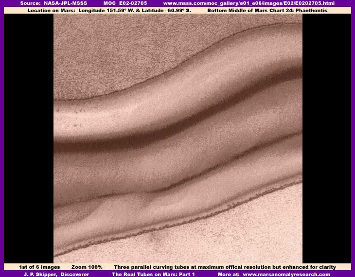
Within a couple of weeks of the first MOC science data images finally being released to the world back in midyear 2000, one of the very first important anomalous discoveries back then on Mars was a distantly seen long object down in a long crevasse that appeared at first to be very similar to a strange looking ribbed or segmented tube system. This was at first identified by the discoverer as a glass tube system and my own speculation went on to expand that this represented life of some kind. Back then I didn't even have graphics software, depended on the imaging of others, and to some extent on their well known reputations as skilled planetary observers and experts in this area. My observations back then were influenced by my own ignorance in this regard, so I jumped on this interpretation band wagon myself because those "tubes" clearly represented life of some kind and my introduction of this to the public in a piece titled "The Real Smoking Gun as to Life on Mars" went around the world and is still circulating but often with misinterpretations of my original comments.
However, soon I obtained graphics software and started investigating direct in the science data for myself much closer and more carefully. I quickly determined that the "tubes" were actually a long line of many side-by-side short ridges parallel to each other built by some life form operating in shallow water flowing down a slope on one side of a long trough system. The many ridges were actually formed on one slope of the trough system in shallow water flowing down that slope and confined visually width wise and elongated length wise due to the long length of the trough system's slope. Looking at them down their long length but short width created this segmented "tube" form appearance in basic. This appearance was further refined and enhanced visually by the confining effect of image tampering on either side of the site's water flow slope. Back then I was just beginning to be exposed to and did not fully understand the presence of the image tampering and how it altered the look of site's and even created illusions.
Since that stumbling beginning in this planetary research, I have had to back off of my original interpretive position on the "tubes" and to some extent eat some crow. I have long ago reported more than once what these particular anomalies really are. Take a look at my very first public report #001 titled "The Real Smoking Gun as to Life on Mars." This was my very first public report of any kind, including this subject. Then there is a second follow-up attempt at clarification on this subject report #018 titled "The Tubes: Natural Geology or Life." However, please understand that my initial inaccuracies and the continued inaccuracies of others as to certain details in no way changes the over all fact that this early find still represents the discovery of life and therefore continues to merit the title "The Real Smoking Gun as to Life on Mars."
Just be aware that, although these sites do represent the activity of living organisms of some kind and therefore represent LIFE itself, they are not fanciful glass tubes, worms, roots or anything like this that others seem to continue to want to promote, including the initial discoverer. Even now over two years of research experience later, there continue to be those who should know better but who are still insisting on reporting the anomalies in terms of such high drama website traffic building inaccuracy as tubes and worms. But, that isn't the worst of it, continuing on this path by those who should by now clearly know better, especially if they have continued their research into and gained extensive experience with the MGS MOC imaging, is very suspicious behavior and brings up the question of ongoing intentional misdirection away from the truth that these sites are associated with liquid surface water on Mars.
In any case, as you can see in the above first and subsequent images here, there are some very real and incredibly huge tube systems on Mars. They aren't the misinterpreted ridges down a slope but the legitimate very smooth tube systems you see presented here down inside this double crater system. Please keep in mind that the above first E02-02705 image is the official 100% view and yet these objects are still giant looking even at this great distance. For example, whole cities could fit in these tube systems. Even with this distant poor quality imaging, note how sharply defined they are relative to the surrounding terrain. Note also that the outside or top tube is the most fully formed of the three and this factor is also present in other images of other different tube systems similar to these forming a repeating pattern of evidence.
However, be aware that the distance is too great and the size scale too small to be drawing any conclusions either way about the surrounding terrain detail. Still, note at least the overall texture and pattern of the open terrain above the main tube. As the tubes evidence in this report and others to come is presented, you will see that this texture and pattern is repeated over and over again in the terrain bordering on these main outside or top tubes regardless of the locale general geology or topography the tubes are found in. While I do not as yet have any explanation for this, it is a repeating pattern of evidence that should not be ignored as it clearly has something to do with and/or a relationship with the huge tubes it borders on.
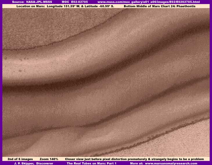
The above second E02-02705 based image represents a closer view. However, note that this is only a minor 40% increase in size just before pixel distortion becomes a serious negative factor. Normally we could expect a increase of 100%-200% or more before encountering that much distortion and that's a lot of difference. If it wasn't for the unusually degraded resolution, we might be able to tell a lot more about the smaller details in the surrounding terrain. Further, almost every image of this general region is like this all across the various MOC AB1 through E06 imaging series. Many of the images, at official 100% resolution, are like looking through a fine gauze fabric that effectively cuts resolution more than normal.
I have seen this before in certain other regions and have come to associate this with overall resolution image tampering where there is probably too much evidence going on in the terrain smaller detail all over the strips of that region that they don't want to be seen and wholesale tampering techniques that obfuscate everything are the preferred tactic to deal with this smaller surrounding terrain detail but it also impacts the huge tube visuals as well. This is most prevalent where giant objects are in the strip as the only thing to compare against and human behavior tends to force perception of these object to normal size and likewise with the surrounding terrain. The secrecy types know this and capitalize on it.
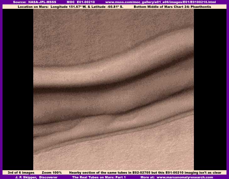
The above third image evidence is from a different E01-00210 strip but still in the same crater location and is the same tube system. Here the scene is the same site as in the first and second images, except offset just ever so slightly to the left or west of the E02-02705 strip. Although I've clarified it as best I can, the image quality is also poorer than in strip E02-02705 resulting in a more blur and a less detail even at the official 100% resolution. I include it here only to make you aware of its existence and that it represents the furthest view to the left or west portion of this particular tube system.
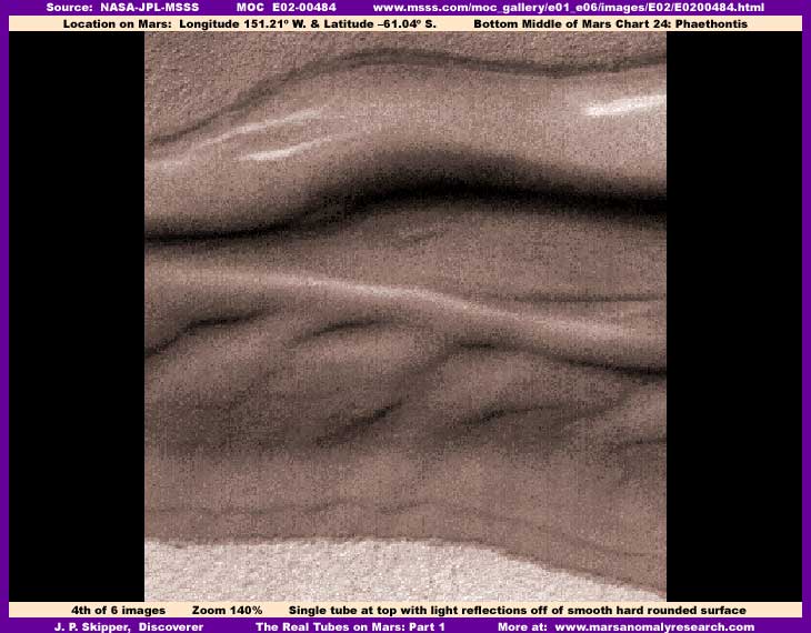
The above fourth E02-00484 based image is from yet another different strip but still in the same crater location and is of the same tube system. The coordinates tell us that this scene is a little to the right or east of the first three images. As you can see, the outside or top tube remains full blown, rounded, smooth, and, now at this sun angle at the time of day this strip was taken, it even demonstrates light reflections off of the tube's glassy smooth top surface and even shows indentations down the length axis of that surface. The occlusion and lack of visual detail inside the main tube may be a function of the contents, habitat light filtering interior coating, or it may be a result of image tampering or any combination of these. Also, we may be seeing a clear tube full of water that is distorting the view of the bottom ground the tube is sitting on to as seen through the total tube's girth. Also, remember the great distance and size scale involved here and the fact that we can see these only because of their tremendous colossal size. With that in mind the tube contents may be on such a small and uniform size scale that, when seen from such a great distance, such small detail just merges into this smooth indistinct appearance.
However, just as important, in this portion of the system, note that the middle and lower tubes are now diminished, less well formed, lower profile in appearance, and essentially no longer recognizable as full blown elevated tubes. Note though that the total mass of the system still remains intact, sharply defined, and well differentiated from the surrounding terrain indicating that it is probably a single gigantic cohesive mass. While we can't make an assumption as to whether a process of early stage inflation or later stage deterioration deflation is going on, it appears clear that one process or the other is at work here and we are seeing a dynamic changing cohesive mass ecology that strongly suggest LIFE of some kind.
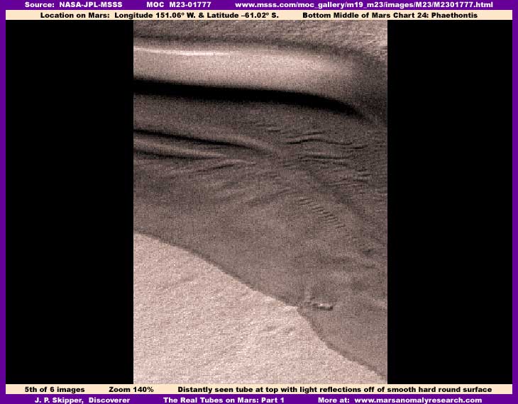
The above fifth M23-01777 based image is from still another strip in the same crater and of the same tube system. The coordinates tell us that this final scene is a little further to the right or east of the previous image views and in fact represents the eastern most view in which at least one full blown tube is visible. Although even more distantly seen in this strip, the outside or top tube is still mostly fully formed and again with light gleaming off of its smooth rounded surface while the middle and bottom tubes are now essentially gone and only a flattened out mass is present. Even so, you can see that the mass is still sharply defined and well differentiated from its immediate terrain environment and this again strongly indicates that it remains a cohesive mass that adheres to itself as well differentiated from the surrounding terrain and, as such, can't remotely be considered a "dune" collection of dry particulate matter as the official general catch-all explanation implies.
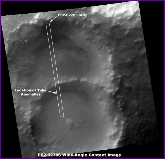
The above sixth E02-02706 based image is the wide-angle companion context image for the E02-02705 narrow-angle strip and shows the dual crater system. The anomalies presented here are found in the upper portion of the lower and more recent of the two craters and are located just below and at the base of the crater's north interior wall as I've pointed out with an arrow. The vague narrow dark color band you see there is this tube system mass. The further left or west one goes in this dark band area away from my arrow's point, the more the giant tubes dominate and the more well formed they are with little or no lower profile mass associated with them. The further right or east one goes in this dark now more broadening band, the less the tubes are present but there remains a thick, more spreading and low profile cohesive mass with folds like thick, flowing, slumping, congealed paint poured out on the ground and still well differentiated from the surrounding terrain.
Every time science officials interpreting the Mars visual science data see a smooth or lumpy surfaced mass well differentiated from its surrounding terrain and no matter what its shape or how unusual or anomalous it may appear, they always refer to it as "dunes" or "defrosting dunes." The dictionary defines a dune as a "sand hill or sand ridge formed by the wind." Now these people don't usually mention the word "sand," just the word "dunes" and that leaves a tiny back escape door available to them as to definition interpretation. Their point appears to be that the concept of sand on a large scale is most often associated with dry arid conditions here on Earth. Obviously then the idea is to continue pounding home this basic concept message in as many ways as possible that Mars is a frozen, dry as dust, dead world and therefore there is nothing there to get excited or enthusiastic about. In other words, trust us!
However, in my experience, very little of what they identify as "dunes" are actually associated with sand or any dunes as we are familiar with the concept here on Earth. While others are something else entirely, a good number of these officially identified "dunes" are actually ice masses formed by liquid water welling up from below and freezing on the surface and their size can be anything from small to every bit the size of great hills or mountains. Dark tinted standing liquid water on crater floors as well as lumpy and wavy water ice masses are also officially misidentified in this way.
It is my belief, after a fair amount of experience now at researching this MGS MOC evidence, that the dark color band you see just inside the crater's north interior wall originally probably started off as a water ice mass similar to what I have seen so many times elsewhere on Mars, including in this particular area. This kind of dark color band, when seen from a greater distance in wide-angle MOC strips, is often seen in a great many craters, pits and depressions all over Mars and to a much lesser degree in open terrain as well. In the northern and southern hemispheres, when not completely filling a crater or pit bottom and occupying only a portion of the crater floor, it is most often located in the northern portion of the crater hugging the base of the interior crater wall and less often in the southern portion.
Remember, depending on the nature and size of the impact object's mass, the terrain's composition that it strikes, the angle of impact and other factors, impact craters are often a little deeper at the crater's interior outer edge than in the middle. In fact, in the above sixth image associated with this particular evidence site, you can clearly see a portion of obviously elevated terrain right in the middle of this crater. This is probably a remnant left of the impact object's core mass. The point is that the dark band no doubt represents the lowest point on the crater floor where we might logically expect a upwelling fluid to initially collect and then turn to ice.
However, oddly enough, these statements of ice mass northern locations within depressions applies only to those north of Latitude –65º in the northern and southern hemispheres. The ones just south of this site across the –65º line in the South Polar Region are often the reverse of this. Most of these occupy the depression's interior wall base oriented south toward the South Pole. I have no explanation for this reversal, only observe it as evidence.
In fact, while I haven't had time to report on it yet, except a bit in the upcoming book evidence record not yet released, the South Polar Region has a very high frequency of liquid water upwelling and forming into surface ice masses. The tubes anomaly site reported on here is in the bottom of the Southern Hemisphere just north over the Latitude –65º South Polar Region vs. Southern Hemisphere boundary line and about as close to the South Polar Region as you can get without being in it. Further, the many image strips of the immediate Southern Hemisphere region surrounding this dual crater impact site demonstrates a unusually large number of the spotted water ice masses. These masses are mostly characterized by being basically light colored with many dark spots, hilly, and sharply differentiated from their surrounding terrain. Conversely, just south over the –65º line in the South Polar Region buts still in the same general area we are reporting on here, they have similar characteristics but are predominantly a very dark color and show the same signs of the tough pliable cohesive mass as the evidence I am reporting on here.
Observation wise, it seems that in general when these ice masses change to a darker color, the water mass has actually undergone a change by an unknown process (possibly by elements in the water but, in my opinion, more probably by a natural life organism in the water that tints it dark and is able to manipulate its water environment to an extent) to a tough solid undulating surface. In the northern and southern hemispheres, they sometimes look similar to close packed, soft top, rolling water wave forms but are more regular and uniform than natural water waves. Some amateur researchers have even mistaken these dark wave form wide-area masses for liquid surface water with waves in it because it looks very much like that at just a surface look. It is my speculation that the gel or solidification process prevents further evaporation of the ice mass on its surface and maintains by intent its essential but now altered water components for the organism's survival. In the northern and southern hemispheres, this happens more often with shallow, still and pooling liquid surface water in low places rather than with already established ice masses, but that's all another story that would take a entire extended research work or book to present properly. Although I caught onto this almost from the beginning of my Mars investigation work back in midyear 2000, the time factor necessary to prepare and present this complexity with huge numbers of images is why I have put off reporting on it for so long.
With that background in mind, I suspect that this particular anomaly site reported on here started out as a water ice mass similar to those in nearby craters in the region but life of some kind has come along, intervened, made alternations to it, and transformed the entire mass first into a cohesive tough surface encapsulating mass and then later into what we now see in this evidence with these colossal elevated tube forms. It is possible that this is started by some form of natural biological life as I see evidence of the basics of this process all over Mars where pooling still water or ice masses are present and I therefore know that this exists. However, I also suspect that an advanced technology we do not understand has been introduced to again transform and create these giant elevated hollow tube forms, probably for the purpose of creating sealed and armored habitat or storage systems inside.
The whole point here is that, the official descriptor "dunes" implying a accumulation of piled dry particulate is not only inaccurate, it amounts to misdirection. A more thorough examination of this evidence strongly indicates that these so called "dunes" are in fact the direct opposite of that. They appear to be a single colossal, tough, somewhat pliable, cohesive mass probably originally based on water that does not mix with the terrain it sits in. The great tubes are obviously expanded and formed from within this pliable cohesive mass. This may start off on a small not well formed scale not as big and massive as the tubes we see here but lower profile, irregular, and perhaps camouflaged mimicking and perhaps even being sort of disguised in with the original ice mass ridge field appearance? Later when growth forces expansion change, the big massive tube systems may be developed and expanded in place providing more room. Alternatively, perhaps the life form that is doing this is an evolved aquatic form surviving and moving in underground water to the underside of these surface water masses and transforming them into above ground interior water habitats where the precious water is preserved from evaporation and concentrated into these huge elevated tube storage and/or habitat systems? Interesting speculation. Maybe additional information will one day help resolve these questions.
However, make no mistake about it, the one thing that is pretty clear here is that these are the real giant tube systems on Mars, at least the ones we can see on the Martian surface, and they represent the activity of life of some kind on Mars. If the giant tube systems actually represents intelligent life artificial structure evidence, as it so much appears, those who have been following my reports can perhaps now see a little more clearly why I am very suspicious that the great interconnected ridge lines seen in previous report #036 titled "Inca City Ridges" represent a form of colossal tube systems, just covered with massive amounts of fill forming great interconnected natural appearing ridge systems. In other words, not so much buried as laid out on the surface and covered.
Just in case some viewers may be skeptical about my speculation as to these monster tubes being covered to appear part of the natural terrain, take a look at previous report #035 titled "Buried Tube System" where the covering fill has been partially removed from and exposing a section of the smooth translucent dome top material, probably to provide light into the interior of one of these tube systems. The hard evidence of colossal tube systems on the surface here makes the case for covered giant tube systems more believable. So you see, while it is still questioning speculation at this point, it is to some extent still informed speculation based on some hard science evidentiary data evidence and not the author's purely wild leaps of emotion and imagination as some may prefer you to believe based on their own preconceptions, prejudices, and/or hidden agendas.
One more thought, those who who plan manned missions to Mars based on confident assumptions that it is a dead world devoid of life and all they will have to deal with are mission technical issues to get there and back as well as extreme cold and very thin atmospheric conditions once they get there had better wake-up and smell the true Mars reality. If they don't start questioning their assumptions, they could be in for a very rude and even dangerous awakening. Such a mission potentially based on some serious and very basic misperceptions and/or misjudgments could be dangerous not only to some brave astronauts but to Earth itself depending entirely on how life on the other end of this scenario interprets such an ill-prepared first contact. It is not hard to imagine a scenario of misunderstanding where man in his myopic self focus lands on a distant planet thinking to find it deserted only to discover it is thoroughly occupied and, worse, considering itself unceremoniously invaded. Not a good thing to put it mildly!
Meanwhile, this report is not all of the evidence on these colossal tube systems in this region. There will be another Part II report on yet more of these monster tubes in different locations following on the heels of this Part I report. Anticipate that the imaging on those will be at least a little better and a little more telling. Look for it.
DOCUMENTATION
To check behind me and confirm the evidence presented here, the easiest official science data source to access is at MSSS at the links below. If you just want to confirm the basics of the tubes being present in the science data to confirm legitimacy, then choose the first listed faster loading JPEG strip there for your convenience. However, all of the official images of this anomaly site are quite dark and the strips are all narrow with very distant views. Therefore, if you want to examine the anomalies with better imaging as you see here, you will want to download the slower loading but higher detail GIF strip and bring it into a good graphics software program to zoom in and lighten, sharpen, and clean it up. The lightening and contrast graphic tools will need to be used the most.
MSSS ..... http://www.msss.com/moc_gallery/e01_e06/images/E02/E0202705.html
MSSS ..... http://www.msss.com/moc_gallery/e01_e06/images/E01/E0100210.html
MSSS ..... http://www.msss.com/moc_gallery/e01_e06/images/E02/E0200484.html
MSSS ..... http://www.msss.com/moc_gallery/m19_m23/images/M23/M2301777.html
, Investigator
Related Links to this report include:
Dissecting The Mars 'Tubes' Anomaly - (6-23-00 @ Rense.com)
The Real Smoking Gun As To Life On Mars! - (6-27-00 @ Rense.com)
![]()