
MARS SOUTH POLAR RING
ANOMALY
Report #079
December 15, 2004
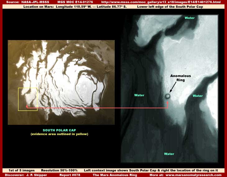
The above first image demonstrates both the huge perfectly round ring that is the subject of this report and its location on the lower left edge of the South Polar Cap. It sits there like a carbuncle on a foot and very out of place on this Polar Cap ice mass. Remember that these Cap ice mass forms are tremendous size terrain forms distantly seen in these images and so this ring shaped site is also very large. Further, it is unique in that there is nothing else like it anywhere else on Mars, at least that I have found.
First, you should know that it is not an impact crater. In basic, this perfectly round object is a huge but shallow round ring shape depression in the huge Cap ice mass it sits is on. It is located on the edge of the ice mass where it intersects as a shoreline with a deep open liquid surface water sea as indicated in my last report #077 titled "Mars South Polar Flood Waters." You should also know that the general ring site appears to be subject to being seasonally submerged in shallow water when water level conditions are seasonally high. This may flood the ring's interior to some extent and then later, when the high water levels seasonally recede from the overall site, the area around the ring is left high and dry but some dark water may be left isolated inside the ring depression contributing to staining it the darker color you see here for a longer period extending beyond the flood season.
In fact, in both of the above context images taken on April 27, 2000 for the left image and March 18, 2002 for the right, this area of the Cap is in high water conditions and likely in the process of flooding the ring site. The dark color of the ring in probably at least in part caused by the deeper dark water in the deeper part of the depression providing the ring shaped look. Additionally, some of the dark color organisms in the water also described in previous report #077 are likely annually trapped in the ring depression when the dryer season returns and high water levels seasonally recede away from the ring.
Since the organisms would then be isolated in the ring along with water during the months of the dryer seasonal cycle, there may be a eventual mass die off of the organisms or perhaps they also transform into a dormant and inactive state or both as colder dryer conditions return. Their inert bodies likely sink to and concentrate on the bottom carpeting and coating the ring interior area with dark color stain. If so, when later seasonal warming trends start coming back, the darker color of the ring can be anticipated to absorb more solar radiation energy (heat) than the much lighter color highly reflective surrounding ice mass surfaces causing increased and earlier warming within the darker ring area and more moderate temperature conditions than the immediate surrounding environment.
In other words, there is likely a ecological dynamic going on here in this generally cold weather environment enabled by the seasonal heating and cooling cycles, the seasonally plentiful melt water, and the dark tinted opportunistic organism specializing in taking advantage of these conditions. That is the overall and partially speculative beyond the evidence interpretation but there is more to this anomalous ring site than that, as you will begin to understand in the closer view narrow-angle imaging evidence below.
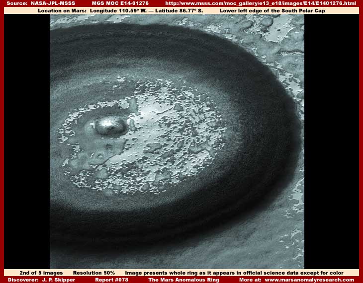
The above second image is a closer but still distant view demonstrating the entire ring as it appears in the official science data imaging. This site is huge and too large for the narrow-angle imaging to encompass it all, so there is no closer view narrow-angle imaging data that shows the entire intact ring. All of the available images chop off various portions of the ring. Even though this particular E14-01276 image sourced from here has slightly higher resolution than the available others and therefore slightly better visual detail, the view is still too distant making it difficult detail wise to determine what this site might be.
Even so, the dark thick outer rim is a gradually sloped shallow depression where it slopes down from outer relatively level open terrain areas into the dark color ring depression and then gradually slopes back up to what appears to be a raised center and relatively level area within the middle of the ring. It appears likely that all of the terrain around the ring and in the center of the ring has a similar relatively flat level. Close examination of the dryer stage images listed separately in report #077 with all their map type image tampering applications confirms via the tampering mapping into the ring and coating over it that this apparently is at the very least a shallow but sharply defined round ring depression and that the terrain around it is likely relatively flat and level.
The smaller distinctly round place within the center area of the ring slightly offset to the left of center clearly appears to also be a depression. However, skilled image tampering at this spot precludes being able to be definitive about this. That means that I do not trust the provided visuals of this particular feature. I suspect skilled tampering could be creating this depression interpretation as an illusion and this could just as easily be an elevated form like a group of multiple very large elevated objects hidden under the tampering illusion? I cannot be sure.
Another thing that is demonstrated by the above second full view image is that this is almost certainly not an old impact crater of any kind. The Cap is a dynamic changing place over longer periods of time and impact craters can be visually modified by those dynamics. Even so, none of the many impact craters on the Cap demonstrate anything like this feature. They are all, old or newer, smaller and steep sided and/or taper sided deep pits leaving no elevation of any kind in their bottom center areas. This is consistent with what could be expected to be the softer ice mass material that mostly makes up the Cap.
So this ring feature is completely unique and has clearly been created by some different methodology. That makes it quite anomalous in every sense of the word. However, the closer one gets to it and the more detail is seen, the site becomes even more strange as you will see next below.
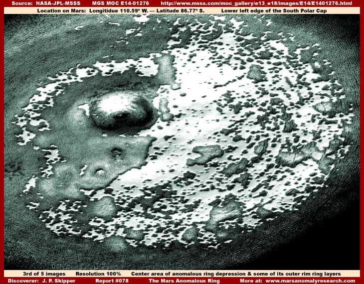
The above third image provides a closer view of the ring's center area as well as just catching a bit of the inside portions of the dark thick outer ring that are a bit lighter in color and do not quite disappear into the mid and outer ring deeper darkness. Here we can now better see the tiny distantly seen grooves and/or ridges that constitute the whole of the dark outer ring. All of these tiny grooves and/or ridges are clearly defying surrounding geological norms by being oriented or having aligned themselves in a round circumference ring shape and incredibly in a great many layers conforming to the shape of the larger ring circumference.
Right off one just has to ask the question why and how can this be? What forces could result in such a isolated feature so physically different than, not only its immediate adjacent South Polar Cap geological environment, but from any other Mars terrain? As the Startreck Spock's character would say, fascinating!
But, that isn't all, note that these tiny ring layers are continued out on what appear to be islands isolated at so many spots on the very light color more reflective broad flat center area surface. It gives the distinct impression that the light color center area may have at one time in the past been a solid mat of these ring layers with subsequent changes at the site resulting in residual portions being left in the form of these islands complete with the same now interrupted groove and/or ridge patterns on them.
Also note that the highly reflective lightest color ground detail around these islands in the broad center area is very smooth and very level where not interrupted by the more elevated island looking forms. This particular feature is typical of a great deal of the surface of the South Polar Cap. I suspect that this is shallow at times liquid and at times frozen surface melt water covered over by image tampering to mimic ice with the intent of course of it being interpreted as CO2 ice and of course not water ice. I see great amounts of this on the Cap in my research.
What is not typical though is the ragged irregular shape of the island form's outer perimeter edges or shorelines seen here within this ring. Most of the great many island forms around on the Cap surface, including in the open environment right outside this ring, are smooth rounded forms similar to that seen in the fifth and last image below in this report.
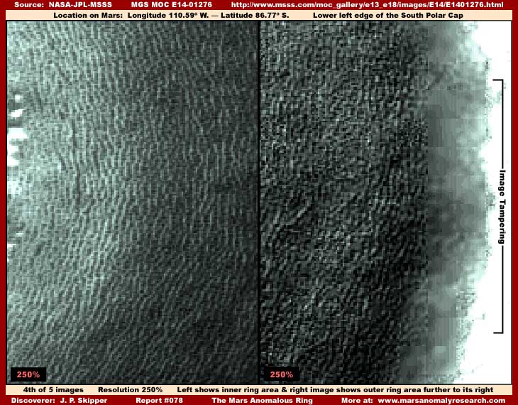
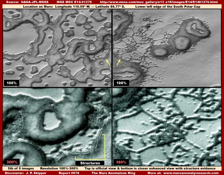
Now in the above fourth image, we skip to a much closer view of a section of the dark ring area directly to the center right in the full ring view image. I have divided it into two adjacent parts because the inside edge in the left view is originally lighter color than deeper into the much darker ring center and the outside edge. To adequately defeat the varying degrees of obscuring dark tint in both areas required different image treatments and therefore the reason for the two split screen images.
As you can see, if you will get your eyes very close to the screen and examine the detail very closely, two things immediately become apparent even in this distant poor quality imaging. The first is that what appeared to be strange previously assumed to be natural origin terrain grooves and/or ridges in the third image, now appear here in this closer view be row upon row of individual geometric darker color structures in many long continuous rows conforming to and creating the look of this round ring circumference. Obviously, these individual geometric forms in their densely packed many tens of thousands are very suggestive of artificiality. If so, even though still strange to us, that may better explain what this may be and perhaps that this ring may have come into existence through artificial rather than natural means.
The second is that the elimination of most of the obscuring darker tint at the ring's outer perimeter as represented by the right split screen image has revealed extensive very obvious image tampering hidden by the darkest tint at the very outer edges of the dark ring and conforming precisely to the ring shape. I can further confirm that this kind of tampering extends all around the ring's outer perimeter edge and the above right image is just a small sample of it. It is logical to presume that this tampering probably obscures larger more readily identifiable geometric structures at the dark ring outer perimeter that the distance and poor resolution could not quite adequately obscure.
The application of such obvious and clearly identifiable image tampering conforming so purposefully and precisely to the ring's outer perimeter as opposed to random occurrence is itself solid hard inescapable visual evidence. It obviously demonstrates secrecy and that there is something here to hide that could not be obscured by cutting resolution and the tiny size that mostly obscures the geometric forms evidence. After all, there is clearly no need for tampering and secrecy applied to natural geology. That in turn logically gives credence to the geometric forms evidence being just what it appears to be.
This is a good point to make the observation that finding any truth in the official satellite imaging science data is most often only a function of capitalizing on mistakes made in the pervasive image tampering. For example, here the choice of using enlarged pixels drastically but effectively cutting resolution within them at the perimeter edge and then depending on a simple dark tint to hide image tampering this obvious was a mistake. After all, an object looking this anomalous could be expected to be examined in very close detail. If general resolution degradation and over pixelation would not adequately hide larger more recognizable evidence, then layers of a artificial semitransparent dark tint could have been overlaid over the natural dark tint of the ring portion of the site sufficiently that it could not be penetrated. This is often done in the satellite imaging. If that tactic had been used here, suspicion would abound but proof of tampering could not be uncovered as is the case here.
The lightening process countermeasures in a graphics software program will work fairly effectively (as you've seen here) on natural dark tint that is part of the original image, such as dark but entirely real shadows, but will not work very well at all on artificially added dark tints subsequently added to a image in coating layers. I learned this very early when they covered things with a dark semitransparent dark tint that I could not look into. For example, although I don't report on it much, rock shadows in the current Spirit and Opportunity Rover ground level imaging on Mars are very often artificially applied dark tint covering many individual objects and hiding something.
In the Mars daylight, all objects are reflective to varying degrees. The tampering covers most of the reflective object with the dark tint leaving just a little of the now unidentifiable reflective edges visible while the bulk of the dark application mimics shadow. Nearby natural objects may also have to be similarly treated, even when there is nothing there to hide, in order to establish and falsify sun angle via the shadow mimicking treatment. One can test and reveal this in a graphics software program. If the shadows do not readily respond to the lightening process, then this is an indicator of artificial application and tampering.
The above fifth and last image here demonstrates two sample sites in the open terrain outside of and above the ring. Each separate site on the left and right is shown in the official 100% view with a closer enhanced view immediately below it.
Note the dramatic difference in the upper official views where nothing in the official view but basic shapes and no real detail can be seen. Even though of poor resolution quality (by intent), it is only in the closer view that one begins to understand what one is really looking at. Likewise it also then becomes apparent just how distant the official view really is providing solid insight into true size scale. That's because image tampering purposefully destroys all familiar frames of size reference forms in the official view leaving only strange unfamiliar forms that provide no familiar size frames of reference and thereby insight. That is intentional and just one part of the overall image tampering obfuscation process.
In the above image on the left, you can see a closer view of the rounded lumpy island type forms in the upper image and the geometric structure evidence in the lower image. The truth is that, in my opinion, the rounded lumpy rolled form look is itself image tampering purposefully creating this illusion by programming design even as it covers and hides evidence. In other words, it is this particular type of tampering application that gives the rounded lumpy rolled form look, not anything natural. It is also sometimes used as a defining narrow dark shaded border around large flat level areas that are almost certainly bodies of liquid water and water ice depending on the seasonal cycle.
Other similar applications, as compared to this softer rounded rolled form look, give a slightly elevated flat top mesa look covering over, joining and flattening groups of geometric structures but with the overall form outline the same generally rounded shape. The flat level light color more reflective areas are I suspect liquid (depending on the seasons) surface water areas covered by a semitransparent combination of blur and smudge. It is how most of the tampering is done in the broad areas on the Cap on the islands and water areas. In other words, just about all the flat level light color Cap terrain areas are carefully covered over as are the island looking terrain masses by direct tampering applications creating these strange looking amorphous rounded island shapes. Then the whole is subjected to this disguising distancing treatment that so degrades detail.
The view on the right in the above fifth image demonstrates the networking type of visual evidence on the Cap that suggests the "ice" concept. When first seen at the normal very distant official resolution, this kind of evidence might remind one of branching ice tracks in a cold environment growing colder where ice branches out as ice crystal structures along track lines. The secrecy agenda no doubt prefers that perception follows this line of thought. However, this evidence is very distantly seen and is much too large in size for that.
As you can see in the blurry closer poorer resolution zoom view, the evidence does not want to resolve into anything suggesting natural geological formations including freezing ice, as one might have anticipated based on the limited official view, but into individual geometric objects in organized if unfamiliar patterns very suggestive of artificiality. Here again, it appears more and more that we may be looking at civilization evidence of some kind just like in the ring. Unfortunately, the resolution providing the view of this evidence is just too poor to go much beyond that.
ANY CONCLUSIONS?
The evidence here is not clear enough to be conclusive about some things and it often raises more questions than it answers. The official visual view of the evidence provides very little decent information to enable any accuracy in interpretation and, in my opinion, that is by design and intent. However, the closer one is able to see the anomalous ring and its immediate environment evidence, the more the evidence that is available moves interpretation steadily away from natural explanations and toward artificiality.
Has someone come along and scooped out a colossal shallow depression in a perfect ring shape in this fairly flat level terrain flood plain and intentionally in a location near seasonally high water levels where it will seasonally flood with shallow liquid water? Water that is teaming with the dark tinted organism and is retained in the deeper than the surrounding terrain system for months after the high water conditions recede and then the retention system is replenished and refreshed in the next high water cycle? Is the organism in the water tiny in size and a food source for higher forms that built the geometric structure evidence and/or is it actually larger in size and itself representative of aquatic or semi-aquatic intelligent life?
Could it be that the outer perimeter of the ring where all the obvious heavy image tampering is at is perhaps hiding necessarily large scale water barrier structure systems at the outer perimeter that control the flow of water into and out of dark ring depression area? I cannot say that any of this is so due to the visual limitations of this evidence. However, I can tell you that I would not be surprised if it was eventually confirmed to be so. A great deal of the civilization evidence that I can confirm on Mars, in my opinion, shows a clear proclivity disposed toward their structures being next to surface water and even standing in surface water.
Above ground open air buildings are often developed in side by side long rows following land slopes. This may not just represent a different ethnic way but a functional solution following surface water flows that are too shallow to be seen in this distant satellite imaging. These civilization centers may be naturally and/or artificially flooded with water around their base areas. The ridge forms in long lines that I've previously reported on, and some keep insisting on identifying as "tubes," are actually associated with and on slopes into drain or catch systems and water flowing down the slope these forms are on. Cliff and crater sides and bases are very often obscured with a sweep type tampering suggesting anomalous evidence presence there where water flow may be expected to be present. I have also long suspected that this proclivity for the presence of shallow water equates to it being their major source of sustenance.
So it would not surprise me to have confirmed at some point that this ring and its massed structure evidence represents someone on Mars fully indulging in a proclivity for liquid surface water to the point of partial and even full immersion in it or under it for extended annual periods. However, unless there are other sites like this around the planet completely hidden under image tampering, it must be remembered that this site appears to be one-of-a-kind unique and therefore not representative of others.
On the other hand, this site may represent exclusivity such as a one-of-a-kind vacation site on a tremendous scale at times temporarily shared by all who may be interested in its experience in rotation around the planet taking advantage of this great South Polar Cap seasonal flood and recede water engine and the unique ecological environment that it provides. As you can see, the more we find out about some particular evidence like this site, the more the questions are raised rather than answers provided.
Do you want to know the truth? I know I certainly do. Further, I am satisfied that many answers are available in the real science data never released that has much clearer closer resolution imaging without the tampering that is so characteristic of this very poor imaging officially released to us. The nature of and the flaws of the image tampering clearly demonstrate this. Someone some where is sitting on this gained information in secrecy that our tax dollars paid for and which is our property and not theirs.
It is no longer a matter of someone doing the National Security thing on our behalf, it has gone beyond that for too long now and now moves more and more toward elitist self serving interests. This science data is not the property of federal agencies, their contractors or some secrecy agenda group of insiders. It is unquestionably the property of the American people who paid for it and are entitled to it. They always have their hands out for the money and we are good enough to provide the financial support but not good enough to share in the knowledge gained from our own property. I have a problem with that concept. Do you?
DOCUMENTATION
http://www.msss.com/mars_images/moc/4_27_00_spcap: This link takes you to the MOC2-225, 27 global South Polar Cap image used as the left split screen image at the top of this report.
http://www.msss.com/moc_gallery/e13_e18/images/E14/E1401276.html: This link takes you to the main E14-01276 and E14-01277 official science data imaging used for all the rest of my report images. This strip was used because it provided slightly better resolution than the other images of this site showing a little more detail. However, please note that this image has been flipped both vertically and horizontally at official level and will require flipping back to the orientation that agrees with that demonstrated by the South Polar Cap ice mass forms.
The following
represent additional images of this anomalous ring site:
M12-01876
..... M13-01814
..... M14-01694
..... E05-02737
..... R13-04339
..... R14-00130
, Investigator
![]()