
MARS SOUTH POLE
SHORELINE TAMPERING
Report 083
February 19, 2005
This report is mostly about image tampering and reinforcing the need to recognize it as well as the need to always take it into consideration when examining and analyzing the official imaging before trying to draw any conclusions from this data. Also, this is a supplement to my previous report #082 titled "Mars Shoreline & Life Evidence" with the evidence here relating directly to that report. So be sure to review that previous report.
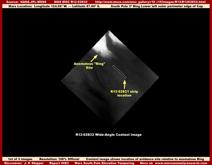
The above first image is the very distant R12-02832 wide-angle context image providing information on a number of things. First, it demonstrates the anomalous "Ring" and how near location wise the evidence in this report is to it. Likewise, the visual location of the narrow-angle R12-02831 strip as shown in the above image demonstrates that this evidence is located in the same place as that in the previous report #082 wide-angle context imaging except that that the strip orientation in this report is more paralleling down the length of the shoreline as opposed to crossing it at right angle. Also, a comparison of the coordinates of the evidence here in this report of Longitude 124.58º W. – Latitude 87.00º S. with that in the previous report #082 also confirms that the evidence in both these reports share the same coordinates location.
Third, there is one glaring difference though. The evidence in the previous report was imaged from September to November during the dryer seasonal cycle at the Mars South Pole as demonstrated by the wide-angle context images presented in that previous report showing no flood water over the main terrain land mass and the terrain form sticks out as a exposed peninsula above any general water levels. However, the above wide-angle image in this report was taken in December during the beginning onset of the seasonal flooding seasonal cycle and the dark areas demonstrate this flooding condition. These flooding cycles and the evidence supporting them can be found in my earlier report #077 titled "Mars South Pole Flood Waters."
In the above first image, you can clearly see that the darker liquid has covered most of the peninsula that the "Ring" site sits on and the liquid is now getting close to the Ring itself in late December. If it is a liquid, that indicates that the shoreline evidence presented in previous report #082 would now be submerged under this flooding liquid just as it appears in the above first image.
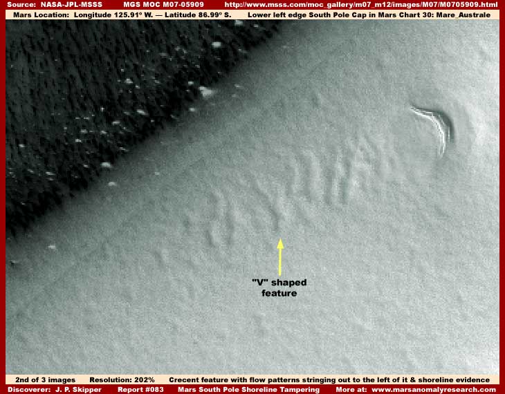
Now the above second image demonstrates a sample of the same shoreline evidence presented in previous report #082. Note again the recognizable crescent shaped feature in the upper right brought to your attention in the previous report for anticipated identification purposes here.
However, here in this report, note that I have visually de-emphasized the focus on the dark pattern life evidence detail and the dual shorelines on the left and more emphasized the focus on the light color terrain detail on the right and particularly the terrain patterns found there to the left of the crescent shaped feature. Of particular importance here is the unique terrain patterns stringing off to our left of of the crescent shaped feature. Take special note of the vague "V" shaped feature pointed out with the yellow arrow for further identification and comparison purposes in the next third image below.
These forms stringing out to the left of the crescent shaped feature are important because they are very typical of flow patterns caused by lowering levels of shallow drain water crossing on and over open terrain ground with a measure of turbulence in it. For example, if we assume seasonal rising and falling water level conditions at this site as indicated in the previous identified reports, dropping water levels draining from our right to left toward the shoreline would encounter the crescent shaped feature. Faster flowing water interrupted by and over and around this crescent feature would cause turbulence in a distinct path down to the left on its lee side. This faster flowing drain water turbulence caused by the presence of the crescent shaped feature interrupting its flow would explain these forms stringing out in a path in the terrain to our left in the path of the turbulence.
Those terrain ground patterns stringing out in a path to the left of the crescent shaped feature and gradually fading out the further away from the crescent they get is a good indicator that shallow drain water flow is present at times at this site. This alone is important evidence of what has been happening here at this location.
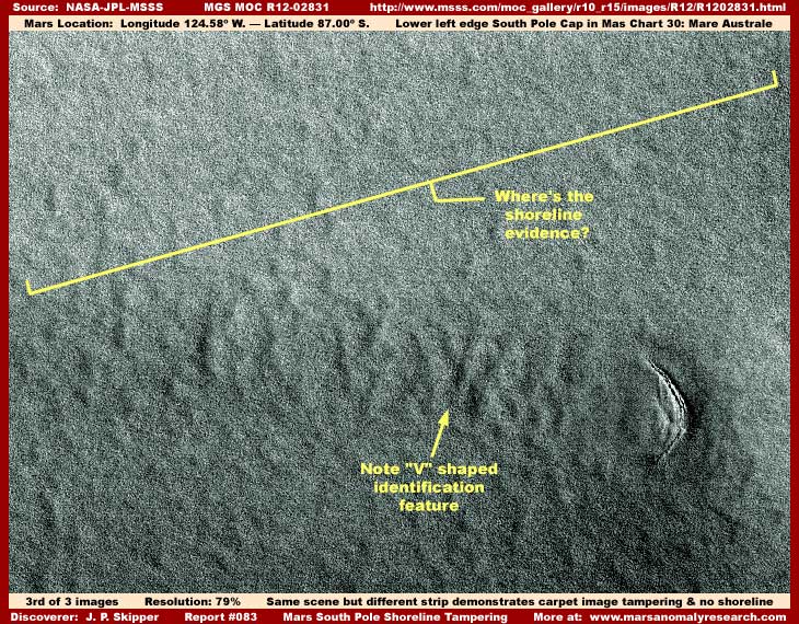
Remember in the first first image in this report demonstrating how the peninsula this site is located on appears to be under a dark liquid? That evidence is in the companion R12-02832 strip that is the wide-angle context image for the R12-02831 strip that is the source of my above third image here of the exact same site taken at the same time. But, where is any water in the above third image? Don't see it, well neither do I. So is that proof that the water isn't present and that I'm just full of "something" unmentionable other than water?
Let's examine this scene with more care. If the location coordinates are not proof enough for you, a careful comparison examination of the "flow" patterns in the terrain in a path to the left of the crescent feature is proof positive that we are looking at the exact same site here in the R12-02831 (3rd) based image as we are in the M07-05909 (2nd) based image. So there should be no confusion about that. But, what happened to the "shoreline" evidence seen in this area in the M07-05909 strip and in so many different strips as linked to in report #082? We know it has to be there because of all those different official strips as previously reported. Also, where's the dark flood water that the companion wide-angle R12-02832 first image above still indicates is there?
Oh it's all there all right, just covered up under this innocent looking but carpeting image tampering that they thought would hide all. Fortunately for us, this is the mapping type carpeting image tampering that maps to terrain contours. If it wasn't, we wouldn't be able to conclusively prove via the "flow pattern" ground evidence that this is exactly the same site. Note to that there are very subtle differences between the crescent shaped feature in my second and third images here. This is due to subtle differences in the image tampering applications in each image and what subtle features were covered up in each and what wasn't. This crescent artificially created slight dissimilarity via the image tampering differences is what makes it necessary to go to a close examination of the "flow pattern" evidence and particularly the "V" shaped evidence for conclusive identification that we are on the same site.
So why cover the site up now in the R12-02831 image and not in the previous reporting evidence imaging? The truth is that what ever real evidence is here on this light color terrain has been thoroughly covered up in all the official imaging, including both the M07-05909 and R12-02831 images, just in different ways and little that is real has ever been visible in any of the global, wide-angle, or narrow-angle imaging of this site. The only reason that we can recognize the image tampering for what it is here at this site in either of these images is the crescent feature prominence left partially out of the tampering as a clue and even more importantly the error of the map type tampering conforming to and revealing under its carpeting treatment the vague ground contours of the flow pattern evidence in a path stringing out to the left of the crescent.
In the very distant global imaging as well as the context wide-angle distant imaging, this area is thoroughly covered up by smooth featureless smudge applications easily identified for what they are. That is, if one examines closely and objectively. The lower peninsula land imaged in this area during the dryer water seasonal cycle in the narrow-angle closer imaging demonstrates a grainy tampering pattern that isn't seen as well in the earlier M07-05909 image with it having a more smooth texture. It has a smoother texture because it is impacted by the distancing tampering technique causing the grainy pattern to blend in with itself and appear smoother at the greater distance. In strip R12-02831 that the above third image is drawn from, the view is somewhat closer and therefore the grainy pattern is more apparent.
I might add at this point that the file size for the above third R12-02831 based image is abnormally very large and, in fact, it is one of the largest that I've presented here on the Web. That's one reason why you don't see many more images in this report as such large graphic file sizes substantially slow down the report's loading time. Such a large file size usually means that the graphics software (industry standard PhotoShop in this case) is seeing a great many pronounced individual hard objects down below the image tampering visual cover. In other words, even though this whole strip is covered over with image tampering and is essentially visually featureless except for the crescent shape object and should of course be of very small file size, the exact opposite is the case as the graphic software is seeing an awful lot of hard object detail down there through and below this covering.
I've learned that the tampering applications can visually fool the human eye but it can't completely remove the original evidence digital signatures and the software sees through the tampering obfuscation in this way when the human eye cannot. That probably in turn logically means considerable densely packed individual structure evidence is present but unseen at this site. On the other hand, in fairness, if the tampering pattern used tiny hard artificial geometric forms to achieve the grainy surface texture look you see in the above third image, it is possible that this could also contribute to the unusually large image file size as well.
Along this line of consideration, in other image strips not visually evidenced here, the view is even closer and these cease to be simple blending suffuse grainy patterns and become tangles of well defined line patterns in the many thousands that can be individually seen. This difference in digital textures, just seen at artificially manipulated different focal distances, is how differences in image tampering appearance and thereby perceived interpretation is economically achieved by those who do not want what ever is below this digital covering tampering to be known outside their circles. It is just one of a great many ways satellite image tampering is done before this data is publicly released.
The dark and clear shoreline in my second M07-05909 based image here has come through this tampering to us and has been partially left out of it for a number of reasons. First, the super dense dark pattern evidence on the left, is probably cultivated giant form fungi of some kind and therefore something not familiar or readily recognizable to us here on Earth and therefore can be left out of the tampering to provide difference in visual textures. Even in the M07-05909 based second image here, the light color fields are also carpeting image tampering. This tampering is not only all across the open terrain but extends beyond the clear demarcation line right up to the edge of the dark pattern evidence helping form the well defined second demarcation line there. I did not bring up this issue in the previous report because I wanted attention to concentrate on the shoreline life evidence and not on image tampering and I knew I would shortly be bringing it up here in this report.
As I have explained many times, the automated tampering software is designed to leave out natural non-geometric objects to provide a little natural detail to break up (disguise) the tampering fields and inhibit their recognition. The white specks or spots in the above second image qualify to be left out and were. The clear demarcation line also qualifies and was also left out, even if visually resolution degraded a bit. Why? Because it is transparent and the software has trouble with that, as I have explained before in earlier reports. Further, the software is operating with larger as well as closer fields of view with higher definition that is never released to us and knows that the clear demarcation line wanders around some in the terrain and does not represent a straight linear line typical of artificial geometric or straight linear forms that suggest artificiality, even if it does appear relatively straight and linear in some of the limited view individual narrow-angle strips such as in my second image above.
As I have said, this automated tampering software is very good and getting better as the years go by but nothing is perfect and mistakes are still made. The fact is that very little of what is seen of Mars' surface is real and most of it is universal image tampering. It is via such a massive tampering process, not only hiding specific anomalous information, but also creating and proliferating terrain illusions that the scientists in general gradually become conditioned to accept that what they are looking at is real. That's because their minds cannot grasp the scope and magnitude of this manipulation, that such illusion would be attempted on such a massive scale, or that they could be so easily fooled by it.
My own success at accumulating so much anomalous evidence out of this sea of official level image tampering lies mostly in recognizing the image tampering up front for what it is, not pretending that it doesn't exist, and capitalizing on the rare mistakes that are made in its application in this planetary imaging. As time goes by and images are viewed in the many tens of thousands and via an open objective attitude, one becomes increasingly familiar with the tampering software and its idiosyncrasies and becomes more efficient at what to look for determining what is real and what is not.
The South Polar region has a great deal of surface water present in its general environs seasonally during certain times of the year either as liquid and/or ice, as I have reported on. Because the evidence of this is wide spread and such evidence is subject to secrecy, that is why the carpeting type image tampering is so thick in this region. Further, its presence is why the carpeting type image tampering eliminated the shoreline evidence seen in so many other images of this same area. The flood water is over this site now in December when the R12-02831 image was taken under this image tampering. Also, where water is so extensively present, then both basic biological life as well as any higher form intelligent life and its structure evidence can be expected to concentrate in this favorable environment and that is another strong reason for so much of this carpeting image tampering.
The fact is, one ignores the image tampering factor at one's peril, if true understanding is the investigator's goal. For example, when I look at a narrow-angle closer view image that demonstrates that it is located in a very dark area as evidenced in the wide-angle context companion image view, I logically expect to see a darker scene in the narrow-angle companion image. When what I actually see is brightly lighted highly reflective terrain conflicting evidence in the closer narrow-angle image, I am immediately suspicious either that this narrow-angle view is not really the one from this area or that the companion wide-angle context image scene has been compromised and doesn't represent anything real, or both. It is simple logic and reason.
Here's another example. I look at a narrow-angle image of the bottom of a crater and I see that it has a companion wide-angle context image with the narrow-angle image's location white outline in it. In the context image, the bottom of the crater is shown inky dark and yet the narrow-angle image is full of light reflective terrain and I know that something is wrong. Worse, the white outline in the context image is sometimes compromised by having the inky dark coloring in the crater bottom intruding all over the outline. This clearly indicates that dark color tampering was introduced into the bottom of the crater in the context image after the white outline was placed in it and thereby crystal clear evidence of subsequent image tampering. Yet, few seem to make this very obvious observation and connection.
The South Polar region is full of this kind of questionable imaging. Further, if that more universal prevalent type of regular tampering isn't bad enough, as one moves closer to any one of the proposed old mission landing sites in the official imaging, the imaging consistently starts degrading even worse to the point of being essentially useless for investigation in a wide area around the site demonstrating a clear image tampering pattern of obfuscation in this regard. Accidental? I don't think so. All this kind of tampering evidence is very obvious as well as common, yet the scientists appear to be unable to recognize any of this. Incredible and frustrating to put it mildly!
SUMMARY POINTS
Tampering Evidence: Basically, the evidence in this report represented by a comparison of this exact same discovery site in the M07-05909 based second and the R12-02831 based third images here clearly demonstrates that complete view blocking carpet type image tampering is going on in the third image. Now you see the significant shoreline evidence in the older second M07-05909 strip based image as well as many other linked to images in report #082 and now you don't at all in the newer third R12-02831 strip based image. The presence of the image tampering in the image before its official release is very straight forward and clear.
Water Flow Evidence: The evidence in this report also indicates drain water flowing over land via the terrain flow pattern evidence stringing out in a path to the left and downstream of the crescent feature. Now that, in of itself, isn't a big deal relative to the considerable and stronger evidence of ancient water drains and erosion already officially reported multiple times indicating the presence of water in past more ancient times. That type of evidence reporting supports the official picture and mantra constantly pounded home that Mars may have once possessed surface water but is now a essentially dry and dead world. The big question is whether the water flow evidence common to both the images presented here under this carpeting image tampering represents ancient or more current water flow?
Past or Present?: When one logically combines the flow evidence presented here with the seasonal changing flood water evidence in previous report #077; the shoreline evidence in previous report #082; the presence of image tampering here in this report clearly hiding something at this site; and the evidence of dark flood water in the companion R12-02832 image, despite the image tampering common to both images, the indication is clearly that this water flow evidence is a event that happens currently, seasonally and annually as lowering high water levels recede off of the land mass as opposed to merely being ancient past evidence. That concept is a very big deal when viewed in relation to what we are being told officially about what is happening on Mars.
What I'm trying to do in this report is to show you that logic and reason processes can still be used to effectively reveal Mars truth even in the face of the carpeting image tampering obfuscating the visuals, if one throws a wider evidence net and if one will correlate all the information. Just objectively consider the evidence and think and judge for yourself.
DOCUMENTATION
http://www.msss.com/moc_gallery/m07_m12/images/M07/M0705909.html: This link takes you to the official M07-05909 science data that is the source of my second image in this report.
http://www.msss.com/moc_gallery/r10_r15/images/R12/R1202831.html: This link takes you to the official M12-02831 science data that is the source for my first and third images in this report. There the official image on the right is the wide-angle more distant view context image presented as my first image above and the official image on the left is the closer view narrow-angle image that is the source of my third image in this report.
, Investigator
![]()