
MARS'
ARAM CHAOS WATER, ETC.
Report #095
October 31,
2005
:
Mars surface water is rarely missed
by the very effective an pervasive image tampering. But, when it is missed,
it's fairly obvious as you will see in the evidence here but sometimes has
other visual issues associated with it that we also need to be at least aware
of in basic. This will help facilitate the beginnings of a bit more in depth
insight into a larger mysterious picture still with more questions than answers.
What you will find in this report is some relatively strong water site discoveries
in a specific location that I've pulled out of my coming book evidence because
it requires a little more elaboration than can be given in the book due to
its associated side issues beyond the scope of just the water itself.
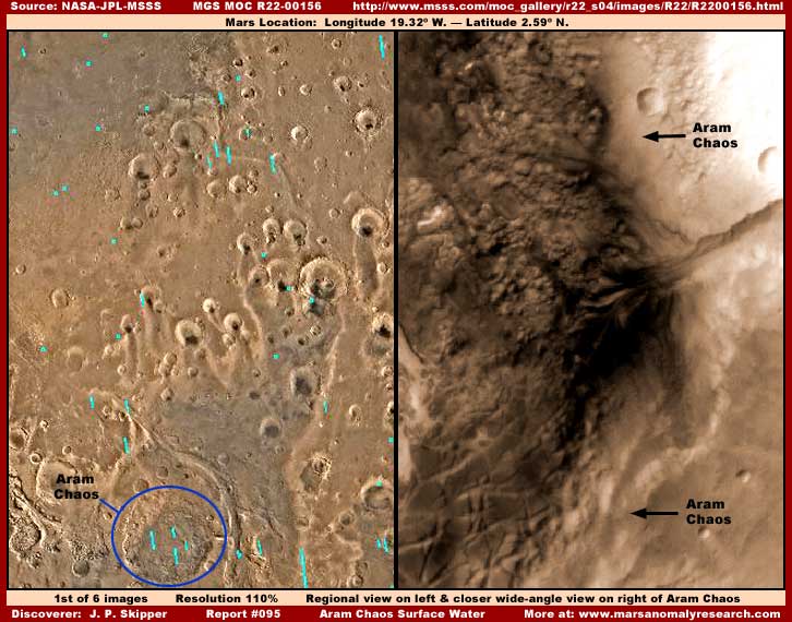
So this report is about an old impact
crater depression officially identified as Aram Chaos
as shown in my above first split screen regional Mars map image on the left
with the blue circle around the crater area. Note the short straight indention
on the right center edge of the blue circle. This is a short east and west
oriented canyon drain system and note that it connects to an old much larger
and broader drain erosion system that extends down from north to south just
to the right of the Aram Chaos area and slightly bending around it officially
identified as Ares Vallis tributary.
At some point in the distant past,
perhaps when more water was still present and flowing down from North to South
in the old longer larger Ares Vallis drain system terrain or before, this
Aram Chaos impact crater suddenly occurred beside it forming a depression
in the terrain. This ancient event no doubt caused north to south flowing
water in the larger drain system to divert for a time into the crater depression
forming the shorter drain connecting to it and perhaps creating full lake
conditions in the crater depression until the surrounding ancient water levels
diminished and flow into the crater slowed down and eventually ceased and
the crater depression started drying out without the water feed over a long
period of time.
The dark color terrain in the bottom
Aram Chaos in the above right split screen image also demonstrates no doubt
why this area is identified as a geological "Chaos." It has a very
rough and uneven floor surface not very typical of often sediment filled older
crater floors. In fact, this Aram Chaos crater depression so close to the
Mars equator is a place of a fair amount of liquid surface water; great long
lines and extensive fields of "ridge forms" (see my Report
#018 titled The
Tubs: Natural Geology or Life? for some insight on this type of evidence)
forming and taking advantage of that surface water; a great many suspicious
visually obscured rounded and oval mounts scattered around like many different
size eggs in the water saturated terrain; and great cracked surface land plates
seen in the bottom of the right split screen image.
All of this different kind of evidence
is too extensive and too complicated in its interpretation to try to go into
in detail here in this shorter reporting style, so the main thrust of this
report will be essentially limited to the most obvious and easiest to identify
primary water evidence with brief forays into the other associated evidence.
Likewise, you should be aware that this is the same specific area from which
my Report #029 titled "Huge
Nozzle Shooting Liquid Spray" was drawn. It demonstrates some of
these obscured suspicious mounts and one possibly in the process of being
constructed or evacuated
implying that these mounts may be associated with a
measure of artificiality suggesting the possibility of underground civilization
evidence.
Also, in my general observational experience
in this satellite imaging, the extensive ridge form evidence is often indicative
of current or at least past ground water saturation conditions. The same with
the rounded oval mount evidence, especially when they are smaller to medium
size and very plentiful as they are at this site. But this mount evidence
forms in the midst of relatively level shallow depression water collection
areas rather than on slopes. Sometimes these mounts are present in massive
huge sizes far larger than demonstrated here where surface water is no longer
observationally present or it just may be too obscured by the ever prevalent
image tampering. So there is apparently a growth in central size element to
this suspicious mount evidence just as it is with the ridge form evidence
as they spread in great numbers laterally over wide down grade surface areas
and very often in lines along canyon slopes.
Of course they may just be some strange,
unusual and unfamiliar looking geological mount formations on another world
to. But, that huge nozzle shooting a heavy liquid spray evidence in my Report
#029 suggests there is more to this mount evidence than meets the eye with
potential possibilities worth closer consideration.
Both of these types of evidence are
also physically very durable and continue to survive in the terrain long after
the passing of the surface ground water conditions that apparently originally
facilitated their existence and may still support them via unseen underground
water conditions. So their presence here doesn't necessarily mean that surface
ground water is currently present that can be seen in this visual satellite
imaging. However, knowing the relationship between ground surface water and
the ridge form and mount evidence as briefly described here, I always look
for depression catch water systems in the terrain where this type of evidence
is located that might still reveal the presence of surface water in the low
places.
Unfortunately, most of the time, these
catch systems are effectively covered over by image tampering hiding it. Sometimes
the tampering applications are light to medium color but often they are dark
color that still tends to look like dark water contrasting sharply with the
surrounding land terrain because it is of the darker color matching mapping
kind that tends to replicate and mimic the original water's darker color including
even its shorelines. Most of the time researchers who declare that they have
identified and found surface water on Mars are only identifying this false
image tampering application overlay evidence. Now don't get me wrong, the
water may still be there and the presence of the tampering even tends to confirm
that this is may be the case, but it's just that the visual evidence of it
is compromised. In my reporting I try not to report such evidence as genuine
water unless I'm confident that we are visually looking at the real thing
and there is other supporting evidence.
One can always tell when these applications
are image tampering because, unlike true water and true shadow, the dark areas
of image tampering have zero transparency factor to them. Further, as an application
artificially applied on the natural real terrain topography to cover it after
the fact in processing the data downstream, the dark tampering area will not
respond to image lightening as will the true shadowy water depths with the
essential natural transparency factor. Finally, introducing excessive contrast
will reveal the definite dithering patterns of the tampering application itself.
Understanding to a greater at least
basic extent all of the evidence here and its interdependent relationship
with each other as briefly described above and below will result in deeper
insight into all this particular type of evidence on Mars rather than just
considering the more obvious surface water collection systems evidence alone.
Basic understanding of this interdependent relationship is very important
even if the true deeper meaning of the ridge form and suspicious mount evidence
is not yet fully or adequately revealed. I am reasonably satisfied that both
represent growing expanding dynamic life of some kind, including possibly
civilized life, but being conclusive on this will have to wait on better visual
evidence.
So, with this
information background in mind, the following evidence and its interdependency
is presented:
(1) The lowest depression water dark catch systems where down slope flowing
water collects in deeper open pools.
(2) Plentiful ridge form evidence taking advantage of unseen shallow water
running down terrain grades or slopes.
(3) Suspicious mounts taking advantage of shallow water pool catch systems
in water saturated more level ground.
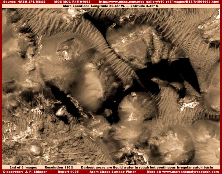
The larger darkest areas in the above
second image area (drawn from the MGS MOC R15-01663 science data strip) in
Aram Chaos is liquid surface water seen here in an extensive irregular depression
catch basin system of pooling open water. The "ridge form" evidence
seen here is often formed and present where substantial sustained shallow
water flow over time down a grade or slope is or has been present. The resolution
is far too poor and distant here to be able to seen any of the shallow flowing
water evidence but its resulting collection in these catch basins in deeper
pools is evidence on a much larger scale and therefore more readily seen.
The diffuse roughly roundish or oval
areas are some evidence of the suspicious elevated mounts mentioned in the
preceding narrative. They are usually always characterized by a obscuring
fuzzy diffuse visual quality radiating out from a central core but with a
identifiable perimeter edge and this is overall definitely not typical of
true natural terrain mounts. But it is hard to determine with any accuracy
whether what we are looking at something obscured by true diffuse terrain
level (possibly artificial?) surfaces or whether these objects are merely
obscured by image tampering applications. Certainly some of the fuzzy diffuse
quality is image tampering but it is hard to make enough distinction as to
what is what and to what degree.
On the other hand, the giant nozzle
shooting liquid spray in my Report #029 is telling evidence in this same specific
area that cannot be ignored. That evidence suggests artificiality may be involved
here in this location and associated with the mount evidence. So I strongly
suspect that the mounts do represent perhaps real camouflaged by design to
look like geology civilization evidence but can't say for sure because of
the very effective visual obscuring effect. Even so, I've come to the conclusion
that it is time to present this evidence and this possibility, at least in
its basic form.
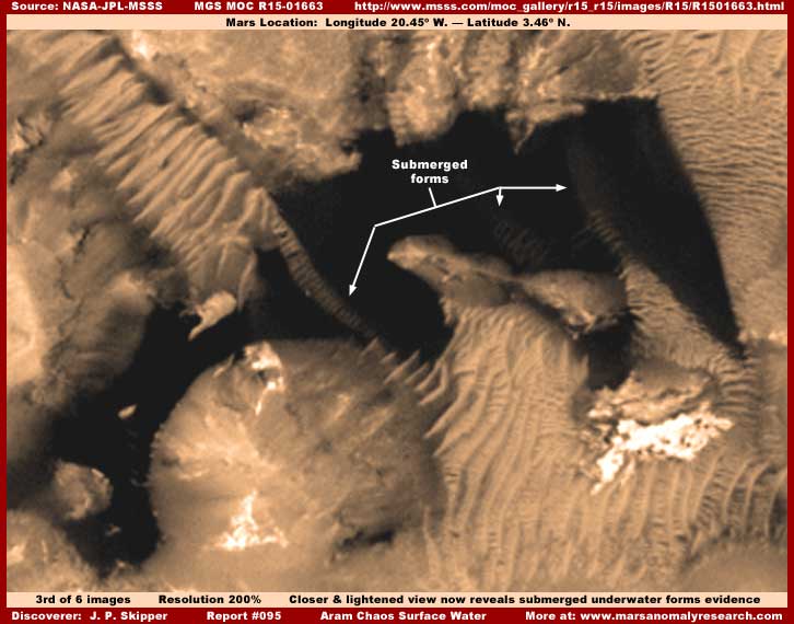
The above third image is just a closer
view of a portion of the same water site in the previous R15-01663 based second
image. However, here I've lightened the image just a little to reveal the
presence of the above water ridge form lines extending out into and submerged
under the water surface and note how these forms are partially visually obscured
by the intervening liquid medium that covers them. Such sites are very often
officially identified as collections of dark sand in depressions but such
a explanation is just incredibly lame. Dark sand with the kind transparency
as demonstrated here with submerged forms revealed!? I don't think so.
This transparency factor clearly demonstrates
that the dark area is a true liquid surface with previously above water but
now submerged ridge forms clearly demonstrated partially obscured and visually
subdued below that surface. Now true shadow also has a transparency factor
but, as you can see, there is nothing here to cast shadow into this very irregular
depression. Likewise, note that the total dark area as a whole catch basin
has a clearly seen level waterline effect on all the lighter color terrain
surrounding it clearly demonstrating that it has a self leveling liquid surface
and shoreline and not some kind of shadow.
It should be noted here that, by my
accumulated observations over many thousands of images, fully developed ridge
forms definitely appear to be an above water evidence phenomena on Mars and
are not normally formed fully submerged in water. Therefore, a portion of
them underwater here at this particular site also reveals to us that the water
levels at this site are not static but fluctuate some over longer periods
of time. In other words, the information we do have here tell us that this
site appears to on occasion experience rising water conditions as well as
perhaps longer term lowering water levels.
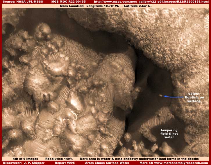
The above fourth image is drawn from
a different R22-00155 image strip and another sample of liquid surface water
site in Aram Chaos. This water was darker in the original science data image
but I have lightened it here a bit for presentation to demonstrate its transparency
factor and to reveal the clearly seen depth and bottom contour qualities.
Note how these land forms and their contours are faintly but clearly seen
below the liquid surface and in the water depths. Further, these bottom contours
can clearly be seen to be underwater extensions of the base areas of the above
water high reflectivity land forms.
Note to that the ridge forms here
at this site, unlike in the above second and third images, extend down to
the water line but not submerged underwater. This is very typical of ridge
form evidence at most such water collection sites. This information tells
us that the water level here at this depression catch system site has probably
been fairly stable over a long period of time.
Note to the tampering field I've labeled
in the lower right corner of the above fourth image. It's not the only one
here but it is the largest and most obvious. How do I know that this is tampering
and not water even though it looks almost the same? Because, despite its fairly
decent matching dark color, not only does this area have no transparency qualities
at all as does the true water area located above it, it will not respond to
lightening manipulation of the image as does the other true water dark areas.
That digital graphic behavior identifies it clearly as an artificial application
subsequently introduced into the image and without any transparency factor
to hide something specific there.
I could have lightened the image more
to reveal more of the underwater bottom shapes but I also wanted you to see
adequate detail of the lighter color many relatively smooth surface elevated
mount terrain forms and the ridge form evidence scattered all over this image
that would have otherwise been washed out detail wise with too much lightening.
There are also a lot more of this evidence at this site not seen here in my
imaging. You should be aware that what ever this kind of mount and ridge form
evidence really is, it flourishes in very shallow water saturated terrain
apparently necessary to its creation and existence and probably represents
life that we just cannot adequately see and identify in this distant limited
resolution imaging as released to the public.
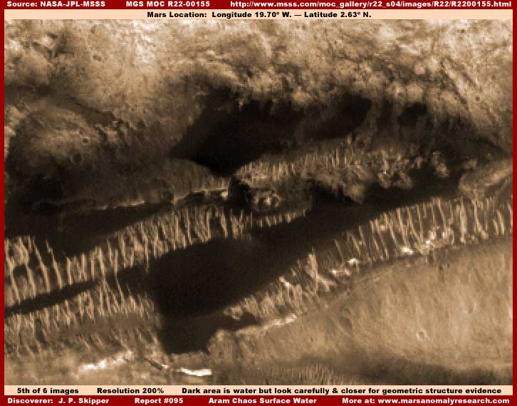
The above fifth image represents another
site a little lower down in this same R22-00155 image strip. However, although
I'm satisfied that some of this darker color includes true surface water,
much of the dark area is actually dark smudge image tampering blotting something
here and sharply cutting off many of the ridge forms falsely mimicking a water
shoreline.
More interestingly,, you will see
that what may appear at first to be a lot of parallel ridge form evidence
left out of the dark tampering applications. But, if you will get close to
the screen and examine this image very close
and carefully, this evidence actually wants to
resolve into tiny very distantly seen geometric tower structure evidence.
Just thought you might be interested in seeing this.
I suspect that the dark image tampering
areas hide the more pronounced larger scale geometric structure evidence leaving
the smaller scale rest of it out because it is so tiny and at the edge of
resolution. Also, the lighter color relatively smooth area in the lower right
portion of the image is also extensive smudge image tampering covering over
and blotting out something extensive there.
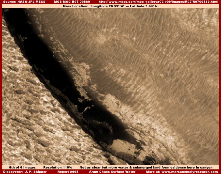
The above sixth image water site evidence
is from another different R07-00889 image strip within Aram Chaos. It is too
distant and too fuzzy to be seeing very much and not the best evidence but
the water is still reasonably clearly seen because of its sheer size and dark
contrasting color. The original science data image dark area was darker than
here but I've lightened the image here to reveal some evidence of submerged
forms as well as the transparency quality over the original darker image.
As for the terrain to the immediate
right (upper) and left (lower) on either side of this canyon catch system
water site, I am suspicious of both these visual fields. I am suspicious that
the left terrain is a completely false graphic because of its sharpness relative
to the right terrain that has been severally resolution degraded. On the other
hand, the extensive field of ridge forms so poorly seen on the right would
be consistent with a wide terrain grade down into this canyon catch system
and are likely at least in basic legitimate even if poorly seen.
SUMMARY
I suspect that water poured into this
Aram Chaos depression over a very long period of time saturating it and the
subterranean ground systems under it with water. Then came along the current
general long lasting dry period producing the remnants of an old very rough
uneven lake bed bottom where shallow water still flows down elevated uneven
portions of the chaotic terrain accumulating in the lowest catch basin areas
you seen here. The cracked plate evidence seen in my first image in the right
split screen in the southern part of Aram Chaos is probably washed in and
compacted bottom old lake bed sediment collections in more elevated terrain
there that has eventually drained dry into the lower areas and the sediment
has cracked like great dry mud flats in the process.
The older more ancient ecology was
no doubt one of a lake in this crater depression. The more recent ecology
then is one of a gradually drying old lake bed with diminishing shallow water
flowing down many elevated slopes and grades in this generally rough uneven
terrain accumulating in the bottom lowest depression catch basin areas. I
suspect that some kind of life as represented by the ridge form evidence has
followed the receding shallow water flows spreading down the slopes and grades
in this shrinking water environment. The orientation of the ridge form evidence
many parallel ridges identifies the direction of the shallow water flow down
between the ridges as what ever life this represents attempts to follow and
husband this gradually diminishing natural resource.
The accumulative evidence that I've
seen indicates that the suspicious rounded and oval mounts possibly represents
at least indirectly different life equally dependent on this surface water
resource but which adopted a different survival strategy. They do not locate
on slopes or grades but in more level terrain shallow water pools or where
the ground is extra water saturated for a sustained period and then form these
large elevated forms. Their plentiful numbers here in Aram Chaos but smaller
size relative to some that I've seen may suggest that the shrinking water
conditions in Aram Chaos is a relatively more recent phenomena as opposed
to a even more ancient scenario and may have generally slowed and stabilized
over a fairly long period of time to what we now observe.
If what we are seeing of these elevated
mounts in this poor resolution imaging as released to us is mostly real visual
evidence as opposed to evidence mostly obscured and/or created by image tampering,
then we may be looking at camouflaged fortified elevated but partially underground
civilization places. The nozzle shooting spray evidence in Report #029 suggests
that there may be artificiality and possibly advanced technology associated
with this mount evidence capable of not only capitalizing on this ground water
rich environment but influencing and modifying this environment through technology
as well.
Sometimes the size of the ridge form
evidence is just barely large enough to occasionally resolve into lines of
individual tall geometric tower structure evidence also suggesting artificiality
as you see suggested here in my fifth image. However, by far, the great bulk
of the ridge form evidence seen all over Mars is smoothed and merged together
into continuous parallel forms. Now this could easily be due to routine general
distance and resolution tampering well evidenced in this satellite imaging.
Could this poorly seen evidence reported on here so associated with ground
water conditions actually be, not only dynamically changing and expanding
life evidence of some kind, but perhaps different forms of civilization evidence
as well? I don't have any conclusive answers on this but, let me put it this
way, I am very suspicious that this may be the case.
If so and there are actually extensive
civilization populations on Mars, it may seem strange at first blush that
so many of them appear to be so focused on water on such a generally arid
planet to the point of even getting in the water that is left with their developments.
On the other hand, if these populations have historically been part of this
drying planetary reality for a very long time and have a historical memory
base of more water plentiful times, it may be understandable that they may
a bit compulsively try to preserve as much as possible a current semblance
of the older loved conditions. Of course there may be other reasons as well.
Now if we had available to us the genuine
satellite imaging science data at the true closer resolution factors and without
all the image tampering, these questions and issues could be much better resolved
so that we could get on to deeper insights. But, until that time comes, it's
our lot to struggle with ignorance while the true higher resolution data and
the real knowledge and insight is reserved for a select few that so readily
take our money for their own covert purposes.
Sorry, but I couldn't help myself
on that little jab. It's just very frustrating trying to obtain a little obscure
truth just on the edge of perception on such a important subject in such tiny
bits and pieces here and there from this sanitized messy poor quality satellite
imaging we in the public are supplied with.
DOCUMENTATION
http://www.msss.com/moc_gallery/m13_m18/mc11.html:
This link takes you to Mars Chart 11: Oxia Palus
that my left split screen image in my first report image was drawn from. The
Aram Chaos site is located at the bottom center of the chart right at the
equator.
http://www.msss.com/moc_gallery/r22_s04/images/R22/R2200155.html:
This link takes you to both the R22-00156 wide-angle
science data image that my first right split screen report image was drawn
from. The companion R22-00155 narrow-angle image
at the same link is the one my fourth and fifth report images are drawn from
and the water site I used here is about a third of the way are a little less
down this strip.
http://www.msss.com/moc_gallery/r10_r15/images/R15/R1501663.html:
This link takes you to the R15-01663 narrow-angle
science data image that my second and third report images are drawn from.
There are other lesser sites but the two water sites that I used here are
located in the middle third of this long strip.
http://www.msss.com/moc_gallery/r03_r09/images/R07/R0700889.html:
This link takes you to the R07-00889 narrow-angle
science data image that my sixth report image was drawn from. The water site
is down at the very bottom of this long image strip.
, Investigator
