
MARS STRANGE LINE NETWORKS
Part-2
Report #108
October 4, 2006
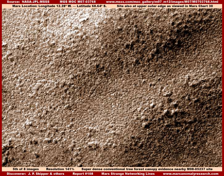
The above fifth image is sourced from another different M07-03768 strip. I don't have enough image size room here to include a reference image on the site's location but fortunately this site is located quite nearby the M08-05237 site evidence reported on in Part-1. Both are located within about a half an inch of the outer edge of the Mars South Polar Region as viewed in Mars Chart 30. In the chart and from the South Polar Cap one moves directly upward to within 1/2-3/4 inch of the region outer edge and then slightly over to the left about 1/2-3/4 inch.
As many of you are probably beginning to realize from growing experience with my previous reports on Mars conventional forest evidence (see especially Report #100 titled "Mars Conventional Tree Evidence"), the above scene from one side edge of the strip to the other is of a super dense conventional tree forest canopy as seen from above in gently undulating terrain. The great bulk of the many official images of this area are very heavily compromised and useless as to determining truth but this one strip, although still resolution limited preventing a much closer examination, is just good enough to reveal some real truth. The whole strip is just like this from side to side and top to bottom and this carpeting kind of massive virgin forest canopy evidence just doesn't get any more obvious than this in this MGS MOC imaging, at least in the poor quality as it has been released to us.
I've included an image of this forest only evidence here just to demonstrate that the nearby M08-05237 forest evidence in Part-1 isn't some kind of odd visual fluke but part of a entire regional area. I must tell you that a vast huge area as seen above the South Polar Cap in Mars Chart 30 and to the left and right of that is full of this kind of massive super dense forest evidence engulfing and covering everything. That of course is why the official imaging of this vast area is so bad and full of so much tampering obscuring it. This area is full of relatively lower level flat top elevated plateaus broken up all over the place by relatively shallow wide depressions, with both the higher and lower elevations very suitable to and covered by this type of forest growth.
By far the bulk of this evidence has been hidden below carpeting image tampering destroying its most obvious detail but the above fifth image escaped some of this providing us with a little real insight. That is the way it is in this obfuscated satellite imaging where only once in a while with rarity does a strip come through to us where we can see something real in it.
Whether you can accept that the bright light color line evidence presented in Part-1 represents life or not, this super dense and vast tree canopy evidence alone speaks volumes for itself and for relatively conventional vegetation life on Mars. Does anything down there look like barren dead world geological terrain to you? It certainly appears to generally be the same conventional type of vast forest canopy evidence that here on Earth serves as a tremendous oxygen pump into our atmosphere. Do you think it is doing any different on Mars? What does this tell you about the officially promoted position that Mars is dry barren world devoid of life and with a very deadly to life as we know it by many times over primarily CO2 atmosphere?
Not only does it appear like the official theorizing passed off as the gospel is wrong, it appears that raw instrument data itself is fundamentally faulty. If so, that turns up side down everything we thought we knew about Mars. That's the wonderful thing about hard visual evidence. Those that we've trusted for so long tell us one thing about how to think and perceive but just too much of the evidence drawn right from their own science data tells a very obvious considerably different story. The question is, are you going to believe what you're told to believe or believe what your own eyes can see and verify in this science data as demonstrated above?
In the above fifth image, if you only see barren geology down there, then there is nothing that I or this evidence record can do for you. Apparently, if the glove doesn't fit, then you must forget! This evidence isn't for everyone. However, if you can clearly see that there is no natural terrain geology visible down there at all simply because it has all clearly been covered over and hidden by something else blanketing over it block the view of it that clearly isn't geology (rocks & dirt), then you can think for yourself and you're the one this growing evidence record is for.
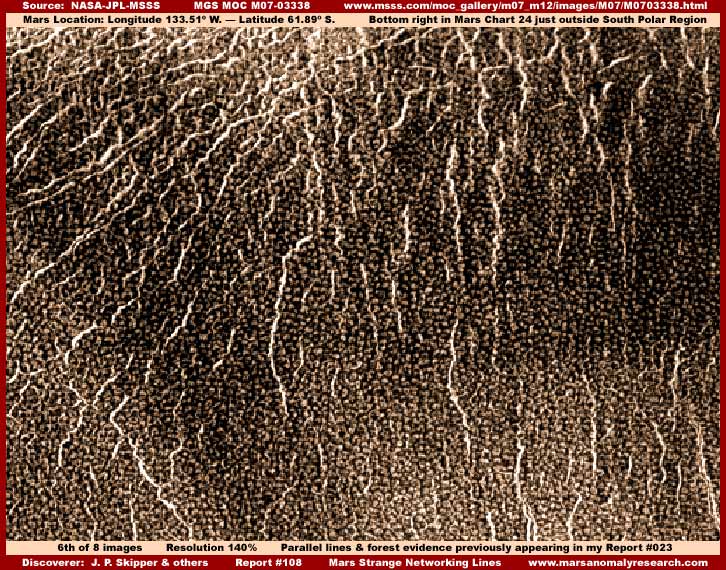
Now the above sixth and next seventh image below are from a different M07-03338 strip of a site located just outside the South Polar Region in the lower right quadrant of Mars Chart 24 about 1/2" up from the bottom where it borders on the South Polar Region. It's in the middle of what looks in the chart to be a smoother area but this appearance is mostly a function of smudge image tampering applications, not real, and cannot be trusted. In fact, this above sixth and below seventh image is pertinent evidence resurrected again from my older 2001 Report #023 titled "Forests of Life on Mars."
The above sixth image scene is of a interior downward slope of an older impact crater. The down slope direction is down toward the bottom of the image and up slope toward the crater rim is toward the top of the image. As you can see, both the line and dense forest evidence are both present with the line evidence being in a roughly parallel to each other configurations and generally directionally extending down slope. As I indicated in Part-1, the forest tree evidence here is slightly less dense and packed than in the forest evidence only in the fifth image and trees are seen as individual uniformly spaced apart objects rather than packed tightly together in dense tight patterns so typical of old flourishing tree growth forest canopy.
Unless one becomes familiar with many hundreds of images of this evidence, it is understandable how such a scene can be confused with building structures because of the more individual quality of the multitude of objects down there. The presence of the line evidence in considerable but not in massive numbers (as seen above) seems to correlate with this kind of forest appearance. It suggests that this forest may be trimmed, groomed or cultivated in some manner. Of course this may also be in part due to a slightly closer view in this particular strip to with less image tampering and so it is difficult to make such distinctions with accuracy. Also, it is of course possible to that the trees here are simply of a different more tightly compact specie providing this visual appearance.
The further up slope the view goes, the thicker the line evidence gets merging into a very dense tangle barrier near the crater inside top rim as is partially demonstrated in the next image below from the same strip.
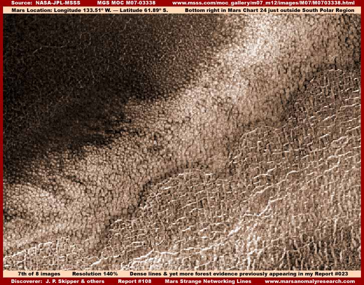
The center light color evidence angling across from the image lower left corner to the upper right corner is obviously light color densely packed relatively conventional forest tree canopy life right on the top rim of the crater at the highest elevation. The super densely packed darker forest canopy evidence on the upper left is going down the outer slope of the crater extending out into the wider terrain.
However, note that the very dense light color line evidence just on the upper interior slope of the crater in the lower right of the image tends to be oriented 90º in very dense tangles across the down slope rather than down it. This may suggest that the line evidence is establishing a stronger barrier, probably counter to and slowing water flow as well as blocking intrusion of the more virgin aggressive densely packed forest on the upper left on the outside of the crater without much of any line evidence in it. Again here is demonstrated the principle of adaptation to conditions providing solutions and this is typical of at least a measure of intelligence.
For a wide area context perspective of this evidence site, go to this M07-03338 link and have a look especially at the wide-angle regional M07-3339 context view there on the right for the implications of how extensive this forest evidence probably is in this region. In the lower right corner of my above seventh image, note also the just beginning of the line evidence's orientation now turning down the crater interior slope that you saw full blown in the previous sixth image.
So the sixth and seventh images above of sites in a different locale other than in Part-1 and just outside the South Polar Region demonstrate both the line evidence and the massive conventional forest evidence presence and its implications. This evidence and its implications seriously undermines the perception of Mars as has been officially promoted and its accuracy. Further, it brings into serious question even the most basic instrument data such a temperature and CO2 atmospheric content so basic to scientific thinking and science computer modeling. In other words, could it be that someone may be peeing down our collective collars and trying to convince us that it is raining? How do you feel about that?
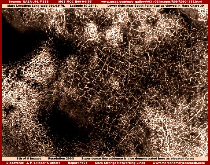
The above eighth and last image here from the different R09-04155 strip provides a bit closer view of what appears at first to be some more line evidence, but it is much more than that. Note the super dense bright light reflective line evidence accumulations to the lower left and right of the darker center area that seem to pile up on each other in a super dense tangle and are oriented in many different directions.
At first glance it appears to be the same type of "line" evidence as previously presented but here gone amok to extremes piling up on top of itself in great density. True line evidence can do this forming tighter and tighter interconnecting patterns until all but its own presence is squeezed out leaving nothing but such dense tangles. That may in part be the case here but I've thrown this image in mostly for its differences rather than for it similarity to the true line evidence.
Note the darker area in the middle of the image with the 90º right angle networking light color narrow grid lines and look very closely and carefully at the darker objects within these grids. These look very suspiciously just like tall buildings rather than trees. In fact, the light color grid lines themselves appear to consist mostly of the flat reflective tops of equal height tall structures resulting in the line grid appearance. This level of clarity, even though still distant and poor, is the result of both a little better ability to zoom in to 200% in this particular strip and rotating the strip 90º to achieve this slightly better perspective on the targeted distant evidence.
Take note that forest evidence does not appear to be present in this scene as it is in the others. That makes this evidence unique and different. The truth is that the above image from the R09-04155 strip does not show any real evidence of forest evidence anywhere in it. Some of the darkest areas such as you see in the above eighth image may be dark image tampering applications or perhaps some other kind of very dark light absorbing growth that may even be a blight or corruption of some kind. Who knows but it may be possible that what we are looking at here is an area of this line evidence where it has flourished too much over time pushing out its natural local resources to the point that it is weakened and opportunistic civilization life is moving in on it?
I've included this eighth image here to demonstrate that this kind of evidence isn't simple and has complexities connected with it that require closer careful examination. So you see, there are still many more questions that need answering about this "line" evidence that are not going to be forthcoming unless we can happen across a strip that allows a closer look at it. However, getting back to the true "line" evidence previously presented, I am going to stick my neck out more than I usually do and offer some speculation on it as follows.
First, I am satisfied that the line evidence is not something lying level with the terrain like reflective water or road evidence. I do believe that the line evidence represents some kind of narrow formations elevated in the terrain that can both act as barriers to water flow or channel and direct it or act as a check to the intrusion of aggressive forest growth. It may well turn out to be that the formations are fairly conventional building structures as suggested in the middle grid area of the above eighth image but I suspect that is not normally the case. If those are tall buildings structures as they appear to be in the above eighth image, I suspect that they represent some other unrelated, entirely different, and more technologically advanced civilization presence.
I suspect that the true line evidence flourishes in forest settings that are themselves taking advantage of plentiful shallow ground water conditions that cannot be visually seen beneath the dense forest canopy. It is the plentiful ground water that is the primary attraction for them rather than just the presence of the trees. I suspect that the line evidence's elevated formations can either serve to block or inhibit water flow in some conditions and in other conditions serve to direct and channel the water flow as well as retard tree forest growth. I suspect that at least partial immersion in shallow water is essential to the line evidence's life cycle.
Now, taking my neck sticking out a step further, I suspect that these are in general the same type of elevated "ridge form" formations that I've previously reported on in my very first Report #001 titled "The Real Smoking Gun as to Life on Mars" and Report #018 titled "The Tubes: Natural Geology or Life." They look so different in that kind of earlier reported evidence only because they are located on normally short slopes in generally less hospitable terrain taking advantage of sunlight and shallow water flowing down those slopes and do so without the presence of trees. Because of these different terrain conditions they need only appear in side by side in parallel channeling configurations and usually on shorter slopes giving them that extended long line corrugated or segmented "tube" or "worm" appearance concept so promoted by others.
In other words, forests are not critical to their presence, only the appropriate shallow ground surface water conditions and sunlight. The difference in appearance of the "line" evidence in this Report #108 and the "ridge form" evidence in Reports #001 and #018 is mostly a function of the type of shallow water terrain environment that they must adapt to. Some of those terrain environment's water presence are favorable to dense tree forest growth as in this Report #108 while other environments such as in Reports #001 and #018 are not.
Also, it should be noted that, regardless of the need of shallow water presence, this "line" or "ridge form" life evidence does not do well in deeper pooling water conditions at all but does seem to do well in some circumstances on water ice where seasonal warming trends create temporary melt and shallow water flow conditions consistently over time. It can for example often be seen in the Mars imaging forming its parallel ridges on water ice masses at the bottom of craters and at the base area of elevated water ice masses.
I have also seen this evidence in interconnecting grid networks where it has attempted to trap and hold melt water in shallow water level conditions but usually doesn't do well at this for very long because the melt water conditions are not stable and consistent over time. When this happens, it tends to loose is opaque light reflective quality appearing dull and more like natural geology which may represent death. All of this diversity is just too much and too time and space consuming to try to encompass here in this shorter reporting style and so I'm not even going to attempt to go there.
I suspect that this life form is a living organism that builds elevated narrow ribbon formations located partially in shallow water that it in turn lives within or under. The formation may be made of minerals and opaque collecting and reflecting essential solar light. When this evidence appears in heavily forested conditions, the narrow ribbons of elevated formations have to be tall enough to get above the tree height in order to catch sufficient solar light. When in level depression systems, the line evidence tends to be in interconnecting network formations trapping water proliferating in increasing denser networks over developmental time depending on stable water conditions. When on the slopes between elevated terrain and lowland areas, the line evidence tends to be in parallel formations down the slopes along the slope orientation where shallow water flows downhill.
Sometimes the ribbon formations are used as barriers to inhibit too rapid escaping water flow or redirect it and/or to retard intrusion into their territory by aggressive virgin forest growth. Of course this is speculation but based on deductive reasoning in turn based on poor visual evidence and I might be well off of the mark here to. But, you can also bet that I would not be indulging in such speculation if I didn't have at least some confidence in the truth of it. We'll hopefully learn more of this as time goes by and perhaps better imaging becomes available.
The bottom line though is that the conventional forest life evidence seen here is alone very obvious, very strong, and not to be ignored or denied. The presence of so much massive relatively conventional tree evidence on Mars is astounding to us relative to what we have previously been led to believe and has the potential to alter completely not only how we Earth populations perceive Mars itself but also what may be on other planetary bodies around us that may suffer from similar information and perception inaccuracies. As for the line evidence, there is no question in my mind that it represents life of some kind even if we may not know conclusively exactly what kind of life it is.
Another bottom line conclusion is that none of this visual evidence can even remotely be confused with natural planet geology and such anomalous evidence steadily and relentlessly chips away at the official position that Mars is a dry, dead, barren world hostile to life as we know it. As this kind of revolutionary hard visual evidence stacks up, the sheer weight of it must eventually change even some of the most closed minds and serve as a growing irritating thorn in the side of the secrecy agenda.
DOCUMENTATION
http://www.msss.com/moc_gallery/m07_m12/images/M07/M0703768.html: This link takes you to the M07-03768 official science data image strip that my above fifth image evidence is drawn from. Note that if you use the third listed straight .GIF strip as I did, it has been flipped both vertically and horizontally at official level and will have to be flipped back to the correct orientation confirmed by the first and second listed strips in this set and to agree with my image's orientation.
http://www.msss.com/moc_gallery/m07_m12/images/M07/M0703338.html: This link takes you to the M07-03338 official science data image strip that my above sixth and seventh image evidence is drawn from. Note that if you use the third listed straight .GIF strip as I did, it has been flipped both vertically and horizontally at official level and will have to be flipped back to the correct orientation confirmed by the first and second listed strips in this set and to agree with my image's orientation.
http://www.msss.com/moc_gallery/r03_r09/images/R09/R0904155.html: This link takes you to the R09-04155 official science data image strip that my above eighth image evidence is drawn from. Note that I used the third listed straight .GIF strip but rotated it 90º counter clockwise to achieve better perspective on the grid and building structure evidence.
http://www.msss.com/moc_gallery/m07_m12/images/M08/M0805725.html: This link takes you to the M08-05725 official science data strip. Its evidence does not appear here in this report but nonetheless it will show you more of the line evidence and more of the forest evidence and it to is nearby the evidence presented in Part-1 of this report. Additionally, this strip will also better show examples of the multiple elevated plateaus broken up by wide shallow depressions typical of this region referred to here in narrative portion of this report.
, Investigator
![]()