
MARS KAISER CRATER
WATER & LIFE: Part 1
Report #112
December 29, 2006
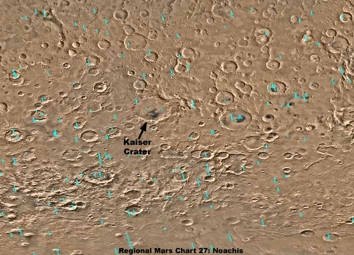
The above first image is a very wide area map of the southern hemisphere Noachis region on Mars with Kaiser Crater's locale pointed out with black arrow. The southern limit of this region borders on the South Polar Region northern limit and Kaiser Crater is the source of the evidence seen here in this report.
Note the distinctive dark shape in the center floor area of the crater and then note that other craters also have dark shapes to varying degrees. One might speculate that the dark areas are often signs of water presence in the bottom of these craters but, for the most part, these dark areas are always one by one explained away officially and visually as geological dark sediment or sand dunes and never water and never anything else that might spark mystery or interest. In some cases they really are the simple explanation of dark sediment dunes as truth is often weaved in with misdirection.
However, sometimes the dunes are also something else that mimics the dune look in the midst of real dunes. Likewise, they are sometimes false artificial creations designed to mimic the non threatening (from the secrecy point of view) geological dune look while hiding something else entirely. Also, in some cases they are for the most part visually compromised surface water presence and biological life evidence and that is what we'll be examining here in this report. The point is that these dark color areas are complex representing many things and not nearly as simple as official explanations would have us believe. I'll get a little more into the artifice aspect in my next Report #113 following this one but not here.
Meanwhile, in this Report #112, we going to examine just a couple of representative sample aspects of what else contributes to the dark coloration and in the floor of Kaiser Crater. In this case, we're talking about the presence of surface water and biological forest life. Why beat this drum over and over again? Simply because, as the evidence builds up, it slowly but steadily undermines the consensus view that Mars is a hard frozen, bone dry world with a primarily CO2 atmosphere hostile to life as we know it and moves us all gradually toward more accurate planetary truth.
Logically, such craters as Kaiser are deep depression voids in the terrain and, if there is ground water table in the surrounding terrain that isn't too deep down, it could be expected to migrate through the ground toward, down slope, and into the deeper terrain void represented by a crater. Of course, translucent surface water allowing solar light penetration and retarding back reflection to a degree could be expected to absorb some of that light and represent a darker color tone. Likewise, if there is sustained water presence in the bottom of the crater over time, larger complex life forms might be expected to gravitate to and flourish in these favorable conditions. Most life that we are familiar with, especially the kind that achieves vertical height that also creates shadows, could be expected to absorb some solar light radiation (energy) either by design and function and/or via the shadow effect.
Now remember that satellite imaging, especially the kind that we here in the public have to deal with that has been so resolution compromised and obfuscated, reveals only very large objects or broad areas of similar collective smaller normal size objects but not lone individual objects that we here on Earth might consider normal to even larger size. Remember to that even when we can see very large objects or collective massed objects reasonable well, they are still resolution compromised and viewed in poor detail, so gear your expectations accordingly.
What you are going to see here in Kaiser Crater really represents some large environmental ecology's and there is no telling what kind of more normal size unseen biological life or even intelligent life has made this ecology their home. Satellite imaging as released to us is too resolution compromised to reveal objects on a scale this size but you can bet that they are there.
Note also that all of the following evidence images in Part-1 of this two part report come from the S09-01561 science data strip. Part-2 of this report will contain evidence from other different strips just to demonstrate that such evidence is no fluke or aberration contained only in one strip.
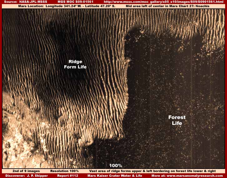
The above second image demonstrates just a small part of a huge area on the left and upper of what I have long ago termed parallel "Ridge Forms" for the lack of a better designation merely because that's what they look a little like. I've also long ago come to the conclusion that this evidence represents life of some kind unfamiliar to us. When you see this life in a viable condition as it is here, it always represents shallow water flows down sloping terrain. The parallel row formations channel the water flow, prolong contact with it, utilize it, and depend on it. So, although the resolution is way too poor to see anything like the shallow water itself in the narrow deep channels between these parallel rows in shadow, you can bet that it is there. Further, the tightly packed extensiveness of the ridge forms seen here indicates that this is a very stable long term water presence situation down this slope.
On the other hand, the darker massed evidence on the right and lower part of the image is forest of life of some kind on more level terrain. If a Earth human was down there, this forest would seem incredibly vast by our terms but it is actually not so relative to the really colossal size forests out in the South Polar Region further south below this point. Although we can't see the furthest extent of the forest to the right in this image, I suspect it is big by our standards but really only represents a relatively limited area of favorable ground water presence conditions near the bottom of the ridge form occupied slope. In other words, it is a patch of forest and not the wider spread regional kind.
This evidence looks a lot like conventional trees and the very tight jamb packed crowded density here says old growth. However, all of this evidence is very dark partly due to tampering tinting but also partly due to solar light absorption. I had to lighten this scene up a great deal just to obtain this limited level of detail. Further, although it obviously isn't some kind of strange geology, it is very knobby and rough looking relative to other conventional tree forests I've seen on Mars making me cautious as to identifying this a conventional trees canopy we might be familiar with. In other words, although I'm satisfied that it is definitely living growth and forest life of some kind, I'm not prepared to say exactly what.
The one good thing about the above evidence site is that it offers the contrast of one type of life evidence in comparison with another completely different type. Both are flourishing and densely packed with each fully occupying their needed conditions. The ridge forms are not interested in the level ground where water pools at the bottom of the slope and the forest has no interest in occupying the slope providing a very sharp dividing line between the two. Neither is going to give an inch and we couldn't ask for a better more informative contrast.

The above third image is of a point further down below the scene in the second image. This portion of the original image strip wasn't as dark and we can see a little better on the right a smaller patch of forest evidence somewhat similar to that in the above second image. However, it is not just seen a little better, the evidence itself here is slightly larger, more coarse, knobby, and rougher than that in the second image scene. So, this patch of life evidence may not be exactly the same as that in the second image. I could be wrong but I suspect that it isn't tree evidence here in this third image but may be some dense large form variety of lichen/mold evidence.
The light color area on the left is mostly ridge forms and something else with all having been covered over. I cannot say for sure what is covering it over? Some of it appears to be smudge image tampering but some of the patterns aren't quite the same as what I am used to seeing in regard tampering applications, especially on the extreme left. So it is possible that a portion of this is some kind of finer texture mold invading and covering up a lot of the ridge form evidence. Regardless, the main thing that I wanted to show you here is the darker more light absorbing patch of forest life on the right where we can get a little better look at it. Surely no one can confuse this patch of life with geological evidence.
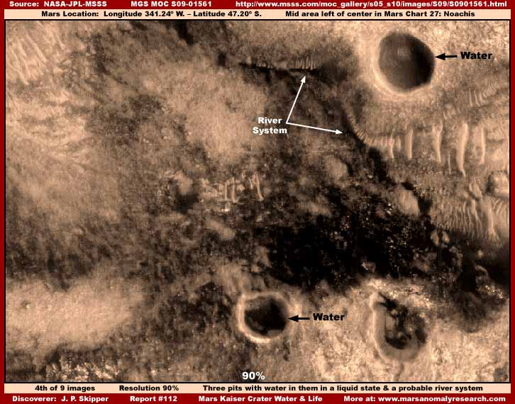
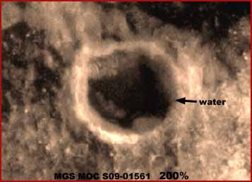
The above fourth image is of a scene lower down in the same strip. Here the primary evidence is surface water in several different isolated spots and, significantly, in a liquid unfrozen state. I had to reduce the size of the strip slightly to 90% to encompass these different spots in a single frame. It must also be considered that this site is in the lower southern hemisphere but north of and outside the northern limit of the South Polar Region and so it may be a bit warmer in this location.
Of course the upper right large round pit in this fourth image is the most obvious and most easily recognized water site and the primary evidence here. The water level on our left side of the pit inside wall can be clearly seen as can the pit shadow thrown onto the right side and bottom of the pit. The clear distinction between the two prevent any confusion with each other as evidence. The transparent quality of the water with the bottom seen through it can also be clearly seen further demonstrating that the water is not shadow but a self leveling liquid substance substantially filling the pit.
The smaller round pit on the left at the bottom of the image is slightly less obvious but still reasonable strong as evidence, especially upon closer view and examination as appear in the image of it below. The roughly elliptical shaped pit to the right of it along the bottom of the image also has water in it but it is less well seen and recognized and so I make no issue of it here in light of the top right pit evidence being so strong.
Note that there is also a river system pointed out with the white arrows just below the top right pit evidence. It's obvious to me with my experience but might be less recognizable to some viewers. For that reason I usually do not report evidence at this recognition level but here it is with other stronger evidence and so I am compelled to point it out. This is not a creek but a larger river system and once that is realized, it serves to provide a measure of true distance and scale to what we are seeing here in the larger top right pit and its truly very large size.
Just below and slightly to the left of the "River System" text in the image, is a cluster of some narrow light color objects. Close examination suggest that some of this could be building structures but all of this evidence at this smaller size scale is at the limit of original image strip resolution meaning that one can't be sure enough of this. Some of this could also very well be ridge forms beginning to establish in this location and, in fact, it could be both. I mention this only because I know that if I don't others will question me about it. So for those, just be aware that the scale on this evidence is just too small and resolution compromised to be sure of exactly what this evidence may be.
 —
—
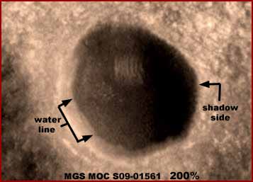
The above left fifth image and the right sixth image are closer views of the two best water pit evidence sites demonstrated in the fourth image and, for the most part, speak for themselves. This was as close as I could get without destroying too much of the evidence detail as the image gets more and more blurry.
In the left fifth image, note the obvious clear water and water level line on the left pointed out with arrows. Note the darker and quite separate shadow on the right side indicating that this pit is rather deep with very steep inside walls. Note also the sort of rectangular shaped object in the bottom of the pit. This appears to me to be underwater and there is enough size scale here in the larger pit to determine that these are half a dozen or so short parallel ridge forms. Now ridge form evidence most definitely does not form underwater or for that matter in pooling water of very much depth, only a in very shallow surface water conditions and much preferably flowing water.
This evidence near the bottom of this pit means that this pit has been dry at least in this particular no doubt slightly elevated spot near the bottom and that it is a slope on a portion of the pit wall. That in turn means that this pit probably experiences periodic sustained dry spells long enough for this ridge form evidence to try and establish on this slightly elevated sloping spot. So the clearly seen fairly substantially high liquid surface water level seen here in this large pit at this time is more than likely not that permanent.
The right sixth image pit is on a smaller scale and more negatively impacted by the generally poor resolution of the image making details a bit less distinct and more blurry. Even so, the evidence is still reasonably strong and especially since it is located in the vicinity of the much larger pit with a liquid obviously in it. Note that it is not nearly as deep and has more shallow sloping inner sides than the large deeper pit creating little shadow. Further, the water in it is more shallow but that's about all that can be said about it.
You'll note that I have purposefully avoided identifying these pits as craters. That's because they do but also don't much resemble craters in a few too many ways. These pits could be due to long dormant volcanic activity in this area but we can't be sure of that either based on just these visuals. Further, while traditional mainstream scientists would never break from the herd and consider this at this point in time, there is considerable long established civilization presence on Mars in general and in the Kaiser Crater in particular and independent thinkers should never discount the impact that advanced technology can have on the Mars terrain either in the creation of such pits or the modification of naturally existing geology to take advantage of them.
In fact, this gets to the reason that I chose the Kaiser Crater location to draw this water and biological life sample evidence from. It is a strange place of much variety and includes not only biological life evidence seen here but also some of my most important active civilization evidence with advanced technology.
For example, there is my earlier year 2000 Report #010 of an extensive industrial operation at work in Kaiser Crater complete with a super brightly lighted huge dome that probably represents some kind of high tech processing contained inside it. Also a nearby industrial plant under a very clear dome actively puffing vapor from a mostly horizontal exhaust stack sticking out the side of the clear dome. The fact that this plant was puffing vapor means that this high tech civilization evidence represents an active operation and not some old ruins. Further, incredibly, this discovery was made in very heavily obfuscated old 1970s Viking science data.
Then there is my year 2000 Report #009 of a likely disguised very sophisticated dual dome system. The vertical round component of the dome system has an opaque top surface controlling light transmission into the interior and is tightly surrounded by thick rock while the horizontal component extends out to the side of the rock formation into the open tapering onto the ground and changes sharply from a opaque material to a very clear material as a likely passive solar energy control function.
Also, you should know that the upper portion of this S09-01561 narrow-angle science data strip above the point of my second image is extremely dark so that not much of anything can be seen there without a great deal of lightening work on the image. Part of this is due to a artificial dark tint put on it to obscure but a significant part is still due to a massively huge dark light absorbing dune complex. Having reviewed all of the publicly available images of Kaiser Crater, I can tell you that some of these dunes are dark sediment dunes but some are something that is an amorphous cohesive mass that mimics the dune shape but can change shape, surface texture, light absorption, and may be a living organism. In fact, it is the same evidence as appears in my 2003 Report #049 titled "When Dunes Are Something Else" and my 2005 Report #088 titled "Mars Strange Colossi."
Likewise, even the biological forest life you see here in this report has been seen as very similar evidence in my earlier reporting. For example, check out 2002 Report #042 titled "Densely Packed Life Evidence" and 2002 Report #040 titled "Clouds of Atmospheric Moisture" and specifically the fifth image in that report. Like here in this report, the biological life in those earlier reports are somewhat like conventional tree forest canopy evidence but in other ways not like it implying that this evidence may be similar but different.
In any case, with all this background information under your belt and in mind, let's move on to the evidence in Part-2 of this report at the link below.
DOCUMENTATION
http://www.msss.com/moc_gallery/s05_s10/images/S09/S0901561.html: This link takes you to the official S09-01561 science data strip from which the evidence in Part-1 of this report was drawn. I as always when available used the slower loading but high detail straight .GIF strip to develop my imaging from.
, Investigator
![]()