
MARS RICHARDSON CRATER ENIGMA
Part-1
Report #129
October 31, 2007
Part-2 .... Part-3 .... Part-4
Even though it's Halloween today here in the USA as I post this report, the subject of this reporting is very real. For those of you overly confident that man and his ways rule the cosmos, the life discussed here may just give one pause in that regard.
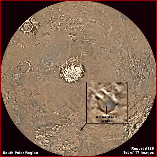
The above first image is the MGS MOC Mars Chart 30 and it shows a wide-angle global context view of the Mars South Polar Region with the South Polar Cap shown in the very center. The subject of this reporting is the "Richardson Crater" site pointed out with the black arrow. This global context view will serve to demonstrate where the site is located as well as the colossal scale involved here. Note also that the enlarged inset of the the site attached to the black arrow is included here to demonstrate the true orientation of the site. The next enlarged view of the evidence site below complies with this orientation.
Now in this shorter reporting style I'm going to try and tackle original discovery evidence here that may strain some brain pans to the limit and my credibility along with it. You should know that this particular site is one of the most repeatedly imaged on Mars. The official reason given is that this survey work is a consistent program of "Richardson Crater dunes seasonal monitoring." The "seasonal monitoring" part is no doubt correct but the "dunes" characterization in my opinion is not. The latter is just a label to misdirect perception away from the real truth here. On the other hand, it is true that monitoring this site with repeated imaging is a lot about "seasonal" changes at this site.
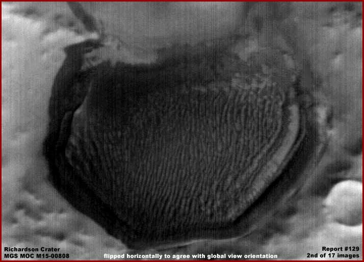
The above second image from an enlarged M15-00808 wide-angle regional image demonstrates the whole site science data strip of the site with a little bit of its surrounding terrain. Note that this image has been flipped horizontally from the original so that its orientation agrees with the one in the further above South Polar Region global imaging view. However, since there are a lot of images in this report, this is the only image treated in this manner and subsequent images of the site will be in the predominant original science data view orientations as released and not matching the above orientation so as not to confuse those who wish to verify this evidence behind me in the science data and save them from having to manipulate images or do any mental gymnastics any more than necessary.
The main purpose of the above closer but still very distant view is to demonstrate the general shape of the site and its strange looking content densely packed within its boundaries. As you can see the site interior appears to be primarily a great many parallel densely packed ridge forms and these are no doubt suppose to be the officially identified "dunes." Right off I have a problem with that official identifying moniker because these are most definitely not sand dunes.
Now look closer in the above image. Note that there is a very subtle octagonal pattern to the total perimeter shape that we can see with respect to the well defined sides and front/lower edges. Note how those front and side edges appear to be distinctly rounded and rolled formations having in this view and almost tube like appearance. You will discover later in this reporting that these consist of boundary material serving as a barrier very similar to that in my recent Report #127 but without the influence of any artificiality that we might recognize. Now note that the rear or top portion of the site has no such well defined boundary or edges at all. Take note of this open end feature as this will become important to understanding later in this reporting.
Doesn't look much like a crater does it. In fact I can't confirm whether there is a actual impact crater present here or not and will leave that determination to geologists. What I can confirm is that there is something else here and it isn't inanimate geological matter sand dunes despite the official misdirection interpretation. It is something very unusual and strange to the Earth human experience. That not admitted to factor is much more the reason why it is being monitored fairly closely. What could it be? Could it perhaps be a disguised base or city? Nope nothing like that is indicated at all, at least not from the visual evidence we have here.
Finally you should have some idea of the scale involved here with the Richardson site. According to the official statistics the in conjunction with my rough measurements, the site is roughly 66.86 km or 41.54 miles across horizontally. Keep that huge scale in mind when you are examining the regional view images below.
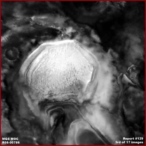
The above third R08-00786 wide-angle image of the South Polar Region Richardson site demonstrates the site with darker terrain surrounding it. In the theoretical but officially promoted no life on Mars scenario, the dark colored terrain around the site would logically mean that the general area is going through a warming trend that is making accumulated covering carbon dioxide snow/ice sublimate and go away exposing darker material underneath as the preferred sole explanation.
On the other hand, in my visual evidence driven scenario here in this reporting, this could theoretically mean that biological life is proliferating during the seasonal warming trend and the darker coloration around the site has a lot to do with dark color bio-life proliferating growth absorbing solar light radiation just as it does here on Earth. The point is that in either scenario, there can be no disagreement that a seasonal warming trend is in evidence here at the time this image was taken.
However, note in the above image that the Richardson site itself clearly retains its bright very light reflective quality in the face of this obvious general seasonal warming "sublimation" trend. Now, if this is an impact crater and the crater depth is deep enough, which it doesn't appear to be, the temperatures in the crater's interior lower levels could continue to be colder still retaining a snow cover and therefore the bright reflective quality for a while. That is what the official interpretation would no doubt have us believe along with the concept that those many tightly packed ridges are sand dunes. However, take a look at the next image below.
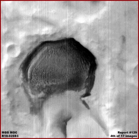
The above R10-02083 wide-angle fourth image demonstrates the Richardson site from a time period in a region wide colder season. As you can see, the surrounding terrain is now thoroughly covered by snow/ice giving it that highly reflective of solar light quality. On the other hand, you'll note that the Richardson site itself now is much less covered by snow/ice and is much darker than its surroundings clearly defying the cold conditions in this one very well defined now isolated location.
You should be aware that there are many wide-angle images confirming this type of apparent transition dichotomy between the site and its surrounding terrain where the Richardson site appears to operate contrary to the regional seasonal cycles it exists in. This defies any geological only explanation and you can now begin to get some insight into why this site is the subject of repeated imaging or the years and seasons and so much official interest.
One might argue that this is a crater and that its lower level depths are warmed by underlying volcanic geothermal influences. Sounds like a reasonable explanation if we considered only image evidence like the above fourth image but what about the previous third image evidence and so many others spanning years? You just can't have it both ways. The site simply works opposite of the way it should in the changing seasons. If this is a crater site with underlying geothermal influences, then why isn't the thermal warming effective in the general atmospheric warming trends as represented in the third image right when the thermal influence would logically be most effective?
The truth is that I have delayed reporting on this huge Richardson site for over seven years. Why? The answer is to give enough time to elapse so that enough images of the site could accumulate that spanned those years and warming and cooling seasons. The true simple fact is that snow/ice accumulates in this site's general regional area on a seasonal basis. The mystery is that the snow/ice in the surrounding area goes away in the regional cyclic warming trend responding well to geological principles while the site itself remains covered by snow/ice contrary to those principles. Likewise, when the snow/ice comes back in the surrounding area in the regional cyclic cooling trend, the site itself grows darker and gets rid of most of it snow/ice cover.
It's impossible you say! Well the visual evidence speaks for itself and tells us conclusively in many repeat images over the years that it is happening in this seasonal and cyclic way contrary to geological only reasoning whether it is suppose to be possible or not. In large part the term "anomalous" was invented to label such conflicting evidence in a way that allows one to psychologically dispose of such evidence by putting it aside out of awareness as well as the responsibility to contend with it. So is that what we're going to be left with here, just labeling this as anomalous and then ignore it?
If so, I suspect that too would be just fine with the secrecy agenda as I'm sure they will willingly accept the association of the concept "nebulous" with evidence like this if they can't achieve outright ignorance of it. I doubt that it ever occurred to them that someone without the benefit of their much clearer and closer and no doubt color imaging held in secret would ever in this poor imaging catch onto the fact that there is an issue here other than being merely "anomalous" and strange must less be able to figure out what is really going on.
In any case, there is fortunately just enough evidence available to get this figured out in main part as you will see in the subsequent parts of this reporting. Now let's move on to Part-2 at the link below.
DOCUMENTATION (for Part-1)
http://www.msss.com/moc_gallery/m19_m23/mc30.html: This link takes you to the official MGS MOC graphical Mars Chart 30: Mare_Australe that is the source for my first and global image in this report.
http://www.msss.com/moc_gallery/m13_m18/images/M15/M1500808.html: This link takes you to the official MGS MOC M15-00808 science data image that is the source of my second image in this report.
http://www.msss.com/moc_gallery/r03_r09/images/R08/R0800786.html: This link takes you to the official MGS MOC R08-00786 science data image that is the source of my third image in this report.
http://www.msss.com/moc_gallery/r10_r15/images/R10/R1002083.html: This link takes you to the official MGS MOC R10-02083 science data image that is the source of my fourth image in this report.
![]()