
MARS "DUNES" ARE
SOMETHING ELSE
Report #099
February 20, 2006
I've visited this subject matter in the past and I'm coming back to it here again in this report. Further, I may even visit it again in the future if I can accumulate the right evidence for it. I'm trying to get a some points and some insight across on this that isn't readily apparent to the more casual visual observation. When you view many tens of thousands of images as I do, you gradually gain accumulative insight into anomalous evidence that it very difficult to readily share without resorting to overwhelming viewer's senses with tons and tons of subtle evidence that there is no room for here in this shorter reporting style of mine. The only way to try is to keep coming back to it presenting visual samples along and along and try to point out evidence that is often very subtle.
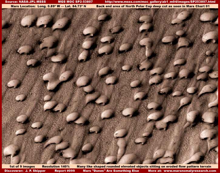
For example, the above many objects you see here in this first report image are officially and specifically identified as "dune fields" in Chasma Boreale. Now Chasma Boreale is a big long wedge shaped crease/indention/cut in the lower portion of the North Polar Cap, as viewed in Mars Chart 01, that reaches far up into the Cap overall surface and extends down beneath to the underlying Mars terrain upon which the North Pole Cap ice rests. This Chasma Boreale feature almost but not quite divides the Cap into two parts. The evidence here in this first image is located to the right at the very back of the Chasma cut where it narrow tapers and ends into the Cap surface.
Now "dunes" as they are normally thought of here on Earth are formed by accumulations of loose particulate sediment blown up into growing elevated piles by the wind. Individual elevated piles increasingly and partially blocking wind flow accumulate more and more wind carried sediment piling up against their upslope side on a increasingly broad spreading front until they start interconnecting with each other forming the sand mingling sand dunes that we are familiar with here on Earth. I think that most of us are familiar with what these Earth sand dunes look like in deserts around the world. The key to their elevated formation though is the presence of loose particulate sediment (sand) in the general surrounding terrain to facilitate their formation.
Now, among other things, the secrecy agenda promotes the official supported concept that Mars is a no surface water dry as dust world characterized by occasional huge sand storms that can sweep around the planet on a global scale and sci-fi movies take this ball and run with it in their story lines and graphic representations and scenarios further sticking this concept and perception of Mars in our heads. When a dark self leveling substance is seen well defined in a Mars depression looking exactly like a body of water where we might expect to see it, there is usually always an accompanying official identification that this an accumulation of "dark sand" completely ignoring the fact that the so called solid particulate "dark sand" also has a transparency factor just as would be the case with water complete with bottom contours as seen below and through it. To me such attempts at perception manipulation are so incredibly pathetic, lame and even laughable. Unfortunately, it is also accepted by the science and academic communities apparently at face value and that is no laughing matter at all.
Likewise, to continue to pound home the dry as dust perception crapola in our heads and control us via ignorance indoctrination, all dark streaks in the Mars terrain are officially identified as dust devil trails and all smooth elevated rounded and/or elliptical aerodynamic shaped objects in the Mars terrain are officially identified as dunes or dune fields to prevent independent thought processes from going off in unapproved directions and pound home the dry as dust perception. Now don't get me wrong here, there are legitimate dunes on Mars just as they are here on Earth and dust devils generating dark streaks will form in these dry areas just as they do here on Earth. Further, on the lee windward side of real Mars elevated dunes, sometimes concentrations of many multiple dark streaks will form as wind passes over the upslope to top of the dunes and then vortexes form on the sharp drop down lee side of the dune forming similar dust devil directional patterns consistent with the prevailing wind direction.
However, what is true on Earth isn't always true on Mars because it has evolved along some entirely different and unique paths than here on Earth. After all, Mars is an older and different world in many ways. Further, consider to that it may have been influenced by technologically advanced civilizations for far longer than here on Earth and there may be an impact from that factor as well.
Take the Mars dark streaks for example. Dark streaks on Mars are more often than not in more random crisscrossing patterns often demonstrating pronounced wiggle patterns along their length rather than in typical dust devil prevailing wind directional patterns. Further, such crisscrossing streaks are often abnormally huge and unusually long. Probably the most anomalous evidence of all though is that this dark streak evidence is very often confined within a mostly transparent to semitransparent clearly defined and isolated area space in the Mars terrain and the streaks go right up to the edge of but NEVER cross over the space's perimeter boundary. Such streaks are often also embedded within and confined within the outer perimeter boundaries of dark semitransparent bodies of water and masses of some kind.
They and their unique characteristics are often found within dark solid to semitransparent colossal size masses that change both shapes and surface textures. At other times they develop solid hard very light reflective aerodynamic visually appearing wind swept "dune" looking surfaces, which of course is why are they are officially identified as dunes trying to capitalize on this perception. But, at other times, these so called "dunes" actually change shape to smooth rounded elliptical domed looking surfaces bulging upward that can also lean and stretch to and roll toward one side demonstrating thinly stretched material on the stretched side. When this latter state is developing, they also appear as a very dull dark much more light absorbing surface that can also develop into a still dark but quite semitransparent surface. When this happens, the dark crisscrossing streaks can clearly be seen in their interior and these streaks NEVER cross over the mass outer perimeter boundary edge.
Evidence of these strange colossal size masses can be found in my previous Report #017 titled "A Puzzle! What Is This?" and my Report #049 titled "When Dunes Are Something Else" as well as my Report #088 titled "Mars Strange Colossi." When you look closely at this evidence, it certainly doesn't look much like sand dunes now does it? To put it bluntly, that's the whole point!
If we assume that professional incompetency at the science and academic level is not the primary issue here, then someone is going to a lot of trouble trying to misdirect our attention away form developing a independent questioning attitude directed at this type of evidence. Why? Because it's just too huge in size and too plentiful in different locations on Mars and spread over larger areas to be hidden practically by object specific image tampering as has already been done in many hundreds of images in the northern hemisphere lamely explained away as smooth (no dune shapes even) sand that is really just tiny pixel level geometric patterns blotting out and hiding everything below it. Can't have too much of that kind of thing or the tampering might become apparent. So the solution is to psychologically explained away this type of evidence into something as innocuous and harmless as "dunes" or "dune fields. In other words, we're peeing down your collar buddy but we're going to try and convince you that it is really raining.
So why am I talking about all this apparent digression from the main topic of this report? Well because I want you to think for yourself and do more questioning of EVERYTHING rather than just blindly accepting the official pabulum output that keeps putting us all deeper and deeper into ignorance reinforcing fear of truth and weakening our ability to cope with new concepts and information. This so called "dunes" evidence that isn't really dunes is very subtle and not easy to understand but yet is still very important to understanding our sister planet Mars and what is really there.
When it comes to evidence like that in the first image here (scroll up and take another look at it), the official indoctrination would have us think in terms of wind swept making the next step of regarding them as "dunes" and "dune fields" so much easier. It is how the secrecy agenda gets into and plays with our heads. However, I'm going to ask you to also think in terms of aerodynamic design when you're viewing and thinking about this evidence. Many artificial created objects and machines here on Earth are heavily influenced by aerodynamic designs including natural designs demonstrated by sand dunes, it is after all what we have test wind tunnels for.
Note in the above first image the smooth rounded elliptical elevated dome shaped look of the many "dunes." Now look at the variegated flow (notice I didn't say wind) pattern clearly seen in the terrain in the above first image clearly demonstrating same direction flow. Note how there is a subtle but still pronounced lee side flow pattern behind each object moving from each object in the angled direction toward the top of the image. However, also note that most of these objects not only demonstrate a visible concave hollowed out notch on one end of their elliptical shape, they are all on the same end and pointed at an angle down toward the bottom of the image. With variations, this aerodynamic shape and concave notch is typical of this particular type of Mars evidence.
You can see a much closer and clearer view of a variation of this aerodynamic notch shape and its end development by scrolling down now and viewing the sixth image in this report. They are a beautiful design aren't they? Not only is this design very aerodynamically functional, their smooth elevated rounded aerodynamic elliptical shape is also very graceful and esthetically pleasing to our Earth human eye. It is literally art. Note that they have a rather rounded but still pointed front-end while their pronounced concave notch out area in the rear-end forms two wing extensions on the outer edge that gracefully curve slightly inward at the tips. The tiny amount of slipstream bleeding out just a bit into the terrain to the right behind the object's concave wings demonstrates that this is indeed the rear-end, at least when it comes to the wind aerodynamics. Looks like it could be ready to take off and fly doesn't it. So, if we find it so esthetically pleasing design to the eye, then why wouldn't someone else on Mars?
Yet for all the object's practical aerodynamic (perhaps even wind tunnel inspired) shape wind functionality, take a closer look in the above first image. Even though this is a very distant view compromising important finer detail, it can still be seen that what ever flow force strong enough to create the heavy flow erosion patterns in the terrain around and under the objects, it did so flowing against the concave rear-end of the objects without accumulating or piling any solid particulate up against that concave end and yet without leaving any lee side flow pattern solid particulate sediment evidence behind the front-end.
This observational fact quickly eliminates wind blown sediment/sand scenarios as having formed either these heavy terrain erosion flow patterns or, for that matter, having formed these elevated objects as sand dunes. As you can clearly see, there is hardly any evidence of sediment deposits thin or thick in this area that could have contributed to a "dunes" scenario and, even if there had been, such a scenario wouldn't have created all these many even spaced isolated objects as dunes. Quite the opposite, the object's concave rear-end would have essentially acted as a cup catching and holding onto a considerable amount of accumulated wind blown sediment essentially burying the concave end as visual evidence. You just can't have your cake and eat it to.
I suspect that what happened here in this first image is that we are looking at evidence of the aftermath of a disaster but one that may have turned out to be survivable for most. I suspect that these above ground objects are much larger than they appear to be in this image. I suspect that each of the objects are very high technology artificial shelters harboring life of some kind and that their design shape is not fixed and permanent but can be manipulated and altered at someone's will.
Of course I can't know for sure but I suspect that the object's design that we see is actually wind aerodynamic and oriented into the prevailing winds of this particular North Polar Cap location but that the area was hit from the exact wrong direction in each object's rear-end by FLUID flow speeding across the flat relatively level terrain strong enough to distort a few of the objects and even destroy a few others piling up a slipstream debris field behind them as well as undermine many others in an event that was so sudden and immediate that it did not allow any time to redirect structure shapes pointed into the fluid flow. If you will look very closely and carefully, you will see that some large number of the objects show evidence of being undermined in the worst of the eroding flow force as evidenced by the flow patterns going under them. Further, strong water flow scouring the rear-end concave area in vortex created by the rounded concave shape and then going on over and around the otherwise smooth rounded dome shaped structure would easily explain why no sediment/debris build up there in the concave area.
Did you take that first link at the top of this report and take a look at the North Polar Cap and the Chasma Boreale deep cut in the lower portion of the Cap where this evidence is located in the very back of the cut where it tapers to an end? If not, at this point, take a look at it again here in Mars Chart 01. How do you suppose that Chasma or cut was formed into the Cap? Light bulb going off yet? It's a clue and also maybe a lesson to be learned, at least for someone on Mars. Don't locate where things can happen too suddenly for you to adapt to them in this Chasma area or you and you stuff can get seriously messed up.
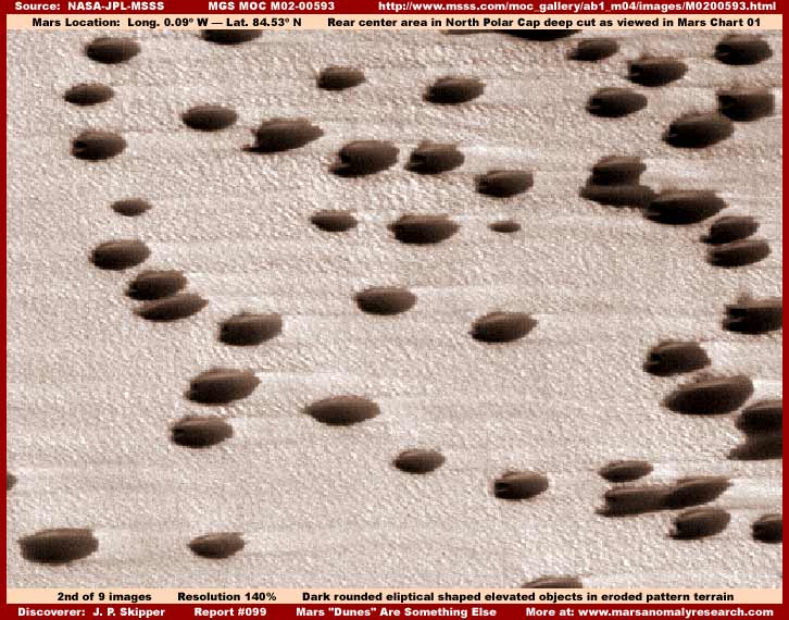
The above second image is also taken from another strip in the Chasma Boreale area but just a little forward to the left from the back area. As you can see, it is essentially more of same with similar if a bit less pronounced terrain flow patterns clearly oriented from left to right. Sadly, the evidence objects here are dark and featureless relative to the kind of detail in the first image because each one appears to have been blotted out by image tampering applications. I suspect this has been hidden in this way here because the view of this evidence was at a more oblique angle that would have provided a bit of profile view and that would have been much more informative than the straight down view, so it had to go.
Even so, there is still some detail left in the terrain itself as poor as it is and it does tell us a few things. Again these objects in this strip are officially identified as "dunes" but again you see how spaced out, isolated and independent each of these objects are relative to each other. This just doesn't fit the wind blown sediment or sand "dune" scenario. Also, again, note how there is either none or, at least in the most generous assessment, insufficient sediment resource evidence in the wide terrain to support a "dunes" scenario. Further, just as in the first image evidence, winds strong enough to heavily scour and erode the terrain surface as you see in these images, would also be strong enough to take away piles of sand/sediment. That these objects are so tough and resistant to such wind or water flow forces as evidenced by their continued presence, again defies any "dunes" scenario.
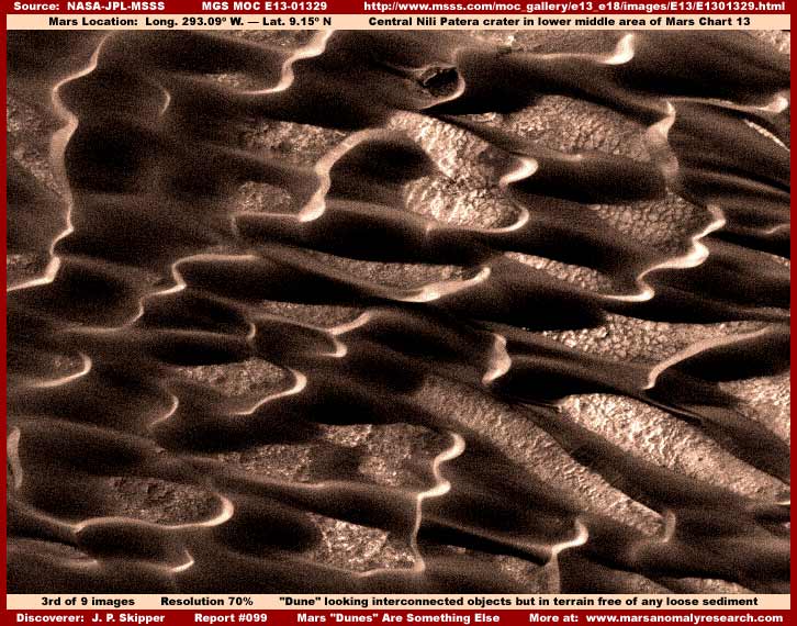
Now the above third image evidence at first glance really does look sort of like interconnected sand dunes doesn't it. Even so, I suspect that, if they are actually real ground level evidence and not a form of fake image tampering covering up something specific here, these are not dunes but something designed to mimic the look of dunes and serve in that manner as camouflage. Why do I say that? Well look very closely and carefully. Note how the visible terrain between the forms is so free of sediment evidence.
Just not enough you say and you want me to note how the wind could have been strong enough to scour the ground in front of any particular dune and deposit the sediment on the dune's wind upslope side. Huh! Well here's my response. I'd point to the drop down back end of each dune demonstrated by the stronger sunlight reflection there and ask you to examine the ground there very closely as well. In most cases it to is free of sediment evidence. Any wind strong enough to scour the ground in front of the dune free of sediment would also be strong enough to flip sediment over the top and down the back onto the ground there. A few places show evidence of this but most don't and wind forces are just not that selective.
This kind of evidence is very anomalous. I can't say what exactly is going on here but I can say with good confidence that in this particular spot it isn't natural geology going on in the form of wind blown "dune" evidence. Rather, I suspect it is something creatively designed to look sort of like dunes and pass a casual aerial observation in that manner. Like all this kind of evidence that doesn't fit what it is suppose to visually represent in one spot, nearby can be found "dune" evidence that better fits the scenario and which may or may not be legitimate. Although evidence like that presented here does not pass closer examination as to what it is suppose to visually represent or fit the official description, its covert aspect is missed by the casual observer assuming that it is the same as nearby similar looking evidence by visual association.
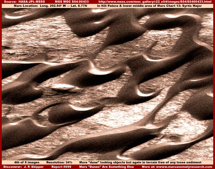
The above fourth image "dune" evidence is from the same general area as the third image. It is just more of the same kind of evidence only here the "dunes" are more widely spaced showing a lot more terrain exposure in between. You should be aware that the official image was very compacted and in error and that lends a bit of a distortion factor to the evidence. Elongating the image would have cleared this up considerably but I haven't done that here trying to keep my own image manipulation to a minimum. However, the terrain that is clearly essentially free of sediment resource on the ground on both the front back side of each "dune" tells the same story as in the above third image.
Again I can't know what is under these "dunes" but their being so sharply defined in the terrain and without the presence of a sediment resource that could help explain them is certainly evidence that just can't be ignored. Despite their aerodynamic shape trying to mimic and suggest wind swept dunes, something entirely different is going on here that doesn't seem to be explain by natural geology. Again I suspect this evidence resulted from intelligent life but living in a covert manner. On the other hand, perhaps it is some underground life that generates sediment on the surface and concretes in place as a cap. Alternatively, maybe it represents an old long gone intelligent life that reinforced this making it incredibly tough and perhaps the forms have survived for eons being scoured clean by Mars winds eroding it only a little at the time and eventually sculpting these shapes but now no longer with any produced no visible sediment drift evidence.
I must also mention that there may be a monkey wrench in the works here. Why? Well because the file size on this fourth image is unusually high. As I've reported before, this usually means that my graphics software is counting a large number of individual objects down there. Yet we visually see only these huge "dune" objects and what appears to be natural terrain detail between them and that most definitely would not warrant this kind of large file size.
Therefore, I must logically seriously consider that the scene we are looking at may not be real and may the result of "creative" image tampering. Alternatively, perhaps the software can see into the interior of these structures? I doubt it but admit that it may be possible. As for me, the image tampering scenario is strong because I have seen shapes like this that I've strongly suspected of being falsified in the terrain. For example, similar smooth ridge form shapes crossing straight across craters depressions, canyons and cracks in the terrain without so much as a bump in their elevation. Thought I would mention this but you must decide for yourself.
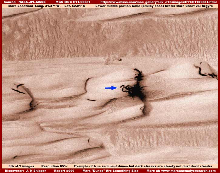
I've thrown in the above fifth image to show you what real natural and typical Martian sediment dunes or drifts look like. Note that the prevailing wind direction here in this one is clearly evidenced in these trailing drifts and their much more obvious surface textures very unlike the previous evidence presented here. At least I know that here we are looking at the real thing.
I would have made the image darker and sharper so that these true deeper textures of the sediment dune could be better seen. However, that would have come at the expense of the dark tangle streak evidence as pointed out with the blue arrow darkening and obliterating far too much. Here we have some very pronounced dark streak evidence that certainly isn't dust devil trails or for that matter dark streak evidence confined within a well defined space as I've previously described.
If it looks to you like something very dark and very strange emerging in numbers from this shallow drop down dune ledge, it looks very much like that to me as well. This is a distant view and this dark evidence is actually larger than it appears here. It looks for all the world like a nest of huge serpents wiggling around and emerging from this ledge area. Could these be some kind of strange cooters and alive? Did immortal Medusa drop her head here in this spot and her "hair" is trying to escape? Your guess is as good as mine. Mars is indeed a strange place and it gets stranger the closer one looks beyond the official pabulum served up.
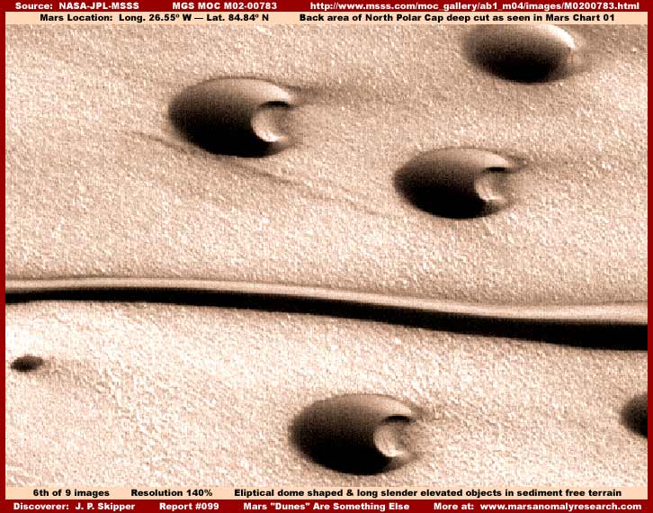
In the above sixth image, I've already talked about the elevated individual smooth rounded elliptical aerodynamic objects with their concave rear-end areas that you see above but take a look at that dramatic long narrow very straight ribbon form. You can determine that this ribbon form is an elevated form rather than a crack or depression by comparing the consistent reflective and shadow sides of the individual rounded objects with that of this long ribbon form. They match exactly demonstrating that this indeed an elevated form with light reflecting off of the top side and throwing short but very dark shadow on the bottom side.
There are actually several of these very long ribbon forms or objects in this one M02-00783 image strip and all stretch from one side of the strip to the other side. It's like seeing only the middle of the body of snake on the ground without being able to see its front or rear ends hidden from view. You should also know that this evidence is located on the North Polar Cap in the Chasma Boreale just like the first and second image evidence at the beginning of this report but a little forward away from the back of the cut. Doesn't look much like a sediment "dune" to me, now about to you?
Please note that this distantly seen very sharply defined long narrow form is oriented in the same direction as the obviously aerodynamic individual forms. That makes it just as or even more so aerodynamic as the individual rounded objects. Note to the uniform texture of the terrain these objects are located in and how it is the same as the terrain evidence in the first and second images in this report. Now I want you to take a look at the tube and also the terrain evidence in my Report #035 titled "Buried Tube System" as well as my Report #045 titled "The Real Tubes On Mars: Part 1" and Report #046 titled "The Real Tubes on Mars: Part II."
In each of these prior reports, the terrain surrounding the objects in question is the same as the evidence in the first, second and sixth images here. This tells us a few things. First, this type of terrain is not a function of the North Polar Cap surfaces as per the evidence presented here in this report but something common to all the areas these objects are found in regardless of where they are found including far removed from the Cap. Further, it looks very much like coarse but graded very uniform ground up fill rubble rather than any kind of true natural geological terrain. I must also mention that this terrain also matches that found at the colossal scale "Inca City" site. Take a look at the sixth image in my Report #036 titled "Inca City Ridges" in this regard and while your there take a look at the fourth image demonstrating how the terrain was generally obfuscated from view.
As you can see, this report is not just simply about the evidence contained within it but also about its relationship with other previously reported evidence to gain insight into a greater whole in spite of the attempts here on Earth to obfuscate it. I suspect that all this evidence, when it comes to the objects and forms reported on collectively in the reports identified here, share a common theme very high technology far beyond our own, just with differences in application. I would not rule out that we may be looking at some kind of incredible organic animated protective cover/surface technology. Alternatively, we may even be looking at swarms of robotic nannite technology that can change their overall shape as a collective to fit changing conditions or situations at the will of others and, in doing so, briefly expend tremendous amounts of energy visible as the dark streaks that may be visible plasma fields.
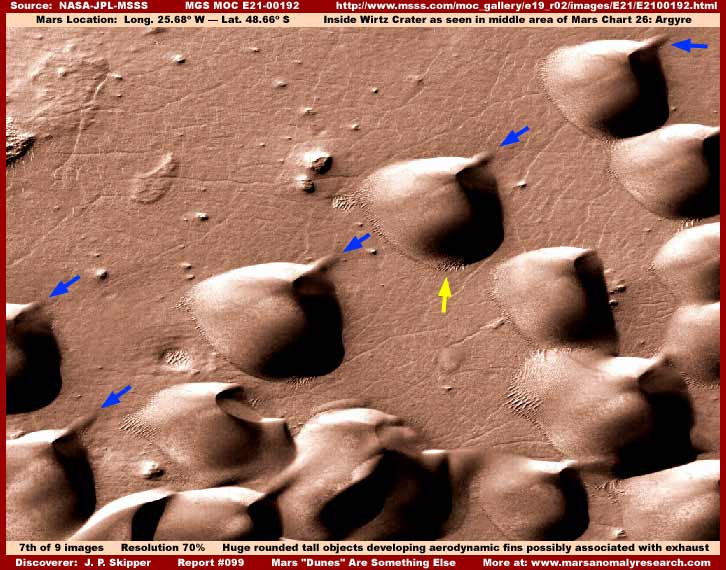
Beginning to sound a little too much like sci-fi fiction and too far fetched to be truth? If so, that is I suspect a function of reactive psychology and emotion and not a function of the evidence itself and where it points. In the above seventh image, let's revisit some officially identified "Dunes in Wirtz Crater" evidence previously presented in Part 4 of my multi-part Report 088 titled "Mars Strange Colossi" from the E21-00192 narrow-angle strip science data.
In the lower left field of this image you can again see the concave feature still pronounced on one of the objects and to its immediate right another one but now the concave feature in that object is beginning to fill in. In this scene, it is not so much the whole object that is changing but rather a more specific portion of it. The end result of this process appears to be the forming of a sort of much elevated aerodynamic tail-fin shape sticking up in this area (pointed out by the blue arrows) that appears fuzzy at its extremities and may be producing some kind of exhaust. Note that all are oriented in the same direction, again suggesting the aerodynamic principle.
As strange as they look, they could still be some kind of strange geology if it wasn't for their relationship to the other so called "dune" evidence referred to here. So let's examine the spot at the base area of one of these "dunes" or "domes" pointed out by the yellow arrow in the final image below.
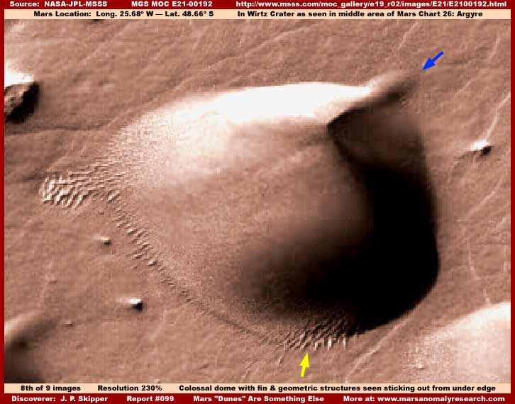
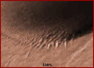
As you can see in the above eighth and ninth images of one of the objects blown up 230% and 330% respectively, the yellow arrow location is clearly pointing out multiple height geometric structures in rows on the ground extending back into the inner perimeter of the object. This demonstrates that these colossi have a transparency quality to as well as obviously very suggestive of civilization evidence. Also, if this is building structure evidence as it appears to be, it demonstrates just how really colossal these tremendous domed covering structures really area and how distant the view of them really is.
Also, the closer view and blue arrow points out the "fin" area and its fuzzy quality as well as the fuzzy visuals to the immediate right of the fin. Could this animated fin shape have been erected in the prevailing wind to provide an air vortex on its right side that would facilitate the vacuuming exhaust effect of some gases or heat from inside the top of this colossal structure? Indeed, upon closer examination of evidence like this, so many of the "dune" concentrations on Mars are most definitely far more than what they seem on casual view and some of these Mars realities are even stranger than fiction.
It is incredibly sad that our leadership in the science and academic communities have so far clearly not looked at this type of evidence close enough to determine that there is so very much anomalous about it requiring a lot more objective in depth questioning and investigation. Worse, if they continue to refuse to do so in light of the evidence revelations shown here in this website's evidence record stuck right in front of their noses, when it comes to the mainstream thinking, our own world may be locked into a inflexible mental block like the ancient world is flat scenario. Believe me, that's not a good thing.
DOCUMENTATION
http://www.msss.com/moc_gallery/ab1_m04/images/SP253807.html: This link takes you to the official SP2-53807 narrow-angle science data image strip from which this report's first image was sourced.
http://www.msss.com/moc_gallery/ab1_m04/images/M0200593.html: This link takes you to the official M02-00593 narrow-angle science data image strip from which this report's second image was sourced.
http://www.msss.com/moc_gallery/e13_e18/images/E13/E1301329.html: This link takes you to the official E13-01329 narrow-angle science data image strip from which this report's third image was sourced.
http://www.msss.com/moc_gallery/r22_s04/images/S04/S0400433.html: This link takes you to the official S04-00433 narrow-angle science data image strip from which this report's fourth image was sourced.
http://www.msss.com/moc_gallery/e07_e12/images/E11/E1102281.html: This link takes you to the official E11-02281 narrow-angle science data image strip from which this report's fifth image was sourced.
http://www.msss.com/moc_gallery/ab1_m04/images/M0200783.html: This link takes you to the official M02-00783 narrow-angle science data image strip from which this report's sixth image was sourced.
http://www.msss.com/moc_gallery/e19_r02/images/E21/E2100192.html: This link takes you to the official E21-00192 narrow-angle science data image strip from which this report's seventh and eighth images were sourced.
, Investigator
![]()