
MARS NORTH POLAR BIO-LIFE-1
Part-1
Report #123
August 1, 2007
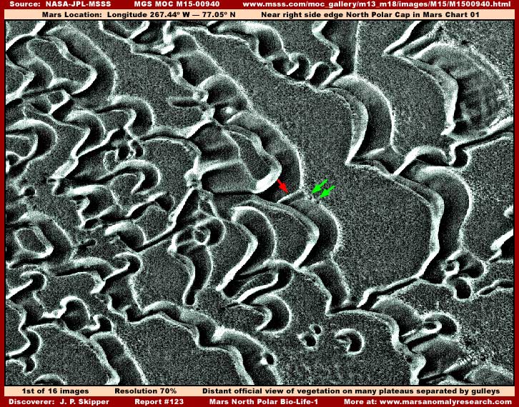
The above first of sixteen images in this 3-part report is from science data narrow-angle strip MGS MOC M15-00940. You should know that all the different strips constituting this reporting are near each other and grouped near the North Polar Cap outer perimeter demonstrating biological life thriving right where it is suppose to be so intensely super freezing cold according to the official position with all the implications that has for the correctness of the official data.
Also each image's file size, although substantially compressed, is very high relative to my usual imaging and so this reporting will have to be split up into multiple parts to preserve a reasonable downloading time for those with slower dial-up connections. This large file size factor usually means that the graphics software is counting a great many individual small objects down there consistent with what this report is revealing.
Likewise I want to warn you up front that most of the imaging available from this area near the North Polar Cap is visibly heavily compromised with many different visual problems due, in my opinion, to many intentional obfuscation tactics. The first strip evidence presented here is in a bit better condition than most and so it may appear better in the more distant views but even that is misleading as you will discover. So gear your expectations accordingly. Even so, despite these visual imaging problems, I think that the main evidence presented will still be readily apparent to most of you.
The above first image has been reduced in size by me 30% from the original size to achieve a full horizontal wide-angle view from one side edge of the strip to the other. According to the official statistics, this view is 3.3 km or 2.05 miles across from side to side. Some may see it differently but for most of you it will appear as though you're looking at very flat terrain cut up all over the place by many wondering funky looking gully depressions. This forms what looks like many flat level plateau like islands separated by these gullies. In one end of the original image strip the gullies are more densely packed and the plateau islands smaller while at the other end of the strip the gullies are much fewer with broader expanses of the flat terrain evidence.
As you can see, even in this more distant view above, the many flat terrain areas are covered by what clearly appears to be darker color light absorbing vegetation of some kind and most definitely is not some rock and soil geology. Now remember this is very near the edge of the North Polar Cap where it can be expected to be extremely cold. To reflect that I've given these normally black and white images a slight bluish tint. Normally my next image would be a closer look at the vegetation evidence here but that's not going to happen here. Why? It's because of the gullies.
I kept looking closer at these gullies but they just didn't seem to me to be geologically adding up right. They appear like they are likely the result of water erosion or collapse but there isn't any sign of water in them at all. I soon began to suspect that my eye was being conned in some way. As I moved on and looked at the many much poorer quality images that constitutes the bulk of this evidence area and which you will not see here, I soon began to suspect what the problem was based on my visual familiarity experience with these winding formations but different looking and in different context settings. So I inverted this image and presto look what leaped out at me below.
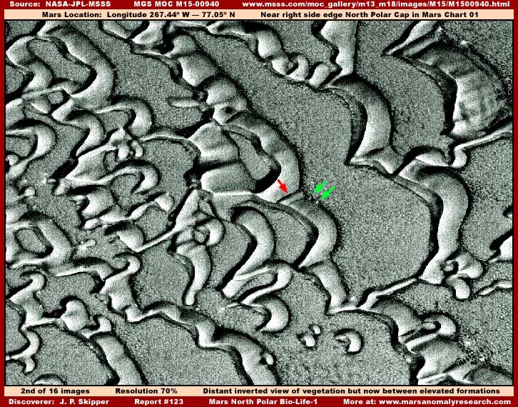
The above second image is the exact same scene as the first image but now inverted. Note the one red and two green arrows pointing out recognizable reference points in both the first and second images to identify that they are in fact the same scene. Even though the general resolution in this image is compromised and the view is distant, I think that most of you can clearly see what needs to be seen. We at long last are looking at something real on Mars and it isn't funky looking gullies or plateaus. Now lets take a closer look below.
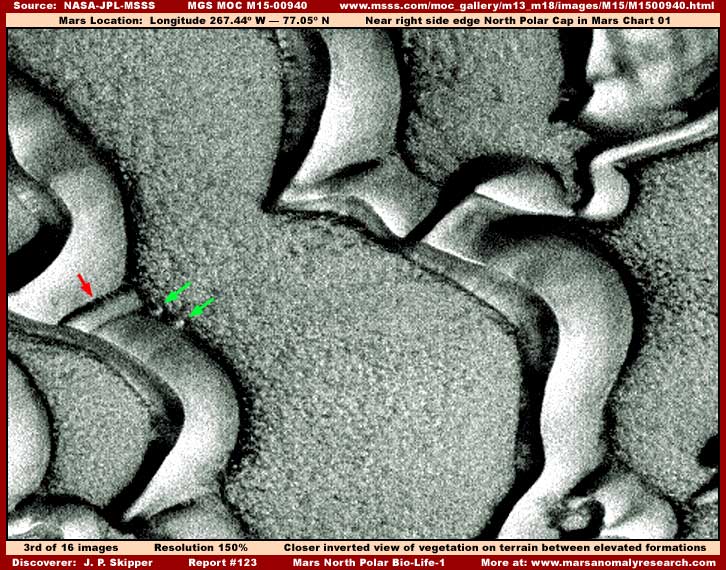
Even with its poor resolution, the above third image closer view demonstrates that we are looking at super densely packed living biological life. Note that the sunlight is coming from our lower right and that the smooth elevated formations are casting short shadows at an angle to their upper left consistent with that sunlight direction. Now move your eyes to the location at the edge of the smooth elevated form pointed out by the green arrows and note the dark narrow line of shadow all along that right edge of the smooth forms.
This bit of shadow is consistently being cast by the densely packed vegetation in the areas where the forestation meets the smooth forms. This clearly demonstrates, just as it appears to be, that the vegetation mass is itself elevated above ground level and not to be confused with ground level rock and soil geology underneath it that it so thoroughly covers and hides. Note how the edge of the vegetation mass is rounded a bit where it meets the leading right edge of the tapered smooth forms and overlaps them just a little. For once we are able to see not just one but other boundary edges of some of this dense Mars forestation.
It's like taking a picture of a center section of carpet and trying to determine with difficulty what one is looking at if one had no other knowledge or information at hand of what is going on other than the picture. Identifying the carpet as carpet would be difficult. On the other hand, if one can take a picture of the edge of the carpet at an oblique angle where one can see the individual fibers from a side view, it quickly becomes apparent what one is looking at. The Mars narrow-angle imaging is most often like that giving us only a look at the center areas of the evidence and not the boundary edges.
But, that isn't all. The presence of the super dense forestation covering all of the terrain geology where the smooth forms are not present, tells us some important things about the smooth formations themselves. Obviously, this density of forestation packed together so tightly competing for ground and sunlight space didn't happen over night and such density is almost certainly the result of a lot of time in development. Look at it! You probably couldn't toss a nickel down there and have it penetrate in that forest. So if the smooth forms are simple solid particulate "dunes" as officially identified, where is the loose particulate (sand) that would have contributed to them?
Let's consider the position that the forestation just more recently covered over the level ground loose particulate and the dunes formed in earlier times and are now all that remain visible due merely to their elevation sticking out of the forestation. As you can see in the above image, the smooth forms are not that tall or they would be casting longer shadows and they taper and are lower on one side than the other. If the smooth forms are just a collection of soil geology, why would the forest evidence not grow at least partially up the lower level sloping flanks? As you can see in the above image, the forest is stopped cold in a sharply defined line by the smooth form's leading edge presence.
This visual evidence suggests that the smooth forms never were or at least are no longer simple soil geology. They are something else entirely and offer the forest no growing foothold at all and act as a complete barrier to the forest growth even though that growth has clearly run out of room to expand and could be expected to be desperate for additional growing space on soil geology dunes. The fact that we have nothing parallel with this here on Earth has nothing to do with it. Remember that this is an alien world with its own unique evolutionary paths. Some things may be reasonably familiar to us and some very likely may not.
I don't know what kind it is but I strongly suspect that we are looking at nothing but many miles and miles of Mars bio-life here in these images with no rock and soil geology visible at all. When it comes to this kind of"dune" like evidence, I have reported this same evolving suspicion in my previous reporting. Take a look at my 2001 Report #017 where I was puzzling with this in the early days of this work and then in my 2003 Report #49 and 2005 Report #088 as these suspicions and this insight continues to evolve.
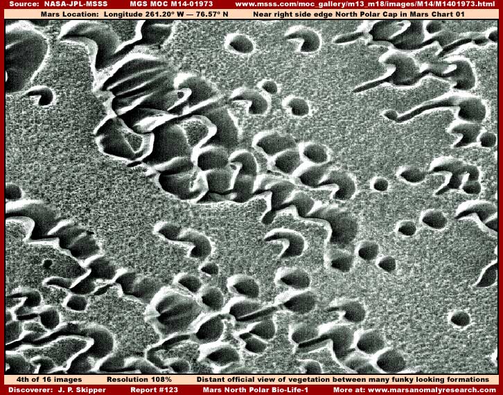
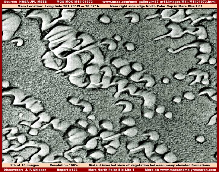
The above fourth and fifth images are drawn from a different M14-01973 narrow-angle strip in this same general site area and represent the entire field of view horizontally from one side of strip to the other side. According to the official statistics that view is 3.25 km or 2.02 miles across. The fourth image is the official science data representative view and the fifth image is the exact same view inverted. This strip is resolution compromised more than the previous M15-00940 strip and will not allow zooming in much closer without getting too blurry. Even so, it is still clear enough to tell which official or inverted view is likely the correct one, the forestation evidence you are looking at, and that it is the same as the evidence in the M15-00940 strip.
I've included this evidence of essentially the same kind to demonstrate to you that the bio-life evidence from the M15-00940 strip is not some kind of aberration fluke or small patch but doing very well widespread in this large area and give you a wide area look at a larger variety of the smooth form evidence for the sake of building some visual familiarity with it. It also demonstrates that the act of inverting these images to intentionally obfuscate the bio-life evidence is also not rare or an aberration but the norm. I've seen many hundreds of images of the smooth form evidence elsewhere on Mars and my inverted view is what it really looks like and the correct view.
Consider this report's M15-00940 image evidence. If you had been skimming over the M15-00940 strip and saw those gullies, what would you have thought and done? If you were relatively open minded, the peaked looking vegetation evidence might have intrigued you but what about the context background of gully systems? The official inverted illusion would have created some recognition confusion and most would have moved on and countless researchers have already done just that without much pause. Now if you were the type that fully bought into the party line, you likely would have never even paused on this evidence for a moment.
But now go back and take a look at the second and third images and again put yourself in the researcher's shoes. Would you have passed over it so readily even buying into the party line? More than likely it would have stopped you in your tracks and especially if you had already run across others like it in an accumulative effect and you would have given it more serious consideration. Could it actually be? That's the secrecy's enemy and why images like this are inverted and obfuscated in many other ways on a routine automated basis. As it happened in this particular case, the official inversion didn't completely eliminate the vegetation evidence as it usually does but it still created confusion and enabled the brain to likely reject the evidence and move on.
As I've said so many times, there can be no adequate understanding of what is really going on with Mars unless one first understands that this tampering business exists and then second how it is impacting the evidence and Mars truth. This report's content is prime evidence of that fact. Now let's move on to the evidence in next Part-2 at the link below.
DOCUMENTATION FOR PART-1
http://www.msss.com/moc_gallery/m13_m18/images/M15/M1500940.html: This link takes you to the official MGS MOC M15-00940 science data image strip from which my report images 1-3 above were drawn from.
http://www.msss.com/moc_gallery/m13_m18/images/M14/M1401973.html: This link takes you to the official MGS MOC M14-01973 science data image strip from which my report images 4-5 above were drawn from.
![]()