
MARS NORTH POLAR BIO-LIFE-1
Part-3
Report #123
August 1, 2007

The above ninth image as well as the 10–12th images below are all four drawn from yet another different MGS MOC R13-03852 narrow-angle strip. With this evidence strip I'm not even going to bother with the official view that I obviously believe has been itself inverted at official level to obscure the bio-life evidence you see here in the corrected views. In this imaging we're only going to look at real evidence and not just at something that others want to limit us to seeing.
Although the resolution in this strip is still relatively poor, it is in the relative sense a bit better than the other strips and so I'm using this strip to showcase the real forestation evidence as best as I can. In the previous images I put a slight blue tint in them in honor of this evidence's proximity to the North Polar Cap and expected cold conditions there but that is a harsh tint that some may not like and so on this evidence I've put a softer slightly green tint to help bring out the detail a little better.
You should know that the view in this ninth image is from one side edge of the strip to the other. According to the official statistics this is a distance of 3.44 km or 2.14 miles. The forestation evidence in the level terrain between and around the elevated smooth more light reflective forms is very obvious here as is the fact that this evidence completely covers and hides from view any underlying rock and soil geology in these locations. Note also how the smooth forms tend to link together in this scene. Above this image point in the strip at MSSS, these forms get more numerous and dense in concentrations with this same forestation evidence squeezed in between.
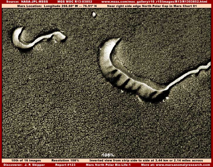
The above tenth is a scene drawn from the bottom of the strip as presented at MSSS. Again the view is from one side edge of the strip to the other that the official statistics say is 3.44 km or 2.14 miles across. I chose this spot because the forestation evidence is a little more course textured and slightly easier to distinguish one individual clump from another in their many thousands. This principle of individual objects of such similar size repeating themselves over and over again in a location is a hallmark of biological life. Likewise these many repeating objects packed in super dense concentrations covering huge areas of geological terrain hiding it from view is also another hallmark of mature old growth biological life that is thriving and doing very well.
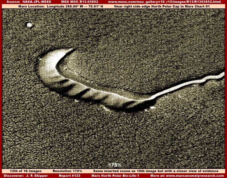
The above eleventh image is a portion of the ninth image scene blown up for a closer look. I could not get any closer than this because the resolution limitations of the base image strip preclude it without getting into too many artifacts and blur. A little closer view like this clearly demonstrates that the level terrain areas between and around the smooth forms is covered with a great many individual objects that are generally of the same size and height and that themselves forming a carpeting effect hiding the underlying rock and soil geology from our view.
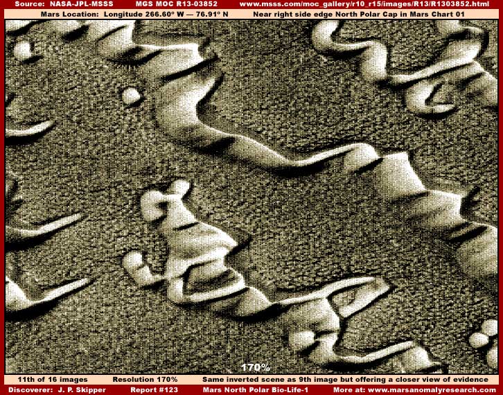
The above twelfth image is a portion of the tenth image scene blown up for a little closer look. Again the forestation evidence is very obvious although the imaging is just beginning to get into a tiny amount of image artifacts due to the relatively poor resolution. This is at the very bottom edge of the strip as seen at MSSS but here the smooth forms have thinned out and I suspect that a vast expanse of this forestation growth continues on from this point over a large area. This kind of thing can be seen in other strips I've examined from this area confirming this but all of those were very heavily compromised images and not of the quality necessary to be shown here.
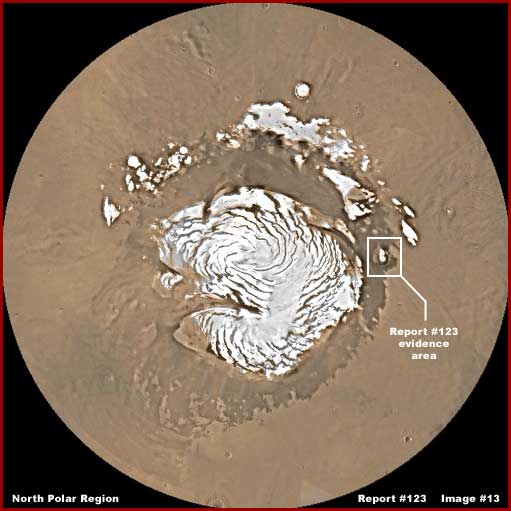
The above thirteenth image demonstrates the Mars North Polar Region and Cap with the area all this evidence comes from pointed out with the labeling just right of center in the image. By far the bulk of the many available images in this area are heavily compromised with many problems often to the point of being essentially blank of information. So don't expect much and be patient if you try to research this area in the available image sets.
If one does very much research there, one will quickly realize that just about every image that much of anything can be seen in has the smooth form evidence in it and in a great variety of shapes from many small to large individual objects to chains of them and even in very dense concentrations that do actually appear very dune like. The truth is that this smooth form life evidence presence is very thick in the terrain all around the North Polar Cap. Some of it may be solid particulate dunes but a great deal of it, if not most of it, is something else representing life but that is a story for another time and place.
Before ending this reporting, there is a mysterious anomaly in the above defined evidence area that I'm going to bring to your attention. It doesn't necessarily have anything to do with biological life but it is very mysterious and represented by the three side-by-side representative sample images below.
Officially
identified as a crater at Longitude 271W — Latitude 77N
 .
.  ..
..
Imaged 1/25/2003 ...................................
Imaged 2/23/2001 ...................................
Imaged 12/22/2002
Is the inside of this crater lined completely with crystals or mirrors madly reflecting sunlight? Is there some subterranean light source? Are the crater visuals fake? These three images have no graphics work in them except for my labeling and are just as they appear in the science data without any enhancements by me. As you can see this hole is a like the interior reflective area of a gigantic spotlight with every inner area of what otherwise appears to be a crater interior lit up like a bright light and with no shadow areas at all. Note that even more mysteriously, this is so even though the terrain outside of the crater perimeter edge is quite dark.
What could be the source of this extremely bright light? Further, note that what darker outside terrain has a bit more light in it is always the same location almost as though that was not reflective sunlight at all but light shining up from a subterranean source through thinner geology and better defined on the surface in contrast to surface darker evening sunlight conditions. These three images are just representative samples. There are more like this and including those with the crater seen in better sunlight conditions not exhibiting this interior super bright feature. If it is an inner light source, that would of course be expected as the brighter sunlight reflectivity washes out the interior light source.
What needs to be understood is that this area just out from the North Polar Cap is not rough country at all but characterized by large relatively level expanses covered by forestation and spotted with many of the smooth forms. So there isn't a larger taller colossal object nearby this crater casting a shadow on this site unless that has been intentionally sanitized from the science data imaging. The long narrow rectangular box outlines represent the location of companion narrow-angle images. It is very intriguing and anomalous and I thought you might find it interesting.
WHY DO YOU REPORT SO MUCH ON BIO-LIFE EVIDENCE?
Some may ask why I present all of this evidence of what I purport to be and what very much appears to be, biological life and also surface water evidence on Mars. Some may even find it a bit boring after a while. If so, what I need to make clear is that this work is not about what is entertaining or hot at the moment but about hard verifiable evidence and in sufficient numbers that official science traditional leadership is failing miserably to bring forward into population awareness.
I admittedly do concentrate my website reporting relentlessly on surface water and biological life evidence and that goes for my first book as well that will be out in the next few months with even stronger material. Why? Because the official and consensus scientific view is that Mars is a super hard frozen, super dry, poisonous 95.32% carbon dioxide atmosphere world where little or nothing alive that we are familiar with can exist. At worst that is a complete fabrication and at best it is simply not the truth. Yet these concepts are officially promoted down into general population consciousness in constantly repeated doses instilling compliant ignorance over all moving us relentlessly into non questioning and clueless nothingness. It is that state of affairs that is so unacceptable to me.
Every time I post obvious surface water and/or biological life evidence at the website or in the coming book, that goes additively in the record for posterity fixed in time and place and the fabrication is additively undermined more and more. With each discovery I drive another nail for us all in the coffin of the secrecy and the great lie. With each discovery I also supply ammunition for the future Planetary Truth Project and lay the ground work core for those independent thinkers who will follow that will insist on and fight for truth. That is why I do this so consistently for so long.
DOCUMENTATION FOR PART-3
http://www.msss.com/moc_gallery/r10_r15/images/R13/R1303852.html: This link takes you to the official MGS MOC R13-03852 narrow-angle science data strip that my 9th–12th images in this Part-3 section were sourced from.
http://www.msss.com/moc_gallery/e19_r02/images/R01/R0101240.html: This link takes you to the official MGS MOC R01-01240 narrow-angle science data strip. Note that this linked site also has the R01-01241 wide-angle companion image that my 14th image here in this Part-3 section was sourced from.
http://www.msss.com/moc_gallery/e01_e06/images/E01/E0101698.html: This link takes you to the official MGS MOC E01-01698 narrow-angle science data strip. Note that this linked site also has the E01-01699 wide-angle companion image that my 15th image here in this Part-3 section was sourced from.
http://www.msss.com/moc_gallery/e19_r02/images/E23/E2301013.html: This link takes you to the official MGS MOC E23-01013 narrow-angle science data strip. Note that this linked site also has the E23-01014 wide-angle companion image that my 16th image here in this Part-3 section was sourced from.
, Investigator
![]()