
MARS TOWER & WATER EVIDENCE
Report #137
April 9, 2008
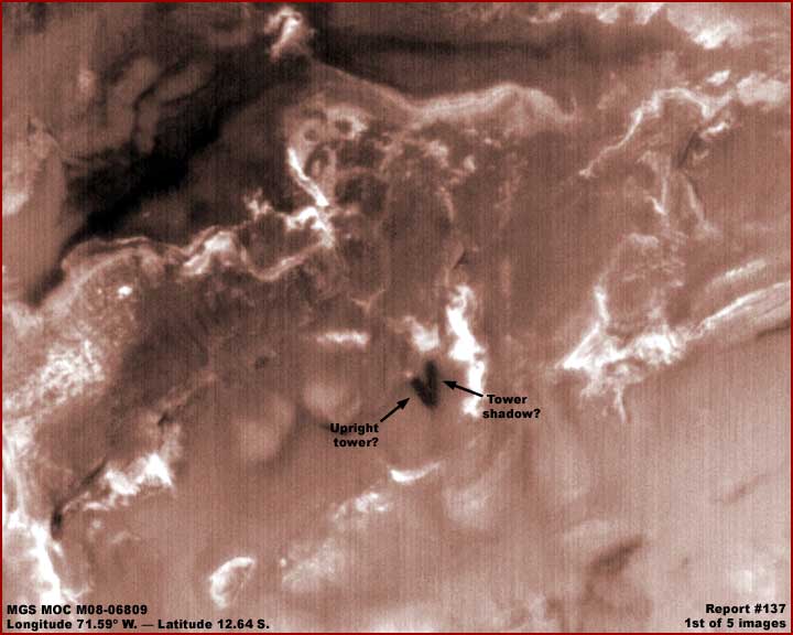
In the above first report image, you see black arrows and text pointing out what very clearly appears to be a dark tower of some kind with a bright light reflective top and casting a dark shadow on the ground just to the right and back of it. Note how the shadow length and width very closely approximates the tower size and radiates out from the tower base. Now please understand that this evidence is in a wide-angle image MGS MOC M08-06809 strip rather than the usual narrow-angle strip. Further, it has been flipped vertically by me here to provide a more comfortable view but this does not distort the evidence.
A wide versus narrow strip knowledge is important because narrow-angle strips offer a closer view while the wide-angle strips offer only a distant generally poorer resolution regional view. That means that objects in wide-angle strips to be seen at all must be really large and massive. That means that this tower appearing object would of course have to be very massive to be seen this well. On the other hand, it also means that closer examination of this object in this kind of poorer resolution wide-angle imaging is just not going to happen with any reasonable success of providing more detail.
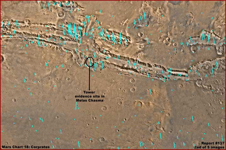
The above second image is the MGS Mars Chart 18 demonstrating with labeling the location of the evidence down in Melas Chasma. As you can see by the above, this location is in the center and bottom area of the great Valles Marineris canyon/crack system on Mars. It is generally the deepest known such system and the Melas Chasma is the deepest part of it . That means that this evidence is deep down well below the normal terrain level that surrounds the crack system by roughly about 11 kilometers or 6.84 miles.
In hoping that this will not disappoint you too much, I can tell you ahead of time that the upright tower looking object is an illusion and not real. The first tip-off is that this evidence looking exactly like this without change appears in all the following MGS MOC image strips but just remember that the tower looking evidence is only in the companion wide-angle context image on the right and not any of the narrow-angle strips on the left.
M02-00834 ..... 06/09/1999
M03-00945 ..... 07/05/1999
M07-04597 ..... 09/24/1999
M08-06808 ..... 10/27/1999 (used for first image here)
M14-00804 ..... 04/12/2000
M14-01375 ..... 04/19/2000
E02-01261 ...... 03/15/2001
E04-02161 ...... 05/27/2001
E10-02716 ...... 11/18/2001 (narrow-angle strip just nicked the base of the
"shadow" area but not shown here)
E17-00681 ...... 06/10/2002
E20-01605 ...... 09/28/2002
R12-01941 ...... 12/17/2003
R13-01433 ...... 01/09/2004 (narrow-angle strip used for 3rd, 4th and 5th
images here)
S06-00427 ...... 05/05/2005
S08-01660 ...... 07/15/2005
As you can see, at the very least, the shadow would have to have moved in some of these images taken at so many different times and conditions but it didn't. That fact right off clearly demonstrates that the shadow is not really a shadow and with all the implications for the "tower" evidence.
On an even wider scale, the whole Valles Marineris system stretched out from east to west is located just barely below the Mars equator line. Now up above or north of the Valles Marineris system and west/left wrapping around the west end of the Valles Marineris system and extending back north almost to the North Polar Region (not shown here) is the large Mars Tharsis volcanic region extending across part of the southern hemisphere up through the northern hemisphere and up near the North Polar region.
Parts of this huge volcanic area have formed into the highest elevation volcanic geological dome system known in the Solar System. The general dome is about 10 kilometers or 6.2 miles high. The largest of several volcanos sitting on this dome is Olympus Mons at about 24 kilometers or 15 miles high. There will no doubt be plenty of disagreement about this but I suspect that the rising and displacement of this much land mass to such incredible heights put too much stretching and undermining stress along some pre-existing fault lines located in the Valles Marineris system area resulting in its tearing and formation deep into the planetary surface.
Once formed into such incredible depths, this colossal crack would have drained any underground water eventually into the Valles Marineris depths. Likewise, as the volcanic region heaved upward over time, any large nearby surface water bodies all the way up into the North Polar region would have been displaced and concentrated east (right) and some could be expected to drain into the crack. This likely happened more so on the east/right side of the crack and extending up into the North Polar region. So, if water was present to begin with, the Valles Marineris system would have logically been a place of water in varying degrees at varying times in its overall history. It is even possible that it could have been intentionally engineered to this end but we will not get into that speculation here.
Okay, so much for some brief geology, now let's talk a little about life in association with this deep crack system. With dizzying drops, deep depths, and unstable shifting geology over time, Valles Marineris isn't exactly a friendly place for extensive successful vegetation to flourish and it doesn't. Even so, life unfamiliar to our Earth experience does flourish there and you should be aware of it.
On Mars there are a number of life species unknown to us here on Earth that take advantage of shallow water situations but not deeper pooling water. One of the most visible is what I have identified as "ridge forms" because they form into fields of many parallel side-by-side rows on slopes oriented downhill in the direction of shallow water flow. This is the more permanent and prevalent situation but less often they can also form into very sloppy parallel rows when water flow is not reliably consistent. They can also form into raggedly circular or hexagonal closed loop ridge formations trying to trap even more unreliable water flows or where water tends to pool in a shallow way on more level terrain and when this particular circumstance is prevalent for long periods of time. For some more exposure to the ridge form evidence take a look at my Report #001, Report #018, and Report #096.
Another different looking but likely a similar variety of this life visually develops into many long ropey looking strands. They exist where slower moving surface water flow consistently falls from a specific exit point in heights over cliffs in a free-fall like a waterfall. The slope under the waterfall is too steep for the ridge forms to develop on it but the base organism is still present in the water.
The net result is that the look is of a "frozen hard waterfall" but with a many ropy strands look starting a the exit point in the heights and then widening out further below. These formations can extend down to and contact the terrain below. Except for the hard fixed ropy strand look and the lack of very much build-up at the base area, this tends to look similar to but not the same as Alluvial fan formations of water and waterfall carried sediment here on Earth. This Earth evidence piles up on lower terrain levels as water comes down from heights piling up sediment at the base area building it higher and higher against the cliff wall.
However, on Mars, the key factor other than the long ropey strands is that many of these frozen waterfall formations never actually reach the lower level terrain and their bottom areas hang suspended in the air quickly identifying them as something very different than Alluvial fan formations here on Earth. For some more exposure to the Mars frozen waterfall evidence take a look at my older Report #050 and Report #096.
In any case, shallow water coming down from heights via slopes or via free-fall drops are necessary to these paraticular living formations and the Mars Valles Marineris system is the perfect place for them to form because it has great heights, vast numbers of varying angle slopes, and water traveling from the heights into the depths. As it turns out, the crack system has the highest concentrated numbers of this life on the planet. The crack is full of massive numbers of the "ridge form" sites and so many of them are incredibly large and extensive because of the long term stability of the water flow presence.
There are also the highest number of "frozen hard waterfalls" in the crack system as well. However, they are much less plentiful as compared with the ridge form evidence because their presence is dependent on more specialized conditions such a near vertical cliffs walls with consistent free falling water falling down from the originating heights. They are present in this strip but are very distantly imaged and so I have not shown them here.
Much less common but present are incredibly large formations of dark living substance that tends to either form in great massive rolling hills or wave looking formations or engulf large geological formations and tending in part to take on that underlying formation look. When many are present adjacent to each other but sort of spread out, they tend to look a little something like a number of sand dunes. When they tend to form in a tightly defined area rather than sprawling out in a wider area, this can look like a very strange object not resembling dunes and in fact nothing familiar to we Earth humans.
This life can get to incredibly massive sizes and I suspect it is kin in some way to the ridge forms and frozen waterfall life. Since Mars is officially not suppose to have much life of any kind large or small, the flawed default official explanation is "dunes" but they aren't that at all. So why am I talking about all this? Because this last mentioned type of huge life formation in a more tightly confined space is what has formed the illusion of the tower looking object and its shadow as you will see below.
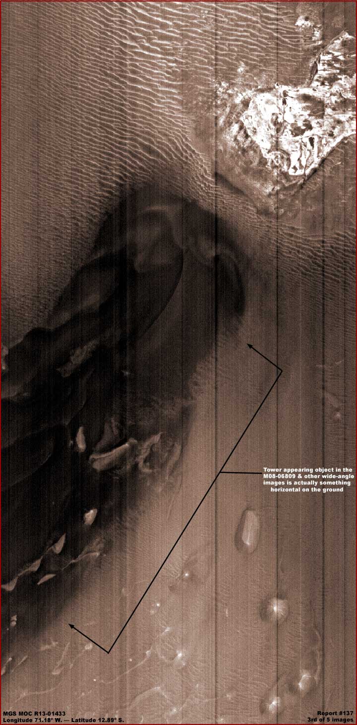
The above third image demonstrates the only decent narrow-angle image (R13-01433) of the "tower" looking object in the MGS MOC data that I know of. Even then it is only part of one "V" leg of the object and none of the "shadow" area is shown. The bright reflective terrain area just off the end of the object in the above image is what was giving the illusion of a light reflective top on the "tower."
As you can see, this is not an upright formation but something horizontal on the ground and it is surrounded by "ridge form" evidence with several slightly different appearances. Now the view above is from one side of the official science data strip to the other. The official statistics say that this distance is 2.99 kilometers or 1.86 miles. Because of the small size of the frozen waterfall in this strip and the size of the object in the wide-angle strip, I must tell you straight up that I do not trust these stated stats. I suspect that this view is much more distant than the official stats and therefore the object is much larger than this but you will have to arrive at your own opinion as to this.
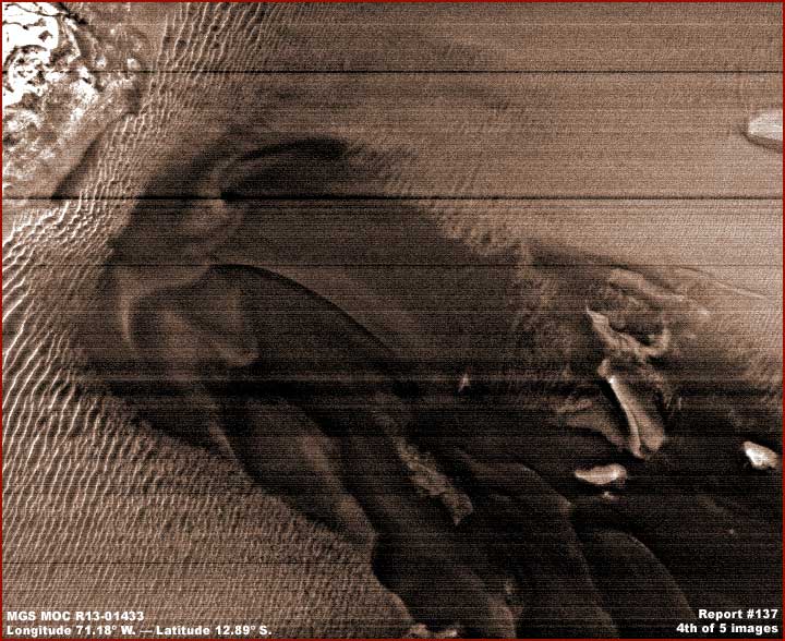
The above fourth image is of the same object but here rotated 90º counter clockwise giving a different view perspective. This view tends to make this object a little more natural and geological looking but, in my opinion, it is life of some unknown kind. As huge as this strange looking mass is to be seen at all in the wide-angle imaging as per the first image above, it is only of relatively middling size and broken up a bit compared to other more massive and uniform formations that are in more open terrain where they apparently prefer to be more in the sunlight. This one and any others like it has probably become trapped deep down in the Melas Chasma depths.
Note the many parallel ridge forms that surround this object in a great field of smaller and larger ones. They are usually always oriented along the slope plain. Note the larger better defined ones on the left versus those on the right. That likely means that this view is probably the more accurate one and that this huge formation is lying across and blocking a downhill slope here. Where the water can flow more freely down slope in the field of ridge forms to the left end of the object, there are doing better and are larger or better defined. Where the water flow down slope is interrupted and possibly partially absorbed by the massive object and to its right, the ridge form field does not do as well. Also the slope grade is probably less there as well and contributing to this.
I suspect that the massive object is some kind of strange unknown dark color colony life that has engulfed some underlying elevated geology in this spot giving it this partially broken up rolling wave appearance but still compacted and tightly defined and confined to the original material below it. However, ever how much of this you may be able to accept, the bottom line is that this is what the tower looking object and its shadow really looks like and the tower appearance in the wide-angle imaging is just an illusion.
This will likely not set well with some who have reported on this as a tower discovery. This is actually one of the first discoveries that came to my attention shortly after the MGS MOC data was released back in year 2000 and is not my personal first discovery but someone else's. I elected not to report on it over the years because I knew that I would be stepping on the toes of others who promoted this. I knew this was not a tower but did not know what it might be back then and so kept quite.
However, over the years this evidence keeps being brought to my attention and it always requires a lot of time and explanation or people tend to get upset. So I've decided to go ahead and address this in a report and hopefully this will take care of some future explaining that I may not now have to do. On the other hand, the fifth and last image below demonstrates that the exploration of the R13-01433 narrow-angle strip to produce the third and fourth images does have more to offer than just this great inexplicable dark massive object.
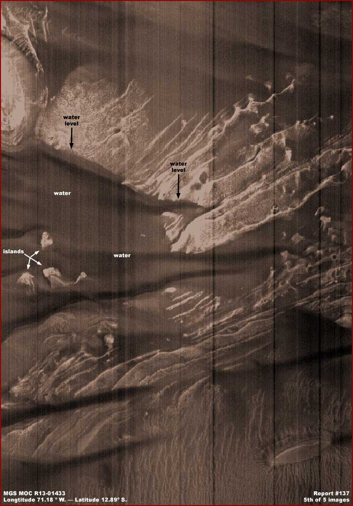
The above fifth image demonstrates a fairly recognizable water site in this same R13-01433 strip. In my opinion, this isn't the easiest to recognize and normally I wouldn't report on it because of that. Most of the time I pass on over water evidence of this quality for reporting but it's in this strip I'm reporting on and I think that many of you will be able to recognize it here.
The problem here with this water site is that the water is both uniformly shallow, clear, and still with no surface light reflectivity. That means that the underwater bottom forms are clearly visible like looking through clear glass and more visibly prominent than the covering water medium itself. In fact, if it were not for the water levels and lines clearly demonstrated on the exposed land surfaces in the upper/back part of the image pointed out by the black arrows and text confirmed by the waterlines on the small islands, I would not have reported on this at all giving it up as too difficult for too many viewers to recognize as I often do with evidence.
As for me personally, I have learned long ago that the presence of a large field of all parallel oriented ridge forms means that shallow water is present whether it can be seen or not and that their orientation means the presence and direction of a slope. The more well defined pronounced and rigid their orientation, the more rigidly formed are the ridge forms. Likewise, the more slightly sloppy the orientation as you see above in the bottom right area of the fifth image, the less acute the angle of the slope. They do not do well and are inhibited in their development when the terrain becomes more level and the water tends to pool too deeply. However, the presence of the ridge forms means to look for water and hope that the ever present obfuscation tactics haven't compromised its appearance too much.
Since a lot of water site presence could be expected to be drained down and absorbed in the deep crack system over time, one might also expect the obfuscation image tampering factor (if one can accept its existence at all) to also be higher in the images associated with the Valles Marineris system depths and so it is and most often very effective. Also, because of these depths and further away from the camera as well as many different chaotic terrain angle extremes present, the view is often poorer further complicating the view of evidence. So evidence of any kind down in these depths for a number of different reasons is often compromised even more so than up on the normal terrain levels.
When I first accessed this R13-01433 strip at MSSS, not even one of the browser compatible .JPEG or .GIF format images were available. This caused me to have to go to the proprietary raw .IMQ science data strip and convert it via the NASAview program to a .GIF image and something that PhotoShop can work with to get the 3–5 images hefre. As a raw unprocessed strip, it has not been destripped and you can see those stripes in the 3–5 images here. I elected not to eliminate them here in order to keep the information here as original as possible to insure no alternation of the evidence by me.
Since then, the .JPEG strip at MSSS has returned and is available. The same is also available at USGS and in some ways is superior. However, while these .JPEG strips look great on the surface for scroll down and examining its content for verification, they degrade quickly in trying to further clarify it and doesn't produce images for presentation here as good as the ones you see above even with their many flaws.
If you do jump through the hoops with the .IMQ raw science data image, you will find it so dark that little will be recognizable in it. This means that much clarifying work via a graphics software program will have to be done in the image to reach an acceptable viewing level as presented here.
DOCUMENTATION
http://www.msss.com/mocf_gallery/m07_m12/images/M08/M0806808.html: This link takes you to the MGS MOC M08-06809 official wide-angle strip on the right that my above first report image was taken from. Note that it is just one of the many listed at the beginning of this report with the tower looking object in them and not particularly remarkable over the others available except that the object in question tends to be more centered in the image and suitable for presentation. Note also that the official images will offer a different view of the tower object evidence relative to first vertically flipped image.
http://www.msss.com/moc_gallery/m07_m12/mc18.html: This link takes you to the MGS MOC Mars Chart 18 that is the source for my report second image.
http://www.msss.com/moc_gallery/r10_r15/images/R13/R1301433.html: This link takes you to the MGS MOC R13-01433 official narrow-angle strip on the left that my above 3rd, 4th and 5th images were taken from. Only the browser compatible straight .JPEG strip works for the larger than tiled view. The raw .IMQ strip is very dark rendering not much of anything identifiable and so quite a bit of graphics work will be required to bring in some clarity in working with that strip.
http://ida.wr.usgs.gov/html/r13014/r1301433.html: This link takes you to the same MGS MOC R13-01433 official narrow-angle strip and the browser compatible .JPEG strip is available there and it has the advantage of being able to view it in sections at a time. No .GIF strip is available and the raw .IMQ strip is the same as at MSSS.
, Investigator
![]()