
MARS GLASS TUBES, ET AL
Report #096
November 21, 2005
Recently I have been receiving some e-mail expressing an assumption that I may support the concept of "glass tubes" on Mars apparently confusing me up with others promoting this concept and/or confusing my earliest version comments in my very first Report #001. So, once again I'm going to try and explain my position on this as well as cover a some other evidence associated with this subject matter.
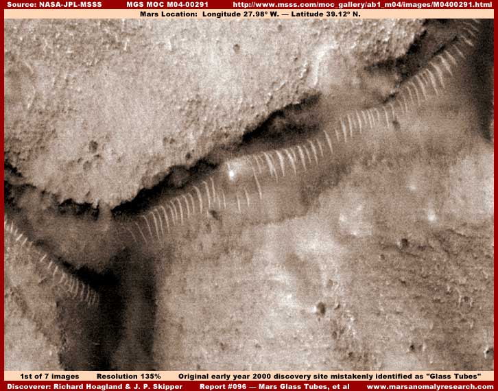
Back in early year 2000, the very first MGS MOC science data was wrongly being held back from release to the public and I was part of an ultimately successful effort to correct this via public pressure applied to some congressional leaders. When the data was finally released, I found the above first M04-00291 image evidence buried among other much lesser quality evidence at Richard Hoagland's website where, in my opinion, they were doing nothing with it. In my naiveté of that earlier time, I strangely couldn't seem to influence them do more with it either at their website or in the media.
Finally, getting fed up with this, I took the evidence alone into the media and kept pushing it until it eventually caught on. Once Hoagland and company saw what I was doing with this evidence, they quickly altered course and gave this evidence more prominent exposure at their website but also espousing the high drama and controversial website traffic building concept that these were glass tubes. At that earlier time, I had no graphics software expertise of my own and relied on the imaging and to some extent the interpretation of this evidence by others, including Hoagland and company. So, in my naiveté, I to mentioned their interpretations in my initial media piece under the misguided concept that such people had much more insight than I did in planetary research and so I mistakenly deferred too much to their judgment and characterizations of this evidence in some of my own early comments.
However, after the initial push of getting this evidence out there, questions kept coming at me from the public that I wouldn't answer without more and better personal careful observation of the evidence that I apparently intuitively knew that I should not trust to others. So, a short time later, I secured my own PhotoShop graphics software program and began to examine Mars evidence much closer including the then increasingly famous "glass tubes" evidence.
What I soon discovered is that this evidence wasn't remotely glass tubes or anything like that. One thing that I soon became certain of back then, and all my research in tens of thousands of images since then over the next five years has all reinforced this interpretation, is that the evidence you see above and just about all like it is something on the terrain surface representing life of some kind. Life that spreads and covers downhill surface slopes or grades enabled there by the presence of shallow water flowing down such slopes and then terminating in pooling catch basins at the bottom. At the bottom the ridge forms extends right to the edge of but never extends voluntarily down into the deeper pooling water and only exists in the shallow slope water flow channeling it between the parallel ridges. The only exception to this is when the water level may temporarily rise in the catch basin covering a portion of the ridge forms.
When the depression side slopes are relatively short from the top down to the bottom and the catch system length is long and narrow, then this parallel oriented "ridge form" evidence field is also long and narrow and more uniform in appearance and ridge spacing. When this evidence is seen in this particular set of circumstances, as in my above first image, it tends to visually resemble the long "tubes" interpretation in this distant poor satellite imaging in the quality it has been released to us. The smudge image tampering fields that are typically found around this type of evidence, such as also seen in the first image above, tends to reinforce this impression by smoothing the surrounding background providing the ridges with sharp contrast and also going up between the ridges smoothing out and destroying evidence there giving the ridges a even more pronounced and uniform look.
As soon as I determined what was really going on with this evidence, I quickly publicly backed off of the "glass tubes" interpretation and changed my original first Report #001 titled "The Real Smoking Gun as to Life on Mars" a number of times to reflect my own unique and growing interpretation of this evidence rather than bowing to someone else's. However, even after this, some around the world may still be attributing this glass tubes interpretation to me probably confusing me with Hoagland and company and arising out of the older media thing that was still circulating and so I came out with another Report #018 on 3/29/2001 titled "The Tubes: Natural Geology or Life?" trying to add insight and disassociate myself from this misdirection. Now here I am again in this report trying to get across that the sensationalized "glass tubes" and sometimes "worms" interpretation should not be associated with me nor any questionable agendas associated with this attempt at misdirection by others.
Now this isn't to say that there is no such thing as tubes on Mars. In my Report #035 titled "Buried Tube System," the evidence demonstrates a huge glass like buried underground tube system with the covering topsoil pulled back exposing a section of the top of the tube probably serving much like a skylight to the interior. Then there is my Report #037 titled "More South Polar Cap Civilization Evidence" demonstrating a distantly seen entirely above ground translucent very long tube system. Then take a look at my Report #045 titled "The Real Tubes on Mars: Part 1" and Report #046 titled "The Real Tubes on Mars: Part II" both demonstrating incredible but different colossal size tube systems on the Mars surface. Note that all this reporting is on smooth surface evidence without any surface ridges.
My point in referring here to all this older discovery evidence of mine in the preceding links is that there is some excellent evidence of very real and obvious tube systems on Mars. So, one doesn't have to struggle with debate about any misdirection interpretation of the "glass" tubes evidence to be something that it isn't.
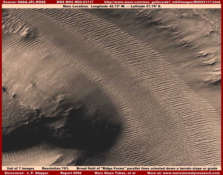
Now the above second image here from a different M00-03117 official science data image strip demonstrates what this kind of "ridge form" evidence can look like when a much bigger valley downhill (right to left) slope or grade is longer, broader and much more extensive. Looks a lot less like a tube of any kind and more like a terrain surface condition doesn't it. Here again there is smooth smudge image tampering fields bordering both the upper (right) and lower (left) terrain level ends tending to frame this evidence and contrasting it sharply. The tampering applications also extend up between the ridges making them appear even more pronounced but this can't be readily seen in this distant view where I tried to back off and encompass as much of this very large ridge form field as I could from one side edge of the strip to the other.
This type of ridge form evidence is typical of larger valleys where the potential slope or downhill grade and attendant shallow water flow (when present) is much wider covering a larger area. The direction of the many parallel ridge forms indicate the direction of the shallow water flow downhill and in this above second image that is from right to left through the ridge form field. When covering larger areas like this, the parallel line orientation uniformity also tends to break up a little becoming just a little more irregular with new lines starting in between older ones on down the line further dividing the channeled flow.
A few important points need to be made here. Note that the parallel ridges and their careful uniform placement is designed not to block or impede the down slope water flow but channel and maximize prolonged contact with it. Also, these are clearly elevated ridge forms and they are formed into place rather than erosion channels carved into the underlaying sediment layer. Water as a resource is the key factor here. Something is husbanding and preserving this resource in these specialized conditions and maximizing its effect. Further, what ever is doing this builds above ground and above the water line out in the air elevated forms to do so.
These factors likely indicate another factor of intentional design, intelligence and therefore active intelligent life as opposed to simple biological life reacting to the presence of this water resource or simple geological activity either for that matter. If only the distancing poor quality imaging and the outright image tampering wasn't so effective in obscuring this evidence, we could then have some better answers..
Also, it should be noted that these formations also initially form consistent with earlier water table and flow levels which may or may not be the same as current lower water levels. So, these ridge forms and their development can tend to follow the water flow levels down the slope as the general underground water table diminishes. This means that the ones at the very top of the slope may no longer represent viable life evidence and may just be very durable forms that last in the terrain long after the higher water level that enabled their development is gone. In such a scenario, the lower level ridge forms are likely the newest and most viable if any shallow flowing water is still present at all at the site or all may be defunct if water is no longer there.
Unfortunately, because of the very distant view and often poor quality of the imaging released to us, the shallow water presence cannot be directly seen in this kind of satellite evidence. In a few rare instances, the liquid water in the catch system at the bottom of a slope can be reasonably seen allowing a decent interpretation of this evidence. But, by far most of the time the catch basin water's presence is obscured by the smudge image tampering as is the case in the above second image here in this report. However, the very presence of the featureless smudge image tampering, once recognized for what it is, tells its own tale offering its own insight.
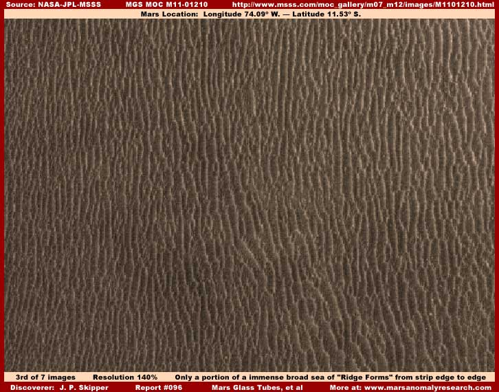
Sometimes, as represented in the above different M11-01210 based third image evidence, the ridge form evidence can develop over an even larger area completely covering all or just about all natural geology in the topography. Note the darker light absorbing quality and lack of reflectivity of this evidence. I had to lighten it considerably to provide the above view. The general darkness is because each narrow row line you see above has a reflective top surface but each is a very narrow top elevated form and, as such, it casts a shadow in the lower level space between the ridge form rows and the accumulated width of these many broader darker shadow across from ridge to ridge is greater than the more narrow reflective top surfaces. The net effect is that the entire ridge form field absorbs more light than it reflects.
The sheer collective size of this particular field, almost like a sea, probably indicates that the water conditions enabling the ridge development in this location has existed here for a very long period of time allowing the accumulation of this type of evidence to massive wide spread size. The view here is quite distant and that minimizes being able to see any normal size anomalous evidence that might be present in the space between the ridges and so there isn't very much smudge image tampering extending up between the ridges. This gives this field of ridge forms a bit different overall look than in the previous two images but it is the same evidence.
This evidence is located in Corprates Chasma which is the super huge and deep rift or crack system on Mars. So it would be logical to expect to find that very long and deep multiple level slopes are common topography in this colossal system. Likewise, it would not be surprising to find that ground water would also be draining into these deep Chasmas from surrounding regions.
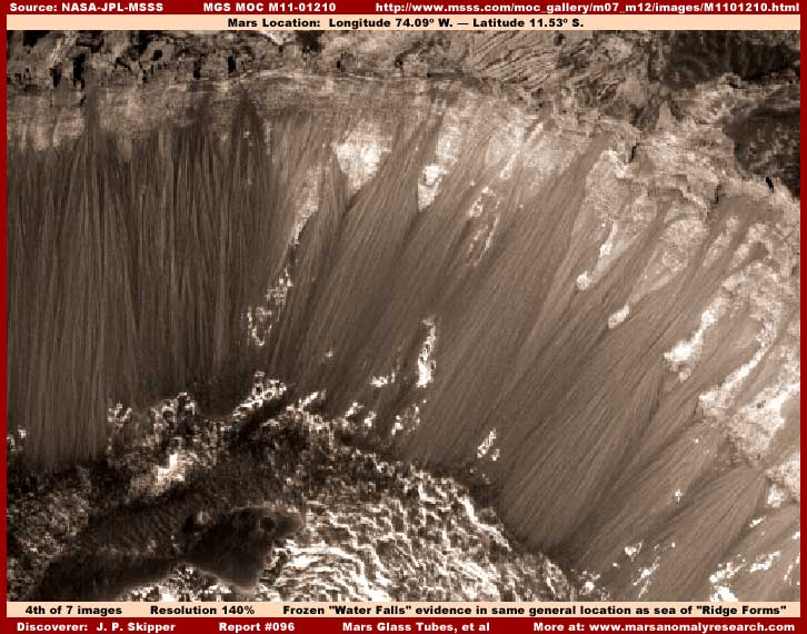
The above fourth image is also from the same M11-01210 strip as the third image here and this evidence site is located in the strip just above the dark sea of ridge forms shown in the third image. What this particular site represents is a steeper cliff like drop from an upper level in the top of this image to a lower level at the bottom of the image.
I've reported on this type of evidence before in my Report #050 titled "Colossal Waterfalls Turned Solid." My characterization of this evidence as a type of "waterfall" is because of course it is what it looks like and that interpretation is even basically correct. However, these aren't necessarily waterfalls in the classic sense we think of them here on Earth. Water here was originally free falling from a height into a lowland area but, like the shallow water flowing between and down the length of the ridge form evidence, the view here is too distant and poor for us to see any free falling water in this Mars scene. What we can see, like the ridge forms, is what its presence has enabled to form here in huge size at this site.
As the water falls over the cliff edge, it may be that some heavily present mineral compound in the water, such as calcium carbonate does here on Earth in water dripping down from cave ceilings, builds up layer by layer the long ropey hanging strands you see here forming from the top down. However, if this geological only explanation fit that closely the Earth cave environment scenario, then we should see some kind of equivalent stalagmite formation forming from the bottom up at the base of this cliff system. Yet, please note that there is absolutely no buildup at the bottom of the falls forming from the bottom up here. Further, if you looked at the same type of evidence in the above linked Report #050 and its closer imaging, just like in this image you can see that the huge ropey strands do not seem to quite make contact with the ground base area, must less build up on it.
So, does this last visual evidence factor necessarily rule out a non life geological explanation of percolating out mineralized water? The answer is no, if you are willing to at least consider an intentional artificial intervention concept. What if opportunistic civilized life obsessed with the presence of water occupied the base area of this cliff system living in and around its flow maintained the base area of the great columns keeping the bottom trailing stalactites ends free of building up at the all important bottom real-estate area?
In my opinion, very close examination of what at first glance appears to just be the rocky base area of the cliff system here in this image reveals a lot of very suggestive taller multilevel geometric structure detail mostly obscured by image tampering that doesn't quite hide it all. It was the same in some of the older Report #050 waterfall evidence. But, that's not quite all. You should be aware that, in my opinion, the MGS MOC imaging is full of universal very effective sweep type smudge image tampering of the vertical and base areas of bluff and cliff systems, steep land slopes down into basins, the sloping side surfaces of mounts, and the side wall surfaces within the interior of craters. The presence of all this wholesale image tampering on all this type of sloping terrain has plenty of implication and tells its own story.
But, that isn't quite all either. There is another possibility. It is entirely possible that the long ropey look strand or streamer evidence in these great mostly vertical waterfall columns is the same life evidence as represented by the ridge forms, just adapted to these special more vertical waterfall conditions and thereby looking different in its formation. It may be that what we are looking at with the waterfalls is the same long line of ridge form life building up around and channeling the downward water flow just as it does in the more gentle sloping terrain setting?
Now I must tell you that, even though I suspect it is the more probable explanation, I am a bit more uncertain about this last possibility of the waterfall evidence. Why? Well because I am not sure that what I've called "ridge form" evidence is not artificial structure and therefore civilized life itself. Sometimes inadequate tampering reveals what appears to be ridge form evidence but which tends to resolve into geometric structure evidence in rows and lines as I've occasionally reported on. The distance and poor imaging usually severely interferes with close examination and therefore proper interpretation. Further, I've discovered that various image tampering techniques are often at work in this type of evidence compromising its truth.
For example, take a look at the evidence in my Report #055 titled "Towers in the Sun." This evidence at first looked strange and meaningless until the obscuring techniques were understood and defeated. What at first looked like long continuous lines of something strange and unrecognizable all merged together turned out to actually be individually identified spire type tower geometric structure evidence in long lines. Only the fact that a slightly closer view of this particular evidence was mistakenly provided depending only on twisting the evidence of out correct orientation to obscure it allowed one to figure out what was going on and bring it back into correct perspective and thereby into a measure of truth.
Most of the similar ridge form evidence is intentionally far more distantly seen and does not allow that kind of closer inspection. Further, it it often heavily tampered with and it is nothing for the tampering software to color in a bright reflective or dark surface down the length of a line of structures producing the look of a merging continuous ridge form line of what may actually be individual objects. So I am hesitant to take a firm general position on the ridge form evidence beyond my general opinion that it represents life of some kind, either natural biological or civilized, forming and spreading in an organized fashion on these slopes.
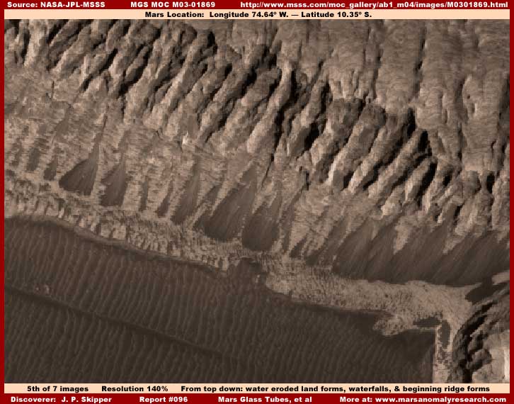
The above fifth image from the different M03-01869 strip is a poor distant view but it shows the presence of three important things together in one single image. First and second is the gullies eroded land forms in the top area of the image and the waterfall evidence right under them. For those who may want to try and convince you that the waterfall evidence is merely an alluvial fan shaped deposit similar to that seen here on Earth, here in the same image you can see what water erosion gulled land forms look like relative to the waterfall evidence and how different they clearly look and are. Also, don't forget that the waterfall evidence in the MGS MOC imaging, to the extent that I've seen it in many images, never builds up at the base area as would have to be the case if it were a true erosion alluvial deposit.
Third is the ridge form evidence in the bottom of this image and this is just the beginning of a colossal size field of this very pronounced evidence. Note that it is all very large in size and in organized parallel lines and all oriented in the same direction downhill on a tremendous slope in Melas Chasma extending deep down into the greater colossal rift/crack system on Mars known as Corprates Chasma. A huge amount of darker color ridge form evidence can be found within the great rift system and to a lesser extent the waterfall evidence and this is because the whole serves as a tremendous deep drain system down a great many levels and slopes. Since Corprates is very deep consisting of many different Chasmas and so many slopes and near vertical drops, it is understandable that a lot of upper level ground water can be found draining into this system from many hundreds of miles away in the larger surrounding regions.
One can only imagine what this deep rift Mars area might have been like when this great colossal crack was formed ages ago as at the very least underground water rushed into this then new crack system extending so deep into planet's surface mantle. Could it be that the evidence in my Report #059 titled "The Hand of Power" that can be identified only from approach in space is an artificial memorial of some kind to that stupendous event and its aftermath that is as much about water as anything else?
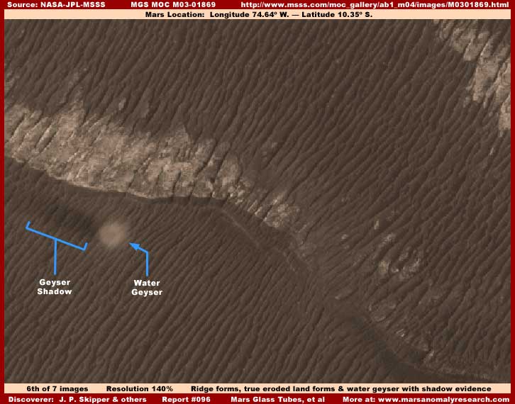
The above sixth image is a scene a little further down in the same M03-01869 strip. It is actually one of my first water discoveries that I found within just a few days of the MGS MOC science data initial release. I had been holding it back as a water discovery for inclusion in my upcoming book but others eventually found it which of course is the risk of sitting on evidence for too long. I think that a few have reported on it as a water discovery while most others have adopted the official party line identifying it as a dust devil.
The official identification is always that such evidence is a dust devil or dunes or the like in constantly pounding home the misdirection concept that Mars is dry as dust world devoid of life. While it may be true that Mars is a world that doesn't have great extensive surface areas water as a primarily water planet like Earth does, it is an irony that Mars is still a world the reverse of the official position with a great emphasis on water. The huge water geyser evidence pointed out by my blue arrows and text labeling in the above sixth image demonstrates this fact all too well. It also reinforces the concept of what this huge area of ridge forms is all about as well and that is water.
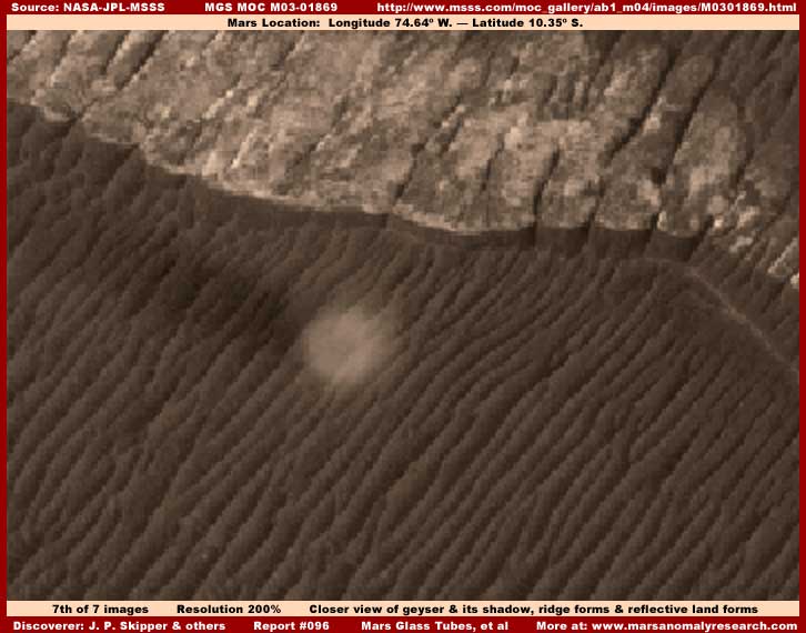
The above seventh and last image here is a closer view of the water geyser. Does this look like a dust devil to you? Does the many parallel elevated ridge forms clearly seen surrounding this object look like sand dunes to you or terrain topography surface that might support a dust devil? What you are really looking at is a huge stationary water geyser and its tremendous height is casting a faint shadow to its left. However, it should be noted that this ridge form evidence looks to me like it has been artificially coated with applications designed to give it a merged together look. As a result, natural top reflectivity and bottom shadow has been subdued and so the ridge form detail is too uniform and therefore not entirely trustworthy. The geyser itself has been left out of this tampering but its shadow has been partially subdued by the tampering applications on the ridge forms.
The very first discovery of liquid water on the surface of Mars actually happened in the 1970s Viking science data by Dr. Leonard J. Martin and it to was a water geyser. Check out my Report #052 titled "" to get a look at that water geyser for comparison. However, note that, in those Viking images, the terrain evidence around the geyser looks like it to has also been compromised by obscuring applications.
The problem is that the official position is that Mars is a freezing cold, dry as dust, and essentially a dead world. Such concepts are designed to dull the senses and interest in Mars detail and make Mars a safe world to contemplate without generating any suggestion of concern or anxiety. When one adopts such a arbitrary general position, one can't have inconvenient data indicating otherwise. So, not only are true dust devils identified as such, so to is anything else that might look remotely similar but is something else entirely.
Likewise, terrain with any kind of ripple or undulating pattern to its visual surface is misdirection identified as dune fields when it clearly isn't that, just as you can see above. This ridge form evidence is far too organized in its parallel non wandering patterns and specific placement to be so carelessly classified as having a natural geological sand and wind origination trying to pound home desperate misdirection mantra. Even pooling surface water itself is often officially identified as dark sand when it clearly demonstrates translucent quality and under water bottom forms are clearly seen under the surface.
SUMMARY
This report started off as an attempt on my part to bring better insight to what I call the "ridge form" evidence while at the same time also getting myself better disassociated from the "glass tubes" concept that some still want to associate me with. I'm not sure whether I succeeded at that or not after wandering all over the place some in this report. I sometimes forget that what I gradually begin to take for granted in my ongoing research, is relationship information across multiple evidence that isn't necessarily being adequately communicated by me to viewers of this anomalous evidence record.
The problem is that understanding the ridge form evidence better also means needing to better understand their close dependent relationship with shallow liquid surface water and the very strong possibility that this type of evidence may well represent active life itself, even if currently inadequately understood. Then again, since the waterfall evidence may also very well be the same as the ridge form evidence, just adapted to different water presence circumstance, one has to cover that a little as well. Also, if you're going to talk so much about a water presence that can't actually been visually seen, then why not throw in some more obvious water presence evidence in the form of a geyser large enough that it can be readily seen.
So, the net result is that this report winds up being about encompassing visually different looking evidence and showing a common thread relationship (water) and link between them that at first may not be readily apparent. It was much the same in my last Report #095 where liquid surface water discovery evidence in Aram Chaos crater catch basins was relatively obvious but its less obvious shallow water conditions presence and relationship to the ridge forms and suspicious mount evidence was also briefly explored.
So I'm trying to tie up some loose relationship ends here that will hopefully provide some measure of increased insight into a greater picture of some things happening on this distant world. The point being that, although all this science data is heavily manipulated to obscure truth and it is very effective in that regard, simple observation combined with some open mindedness and a little logic and reason still goes a long way in working out a little of this Mars truth.
If I have perhaps not adequately enough communicated the necessary insight into this type of evidence and its relationship with each other here in this short reporting style, I am sorry for that but at least basic awareness of the concepts has been raised. One day, when the hidden more detailed visual data existence is owned up to and released and/or the insiders eventually own up to some truth, we will all hopefully have better insight into this different than Earth water versus life dynamic on our sister planet Mars.
DOCUMENTATION
http://www.msss.com/moc_gallery/ab1_m04/images/M0400291.html: This link takes you to the M04-00291 official science data image that is the source of my first image in this report. As is too often the case in the MOC imaging, note that, if you use the third listed straight .GIF strip, it has been flipped both vertically and horizontally at official level and you will need to correct this in order to achieve the correct orientation represented in the first two images and as confirmed by the companion wide-angle M04-00292 context image. Also, once corrected, you should know that I rotated the evidence scene in my first image here 90º clockwise to achieve a more pleasing and informative view of the evidence.
http://www.msss.com/moc_gallery/ab1_m04/images/M0003117.html: This link takes you to the M00-03117 official science data image that is the source of my second image in this report. As is too often the case in the MOC imaging, note that, if you use the third listed straight .GIF strip, it has been flipped both vertically and horizontally at official level and you will need to correct this in order to achieve the correct orientation represented in the first two images and as confirmed by the companion wide-angle M00-03118 context image as well as to match my imaging.
http://www.msss.com/moc_gallery/m07_m12/images/M11/M1101210.html: This link takes you to the M11-01210 official science data image that is the source of my third and fourth images in this report. As is too often the case in the MOC imaging, note that, if you use the third listed straight .GIF strip, it has been flipped both vertically and horizontally at official level and you will need to correct this in order to achieve the correct orientation represented in the first two images and as confirmed by the companion wide-angle M11-01211 context image as well as to match my imaging.
http://www.msss.com/moc_gallery/ab1_m04/images/M0301869.html: This link takes you to the M03-01869 official science data image that is the source of my fifth, sixth, and seventh images in this report. As is too often the case in the MOC imaging, note that, if you use the third listed straight .GIF strip, it has been flipped both vertically and horizontally at official level and you will need to correct this in order to achieve the orientation matching the first two images. However, note that there is no companion wide-angle context image to confirm which orientation is correct. So, after comparing the available images, I used the third strip orientation "as is" because it definitely seemed more correct than the others.
, Investigator
![]()