
MARS STRANGE BIO-LIFE-1
Report #145
August 24, 2008
This report will examine evidence
that may be hard for some to grasp because it is so different and unfamiliar
relative to our Earth experience. That just can't be helped. After all, exploration
is all about new knowledge and forging ahead with new knowledge frontiers.
When strange and unfamiliar things falling too far outside the perceived norm
are first observed there is often an Earth human tendency to try to force
them to the more familiar like trying to force a square peg in a round hole
and/or just avoid them by dismissively labeling them as inexplicable. There
is nothing that is inexplicable, there is only the need to understand purpose.
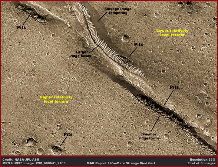
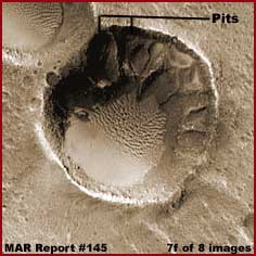
The above first image provides a distant wide-angle context view from one
side edge of the single MRO strip sourced here to the other side. Even though
this is a distant view, note how pitted the general terrain is. As you progress
in this reporting, the pitted nature of the terrain will be significant to
understanding the evidence, so pay some attention to it as you go through
the images. The black lines and labels point out the principle evidence in
this reporting and note that there are basically two different looking types
of evidence.
The most pronounced in the upper left portion of the image are parallel short
length rows of sunlight reflective ridges that I have previously reported
on and named "ridge forms." This evidence is more plentiful in the
northern and southern hemispheres but much less so in the northern and southern
polar regions suggesting that it is likely temperature sensitive. Its presence
is the most plentiful in the Mars great crack system just above the Mars equator.
This is understandable because the ridge form evidence is absolutely dependent
on the presence of shallow water and in a liquid state. When liquid shallow
water flows down a terrain slope reliably over an extended length of time,
these ridges form on that slope parallel to the direction of the water flow
and can develop into very large forms and formations such as you see in the
upper left portion of the above distant image. When the shallow water flow
is less consistent and reliable, they form in less well developed smaller
formations such as you see in the lower right portion of the image. This evidence
will not develop in deeper pooling water.
When the slope is shorter but lengthy along a long lateral narrow terrain
feature like a crack or rift, the look is as you see in the above image that
has so many times been mistaken for "tubes" by others and is still
being reported as such by them. However, when the slope is much longer and
with shallow water flow presence, the ridge forms will develop all over it
with extensive very wide area fields of coverage. In the various deep chasmas
on Mars like the great crack system, the great depths create many slopes with
water flows down many of these slopes and so it is understandable why this
ridge form looking evidence is also most prevalent and extensive in the various
chasmas.
The most pronounced look of the ridge forms is their parallel rows of ridges
feature. However, more subtle and usually more difficult to see in this poor
quality distant imaging is that many smaller parallel ridges form at a 90º
angle to the main parent ridge. This is to retard and likely filter the shallow
water flow in the troughs between the main larger parent ridges and these
secondary ridges will form as necessary to facilitate and/or retard water
flow. For some of my previous reporting on ridge form evidence similar to
the above evidence in more narrow formations, take a look at my year 2000
Report
#001 and year 2001 Report
#018. For my previous reporting on ridge form evidence over broader
wider fields, take a look at year 2005 Report
#096.
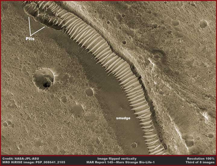
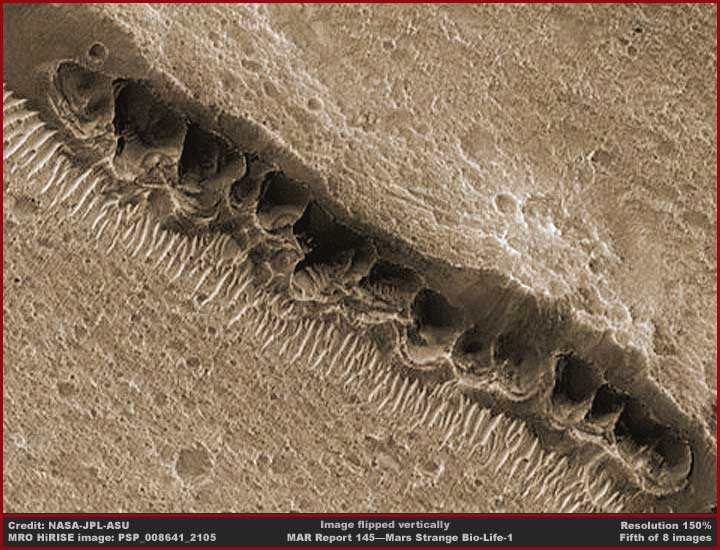
The above second image is a flipped
vertical view demonstrating a closer view of the largest ridge form evidence
in this strip. Note the presence of the smudge image tampering applications
as labeled. Note how the smudge actually penetrates up inside the ridge form
troughs on the left side of the formations. Such fine detail obfuscation work
is enable by the very high resolution of the MRO imaging but, as most of you
know, little of this kind of fine detail makes its way into the public release
images.
However, the ridge forms are not the only shape this evidence takes. The shape
this evidence takes is determined by type of water presence and what is required
to successfullyy adapt to it. When the need is present over long periods of
time, it should come as no surprise that life will adapt and fill the available
nitch.
Note also the two older pit formations pointed out by the labeling in the
upper left corner of the image. If the smudge had not covered the near side
of the pits, you would have been able to see that these are elevated formations
and not natural geological pits with their top rims level with the terrain.
That's why the smudge is there to obscure and create illusions. You can also
see smudge applications all throughout the terrain in many smaller individual
pits obscuring them. Why? Because we would otherwise be able to determine
that many of these are elevated formations rather than just sink in pits as
per the official explanation.
For example, when a slope is very steep and/or water is pouring in greater
volume over a ledge freefalling into depths below in what we would consider
a waterfall, this type of evidence can sometimes adapt and establish itself
within the flow providing the flow isn't too strong. In this case, many ropy
looking strands form down which the now shallow water is directed and they
widen out from a central core area into a widening fan shape going downward.
These often with distant views resemble alluvial fans here on Earth where
water with sediment in suspension within it falls as a waterfall over a cliff
edge. Here on Earth, if the distance down isn't too great, over time the water
carried solid sediments will pile up at the bottom and build up over time
back up to the waterfall's source on the cliff edge and this creates the "alluvial
fan" look.
However the Mars frozen waterfall looking evidence is not alluvial fans. Why?
Because with this Mars evidence the formations build from the top down much
like stalactites do in caves here on Earth. However, unlike stalactites and
alluvial fans, both of which are the function of simple straight forward geological
processes, this Mars evidence most often stops just short of the bottom area
and intentionally (demonstrating control) hangs in suspension there. Why?
Because controlling flowing shallow water across its surfaces is the key to
its life and survival adaptation and piling up in base areas doesn't facilitate
this. For examples of this type of evidence take a look at my year 2003 Report
#050 for an eye opener as to the base of one of the "frozen
waterfalls."
However, this reporting is not about frozen waterfalls or for that matter
very much about ridge forms either, except in passing. This reporting will
introduce you to yet another variation of this alien life form, the "pit
formations."
When water presence is not very much on the terrain surface but the water
table is fairly consistently plentiful not too far below the surface, a variation
of this life form digs down in the ground to access it. In the process a roughly
rounded but irregular pit shape is formed shored up along its elevated relatively
thin sides by this living material. That is what this reporting is mostly
about. In the above 1st image, please note the various distantly viewed "pit"
evidence pointed out with the linear lines and labeling.
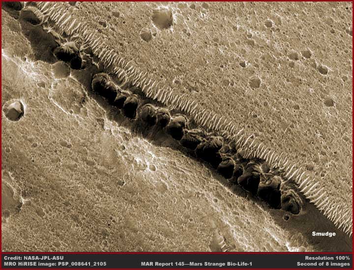
Now in the above second image representing
the official orientation view, note the long line of individual pits in what
appears to be a trough system. Now the official explanation
associated with this image found HERE
tells us that this is fault a line and that the pits are formed by surface
material falling down into underground voids along the fault line. Sounds
geological and reasonable doesn't it?
Note how the line of pits appear to be centered in the fault or trough system
facilitating this official explanation. However, this is an illusion created
by darker smudge image tampering applications all along both sides of the
line of pits giving the centered look. This image has also been flipped vertically
at official level to help create this look.
Further, note how pitted and porous looking the surrounding terrain is once
the scene has been cleared up a little to provide this level of detail. Looks
a lot like the surface of a sponge doesn't it. Likewise, take note of those
larger individual pits in the upper portion of the image. Note that most of
them have smudge image tampering applications covering most of their area.
The official position would have us believe that these are many small impact
craters but note that none of them have any signs of impact blast or ejecta
presence at all. That's because such statements in combination with the visual
obfuscation are designed to manipulate and bend perception away from truth.
The terrain looks like this because it is holding onto water below the surface
like a sponge and this life form whether big, medium size, small or tiny has
been digging and dying in this terrain for this water presence since ancient
times giving it this thoroughly pitted porous sponge look. The pit line is
just the by far largest and most obvious examples of this life form because
this lower trough system has more reliable water presence over a very long
period of time and so the evidence managing to survive over such long periods
has over time gotten very large as water presence increased and diminished
in this location.
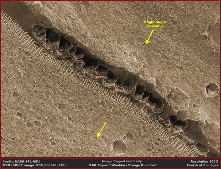
The above fourth and fifth images
are just the third image flipped vertically and the fifth image provides a
closer look at the pits. Note how the pits now appear to be closer to the
back edge of the trough and elevated despite the smudge applications. Of course
the flipping did not eliminate the smudge tampering. What it is hiding is
a slightly elevated raw cliff face and subduing the elevated thin rim wall
look of the pits. The pits are actually snuggled up against this cliff face
as elevated formations and that is what they didn't want us to see.
The only thing correct about the official explanation is the presence of the
fault line. It represents a division between slightly higher elevation terrain
in the upper right of these 4th and 5th images and slightly lower settled
terrain in the lower left. The fault line has created a short height drop
down cliff between the two terrain levels all along the length of the fault
line. Ground water flows into this fault location from the upper right terrain
but it is not a particularly strong flow and has at times been absent requiring
the life form to dig deeper in the fault.
Reliable water presence in the fault is the attraction for the pit formation
life to concentrate along the fault line. The sheer size of the pits suggests
that they have been in this particular location for a very long time and that
the water presence is fairly consistent and reliable over longer periods of
time even it there have been some lean times. The small size of the ridge
forms (relative to the huge ones in the second image) also present here suggest
that on occasion there is some water overflow that the big pits allow to get
past them but it isn't consistent enough to result in any significant spurt
of the larger ridge form development.
 ..
..  ..
.. 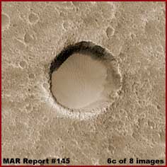
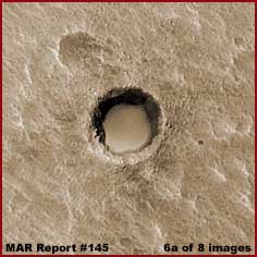
The above 6a–6c images demonstrate
some large holes in this strip's terrain that do have pooling flat level water
presence filling their bottoms. These are likely ancient in dryer time pits
that encountered too much water influx and the pit life presence is now long
gone because it cannot survive in formations discussed here in deeper pooling
water. Note the absence of any pits forming even at the hole edges to take
advantage of this water presence. That's because this life form cannot survive
immersed in deeper pooling liquid water. If I had enough image room here to
show you a much closer view of the holes of water, you would see the water
is actually ice as the time this image was taken.
Now pooling water in Mars holes or craters is often turned to ice. When the
ice in these holes is thick and not subject to too much periodic significant
melt, what ever this life form is (almost certainly colony life) gets into
the ice transforming it. A typical scenario will be that the ice starts showing
visual evidence of many parallel ridge form formations in it. The above two
6b center and 6c right images show hard to see faint evidence of this. Of
course water ice being very light color and very sunlight reflective tends
to wash out this visual detail. Even so, the Mars terrain is full of a great
many thousands of holes and craters full of water ice demonstrating this visual
ridge form transforming the look of the ice.
 ..
..  ..
.. 
 ..
..  ..
..
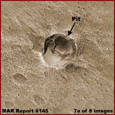
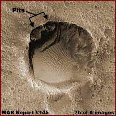
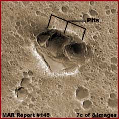
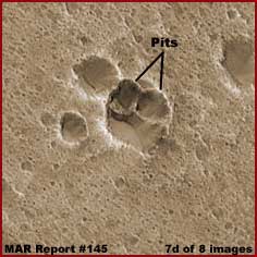
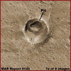
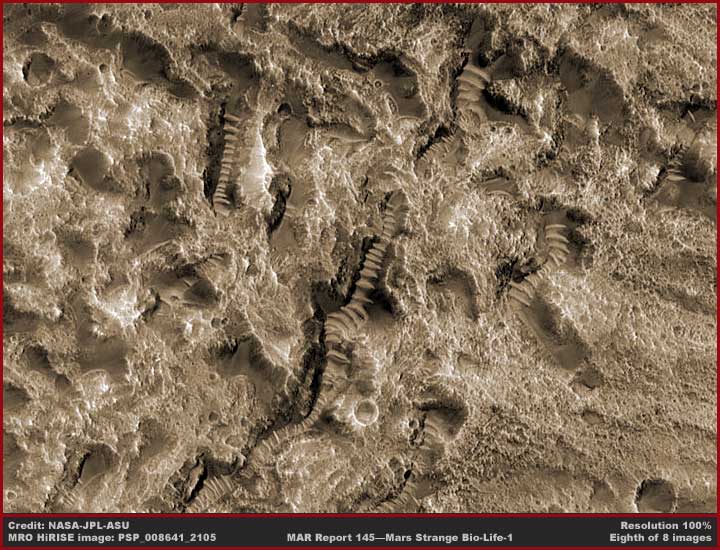
Now the above six 7a–7f images
demonstrate different samples of the pit formations trying to get going on
the edges of other holes elsewhere in this same strip. Note that three of
the images also demonstrates small lakes of water out in front of the holes
indicating that this is a time of probable plentiful water closer to the surface
in these particular areas. Note that the two 7b and 7f larger holes show evidence
of water ice in their bottoms with the ridge forms more clearly transforming
the water ice.
However, the main thing here is to note how the pit life forms on the slope
at the hole's top perimeter. Note how they are here seen as more elevated
formations with elevated rims and not just collapse sink holes level with
the terrain. You can bet that the original large hole was probably formed
in dryer times when ancient very large pit formations had to dig deeper and
deeper for lowering underground water levels and in the end dying and leaving
a raw deep hole as water levels increased too much for them. Obviously none
of these are impact craters as the official explanation would have us believe.
Although the evidence here of the large ancient pit formation has deteriorated
away leaving mostly only a raw hole, for the longest time, I would see single
so called "craters" in the Mars landscape that were officially passed
off as impact craters when they they inexplicably didn't look like that at
all. They had these same elevated but thin pit rims only much better formed
than the ones you see in the chain of pit formations here. What they really
appeared to be were what I now know to be these pit formations but on a older
and sometimes even larger scale.
Now these pit formations have obvious visual similarities with natural geological
pits and sink holes here on Earth and the secrecy agenda depends on the scientists,
academics and public making that mistake in interpreting them toward what
is the most familiar. Just in case that assumptive process isn't sufficient
to lead the average viewer astray, then the images are flipped distorting
the view and the elevated aspect of the evidence is subdued by smudge tampering
treatments.
For example, in each of the above six 7a–7f images, note that many smaller
pits in the terrain have smudge coatings on them so typical of all of this
strip's terrain. This is to destroy the elevated rim look of the evidence.
If one saw this terrain full of many different size pits looking for all the
world like "vase" sponges on a sea floor with elevated thin perimeter
rims on them, there is no way that these could be successfully characterized
as "impact crater pot marked" terrain and that misdirection explanation
be bought into even by too often clueless scientists and academics.
On the other hand, if every single pit or the holes with pits in them were
covered over by smudge, then the smudge treatments would be far to thick and
draw attention to themselves as image tampering. Thus the need to leave a
little of the least offensive evidence out which you see above. This is the
way obfuscation is done via part technology and part psychology.
The above eighth and last image shows
quite a few ridge forms developing in this rough terrain. Out of sight to
the far right is a very large impact crater very deep hole that significantly
influences the terrain in this scene. To the left is higher ground and to
the right is lower ground gradually sloping down to and over the edge of this
great hole.
Note that the ridge forms parallel orientation are all in the same direction
despite the fact that there are a number of different larger and smaller formations.
That is because shallow water, too little to be seen in this distant imaging
and most of it underground, is flowing both underground and across some of
the surfaces from left to right. Where the underground water surfaces temporarily
before going back in the ground, the ridge forms develop on short slopes taking
advantage of it.
There is also something less obvious here and which I will mention even though
I've devoted no imaging to it. To the left just out of sight is a ground hugging
wiry dense vegetation growth coating the rock rocky surfaces. Also, to the
right and a little visible in this image is another different wiry dense low
vegetation growth going down the gradual slope to the crater edge. None of
this vegetation growth is not easy to detect and so I did not waste any images
or reporting time on it except just to mention it.
A main reason for this reporting is to make sure you at least aware of the
consideration that the pit formations are in fact strange bio-life unique
to Mars as well as unfamiliar looking and alien looking to us. Another purpose
is to tie the pit formation evidence in with the ridge form and frozen waterfalls
evidence. Despite the dramatic difference in looks between them, they are
the same or nearly the same life and variations of each other. They all are
strange and all about shallow water presence and the need for adaptation to
that water presence is what dictates both their configuration and their look.
For some it will be too humanly tempting to pass this evidence off as geology
and something familiar rather than life and the secrecy types keeping pounding
the geology psychology home making this situation worse, so I'm going to hit
this again in my next report. There you'll see an even better look at the
strange reinforcing what you've seen here and in past reporting.
Again, exploration is about pushing back the frontiers of knowledge and that
in turn often pushes one's belief systems, especially rigid ones. Consequently
understanding rather than dismissal and avoidance requires considerable objectivity
and often thinking outside the box. That is the way it is with this evidence
but each of you must decide for yourself.
DOCUMENTATION
http://hirise.lpl.arizona.edu/PSP_008641_2105:
This link takes you to the MRO PSP_00861_2105
official science data image that is the sole source of my reporting here.
I used the second listed full grayscale non-map projected (straight) .jpg
image to make it easier for those of you who wish to check and verify behind
me that the JP2 imaging may not facilitate.
, Investigator
![]()