
MARS SOUTH POLE BIOLOGICAL
LIFE: PART 1
Report #085
March 27, 2005
This reporting isn't going to be easy. What I'm going to try to do here in this report is convey a sample of dense carpeting biological life evidence at the edge of the Mars South Polar Cap in spite of the image tampering trying and almost succeeding in confusing and obfuscating it as well as further evidence of seasonal water flooding conditions in this area. So this will be a report fairly equally spread over biological life and surface water evidence as well as the image tampering trying to hide it.
This attempt will require a larger than usual number of images. Further, the main evidence images will be characterized, despite substantial .JPEG compression for presentation here, by some of the largest image file sizes I've presented to date due to the amount of intricate detail in them. Therefore I'm going to divide this reporting up into Part I, Part II, and Part III to keep the file loading time within reason in each part. At the end of each part will be a link to the next part, so don't over look it.
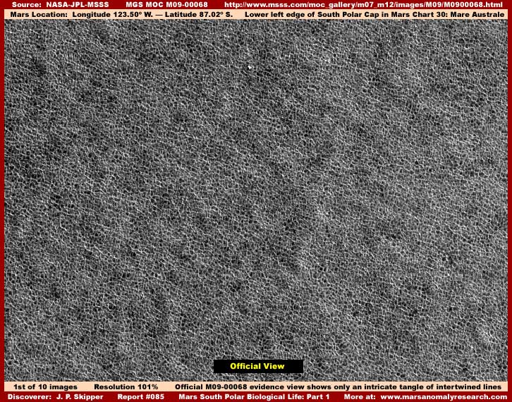
The above first image here represents the official view of just one of these evidence sites in narrow-angle strip M09-00068. As you can see it is a solid carpet of a strange tangle of meaningless mass that looks like intertwined lines. This massive solid carpeting evidence encompasses the entire strip from edge to edge. You can see this by visiting the official science data link for M09-00068 and here's another link at another strip M08-07281 just to show you another good example of this same type of edge to edge evidence on this particular Mars South Polar Cap peninsula location.
While you are at these linked sites, please also note that the evidence is basically the same and in the companion wide-angle context image on the right that each site is close to the other on this particular South Polar Cap peninsula. In fact, all the evidence presented here in this report is located on this one particular peninsula and in close proximity to each other.
Now I originally suspected that the evidence in the above first image represented an artificial image tampering geometric form pattern carpeting and covering something hidden under the pattern. I've encountered this before. Trying to understand this scene, I tried to find a repeat of the pattern to confirm this but, although the pattern is so intricate as to be a bit overwhelming in this regard, I gradually came to the conclusion that there was no repeat and that this may not be an artificial cover pattern after all. Once understood, logic dictated that this may be ground based reality but altered to appear as something meaningless. In other words, misdirection via illusion. That led of course to the suspicion that real evidence had been inverted at official level to appear as it does in the above official view.
I was now suspicious that what I was looking at was elevated rounded top objects with a distinct space between them creating a scene of densely packed but still individual objects. In the inverting process, the normally light color reflective elevated rounded shape is inverted into a downward bow of dark color essentially disappearing from view when each object is distantly seen and on a tiny scale like this. Also, in the inverting process, the dark shadow interspaces between the objects in shadow are accentuated in the inverting process to created the lighter color lines you see in the first image above.
I knew that biological life evidence as I've described above was possible from past experience such as evidenced in my Report #021 titled "Huge Fungi Growth in South Polar Region" presented back in 2001. Further, I knew about the inverting tampering tactic such as evidenced in previous Report #034 titled "The Well of Illusion" back in 2002 where tampering terrain surfaces were then disguised by inverting them. So I explored this as a possibility with the results as appears below.
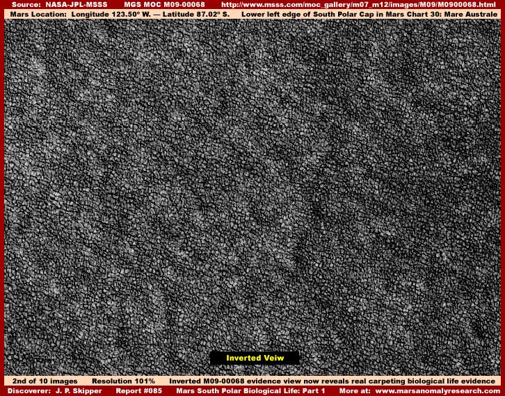
Now the above second image is the exact same scene as the above first official image view but now inverted by me. As you can see, the scene now looks entirely different and is filled with irregular individual objects that I'll call clumps for the lack of a better description. The intricate tangle of intertwined lines seen in the first image because they merge together so well cannot explain the abnormally large file size for this image. The abnormally large file size of the imaging is a clue to be suspicious and look much closer.
You see a forest of regular but densely packed tree tops here on Earth would not be seen and counted by the software as a great many individual hard objects because of the intertwining nature of the trees upper branches as seen from above mingling with each other creating a lot of merged look. That is the same principle here with these densely tangled lines. On the other hand, a great field of boulders for example with spaces and shadows between each boulder separating and identifying them as individual hard objects would be counted by the software individually and result in much larger image file sizes.
On that principal, the intricate tangle of intertwined lines you see in the first image above just couldn't adequately explain the large image file size that was so out of proportion to what was being seen demanded deeper examination. The result is that these packed super tight but still individually separated clumps/objects most definitely does. This is what the graphics software was seeing through the visual misdirection disguise and counting resulting in the huge file size. In other words, this was not a case of civilization evidence covered over by another pattern but true ground level terrain detail altered to create an illusion that appears as something else meaningless and less recognizable.
You will note that this looks very much like the same type of irregular shape but still uniformly geometric super tightly packed but still individually separated biological life evidence in past Report #021 at the link above, just much more distantly seen here over a much wider area regardless of the official scale statistics as posted. In other words, the first image above represents meaningless falsehood created at official level before release and the second inverted image here represents extraordinary Mars ground level biological life reality on this peninsula at the edge of the Mars South Polar Cap.
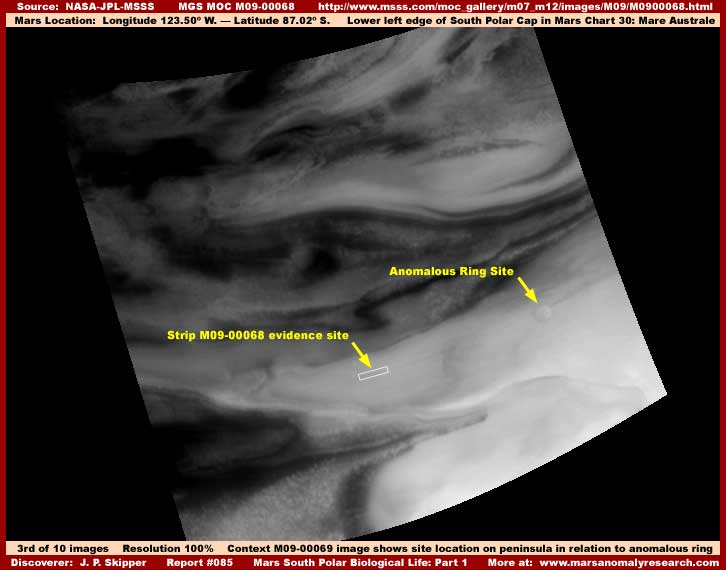
The above third image is the M9-00069 companion context wide-angle image view to the M09-00068 narrow-angle image. It demonstrates the location of the M09-00068 narrow-angle image evidence location on this peninsula and its nearby proximity to the Anomalous Ring evidence reported in Report #079 titled "Mars South Polar Ring Anomaly." Please note that the soft fluffy foggy texture you seen all over this peninsula is a solid covering of light color high albedo (reflectivity) smudge image tampering essentially obscuring and hiding all terrain level detail there. The only reason the round ring can be seen and identified at all here is because the tampering application was the mapping type that mapped around the ring contours as it covered it over continuing to reveal its presence, even if indirectly.
You should be aware that the portion of the peninsula to the left of and to the right of this evidence site up to the Anomalous Ring site is subject to seasonal flooding water cycles where much of this portion of the peninsula will be submerged to some degree. In this above third image, you will note that most of this peninsula appears to be exposed and so this image appears to have been taken during the dryer seasonal cycle where flooding liquid has receded exposing most of this peninsula. According to the official statistics, this image was taken on 11/1/1999. This beginning of November date appropriately confirms and places this scene getting near the end of the dryer cycle and approaching the beginning of the flooding cycle in late December and January.
If you are not up to date on this South Polar seasonal liquid water flooding cycle that I've reported on where you can recognize the presence of flood waters at this site and others like it, then take a look a Report #077 titled "Mars South Pole Flood Water" posted back near the end of 2004 of this same general area. Please do so because the next Part II and Part III of this report will show and have links to more context wide-angle image evidence of this seasonal South Polar water cycle in action at this location and you'll need to be able to learn to recognize this for what it is. Make no mistake about it, the dynamic flooding water evidence is just as important as the biological life evidence to understanding truth here.
Likewise, the carpeting biological life aspect of this report is certainly not the only such life evidence that I've reported on in this same area. Take a look at Report #082 titled "Mars Shoreline & Life Evidence," also very near this evidence site. The number of images in that report limited what I could show of the shoreline biological life evidence but the edges of some different but still densely packed carpeting biological life is clearly presented there and, if space had permitted, I would have shown much more extensive areas of it in more imaging.
Now with image file size space used up in this PART 1 report due to the abnormally large first and second image files here, let's move on to Part 2.
DOCUMENTATION: (for Part 1)
http://www.msss.com/moc_gallery/m07_m12/images/M09/M0900068.html: This links takes you to the official science data M09-00068 narrow-angle and M09-00069 context wide-angle image strips that are the source of the biological life evidence here in Part 1 of this Report #085. In the case of the narrow-angle strip, I used the third listed slower loading but higher detail .GIF strip my imaging was from the bottom of the strip rotated 90º clockwise to maximize the amount of terrain covered.
http://www.msss.com/moc_gallery/m07_m12/images/M08/M0807281.html: This link takes you to the official science data M08-07281 narrow -angle and M08-07282 context wide-angle image strips. The information here was not imaged here in this report because it is the exact same type of evidence and that would have been image redundant. However, a link was provided to it in the body of the above report to corroborate the M09-00068 evidence and the location of the site in the wide-angle imaging and so it is documented here.
![]()